Showing posts with label Wildflowers. Show all posts

Sunday, August 23, 2015

Shelf Lake

Distance: 6.8 miles round trip
Elevation: 10,130 ft - 12,000 ft
Elevation Gain: 1,870 ft
CMC Rating: Difficult B
Date Hiked: 9 August 2015
Bathroom at Trailhead: No
Dogs: Off leash
Tags: #coloradooutdoors #hiking  #mountainlake #nature

Shelf Lake
The trail to Shelf Lake, off of Guanella Pass Road,  is a moderate to difficult hike to a scenic alpine tarn bordered on three sides by rocky thirteen thousand foot peaks. In Autumn the route is filled with juvenile but still colorful Aspens. In summer wildflowers dominate. While the trail is rough and rocky, the destination is worth the pain.

Pile of rocks that marks the trailhead
Trail sign, which can not be seen coming up the road, but only after you have passed it.
Getting to the trailhead is a pain of a different sort and may not be worth it for some folks. Lately the road really requires a high-clearance vehicle and angelic patience. It is filled with football-sized rocks and large dips that make it harder to travel more than 1 or 2 miles an hour. That can mean a one hour drive from the turnoff on Guanella Pass. What is amazing is the number of passenger cars that have made the journey to camp in one of the many primitive spots along the way. On this trip we were in a 4x4 truck and it was still agonizingly slow.  I wouldn't bring my passenger car on that road, but many obviously do.

Early trail segment. The route is rocky most of the way.
Early views
If you decide to go, travel north on Guanella Pass Road out of Grant Colorado for seven miles. This dirt road has been under construction since 2013 and mid-week travelers will have additional delays. At Forest Road 119, take a left. At the turn there is a small sign indicating the Cedar Break campground. It is 3.5 miles to a small and very obvious pile of black rocks. There is space on the eastern side of this pile for two cars and some space along the road as well. A nice wood sign marks the beginning of the trail. Note this sign is NOT visible from the road until you pass it and look over your right shoulder.

At 0.75 miles the trails goes very sharply uphill.
Looking back down the valley. Autumn is still several weeks away and the Aspens were startlingly green.
The first half of the route is in the trees with limited views. Sometimes Aspens crackle in the wind and at other times Lodgepole Pine provide shade. There are several stream crossings that will require acrobatic rock hopping. In late August, only one was an issue.

Boulder Field
Back bowl comes into view
At 0.75 miles the trail climbs steeply up an escarpment on a trail filled with loose sand and rock. Having a hiking pole for the descent of this segment would be handy. At 1.2 miles is a very large boulder field followed by a backcountry campground. It was easy to navigate the campground on the way up, but not so easy on the way back. We found ourselves a little to the right of our inbound route on one of the many social trails leading to camp spots. Be prepared to really note the route or wander about a bit. At 1.5 miles is a large open meadow filled with Willows and small ponds.

Heading up to the first shelf
Looking down on the first shelf
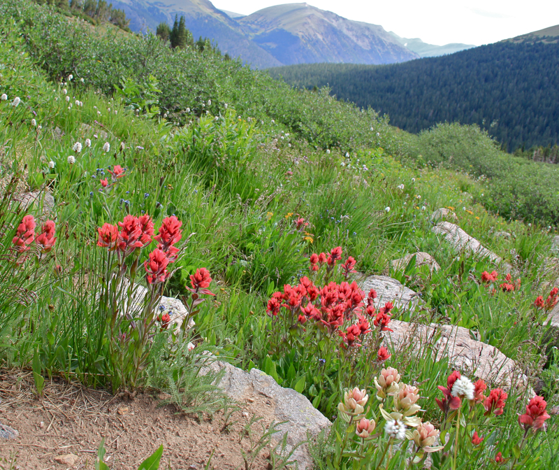
Near treeline the route gets very pretty with dwarf Sub-alpine Fir, Blue Spruce, and even Lodgepole Pine. Large swaths of wildflowers exist in every open space. At times the trail wanders through large stands of encroaching Willows. Be careful here. Large rocks loom that may send you pitching head over heels into the shrubbery.

Originally, we thought the lake was straight ahead at the back of the bowl. It is actually several shelves up and to the left.
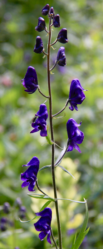
Wildflowers were still blooming, even in mid August.
The approach to the alpine bowl is deceiving. The lake appears to loom directly ahead when in fact it is located up a series of shelves to the left. As such, last half mile is a long series of switchbacks and false summits. Once on the proper shelf, it is still a short walk to the lake itself.

Heading up the last shelf
Arriving at the lake
There are plenty of dry places to lounge around the lake but few rocks, so early in the season the area may be a soggy experience. Directly ahead is the Continental Divide. Decatur Mountain is a craggy bump on the ridge to the left. While you can't see it, the Argentine Pass Trail is just below the ridge on the other side. From there you can climb Argentine Peak, which is the next peak along the ridge to the right. Finally, Square Top Mountain looms large to the east.

This Mountain Goat family (see the kid following the lead parent), were just white moving dots with the naked eye, but can be seen with a cropped photo taken with a telephoto lens.
Square Top Mountain
While lounging at the lake, we saw a family of Mountain Goats traverse the ridge from left to right. Others have reported similar sightings. Finally, be aware that this area is a thunderstorm magnet. They can be seen building from as far away as Silverthorne when other areas along the Divide are clear.

Wednesday, August 27, 2014

Arctic Gentian


Arctic gentians (Gentianodes algida) is a tundra flower that blooms in late summer. To some it heralds the coming of winter. Since it was first identified in Siberia, perhaps that is true! We saw these flowers all over the tundra in 2014. They were particularly abundant on the Arapaho Pass and Lake Dorothy Trails.

Wednesday, July 3, 2013

Angler Mountain Trail

Distance: 4.4 miles round trip to Ptarmigan Trail, 5.4 miles round trip to Bench
Elevation: 8,542ft -10,112ft
Elevation Gain: 1,571 ft (cumulative)
Date Hiked: 29 June 2013
Bathroom at Trailhead: No
Dogs: Off leash

View of the Tenmile Range in Silverthorne Colorado.  Viewed from the Angler Mountain Trail.
The Tenmile Range and open verdant meadows are only some of the attractions on the Angler Mountain Trail
In summer, the Angler Mountain Trail in Silverthorne, CO will make your eyes pop with the number and variety of wildflowers that dot the route. In the more forested sections Colorado Columbine fill every nook and cranny while on the more open Sagebrush hillsides Lupine, Scarlet Gilia, Blue Flax, Pontentilla, Cushion Buckwheat and many more ebb and flow with each undulation of the terrain. What is also amazingly fun, is the first mile of the hike contains placards identifying these flowers as well as the local trees and shrubs.

The Trailhead
The initial steep hillside.  Elevation gain is a consistent 500ft/mile.
The overall route is on the east side of Highway 9 and takes the hiker up and down verdant hills while slowly gaining altitude. The trail ends with its intersection with the Ptarmigan Trail and from this intersection it is only 0.5 miles to the Ptarmigan Bench, a series of logs in an open clearing with stunning view of the Gore Range.

Heading into an Aspen Grove
Wildflowers line the trail
Angler Mountain is relatively new trail and therefore not any of the maps you are used to looking at. The trailhead is located within the Angler Mountain Townhomes off Bald Eagle Drive in north Silverthorne. Take Bald Eagle Drive at The Ponds, cross the Blue River, and continue around the townhomes to the south and the prominent trailhead. The route starts sharply up a dry Sagebrush hillside and then proceeds to go up and down similar hills, some dry, some covered in young Aspen trees, and some shaded by Lodgepole pines.

Another open Aspen Grove
Approaching the new road at 0.7 miles
The early part of the trail winds through homes being built in the area and crosses a new road at 0.7 miles before gradually tapering off into more pristine areas.  At 1.8 miles the route reached the top of another hill and looking down the other side, the trail seemed to end abruptly at the bottom. I stood there staring for a while because I knew the trail continued having seen its apex on the Ptarmigan Trail but I did not want to descend only to find I had taken some wrong turn somewhere and was on the wrong trail. Finally, I descended the hill to find the trail continued but was totally hidden by the shrubs.

This pleasant Aspen tunnel was the gateway to the  wilder  meadows in the upper reaches of the route. 
Views of the Gore Range abound
After winding 2.2 miles and 1,216 ft up to the Ptarmigan Trail, I decided to head to the Bench, which I thought was only a hundred yards or so further on. It was in fact 0.5 miles.

Heading off into the more open expanses
Lupine line the trail
Despite the few forested sections of the trail, there is very little shade on this route, which made for a hot, dry climb. If you can, start earlier in the day to avoid the heat and the afternoon thunderstorms which build behind the Gore Range and come rumbling eastward as the day progresses.

A sharp switchback heading up another hill with more views of the Gore Range
One of the final pitches to the Ptarmigan Trail

Saturday, August 4, 2012

Butler Gulch

Distance: 6 miles round trip
Elevation: 10, 546 ft - 11,963 ft (at the Jean Mine)
Elevation Gain: 1,238 ft
Date Hiked: 14 July 2012
Dogs: Off leash, National Forest
Bathroom at Trailhead: No

Mountain Views on the Butler Gulch Trail
Butler Gulch,  near the large switchback on the way to Berthoud Pass, is a close-to-Denver alpine journey filled with wildflowers, waterfalls, historic mining ruins, and make-me-move-here scenic views. This trail is fantastic!

The parking area is just the road by a gate
While most of the route follows an old road, it  occasionally gets soggy
Columbine near the trail
Another stream crossing
You get to Butler Gulch by first turning off of Highway 40 at County Road 202 and then heading due west towards the Henderson Mine. Just before the mine, a dirt frontage road splits off and parallels the paved road.  Continue on this dirt road until the parking area right at the junction with the Jones Pass Road.  Park along the side of the road by a large gate.

Monkshead along the trail
The waterfall at 1.5 miles
Indian Paintbrush along the trail
Mosses extend like beach sand from the "forest" of this riparian ecosystem
The lower sections of Butler Gulch are soggy and tree shrouded with several stream crossings and numerous stands of wildflowers. As the trail rises, it comes to a long cascading waterfall at 1.5 miles and finally breaks out of treeline at 1.8 miles. From this point on, the trail travels westward across a wide alpine shelf and finally reaches the remains of the Jean Mine at 2.7 miles.

View to the west as the trail breaks out of the trees
Heading across the shelf to the mine
The Continental Divide to the north
More flowers because I could not resist
Wildflowers dot as well as carpet this high altitude play land and I found myself irresistibly drawn to them as our group continued on their way. I would scurry to catch up only to be distracted by the latest colorful bauble.

From the western end of the shelf looking back at the Continental Divide
Getting closer to the mine
The mine tailing come into view
The ruins of the Jean Mine are interesting as well.  Purists may be offended by the piles of metal, old cars, and defunct machinery that covers the area, but this is our Colorado history and it has been part of the landscape for good or evil for the last 100 years.

Playing with an old car
More ruins
Behind the mine and wrapping around the entire area is the Continental Divide.  There is also a small spur trail leading to a shelf that formally contained a small glacial tarn.

Near the mining ruins was a whole field of Indian Paintbrush
When you see clouds like this above treeline, you should run away!  
If you are from the Denver area and are trying to decide whether to petal peep at Diamond Lake in the Indian Peaks Wilderness or on Butler Gulch, choose the latter.  It will be significantly less crowed and may actually have more wildflowers.


North Rock Creek Snowshoe

Distance: 4 miles round trip Elevation: 9,180 ft to 9,780 ft Elevation Gain: 600 ft Dogs: Off leash until the wilderness boundary North...