Distance: 4 miles round trip
Elevation: 12,006 ft - 14,156 ft
Elevation Gain: 2,150 ft
Date Hiked: 1 September 2011
Dogs: Off leash
Bathroom at Trailhead: Yes
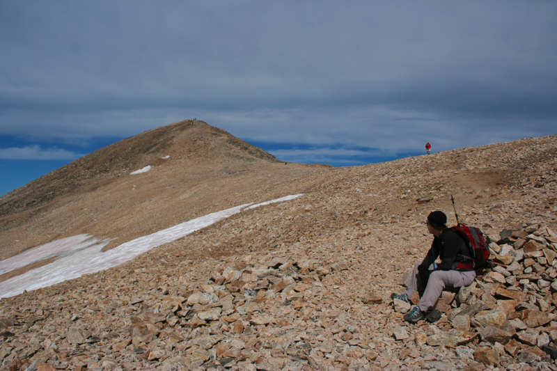
 |
| View (looking north) from the summit of Mt. Democrat |
Mt. Democrat is an easy 14er within striking range of the Denver Metro Area and is therefore rather popular. I have long ago given up climbing 14ers on the weekends for this reason. Even during the week, one is hardly alone.
 |
| The parking area. The saddle and face are directly ahead. |
 |
| Starting out, the lake is just ahead |
 |
| The easiest part of the route is across the valley on a relatively soft trail. |
 |
| The route gets rockier as you start to head up. |
 |
| Looking back down on the lake |
The trailhead to Mt. Democrat begins south of the Breckenridge Ski Resort in the town of Alma. In the middle of the town, look for the road and small brown sign pointing towards Kite Lake. It is 6 miles up a dirt road that is usually passable by a passenger car to the lake. The forest service runs the campground, bathrooms, and parking lot. There is a $3 fee to park there. If such conveniences are above you, park down the road a bit where it is free.
 |
| Now we are really into the rocks. |
 |
| Heading towards the saddle |
|
|
 |
| Looking back down the valley |
 |
| Looking up at the dots on the saddle |
 |
| Democrat, Lincoln, and Bross have been are still are heavily mined. That is one reason that Bross is still closed. A mine shaft and sign occupy the saddle. |
Democrat can be hiked by itself or part of the triad of Democrat,
Lincoln, and Bross. At the time I did the hike, Bross was still closed
to the public, although that did not stop many. Doing all three in one
day is certainly doable, legal issues aside, and is primarily weather
and time dependent. In my case, my two hiking companions came up from
Denver and got stuck in traffic caused by an overturned semi-truck. We
got too late a start to do more than Democrat.
 |
| There is a small "bump" before you start really ascending the face. You can see the hordes going up and coming down. |
 |
Depending upon how you scramble over the "bump", you can look straight down into the opposite valley. That is actually Wheeler Lake in the distance. There are some great views of Mt. Democrat from that trail.
|
 |
The "bump"
Looking across to the route up Mt. Lincoln (14,286 ft). That is actually Mt. Cameron (14, 238 ft) , a 14er that does not count. Mt. Lincoln is out of view. |
|
|
|
|
|
|
|
The face you see as you start to climb is not the face of Democrat. The actual summit is a small hump further up the ridge to the west. This becomes readily apparent when you reach the top of the face only to see folks heading off into the distance.
 |
| Heading up the face |
 |
| Reach the top of the face, the summit is in the distance |
Getting to the saddle between Lincoln and Democrat is the hardest part
of the hike. That is why it is such a bummer NOT to do both in one day.
 |
| It is an easy walk to the summit from this point. |
 |
| The summit |
 |
| The summit view looking down the north valley |
 |
| Looking down on the Climax Mine from the summit. I have driven that highway many times and never knew I was looking up at Mt. Democrat. |
Many of the folks that do Democrat, Lincoln, and Bross do so as a loop and come down Bross to Kite Lake. Every report I have read about this indicates that sliding down Bross is not an experience most people care to repeat.


3 comments:
Thanks for the post! It came into my email just as I am searching for hikes. Manitou Springs area tomorrow, but I added your blog to my list of great sites to check for hike suggestions. Keep the great photo journal going!
Happy hiking!
Love all the pictures. I had a chance to do this hike (as well as Cameron, Lincoln, and Bross) over the summer. My first 14ers. So many people though!
Thanks Scott. Ya, 14ers are a crowded mess. I have yet to do Bross. It is technically "closed". I would like to try it from the east side at some point.
Post a Comment