Distance: 6 miles round trip
Elevation: 12,000 ft - 14,286 ft
Elevation Gain: 2,286 ft (net) 2,547 ft (cum)
Bathroom at Trailhead: Yes
Fees: $3 to park near bathroom, you can park down the road if you prefer
Dogs: Off leash
Date Hiked: 1 Aug 2013
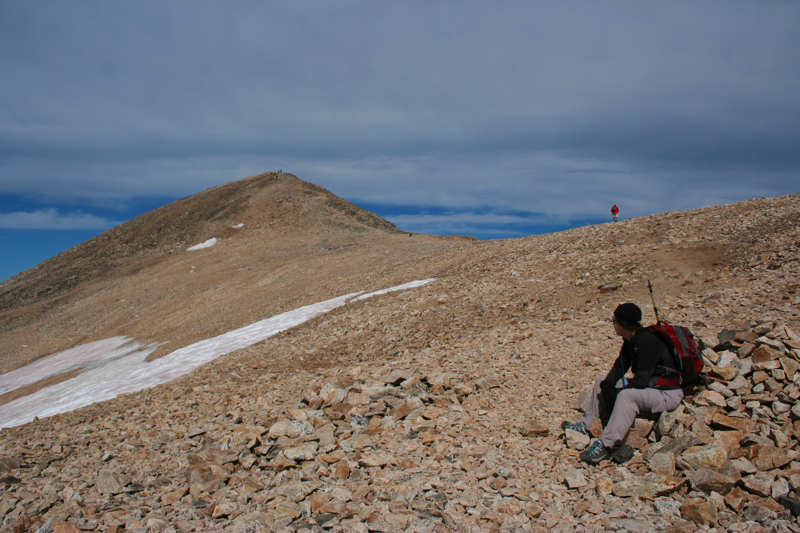
 |
| Looking back towards Mt. Cameron from the summit of Mt. Lincoln |
Mt. Lincoln near Alma CO is one of the 54 14,000 ft peaks in the state. Climbing these mountains is huge past time in Colorado and you see every type of person along the way. There are tourists that come here every year just to climb a few and locals who want to bag them all - tattooing the number 54 on their foreheads as a badge of honor everyone will recognize.
 |
| The trailhead at 7am on a Thursday |
 |
| The flat, cushy start of the route. Our destination is beyond the ridge in the distance. |
I like climbing 14ers because the physical challenge keeps me in shape all winter. I confess the discrete list allows anal people like myself to start cataloging ascents, reviewing them periodically like stamps in a passport. They are tickets to some of the wildest places on earth, and each one is a milestone to be proud of. There are of course true mountaineers out there that scale the grand peaks of the Himalayas or in Patagonia. I like just being able to wake up one morning and stand on the summit of a mountain without having to trek to the end of the world to do it. This is back yard play for those of us who live here.
 |
| And the slog begins |
 |
| Tallus and skree will be our companions from now on. |
The trail to Mt. Lincoln starts at Kite Lake near Alma Colorado.
Mt. Democrat, Mt. Lincoln, and Mt. Bross are three 14ers so close together that many try to do them all in one day. You need good weather to do this and a tendency towards juvenile delinquency since the summit of Mt. Bross is still officially closed as of the date of this post. All of these mountains are riddled with mining tunnels, some only inches from the surface. It has taken a long time and lots of legal wrangling to open them up to public use. The city of Alma actually kicked in liability insurance.
 |
| You can see how Kite Lake got its name |
 |
| Continuing upwards but don't be fooled, the saddle is still far away. |
I climbed
Mt. Democrat two years ago but did not have decent enough weather to continue and ran into the same problem this time. It seems like the perennial "get an early start" is not a sufficient safety margin anymore. Our once predictable monsoon period has evolved into an erratic you-never-know kind of world where storms can pop up on days foretasted to be half-way dry. It seems like nowadays you either just have to hope you haven't pissed of the gods lately or wait until September when things really dry out. I climbed
Square Top Mountain last September and could have stayed on the peak for days.
 |
| The saddle comes into view. There are many hikers in the distance. They are dots compared to the scale of the slopes of Mt. Democrat to the left. |
 |
| On the saddle looking up at the ridge that begins the route to Mt. Lincoln |
The initial part of the route to the summit is a 1.5 mile slog up to the saddle between
Mt. Democrat and Mt. Lincoln. It is really an unpleasant segment that I have done twice now. The deceiving thing about Mt. Lincoln is that the peak you see from the saddle or from the summit of
Mt. Democrat is not even close to the summit, it is just the beginning of the long ridge you have to traverse before you even get to Mt. Cameron, an uncountable 14er.
 |
| Finally we start for Lincoln. This half of the route is much more interesting. |
 |
| You could not blink without seeing a Pika. They were all over, chirping, feeding and scurrying between the rocks. This one would fit into the palm of my hand. |
For those of you who are unfamiliar with Colorado's 14ers, there is a nifty rule, probably established by a group of bored bureaucrats, that says no peak can be an "officially" ranked unless it stands alone. It must be 300 feet above the saddle to any other peak and poor Mt. Cameron just doesn't rate. It is only hundred feet or so between Mt. Cameron and the saddle below. While I totally get this rule, they should not have named the peak because everyone is woefully confused by the whole thing. There are plenty of unnamed 13ers out there, they could have just left the bump that is Mt. Cameron alone.
 |
| Looking back on the route. That is the trail up Mt. Democrat in the distance. You can see tiny ants gathered on the summit to the right. |
 |
| This Marmot was guarding the upper reaches of Mt. Lincoln. |
The surprising length of the ridge to Mt. Cameron is one long, continuous, "don't stumble" view of
Wheeler Lake to the north with one 30 yard ridge walk with drop offs on either side. While exposed, this is not
Devil's Causeway scary because the ridge is wide enough. I did find my vision going in and out of focus, however, as it shifted from the rocks below to the yawning abyss on either side.
 |
| We finally crested the ridge that you can see from the saddle only to see this long ridge walk ahead. |
 |
| Add the ridge still goes on. We thought perhaps it was Mt. Cameron above us, but no. |
Don't assume that any of the broad bumps you pass along the way are Mt. Cameron. We kept assuming we had passed it and were on our way to Mt. Lincoln. The summit of Mt. Cameron is broad and flat and you can see the nipple-shaped false summit near Mt. Lincoln clearly in the distance.
 |
| The exposure eases but the route continues. That is Mt. Cameron, far in the distance. |
 |
| Finally on the summit of Mt. Cameron. The broad summit and small, collapsed cairn is your clue. The summit of Mt. Lincoln is in the distance. |
It was on the broad, exposed summit of Mt. Cameron that our hike became an adventure. It was 10am and we had been hiking for several hours when behind us we heard a huge clap of thunder. The multitudes started spinning in circles, acting like a bunch of disturbed fire ants. The reality was at this point we were all totally screwed. Many chose to head back to the trailhead but that was a several hour journey on an exposed ridge walking into the storm. We chose to descend to the other side of Mt. Cameron and hunkered down in a small depression at its base. While the storm blew over us, we watched some hardier folks continue on to the summit and stand there amidst the swirling black clouds. To each their own. Fortunately for us, the storm moved on and we were able to complete the route.
 |
| My favorite part of the route, the broad plateau between Mt. Cameron and Mt. Lincoln. What planet are we on? |
 |
| Standing at the base of the plateau, looking up at the nipple that exists between Mt. Cameron and Mt. Lincoln. |
The saddle between Mt. Cameron and nipple on the way to Mt. Lincoln seemed like something out of a Sci Fi movie. Desolate and otherworldly, I could have been visiting Planet X, my space ship behind in the distance. The temperature had dropped quite a bit and all the hikers could have been spacemen, bundled up in all their gear. These reflections made me realize that the tops of Colorado's mountains are really worlds apart. Despite the hordes, they are not meant for human visitation.
 |
| Crossing the nipple, the summit is in view |
 |
| The final approach to the summit |
Our journey down took longer than expected. Some people can fly down skree in one continuous controlled fall. I am far too Ma Ma for that and take my time, which gets ponderous after a while. Still, the views coming down are very cool and you will want to stop and admire your physical prowess as you see how steep the ascent really was.
 |
| The Class II scramble to the summit is not difficult at all and takes seconds to complete. |
 |
| Wheeler Lake to the northwest viewed from the summit. |
So since the weather prevented us from getting anyway near Mt Bross, I will someday have to get back up there. There were plenty of people who made the trek despite the weather and the rules. I sort of envy them. If I do go, however, I will take a different route just for varieties sake.
 |
| Obligatory summit shot with my friend Lynn...go girls!! |
If you have to choose between
Mt. Democrat and Mt. Lincoln, particularly
on a day when the weather is threatening, go for
Mt. Democrat. You'll
be able to descend much faster if you need to. If you are physically up to it, and the Force is with you, do all three
in one day. You'll only have to climb to the saddle once.