Distance: 5 miles round trip
Elevation: 5,120ft - 6,250ft
Elevation Gain: 1,237 ft (cumulative)
Dogs: Off leash in designated area with Boulder green tag
Bathroom at trailhead: Inside NCAR
Tags: #OSMP, #boulder, #hiking, #coloradooutdoors
 |
| A hike from NCAR to the Mesa Trail and beyond takes you along the scenic Flatirons. |
Nestled next to the Flatirons in Boulder, CO is warren of trails that can be combined in all sort of ways. This post describes a out and back that starts at NCAR, the big pink castle on the hill, and travels the Mesa Trail south down to Kohler Mesa. Most of the trails along this route are owned by Boulder but part of them belong NOAA. For those who want to bring their dogs, leash restrictions vary and you'll be putting your dog on and off leash.
 |
| Map of the route. The red circle is the water tank. The red square is the picnic table at the end of the route. |
 |
| The first 0.2 miles of trail is an interpretive trail behind NCAR. |
 |
| The towering 3rd Flatiron from the trail behind NCAR. |
Any outing in Boulder that starts from NCAR has one major advantage. You'll never run out of parking! As Boulder continues to grow, parking at various trailheads continues to be a problem. Most fill up by 8am and have a parking fee for non-residents to boot! NCAR has hundreds of parking spots, and while the ones closest to the trailhead will be full, you can always find a spot.
 |
| Heading down the south side of the mesa NCAR sits on |
 |
| Turn right at this junction and it will connect to the Mesa Trail going north |
The route begins on the north side of NCAR and follows an interpretive trail for 0.2 miles before heading down the south side of the hill. The trail then travels down and around and then up the steep slope of a hogback to a large green water tank. The Mesa Trail is located on the backside of the hogback, down another series of trails with million dollar views of the Flatirons.
 |
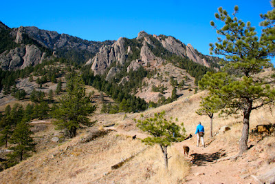
| On the Mesa Trail heading south |
 |
| Snow and Ice can collect in this gully in winter |
On the west side of NCAR, the Mesa Trail weaves up and down to the junction of the Kohler Mesa Trail at 1.4 miles. It is a short 1 mile across Kohler Mesa to the NOAA trailers and a picnic table on the right. From this vantage you are gazing across the plains. The NOAA complex is just below with the University of Colorado nearby.
 |
| Heading up the north side of the gully |
 |
| Further along the Mesa Trail |
For the return, you can retrace your sets or descend off of Kohler Mesa to the Skunk Canyon Trail (see map), which parallels Kohler Mesa at the bottom of Skunk Canyon. Head west on this trail and it will eventually climb back up to the Mesa Trail.
 |
| Ponderosa Country |
 |
| On the eastern end of Kohler Mesa. The gate ahead marks the boundary with NOAA property. |
 |
| Trailers on NOAA's property |


3 comments:
Seems like a competitive business, if car parks are full by 8am!
Great hike. We went today (05/2015) and the first portion was swamped with tourists, but otherwise it was serene. We added to the loop with the Wood Quarry trail about 1/2 way through and it was a nice addition of some elevation and distance.
Hi Dorian, Try going up via the new skunk canyon trail. There will be less people. http://colorado-lifestyle.blogspot.com/2014/05/skunk-canyonkohler-mesa-loop.html
Post a Comment