Distance: 6.4 miles round trip
Elevation: 11,307ft - 13,132 ft
Elevation Gain: 1,832 ft
Dogs: Off leash
Bathroom at trailhead: Yes, but TP can be limited
 My friend Barbara next to the summit cairn
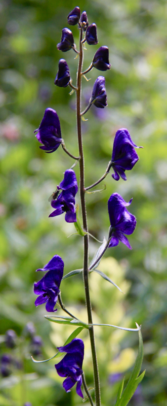
Hiking Mt. Flora is like a free trip to a Swiss Disneyland with E-ticket views. Listen closely and you may just hear a distant Swiss Horn or some blissed out hiker belting out show tunes from the Sound of Music. Hike this trail at the height of the tundra flower season and you'll know why they named it Mt. Flora. I kept alternating between shoving my nose in the turf and jumping up to admire the vistas. Whiplash is an unexpected hazard on this trail!
 Sign at the trail head
 The first part of the trail is on a dirt road surround by Spruce and Pine.
The trail itself was mostly packed dirt and the one small rock pile on the route has had steps placed through it. After trudging up
Mt. Audubon the day before, I felt like I was levitating up Mt. Flora. I certainly did not need my heavy boots. As mountains go, Mt. Flora is very accessible.
 Sign at the beginning of the single track trail
 Heading off on the single track trail
The trail up Mt. Flora begins at Berthoud Pass. There is a restroom at the pass, but bring your own supplies. Tourists from far and wide stop here on the way to Winter Park and Steamboat Springs.
 Taking a break on the open tundra. The road in the distance is highway 40.
 James Peak and the open tundra views
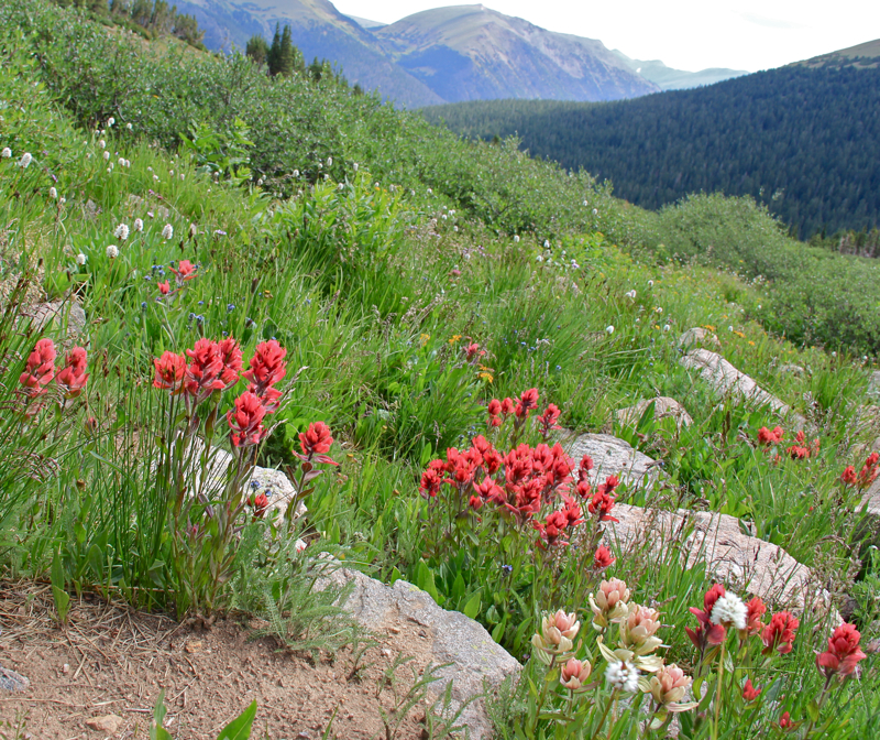
The route begins up a wide dirt road that heads up to the top of Colorado Mines Peak, another 13er, covered in industrial looking buildings. At 0.89 miles (11,700 ft), a small sign appears directing the hiker off the road and onto a single track trail that skirts the peak. This is where the fun really starts. In the distance, looms Long's Peak and the Mummy Range, while all around is the verdant grasses of a nearly empty slope. This is where I started to channel my inner Julie Andrews. What is it about a green field dotted with flowers that makes us all want to start racing across it. I get jealous of the dogs who have the sure footedness to do so without breaking their necks. My middle-aged body would not fare so well.
 View from the saddle with Colorado Mines Peak
 Looking up to the left from the saddle. This section is steeper than it appears.
After skirting the side of the Colorado Mines Peak, we reached a saddle (1.64 miles, 12,138 ft) with a grab-your-chest-and-gasp view of a hidden lake and valley. While I know that I-70 is just beyond the entrance to this valley and that the area is not wilderness, it still had that feel of discovering something totally new. Flowing green tundra grasses filled the slopes and the small tarn was surrounded by bucolic willows. Leading up the valley was a rivulet of coniferous trees. This spot is a worthy destination in and of itself for those who don't want to climb all the way to the summit.
 Looking back on Colorado Mines Peak
 Flowers are abundant on Mt. Flora in late July.
To the left of this view is the other side of the saddle. Climbing up this wrinkle in the earth was the most strenuous part of the trip. It was both steep and somewhat slippery with loose dirt, but oh the views. The higher we climbed the more expansive the mountains around us became. Colorado Mines Peak becomes a bump and the Gore Range blends with the Ten Mile Range to form a continuous row of snow dotted mountains from north to south. Additionally, the larger peaks of the Continental Divide (
Grays Peak,
Torreys Peak,
Square Top Mountain, Grizzly Peak, etc) are clearly visible. I am lucky I did not fall off the hillside with all my twisting around to take it all in. At 2.31 miles (12,730 ft) you can finally see the summit.
 Higher up the steep section, looking back on Colorado Mines Peak
 Views of the Gore Range and the Ten Mile Range kept me turning around.
Don't let this steep section fool you, there is still some distance to travel. A short ridge walk ends at a small pile of boulders and talus. The folks at this mountain Disneyland have made this obstacle trivial by placing convenient flat rocks in the form of steps all through it. Within seconds, we reached the top (2.7 miles, 12,858 ft) for another surprising view down to a valley and its tarn. The whole back side of this area is gorgeous.
 Ginger, the wonder dog, takes a VERY RARE break from her continuous and joyful running. Is she as enamored of the flowers as I was or is it Pika droppings that have her smiling?
 The rest of the crew catches up. In the far distance is Grays and Torreys, two Front Range 14ers.
From the rock pile, it is only a short 0.5 miles to the summit, which is very obvious. There was a stream of folks coming off the top, but these were the only people we saw, and by the time we settled in with our 360 degree view and our peanut butter sandwiches, we had the place to ourselves.
 After the steep section, the summit comes into view (far right bump).
 The rock pile
Now in addition to the views already mentioned, one can clearly see Mt. Evans and
Mt. Bierstadt to the southeast and James Peak a stones throw away to the north. Looking down the precipitous drop off is tiny Ethel Lake. The summit is wide and broad. We had to wander around a bit to focus on the views in different directions. More tundra plants were growing amongst the rocks and the weather was sublime. Our group must have hung out for over an hour marveling at the world laid out before us. Colorado really is grand.
 The surprising view from atop the rock pile
 On the summit and looking southwest
If you can't tell by my many superlatives, I really liked Mt. Flora. It is easy and therefore accessible to the average hiker, the views are some of the best I have yet to see in Colorado, and we had the place to ourselves. My witnessing to this wonderful location may spoil it in the future, but I do feel that everyone who lives here should enjoy Mt. Flora at least once. It will fill your soul with gratitude for the wonders of our State and the natural beauty we get to have for free.
 A broader view of the seemingly continuous waves of peaks
 Alpine Avens (Acomastylis rossii turbinata) on the summit. This flower grows only in the tundra and can be seen from mid-June to early August.
Disneyland comparisons aside, I would be remiss if I did not remind you that Mt. Flora is a mountain above 13,000 ft, which means all the usual precautions apply. Watch the weather, carry water and layers, slap on plenty of sunscreen, and be emotionally prepared for gale force winds.
 Moss Champion (Silene acaulis subacaulescens) seems to be the most predominate flower on Mt. Flora. Moss Champion grows only in the tundra and can be seen from late-June to early August. It grows like a carpet in the nooks and crannies of rocks.
 Looking down on Ethel Lake
I would suggest looking to climb Mt. Flora in the last two weeks of July. By mid-August many of the flowers are gone. The tundra still has an appeal in the late summer to early fall, but to really commune with everything Mt. Flora can be save it for a mid-summer reaffirmation of life, color, and open sky and don't forget to bring your lederhosen
 Heading down
 A final goodbye to the flowers of Mt. Flora. This whole hillside was filled with Alpine Avens.