Showing posts with label mining history. Show all posts

Saturday, October 6, 2012

Bachelor Loop Scenic Drive

The Bachelor Loop near Creede Colorado is a 17-mile scenic drive through mining ruins and forested plateaus.  The most interesting part of the loop is at the north end of Creede and is filled with mining ruins clinging precipitously to the hillside.  Other than some great views of the Rio Grande Valley as you descend on the downward side there is not much happening in between.  The ruins are neat however but if you don't want to do the entire drive,  you could turn around after the steep drive up past them.

Commadore Mine on the Bachelor Loop near Creede Colorado is just one of the many scenic ruins in the area.
Commodore Mine
Trestle used to take ore cars out of the mine
Creede was established in the late 1800s because of the Amethyst Vein (running along West Willow Creek canyon), a 4-10 ft wide vein of silver ore that occasionally reached 100 feet in width. As with all such places in Colorado, such riches resulted in mines, towns, tent cities, and colorful characters such as the card shark Poker Alice and Calamity Jane.

Amethyst Mine
These ruins of the Last Chance Mine look like they could fall down the hillside at any time.
Lots of cars were stopped here at this open meadow, which is all that remains of Bachelor City
The Commodore mine doesn't look like might now, but it has 5 different levels spread out over 200 underground miles. Located at the southernmost extent of the Amethyst Vein, it was in production from 1891 all the way to 1976!

Looking east down into the Rio Grand Valley, with Creed far below 
Looking southwest 
Further down now.  Creed is more visible. 

Saturday, August 4, 2012

Butler Gulch

Distance: 6 miles round trip
Elevation: 10, 546 ft - 11,963 ft (at the Jean Mine)
Elevation Gain: 1,238 ft
Date Hiked: 14 July 2012
Dogs: Off leash, National Forest
Bathroom at Trailhead: No

Mountain Views on the Butler Gulch Trail
Butler Gulch,  near the large switchback on the way to Berthoud Pass, is a close-to-Denver alpine journey filled with wildflowers, waterfalls, historic mining ruins, and make-me-move-here scenic views. This trail is fantastic!

The parking area is just the road by a gate
While most of the route follows an old road, it  occasionally gets soggy
Columbine near the trail
Another stream crossing
You get to Butler Gulch by first turning off of Highway 40 at County Road 202 and then heading due west towards the Henderson Mine. Just before the mine, a dirt frontage road splits off and parallels the paved road.  Continue on this dirt road until the parking area right at the junction with the Jones Pass Road.  Park along the side of the road by a large gate.

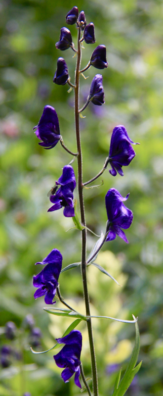
Monkshead along the trail
The waterfall at 1.5 miles
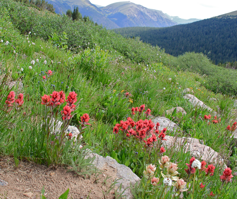
Indian Paintbrush along the trail
Mosses extend like beach sand from the "forest" of this riparian ecosystem
The lower sections of Butler Gulch are soggy and tree shrouded with several stream crossings and numerous stands of wildflowers. As the trail rises, it comes to a long cascading waterfall at 1.5 miles and finally breaks out of treeline at 1.8 miles. From this point on, the trail travels westward across a wide alpine shelf and finally reaches the remains of the Jean Mine at 2.7 miles.

View to the west as the trail breaks out of the trees
Heading across the shelf to the mine
The Continental Divide to the north
More flowers because I could not resist
Wildflowers dot as well as carpet this high altitude play land and I found myself irresistibly drawn to them as our group continued on their way. I would scurry to catch up only to be distracted by the latest colorful bauble.

From the western end of the shelf looking back at the Continental Divide
Getting closer to the mine
The mine tailing come into view
The ruins of the Jean Mine are interesting as well.  Purists may be offended by the piles of metal, old cars, and defunct machinery that covers the area, but this is our Colorado history and it has been part of the landscape for good or evil for the last 100 years.

Playing with an old car
More ruins
Behind the mine and wrapping around the entire area is the Continental Divide.  There is also a small spur trail leading to a shelf that formally contained a small glacial tarn.

Near the mining ruins was a whole field of Indian Paintbrush
When you see clouds like this above treeline, you should run away!  
If you are from the Denver area and are trying to decide whether to petal peep at Diamond Lake in the Indian Peaks Wilderness or on Butler Gulch, choose the latter.  It will be significantly less crowed and may actually have more wildflowers.


Thursday, July 26, 2012

Lomax Mine

The entrance to the Lomax Mine historical area near Breckenridge
The Lomax Mine is a series of historic buildings near Breckenridge from a Gold placer hydraulic mine circa 1860.  Gold being a heavy metal tends to sink in water, so a placer mine ran water over gold bearing rocks and the gold would sink to the bottom of long sluices. A hydraulic mine is one that used large water canons to blast away the surrounding hillsides and run it through the sluices.

You can wander around the buildings or pay $10 for a tour that includes a history lesson. Iowa Hill south of town has a more extensive exhibit of this type of mining but also involves a hike. This exhibit is suitable for aged parents or small children.  

Old mining building
Plow
Indian Paintbrush near picnic tables at the back of the property
Looking back at the parking area 
Sluice Box
Hydraulic Cannon 
Close-up of the log construction
Broader view of the area
The Lomax Mine is located at 301 Ski Hill Road on the way to the Peak 9 ski lift area. From the Blue River Plaza in the center of Breckenridge, proceed north (toward Frisco) on Main Street one block to the stop light at Ski Hill Road/Lincoln Ave. Turn west (toward the mountains) onto Ski Hill Road. Proceed past the stoplight at Park Ave. and drive about 1/4 mile uphill to a Lomax Mine sign on the left and a driveway into the mine parking lot. Turn left into the parking lot.

Saturday, April 9, 2011

Battle Mountain Trail

Distance: 1 mile round trip
Elevation: 9,800 ft - 10,000 ft
Elevation Gain: 200 ft
Dogs: Off Leash

Looking up at the Independence Mine headframe from the parking lot

The area around Cripple Creek and Victor Colorado is filled with mining history and short trails you can take the family on. I road tripped to this area a few weeks ago as a way to get out without having to hike very far. I am recovering from an injury or at least trying to. We did the Vindicator Valley Loop, which is a mecca for history buffs, as well as Battle Mountain.

The rock sorter under the canopy

Heading west on the well manicure rail bed

Battle Mountain is a short trail up to a skyscraper-like headframe of the Independence Gold Mine. Under a canopy is a rusted pipe filled with holes of many sizes. This remnant was part of a system that sorted rocks into various bins for crushing and gold extraction. A small informative display explains the process.

Looking back on the headframe

Just beyond the canopy there is a metal bridge over a mine shaft that seems to disappear into the very center of the Earth. Even though it is covered in a metal mesh to protect the tourists, the shaft has an ominous feel. Its looming darkness and jagged edges is surely the denizen of some primeval monster, a destroyer of worlds. Perhaps it was just the wind moaning in the headframe but the shattered mania of gold fever still echoed from the deep, a destroyer indeed.

The town of Victor. You can just see the Sangre de Cristo Mountains in the distance.

Beyond the bridge a well manicured path follows an old railroad grade to a view of the Portland and Cresson Mines amidst a pile of yellow debris. From this point there is a nice view of Victor itself and the Sangre de Cristo Mountains beyond.

Looking up at the Portland Mine. This viewpoint is pretty much the end of the trail.

I would not drive all the way from Denver to Victor for this trail, but combined with other trails or adventures in the area, it is a worthwhile destination.

From the parking lot you can see Pikes Peak and the main ruin at the start of the Vindicator Valley Loop

North Rock Creek Snowshoe

Distance: 4 miles round trip Elevation: 9,180 ft to 9,780 ft Elevation Gain: 600 ft Dogs: Off leash until the wilderness boundary North...