Monday, March 23, 2009

Sedona: Overview

Cathedral Rock seen from Upper Red Rock Crossing Rd.

Sedona is a touristy and quirky little town situated in an oasis of geologic wonders. Surrounding the town are monumental spires of spectacular red rocks. The bright orange-red rocks are more than 250 million years old. You have to have been employed since then to afford to live here, however. You can afford to visit, and should.

Whether it is panoramic views, serious gallery hopping, or new age vortex worshiping, Sedona has something for everyone. I will be here a week with my parents and who knows what we will end up doing. I shall try to blog it all. This post will become my index to which I will add links to all the posts. One advantage of traveling with my parents is that they walk slowly, so I can snap a 1,000 pictures without getting on anyone’s nerves.

Topographic image of the Colorado Plateau. The Mongollon Rim is the edge of this Plateau

Sedona is all about geology, so here is the “dirt” on what you will see if you visit.

The rocks of Sedona are primarily sedimentary, which means layered. It is sort of reminiscent of the soap scum in your bathtub if you don’t scrub it out sufficiently, it just keeps building up. About 320 million years ago, the area of Sedona lay under water in a sea, and the first layer of Sedona's rock formation came from the shells of sea creatures. The next layer arrived about 275 million years ago as sand that was eroded from ancient mountains was carried by ancient rivers and deposited in a delta. This continued for a really long period of time. Much of the colorful rocks in the area were formed this way. Their technical name is the Schnebly Hill Formation. Eventually, about 1900 feet of rock covered the entire Sedona area.

At the Bell Rock (out of the picture to the left) overlook on Highway 179

Several million years ago, the Colorado Plateau uplifted, which created numerous cracks in this broad area of sediment. Water flowed in, sediment flow out, and we are left with these wonderful formations. The formations survived the process because they are capped with a protective layer of white limestone.

This rock is red because of iron oxide. Iron oxide drains through the porous sandstone and coats the grains, giving it a rich red color. Outside of Sedona’s unique oasis the rest of this part of Arizona consists of bleak rolling hills covered in desert shrubs. It is no wonder that people are drawn here by the millions. Take note oh millions, there are only about 500 parking spots in town so most of you will be driving around looking an opening, creating quite a traffic snarl. At least there is a pretty view to keep you entertained while at it.

Looking west from Upper Red Rock Crossing Road. The two small spires in the middle of the picture are near the famous chapel.

To make matters worse, at least for us, is that the bright folks in Sedona have decided to expand the major road, highway 179 that runs through town. So for the moment there is a very unattractive and highly annoying cone zone impeding the entrances to all the galleries. In the end though it will be much improved.

Our first day consisted of some scenic drives to visit ancient Indian sites. That will be the subject of the next few posts.

Trip Index:

Wednesday, March 4, 2009

Hefferman Gulch Snowshoe

Distance: 3.5 miles round trip
Elevation: 9,452 ft to 10,550 ft
Elevation Gain: 1,098 ft

Left: Road sign on Hwy 103. Parking is just along the side of the highway itself.

Hefferman Gulch, off Hwy 103 going towards Mt. Evans, is a pleasant snowshoe that is close to Denver and yet devoid of people. I saw one couple about 0.5 miles from the trailhead on my way back and that was it. Unlike my recent trip to on a fire road off Guanella Pass, this trail was open and airy.

I confess that I stumbled across this snowshoe looking for another one, Idaho Springs Reservoir, which turned out to be about 1 mile further up Hwy 103. It was not until I got back to the car and consulted the guidebook that I realized the route I had taken was profiled. Most people travel up Hefferman Gulch Road to the South Chicago Creek trailhead. From there you can continue another 1.5 miles into the Mt. Evan’s Wilderness. I decided to stay on the road, however, until I lost the trail in the trees.

Distinctive rock formation to the right of the trail

Openness of the area

Hefferman Gulch is not pristine wilderness. The road is doted with cabins of all sizes and shapes. Just as I was returning to my car, an older couple was heading up with their snow cat and several coolers, magazines, and pooches. I am curious how much the real estate is in that area. Seemed like a nice place to own a cabin.

My pup Ginger heads up the right for at the first junction. You can just make out the "no outlet" sign in the trees to her left.

There are several easy milestones on this road. Within 0.4 miles there is a very large rock formation to the right of the road. This borders a large open meadow.

Typical cabin along the road

0.7 miles from the trailhead is a fork. There is a large sign pointing to the left that says “no outlet”. Stay to the right here.

The road past the South Chicago Creek Trailhead was more narrow and devoid of snow.

0.4 miles farther on is another fork. The left fork leads to the South Chicago Creek trailhead, while the right continues upwards. On this trip I stayed to the right. After this point, the road becomes narrower and heads up a tall ridge surrounded by Aspens.

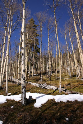
Apsens to the right of the trail. There is more moss than snow.

Around 0.5 miles beyond the South Chicago Creek trailhead, the road seemed to dead end in a small meadow. I could see what looked like a trail heading off to the right with a steep ascent. I followed this for short distance until I could no longer follow any trail. There were aspens everywhere and while it would have taken some effort to get lost, particularly with snowshoe tracks, I decided my fun meter was pegged, and I turned around. Later I studied a topo map of the region and saw that from the trailhead junction, the trail/road continues on quite a distance in a large sweeping arch to the north.

The open meadow that might make a more obvious turn around point.

Because of the conditions at the trailhead, I had left my snowshoes in the car and had headed up with just Yak Traks. That was a mistake. While the snow was packed down, it had been driven by a vehicle, so it was rutted, soft, and slippery. Snowshoes, while not technically necessary would have made the going easier.

I followed the trail until it led into these trees.

This snowshoe is not filled with spectacular views but it is open, filled with solitude, and accessible to dogs. Sometimes braving the I-70 traffic is just not feasible. When this is the case, consider Hefferman Gulch. This year the snow on the eastern side of the Divide has been sparse. In other years, it has been impassible. A good snow year would make this trip even more enjoyable.

A frozen Echo Lake

Echo Lake is 4 miles farther up Hwy 103. I drove up there to admire the view and to each my lunch. On a nice fall day, Echo Lake is a pleasant destination for a family picnic. There are tables, bathrooms, and an easy trail around the perimeter. For views farther up, check out my post on Mt. Evan’s Summit Lake.

Saturday, February 21, 2009

Old Monarch Pass Rd Snowshoe

Distance: 2.6 miles round trip to the pass
Elevation: 10,939 ft to 11,392 ft
Elevation Gain: 453 ft


The summit of Old Monarch Pass and the blowing snow.

In January of 2006, I took a road trip to Salida for Martin Luther King’s birthday. One day we hiked in the rocks to the west of Salida and the next day we did a short snowshoe up the Old Monarch Pass Road.

I decided to profile this very short trail because as you can see from the pictures, the conditions were less than perfect. Most of my trips, rejoice greatly, show relatively benign weather. In the mountains, however, you take what you can get. It was this trip that made me invest in a facemask and goggles. I have used them occasionally since then.

Beginning of the trail. You can see the sign in the picture above at the tip of the left most tree.

The trailhead is near Monarch Pass, which is the pass over the Continental Divide on Hwy 50 between Salida and Gunnison. It is 18.2 miles up Hwy 50 and is very near the Monarch Pass Ski Area. The current road takes a different route up and over the Continental Divide and this snowshoe follows the old road. There is a large pullout on the right and a sign.

Since it is an old roadbed, it is very gradual and suitable for the novice. Part of the route travels right next to a downhill run of the ski area. We ended up attracting attention with our dogs by a couple of dog loving skiers. It turned out later we were staying in the same hotel.

A little farther up the trail. For perspective compare the trees on the upper most knoll with their location in the previous picture.

After taking a couple of bends, the route goes around a sharp corner to the old pass. There is a sign proclaiming it that can be seen from the start of the trail. When we reached the pass, the wind was blowing snow into our face and eyes so that it was hard to see. The road does continue for another nine miles down the other side, which would make a nicer and longer journey, but on this day, without goggles, it was a no go.

Across the road from the sign. You can see that the road continues. Around this bend was a blizzard.

Salida made a great weekend getaway and if we go again, I would certainly considered checking out more trails in the Monarch area. If your time is short, this trail is very easy and very doable but a bit of a drive from Salida. The guidebook says that from the summit, there are stunning views of the entire breadth of the Rockies from Pikes southward. On this trip all we saw was snow. Please check it out and let me know.

Saturday, February 14, 2009

Phoenix Botanical Gardens

A few years ago I made a trip down to the Phoenix area to spa after getting laid off. In addition to hiking the Go John Trail, I went with my aunt and uncle to the Phoenix Botanical Gardens. We went on a day when the butterfly conservatory was open to photographers. Below is a sequence of photographs, in no particular order, from this outing. I decided to not try and identify everything after finding an online cactus guide with 500 entries. If you know, let me know and I will add an appropriate caption to the pictures.

Part 1: In the Butterfly Pavilion


Part 2: Desert Cacti


Wednesday, February 11, 2009

Black-billed Magpie

Black-billed Magpie on a frosty winter's day
I once won a Trivial Pursuit game down in Mississippi because I was able to correctly identify the colors of a Magpie (Pica hudsonia) much to the amazement of all present. The colors are black and white. This was hardly a feat of mental prowess. I see the dang things every day.

A Magpie's "Ka Ka-ing" is filled with mockery. “she is such a Magpie” did not enter into the vernacular because of their sweet song. Magpies are members of the Crow family (Corvidae) and are BIG. Their screeching tones match their size of their rotund bodies, huge beaks, and even larger tail. Interestingly, Magpies are the only non-mammals that are known to recognize themselves in the mirror. Perhaps all the cacophony is the Magpie equivalent of bad-feather-day mirror shock. To be fair, not all cultures find the Magpie’s vocal habits so offensive. In China, the squawk of a Magpie is a sign of good fortune.

Magpies are omnivorous. They feed mainly on the ground, eating a wide range of food, including such tasty morsels as beetles, seeds, berries, small mammals, small birds and their eggs, nestlings and even reptiles. If you had a beak the size of a surfboard, you would eat reptiles too. They are also scavengers, swooping down to rapturously dine on road kill pizza.
Who needs a telephoto lens to photograph a Magpie, when these bad boys will walk right up to you and let you know how they feel. Note the dark beady eyes filled with scorn and the iridescent wings. 
Even though Magpies are often seen in large groups, they are solitary nesters, forming large dome-like nests high up in trees. These lofty perches offer them a better perch from which to thrown down insults on the inconsiderate humans passing by. Bad feather day indeed.

Saturday, January 24, 2009

Baker's Tank (Boreas Pass Rd) Snowshoe

Distance: 6 miles round trip
Elevation: 10,350 ft to 11,050 ft
Elevation Gain: 700 ft
Bathroom at Trailhead: No
Dogs: Off leash
Date snowshoed: 18 January 2009
Tags: #snowshoe, #coloradooutdoors, #breckenridge

Our Destination...Baker's Tank. Note the ski tracks to the left. This is where the CMC trail comes in.

On a sunny calm day, the Baker’s Tank snowshoe near the Breckenridge Ski Resort will fill you with awe. On an overcast or very windy day, this snowshoe will be a bone chilling experience, so choose your time well. This is also not a snowshoe for those who cringe at the sight of another Homo sapien because they will be there in droves, at least for the first 1.5 miles, after which they seem to thin. Still, the views are sublime, the trail is easy, and route to the trailhead is passable by passenger cars. This snowshoe will not prepare you for a winter assent of Mt. Bierstadt, but it will fill you with the joy of the outdoors. Sometimes that can be just as good.

0.5 miles from the trailhead is Rocky Point. Here the views begin.

Rocky Point

This trail is outside of Breckenridge and begins where Boreas Pass Road dead-ends into a plowed parking area. There are two options for this snowshoe. One is the road itself, which we took, and the other is a narrow trail through the trees, which cuts across to the tank. The guidebooks say this trail is more secluded, contains less people, but also has an additional 400 ft of elevation gain. We chose the road not for fear of the elevation gain but because we wanted the views. I can take the hordes if the views are worth it. Others may feel differently.

Looking south at what I believe is Mt. Argentine (~11, 300 ft)

Goose Pasture Tarn with the Tenmile Range in the distance

Boreas Pass Road is an old rail bed for one of the first narrow gauge railroads to traverse the continental divide. In its day this was an important commercial route. The destination, Baker’s Tank, is a steam engine watering tank that has been restored by Summit County. Such a history means the road gains elevation very gradually. Boreas Pass Road does go all the way over Boreas Pass to the town of Como. It would be a hearty soul indeed to traverse that distance on snowshoes. Many do continue another 4 miles to the Section House and John’s Cabin huts, which are located near the pass itself.

Boreas Pass Rd traverses several Aspen Groves. Note the people and the very wide, packed trail.


The meadow at 1.5 miles. Many people turn around here. The best views are up to this point. Just past the trees on the right is another large meadow to the south. If you only came this far, it would be worth it.

Because this route is so popular, we ended up leaving the snowshoes in the car and just used Microspikes. As you can see from some of the pictures the snow was very compressed. I can’t imagine deep snow on this trail unless you happen to live in Summit County and can hit it right after a good dumper.


Closer to the tank there are less Aspens but nice views of Bald Mountain.

The main views are of the Tenmile Range, which include the peaks of the Breckenridge Ski Area plus Quandary Peak. The mountain to the south I believe is Mt. Argentine not to be confused with Argentine Peak, which is off of Peru Creek Road. Behind Baker’s tank is Bald Mountain.

Heading back now with views of the Tenmile Range

Quandary Peak (14, 265 ft)

The first milestone one the road is Rocky Point at 0.5 miles from the trailhead. It is here that views really begin. At 1.5 miles is a very large meadow. Here you can access the tree-lined trail mentioned earlier.

The closer we got to the trailhead, the more people we began to see.

The lower end of Boreas Pass Road does traverse several nice Aspen Groves, which makes me wonder about driving this in the fall. I confess I tend to do a lot of the same snowshoes over and over again because if I am going suffer through I-70’s ghastly traffic jams, I want it to be worth the pain and agony. Baker’s tank on a sunny day has just expanded my repertoire.

Wednesday, January 21, 2009

Black-capped Chickadee


I had a close encounter with a Chickadee (Poecile atricapillus) last weekend. Normally, I only get to hear them in the trees (“chick a dee dee dee”), but this time I followed the sound to a barren shrub near a back yard bird feeder. Ok, I admit it; I was stomping around in the mud near people’s backyards in search of the feathered ones. Boy did I luck out.


Chickadees are small songbirds that eat insects in summer but often rely on seeds and nuts during winter.


Monday, January 19, 2009

Canada Goose

Canada Geese on a Frozen Pond
What a gaggle! Colorado is filled with Canada Geese to the point where you would like to take a vacuum cleaner and clean up all the schoolyards, golf courses, and public parks. The Canada Goose (Branta canadensis) is like those pesky Californians. They migrated through on a trip and just stayed dang it. The analogy doesn’t stop there either. They are noisy, confrontational, and down right rude. The flock I photographed for this post took off with a cacophony of honks reminiscent of an LA traffic jam and flew in with no respect for the locals.

Take off from a nearby school
In flight
Landing. That is ice folks and the geese slide a yard before stopping. I too was surprised this small lake was frozen considering it was 60 degrees out. That is Colorado for you though. One day below zero, the next day it is practically summer.
Taxiing
Parked at the gate. A small chunk of unfrozen lake was the destination for all the birds.

These pesky interlopers hang out on the green spots for a reason, they eat the stuff. Golf courses are particularly delectable but so is the silt at the bottom of a pond. If that were my diet I would honk too.


Still, there is nothing like seeing a V-formation of a hundred or more Canada Geese fly overhead or the graceful sweep of their wings. On land they possess less than graceful goose-like moves, however, that remind of the Sauropods from Jurassic Park. Who was mimicking whom in that movie I would like to know! I think these tourists cum residents have kept the attitude of their distant ancestors. As a native Californian transplanted to Colorado, I can relate!

North Rock Creek Snowshoe

Distance: 4 miles round trip Elevation: 9,180 ft to 9,780 ft Elevation Gain: 600 ft Dogs: Off leash until the wilderness boundary North...