Showing posts with label sedona. Show all posts

Thursday, April 16, 2009

Day 6: Crescent Moon Creek

Distance: 2 miles round trip
Elevation: 4,000 ft
Elevation Gain: None

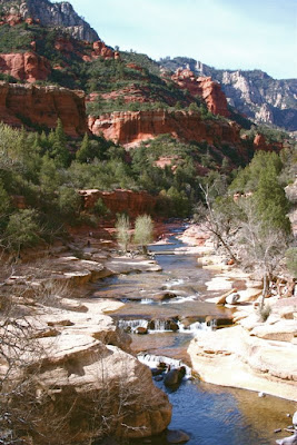
Folks love to lounge on the large red rock platforms near the western end of the park

You would think that our staying within steps of Crescent Moon Park would have tempted us before our last day, but since we had phenomenal views of Cathedral Rock right from our front porch the thought of walking along the creek was not as enticing and you might think.

Still, the park is home to one of the most photographed places in all of Sedona so I knew we would have to make the trek.

Crescent Moon is a picnic area with lovely trees and a creek side walk. The first half of this is paved but the other half is rocky, filled with tree roots, and a few rough areas. I say this from the perspective of my Mother who is not as nimble as she used to be. Anyone under 60 will find the trail quite easy.

Hoodoos at the far eastern end of the trail. Here one is practically on top of the vortex, which is technically on the other side of the creek. These hoodoos were EVERYWHERE.

I found out late in our trip that Cathedral Rock is home of one of Sedona's several vortexes (note, I am not misspelling the word, that is how the locals refer to them). These vortexes are supposed to be centers of concentrated earth energy. Lounging or meditating near a vortex is presumably uplifting. It is certainly a more novel tourist attraction than a curio store and it does have the added benefit of getting people outdoors. A little exercise in the sunshine is always uplifting to me.

One document I found online indicated that the vortex near Cathedral Rock was filled with feminine energy. It is supposed to increase one's compassion and empathy. No wonder I had avoided it all week. My father made a snide remark that I would have to hang out at the vortex for a VERY LONG TIME to see any increase in my feminine side.

Buddha Beach at the end of the trail. Just out of frame to the right was a nice long log for sitting. The hoodoos are also off to the right.

In contrast, I found out there is a masculine vortex up near the airport. No wonder I loved the Ridge Trail so much. The masculine vortex is supposed to increase one's self confidence and ambition. I feel some chest beating is in order!! No wonder I wandered off the trail and climbed down a gully, I was filled with masculine, "it can't happen to me" energy. Hmm, maybe there is something to this vortex thing after all!

Rock rock crossing. I had to stand in the mud with 20 other folks to get this shot.

Crescent Moon park is also a mecca for photographers as I have already mentioned. On this last day, I kept wandering over hoping to catch the sunset on the rocks where they are reflected in the water. By the time things were just getting ripe, a swarm of photographers with their tripods staked out plots of gooey mud along the creek bed each hoping I am sure for that quintessential shot. After a entire week of looking up at this admittedly scenic view, I was less enthused about elbowing in. My best shot of the rock was probably taken from our side yard, which incidentally was home to a meditating local for several days while we were there.

I don't know what she was smoking, but she jousted with invisible demons using a tree branch, swayed to and fro on rather unsteady feet, and finally left her shoes behind when she thankfully departed. One can take the whole vortex thing too far.

Cathedral Rock from our vacation rental.

So this is my final post about my trip to Sedona. I hope you have enjoyed sharing my vacation with me as much as I enjoyed living it. Sedona is a beautiful oasis and I would love to return and hike some of its more challenging trails. Renting a home was a convenient way to share space with several people and it enabled us to cook for ourselves. Some say Sedona is a life-list destination. With so much to do and so much to see, I couldn't agree more.

Sunday, April 12, 2009

Day 6: Andante/Thunder Mountain Loop

Distance: 2.6 miles roundtrip
Elevation: 4,550 to 4,600 ft

Rock spires on the eastern end of Thunder Mountain

On our last day in Sedona, I did not get up and hike early in the morning. I lucked out later in the day, however, because once the thermometer reached a warm 75 degrees, my mother, whom we call Judy of the Tundra, complained of the heat. My father and I dropped her off at our vacation rental, gleefully put on shorts, and headed out to hike.

Andante trail head

I had looked in the book for a short, easy trail that wouldn't over tax him. While the Andante Trail was listed as easy, I would call it moderate simply because it drifted up and down through small gullies that were very rocky.

Dad after an hour in the wilds of Sedona

Andante and Thunder Mountain form a loop if taken together. They exist on the northern side of Sedona, just outside a housing track. The views of the red rocks dominate the scenery but many of the plants and birds also got our attention. There were quite a few Quail, and even a very vocal specimen high up in a shrub, his "head ornament" flapping as his head bobbed up and down. Scrub Jays were also plentiful.

You don't escape from urban life on the Thunder Mountain Trail, but with views like this, do you care?

There are a lot of social trails in the area that gave us pause once in a while, but with the view of Sedona's houses within sight, we didn't have to worry about getting lost in the wilderness.

The trail gets up close and personal to Thunder Mountain itself.

Day 5: Wupatki

Wupatki Ruins

Waupatki is WAY OUT from Flagstaff, a good 30 miles northeast and we almost did not drive there but I am so glad we did. It became my Mother’s personal favorite of all the ruins we visited. The drive itself, while long, is very scenic and is a loop so you don’t have to backtrack that much.

The route goes right by Sunset Crater National Monument, a volcanic cinder cone. My Father really wanted to see this site, but it was so chilly and windy that we only took a short 1/3-mile trail. I have been there before and the 1-mile trail through the lava beds in very interesting.

Sunset crater last erupted between 1040 and 1100, a final hiccup in a long 6-million year history of volcanic activity in the Flagstaff area. The ash and tremors drove the local 400-year old Sinaguan population from the area. They did not return for a 100 years.

Wupatki National Monument contains at least 5 sets of ruins. Finally reaching our limit on ruins, hard to believe I know, we only stopped at the main one. This pueblo sits out on a plain several thousand feet below the plateau that Sunset Crater sits on. In the distance you can see Arizona’s painted desert.

There are two circular structures, which farther north I would call a Kiva, that served as community centers. The pueblo itself is multi-story, which is always fascinating to me. How these peoples, who did not have the wheel, were able to build apartment complexes is quite amazing if you spend more than two seconds thinking about it.

Community Room

The red rocks, blue skies, endless vistas that surround this sight make it a worthy spot if you are in the Flagstaff area.


Looking east out into the Painted Desert

Thursday, April 9, 2009

Day 5: Walnut Canyon Rim Trail

Distance: 1 miles round trip
Elevation: 7,000 ft
Elevation Gain: None

Ruins in an alcove at Walnut Canyon. You can see this set from the Visitor's Center.

Having exhausted all the ruins near Sedona, the family unit decided to head north towards Flagstaff, which is 3,000 feet higher, and quite cooler than its trendier cousin to the south. I have always like the Flagstaff area because of its Ponderosa pines, which smell like my happy childhood summers camping around the west.

We hit two National Monuments near Flagstaff, the first one being Walnut Canyon. I am loath to pass up a tourist attraction, particularly if a new refrigerator magnet can be earned. I hate to say it, but the magnet was the best part of the outing.

The dwelling trail viewed from the Visitor's Center.

Walnut Canyon National Monument contains a series of cliff dwellings that are simplistically constructed into the canyon walls. There are over 300 steps down into the canyon to view the more impressive ones. There was no way my Mother, who had gamely managed to get around thus far, was going to handle that. Instead, we took her out onto the nice viewing platform that angles downward 30 feet or so below the Visitor’s Center. You can see some dwellings from there as well as the canyon floor.

A typical portion of the Rim Trail. You can see a few of the dead trees in the distance. On part of the trail they were everywhere.

We did walk the Rim Trail, which also has nice views of the canyon. There were a lot of dead trees in this area that turned out to be caused by Pine Beetle kill. We saw the tracks and scat of Mule Deer and one Juniper Titmouse that I managed to get a very blurry picture of. There are ruins of a pit house on the Rim Trail that is mildly interesting.

Looking down to the canyon floor. Most of the trees had yet to leaf out.

I don’t think I would drive 300 miles to see Walnut Canyon, but if you are in the area it would make a pleasant excursion. In milder weather, we were quite nipped after Sedona, a leisurely picnic on site would also be pleasant.

Friday, April 3, 2009

Day 4: Slide Rock State Park Vista Trail

Distance: 1 mile round trip
Elevation Gain: Negligible

Standing on the bridge looking up at the park. The water shoot it at the far end of the photo.

We drove up Oak Creek Canyon for a ways after visiting Tuzigoot and Jerome. Oak Creek Canyon is not as spectacular as I thought it would be. It is mostly the creek and trees and not as many red rocks as I anticipated. Most of the trees were barren but I suspect in the heat of summer, those trees and that water would be a welcome respite.


Red rocks along the trail. It was late afternoon and I was shooting into a harsh sun.

One of the most popular areas in Sedona is Slide Rock State Park. Here you can slide through a narrow slot of cool water. In March, it was far too cold to even contemplate getting wet. In fact it was not until the day we left that I could even wear shorts.


Just past the bridge over Oak Creek at the southern end of the park is a parking area and a short trail through the scrub oaks. This trail follows the road back down to the bridge for a nice panorama of the park itself. While short, this little trail is very pleasant. It gave us a chance to view some of the few red rocks in the area.

Another view of the park near the bridge. You can see a few hearty souls playing in the water.

Sunday, March 29, 2009

Day 4: Tuzigoot Sinaguan Ruins

Standing on the roof of Tuzigoot looking north. The light brown near the cliff is the marsh.

Tuzigoot, which is Apache for crooked water is the remains of a Sinaguan pueblo. It also turned out to be my mother’s favorite site on the trip. She liked the idea of seeing an entire village. I liked it because they have reconstructed the roof of the highest part of the structure so you can stand on the top and view the entire area. This might be the viewing loving Coloradoan in me or it might be the fact that the Sinaguans lived on their roofs, and this reconstruction provides a glimpse into that experience.

Looking up at the ruins from the far southern extent of the walkway. There were two gringo women here conducting some faux Indian ritual. The doubt the original inhabitants would have appreciated such misguided beliefs.

This ruin is near Cottonwood, which is 20 miles east of Sedona. We combined this visit with a trip up to Jerome, an old mining village high up Mingus Mountain. Jerome turned out to be such a dud that I won’t bother blogging it. If you go to Tuzigoot, combine it with Palaki and Honaki for a ruins blitzkrieg.

Looking south to the point where I took the previous picture. You can see the green trees and lush farmland of the Verde Valley. It is not difficult to imagine ancient fields covering the entire region surrounding the site.

Tuzigoot sits on a tall ridge that rises 120 feet above the surrounding Verde Valley. About 50 people inhabited the village from 1125 to at least 1400. I would like to see a modern tract home survive that long.

Looking west. Jerome sites on the far hillside. This view is not pristine. In the distance is a copper mine. Most of the ground here is reclaimed from the mine tailings. Who knows what it would have looked like in ancient times.

The Apache name for the site is very apropos. At one point the Verde River actually hooked around the settlement in what is technically called an oxbow. At one point the river broke through the ridge to the south, sending the river away from the settlement. The marsh, which provided both food and reeds to the inhabitants of Tuzigoot managed to survive, fed but a spring.

Interior of the reconstructed tall house. It gives you an idea of the type of construction needed to build multi-story structures.

Saturday, March 28, 2009

Day 3: Honanki Pictographs and Cliff Dwelling

Distance: 0.6 mile loop
Elevation: 4,700 – 4,750 ft
Elevation Gain: 50 ft


If you are going to Palatki, a very nice Sinaguan site, be sure to also visit Honanki. The setting is not as pretty in my mind, but the site does have better, if less historically significant, pictographs. The short trail winds through pine and shrub and was very accessible to my mother who has trouble with stairs. In contrast, she did not climb the stairs to Palatki but stayed just below communing with the lizards on the rocks.

Trail to the Honanki site

You can actually see texture and finger marks in this pictograph

Honanki ruins

Honanki is only 4.4 miles beyond Palaki, but I would recommend setting your trip odometer because that distance is deceiving when you are driving slowly on a dirt road. I kept thinking, gosh that rock formation has got to be it etc. It was not. You will recognize the site immediately and don’t be freaked out when you hit the boundary of the Handcock ranch. The route goes right through it.


The bottom row of images was not visible to the naked eye but became visible when I enhanced the colors of the picture.

One of the local tour companies takes folks to this site, so there were at least 4 tour groups on site. They are small and timed themselves pretty well, so it was not terribly intrusive. I think they are helping to fund the restoration of the area, so you can’t bitch too much about that.

The Sinaguans are gone, but the cliff dwellings are far from uninhabited.

Friday, March 27, 2009

Day 3: Palatki Cliff Dwellings and Pictrographs

Distance: 0.6 miles round trip to view the pictographs, 0.6 miles to walk the cliff dwelling loop for total of 1.2 miles.
Elevation: 4,800-4,850 ft
Elevation Gain: 50 ft.

Palatki Pictographs

If you visit one Sinagua site in the Sedona area, make it this one. The site sits beneath an 800 ft red cliff. It dominates the site and looms dramatically in the distance as one approaches it. The site has both pictrographs and a cliff dwellings but only a one-seater bathroom, so plan accordingly. You will make new friends while standing in line.

Rocks from Road 525

Road 525

You do need reservations to visit. Call (928) 282-3854 for information. The site opens at 9:30 AM but when we called at 9:45 AM we still got a recording. It is Forest Service Volunteers who man the phones and the small visitor’s station, so don’t expect the punctuality one would expect from fully pensioned Federal employees. If you do end up leaving a message like we did be sure to tell them what time you are coming because they will get annoyed if you don’t.

Cliffs around Palatki. The alcove on the left is where the pictographs are located.

Pictograph Trail

There are two ways to get to Palatki. The map you get in town advises driving up 89A towards Cottonwood. From there you need to take Forest Road (FR) 525. Note that there is a small brown sign with this number on it about 50 yards before the turn off. This is the only sign so don’t blink. FR 525 is a long dirt road passable by passenger cars as long as you don’t mind a lot of washboard jiggling. The other way to get there is via Sedona’s back roads, Dry Creek and they Boynton Pass. This is by far the more scenic route and it is paved for longer. I put detailed directions of this route at the bottom of the post. I would recommend going that way, it is just prettier.

Rocks along the pictograph trail

Ancient Scratchings

It was very pleasant out at the site. The pictographs are in two alcoves, each with a docent. The views of the area from these picturesque spots made me wish for a Barcalounger. The ancient Sinaguans understood location, location, location. Just to the left of the pictographs was a spring. So not only did they have protection and beauty, they also had running water.

View from the alcove

Giant Agave Bug (Acanthocephala thomasi). This bug drinks the nectar of the Agave plant, the source of Tequilla. Now that is my kind of meal.

The pictographs at this site are very unusual. There are bears, headless figures, and other unusual anthropomorphic figures. There are also large scratches in the wall that I thought was vandalism but turned out to be ancient and authentic. In the local Indian tradition, shamans would scratch at the walls to enter the spirit world. Some of the pictographs are believed to be several thousand years old.

Pictograph

Palatki Ruins

The trip to the cliff dwelling takes you a across an open field, across a creek, and up some steep steps to the wall. The dwelling itself is not overwhelmingly impressive but the setting is pleasing. We saw a Cardinal and a Scrub Jay on the way back to the car, so there is some wildlife in the area.

Palatki Ruins from the side

There is another site nearby, Honanki, which is not as good but since you are already there, you might as well go see it too. Just be prepared for the hordes. One of the local jeep touring companies takes folks to that site. Don't pay money for that trip, however, you can get there easily by yourself.

Directions (the more scenic route): Drive 2.9 miles up Dry Creek Road out of Sedona to the Long Canyon intersection. Stay left and drive another 1.6 miles to the Boynton Canyon intersection. Go left and drive another 4 miles to the intersection with Forest Road 525. 2 miles of this last pitch are on a dirt road. The dirt continues to the site. 0.1 miles from the 525 intersection is a fork. The right fork goes to Palatki, the left to Honanki. It is 1.7 miles on the right fork to the site.

Wednesday, March 25, 2009

Day 2: Tlaquepaque

Shopping shopping!!


Who can resist picking up some bling from the southwest? I certainly can't! The most attractive place to shop in Sedona is the Tlaquepaque (pronounced Tal-keh-paw-keh) Arts and Crafts Village. It is modeled after a mexican villiage and was orginally conceived as an artist colony. Now it is filled with galleries and shops. It is the ambiance, however, that is the most striking. Filled with bronze scultures, fountains, balconies, and ecentric sycamore's, Tlaquepaque is a very pleasant environment indeed!


My second cousin, who lives in town, said she can spend the entire day there. I managed to spend 2.5 hours, which is a lot for this gal who would rather be hiking than shopping. Still, I managed to find a nice tourquoise inlaid ring that I am very pleased about. My father, who is not much of a shopper, moved from bench to bench and photographed the scenery. Below are a few quick shots to give you an idea of the place.


North Rock Creek Snowshoe

Distance: 4 miles round trip Elevation: 9,180 ft to 9,780 ft Elevation Gain: 600 ft Dogs: Off leash until the wilderness boundary North...