Showing posts with label snowshoe. Show all posts

Wednesday, February 2, 2022

North Rock Creek Snowshoe

Distance: 4 miles round trip
Elevation: 9,180 ft to 9,780 ft
Elevation Gain: 600 ft
Dogs: Off leash until the wilderness boundary


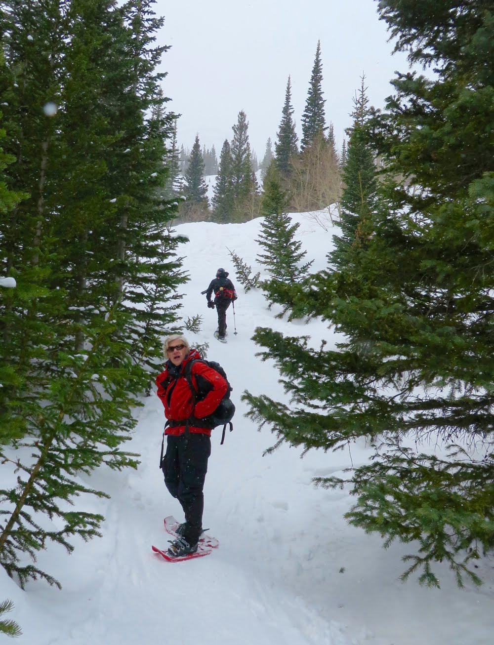
North Rock Creek, near Silverthorne, CO is in the lesser-used area and is one of the many trails that head west from Highway 9 and into the Eagles Nest Wilderness. With a little bit of everything, it has a lot to offer. There are sweeping views of Ptarmigan Peak and Old Baldy to the east, some huge Aspen groves, an expansive meadow, and lot of “peak”-a-boos to the west. For both the snowshoer and the skier, this trail is very easy. There are a couple of short hills to ascend, but nothing major. If you are new to snowshoeing, give this one a try.

To start, head up Rock Creek Road, a plowed road right across from the Blue River Campground on Highway 9. The plowed section ends right before the large switchback you see on the topo map. There is medium-sized plowed parking area on the left marked by a sign that says Rock Creek Trailhead. Don’t be confused here. The road actually heads sharply up behind this parking area while a more prominent spur road continues due west. This road is not on the map, so it may easily be confused with the main route. It dead-ends shortly at a gate for some private homes.

After a series of switchbacks, the trail straightens out and heads due west. The first mile is open and filled with young Aspens. 

There are several easy milestones on this trail to keep you aware of your distance. It is 1.5 miles from the winter parking area to the summer trailhead. 0.1 miles beyond that is the boundary for the Eagles Nest Wilderness. 0.3 miles beyond the wooden wilderness sign is the intersection with the Gore Range Trail, which is prominently marked by another wooden sign. We always take a group of novice snowshoers out early in the season. In the past, we have chosen Peru Creek for its wide road and easy grade. Rock Creek may supplant Peru Creek because of it constant rewards.

5 reasons to snowshoe Mayflower Gulch this winter. Number 4 is for badasses.

Mayflower Gulch near the Copper Mountain Ski Resort is by far one of the best snowshoes in Colorado and it is within an easy drive of five major ski resorts. Here are five reasons you should not pass up this phenomenal adventure:

Heavy snow years means an "up the gut" exploit

While most people get to Mayflower Gulch by snowshoeing up the well traveled road through the trees, in years when there is plenty of snow, you can travel up the open valley to the left of the road. This adventure will take you over buried willow shrubs and around rock formations with a never ending view of the mountains ahead. Going "up the gut" will make you grin. People pay big bucks for this sort of thing.

A close up of the ridgeline

Mayflower is free, accessible, and close to what matters

Unlike Vail Pass with its ridiculous winter fees, Mayflower Gulch is totally free. There is a large parking lot at the trailhead that can hold a hundred Subaru Outbacks plus the odd RV. Only seven miles up Hwy 91 from Copper Mountain, it is also close to Frisco, Silverthorne, Keystone and Breckenridge. Talk about bang for the buck!

Whipped cream snow, crenelated peaks, and post card blue skies

The snow in Mayflower Gulch is special. I don't know if it is the wind, the sun, or just magic but the snow always seems to drape the surrounding features like globs of Cool Whip. You will want to eat it, wear it, and otherwise frolic in it. It is just so damned precious. Add to this an amphitheater with jagged peaks beneath high-altitude darkened blue skies and you have a winter tableau worth a million bucks!
Whipped cream anyone?

"Cornice of the buried dead"

On the right hand side of the bowl is a large snowfield over which hangs a cornice formed by the persistent winds blowing north from Leadville and Colorado's highest peak, Mt. Elbert. This cornice is big, bad, and nasty. It persists well into the spring but in winter creates the ultimate skiers challenge. I have observed the hearty stomping on it before launching themselves, their screams of joy only mildly dampened by the surrounding peaks. I have slogged up and over this cornice to wonder and the layers of mountains in the distance. Are you bad ass enough to try it.

The cornice
Passing skiers about to tempt the cornice
Climbing along the cornice

A back bowl of waist deep snow will make your cardiologist proud

It is only a short two miles from the parking lot to the ruins of the old Boston mine, which sits at the bottom of the gulch. Most folks stop here and sip spiked drinks from steaming thermoses. The fit can continue on towards the back bowl, however and earn bragging rights. There is trail around the right...a road in summer, that ends at a two-story mining ruin. Skiers often take that route. I am fond of slogging straight up the hill to the left. The snow is deep...which is great for return tumbles and face plants. On the way up however, you might just exhibit a gasp or two. The Boston Mine sits at 11,500 ft, after all, an altitude likely to remind you that doing turns at Keystone is not the same as conquering this mountaineering StairMaster.  

The back bowl


Vital Statistics

Distance: 3.4 miles round trip to the Boston Mine, 6 miles round trip to Gold Hill
Elevation: 10,996 ft -11,520 ft (Boston Mine) – 11,980 ft (Gold Hill).
Elevation Gain: 580 ft to the Boston Mine, 1,040 ft total to Gold Hill
Dogs: Off leash
Bathroom at Trailhead: No
Tags: #snowshoe #winterwonderland #BYO2 #photographersparadise #yehsnow

Mining ruins and the crenelated spires of Mayflower Gulch.

Sunday, January 7, 2018

North Trail Snowshoe (Red Sandstone Road West)

Distance: 4 miles round trip
Elevation: 8,240 ft - 9,040 ft
Elevation Gain: 800 ft (net) 919 ft (cumulative)
Bathroom at Trailhead: No
Dogs: On leash but many off
Tags: #snowshoe, #winter, #coloradooutdoors, #vail

A typical segment on the North Trail...this time looking back to the east and a hillside covered with Aspens. 
North Trail, across the valley from the Vail Ski Resort, is 11.5 miles long but with parking lots interspersed every 3 to 4 miles, you can easily break it up into segments.  On this trip we started at the parking lot on Red Sandstone Road and headed west.

Map of the entire North Trail
Trailhead
In all honesty we did not even know that this trail existed until we decided to try and snowshoe up Red Sandstone Road out of Vail. In looking at the trail map we noticed North Creek and ended stopping at the trailhead on our way up just out of curiosity. When we discovered that Red Sandstone Road was 100% snowmobiles, as evidenced by the caravan of trucks and trailers parked all along the road, we decided to try the North Trail instead.

Looking south on an early switchback 
Looking at Red Sandstone Road and Vail 
This segment of the North Trail switchbacks and switchbacks up the north side of Vail Valley in an seemingly endless procession. In fact the switchbacks are really only about a mile and the views of Vail are rather revealing. At 1.5 miles the trail entered a beautiful and extensive Aspen Grove (fall hike anyone?) that is deep within a quiet crenelation further from the noise of I-70.  For a short hike this would make a suitable destination although there was no place to sit down. We decided to continue for another half mile to see where the trail led and ended up eating lunch on a nice log protruding from the snow with views of Mt. Holy Cross to the south and the Gore Range to the east.

The view from an upper switchback
Looking back to the east.  Note the narrow trail and steep hillside. 
It was obvious from the well packed trail that this route is popular with the locals. Because of the steepness, and narrowness of the route, we wore our Microspikes, which had all the grip we needed.  Do not attempt this trail without some sort of gripping footwear or you will slide down the hillside faster than a gold-medal winning toboggan team!

The Aspen Grove at 1.5 miles
The view of the Gore Range from our lunch spot at 2.0 miles
While not a wilderness experience, this trail was fun and practically balmy on a sunny day. We saw only two people the entire time.  I will have to check this trail out in the fall.  Note that the trail is closed from April 15th - June 15th for wildlife preservation.

Below is a shameless ad for the Microspikes we wore on this trip.  They really are a winter essential.

Saturday, February 4, 2017

Sourdough South Snowshoe

Distance: 5.4 miles round trip
Elevation: 9,252 ft - 10,053 ft
Elevation Gain: 838 ft (cumulative)
Bathroom at Trailhead: Yes
Dogs: Off leash
Tags: #snowshoe, #coloradooutdoors

Trailhead
The Sourdough Trail north of Nederland on Highway 72 is a popular spot for local winter enthusiasts who don't mind the crowds or limited views. The trail is actually quite long, traversing from County Road 116 in the south to County Road 112 (Brainard Lake Road) in the north. This post profiles a southern segment from the trailhead to the Peace Bridge over Four Mile Creek at 2.7 miles one way.

Map of the route. Star at the end marks the location of the Peace Bridge.
Sourdough is mostly in the trees
The Sourdough trail ascends rather gradually at first but then turns sharply upwards at 0.8 miles where the route makes a sharp left turn at an open vista of Niwot Mountain. At 1.4 miles the route crosses an open road and at 1.9 miles there is a large sign marking the trail. There are two small drainages that are crossed that can be easily seen on the map. The bridge itself is located at the bottom of a deeper drainage and may be obscured by snow. The sign for it can only be seen from the other side. The terrain is in the trees most of the time, which can provide shelter on a blustery day.

Rare "peak-a-boo". Mt. Niwot
Old sign at 1.9 miles
While the parking lot is large and is split into three fingers, it still fills up rapidly on winter weekends, so plan accordingly. The trailhead is located across the road from the parking area and is marked by a large kiosk.

Last downhill pitch to the bridge
To get to the trailhead, travel north on Highway 72 out of Nederland for approximately 8 miles and then turn onto County Road 116. CO Rd 116 is plowed but will be snow packed. The parking lot is located a quarter of mile or so on the left.

Peace bridge
The official sign is only visible after crossing the bridge

Saturday, January 21, 2017

Pioneer Union Ditch Snowshoe

Distance: 5 miles round trip
Elevation: 9,971 ft to 10,597 ft
Elevation Gain: 626 ft
Dogs: Off leash
Bathroom at Trailhead: No
Tags: #snowshoe, #coloradooutdoors
Nearby Snowshoes: Hefferman Gulch Road

Rare "peak-a-boo" along Pioneer Union Ditch
Pioneer Union Ditch near Idaho Springs is a great place to snowshoe if you hate the hordes, love the seclusion of the trees, and don’t mind finding your way. It spends only 0.7 miles on a well-defined path before diving off into a deep valley filled with interlocking mining roads.

Map showing the route up Pioneer Union Ditch

Leaving Leavenworth Road and heading into the Pioneer Union Ditch

The trail begins on north side of Guanella Pass and starts up Leavenworth Creek Road, which heads towards the Waldorf Mine. There was no street sign for this road, but it occurs at the first major switchback coming up from Georgetown. Within 0.7 miles, the route leaves the road, which continues sharply upwards towards the right, and instead dives into Pioneer Union Ditch, following old mining roads that hug the valley floor.

Hard packed snow, dogs and trees.
Typical segment along a road and in the trees
Since this is a valley, it is actually hard to get lost. Persistent power lines head west and Leavenworth Creek Road is 200 yards and several hundred feet above on the right.

Crossing a more open area
Creek Crossing
There is little or no mountain scenery on this trail, but there are Aspens, meadows, and the sound of a crackling brook. On this trip, there was little to no snow for the first 1.5 miles but after that, it picked up. Most of the elevation gain is in the first mile.

Heading back down on Leavenworth Creek Road
While we decided to turn around at 2.5 miles Pioneer Union Ditch continues to parallel Leavenworth Creek Road for miles and miles. As an alternative it is about 6 miles (one way) to the Waldorf Mine.

Friday, February 19, 2016

Rock Creek Snowshoe

Distance: 4.5 miles round trip
Elevation: 8,765 ft - 9,896 ft
Elevation Gain: 1,131 ft (net),  1500 ft  (cum)
Dogs: Off leash
Bathroom at Trailhead: No
Tags: #snowshoe, #coloradooutdoors, #allenspark

Rock Creek Road near Allenspark, CO
Rock Creek Road near Allenspark, CO is great place to snowshoe if you don't like crowds and don't mind the occasional snowmobile. Rock Creek Road (or FSR 1162) starts at the end of Ski Road (CO 107) where it meets FSR 1161 (St. Vrain Trailhead). After an initial decent, the road heads relentlessly upwards before dead ending just below a saddle between two 11,000 foot peaks. From the road you won't see any of these peaks but you will see towering spruce trees and a snow covered creek that gurgles pleasantly along the route.

Terrain map of the area
Parking for this snowshoe is limited, but rarely used.  A few cars can park on the edge of FSR 1161 and three to four more can park along Ski Road itself, which as a county road is usually plowed.

Looking back on a more open area towards the beginning of the route.
From the parking area, the route descends until it crosses a creek and then begins a slow climb upwards. Depending on conditions, the road can be iced over, filled with fluffy drifts, or bare in spots. It is used by local skiers who cruise up and down in marathon laps.

Rocks and Aspens 
Starting out there are campsites along the left hand side of the road while rock formations and aspens dominate the hillsides to the right. At 1.2 miles (640 ft gain) is a wooden fence near a creek crossing. Only a tenth of a mile beyond this is the first switchback and 1.75 miles is the next switchback (973 ft gain). It is two miles to a small meadow.

A more open area
The further you ascend the larger the trees seem to become. The road itself becomes more narrow so the trees begin to close in creating a mystical tableau.

Ice free area of the creek
While Rock Creek will not wow you with views, it usually has snow and is off the beaten track. Its steady ascent will give you a work out to boot.

Towering trees near the upper reaches of the road

Sunday, January 10, 2016

Loch Vale + Mills Lake Snowshoe

Distance: 5.4 miles round trip (4.4 round trip to the Loch Vale only)
Elevation: 9,200 ft - 9,940 ft (Mills Lake), 10,258 ft (Loch Vale)
Elevation Gain: 1,137 ft (Loch Vale) 1,400 ft (both lakes)
Bathroom at the Trailhead: Yes
Dogs: Not allowed, National Park
Tags: #coloradooutdoors, #snowshoe, #rmnp, #winter

Loch Vale in Rocky Mountain National Park 
Mills Lake
If your mother was a Yeti, then you'll enjoy snowshoeing in Rocky Mountain National Park. I don't know what it is about this area, but while skiers on the other side of the Continental Divide can be basking in blue skies and mild conditions, snowshoers in the park will be blessed with churning vortices of snow that mask the peaks and drive all but the hardiest into hibernation.

Parking lot at Glacier Gorge in Rocky Mountain National Park
To add to the fun, the winter trails in this part of the park are very different from the summer trails and unmarked to boot. Do not attempt this unless someone has already forged a trail for you or you are really good at reading terrain. Examine the map below. The summer trail is marked on the map as a grey line while the winter trail is indicated with red arrows. The trick is finding the location of where the two split from each other.

Terrain map showing the summer trail (grey line) and the winter route (red arrows). 
The summer trail, for those who have done it, winds up a series of switchbacks and then skirts along a shelf looking down into Glacier Gorge until Glacier Junction, the intersection of the trails for Loch Vale, Mills Lake and Lake Haiyaha. The winter trail skips this entirely. It starts out following a drainage, turns left around East Glacier Knob before arriving at Glacier Junction (at 1.4 miles). From this point the winter trail to Mills Lake is close to the summer trail. The route to the Loch Vale however stays in the drainage and actually climbs up what is a waterfall in summer.

Starting out
Once off the summer trail and onto the drainage, the route wanders in and out of trees. It is strange to think there may actually be 10 feet of snow between you and the frozen stream below. As the season warms, sink holes form above the water creating the opportunity to fall in without a trace.

Rock face
Starting out in the trees
On this trip we went to the Loch Vale first (2.2 miles one way), so after hitting Glacier Junction, we turned right at the hitching post, barely visible in the drifts, and headed up the lake's drainage. This part of the route is a calf-killing climb in the best of years but earlier in the season or in a season with little snow, can be death defying. March is a great time to do this route because there is generally more snow and the temperatures are not so daunting.

Parts of the route can be very thick with snow
Along the sides of the drainage, icicles the size of surf boards dangle from the walls. This is not a route suited for skiers, however, who may find the steepness and vicinity of bone crushing protuberances a bit risky.

Heading up the waterfall
Climbing over the lip of the drainage/waterfall is a life changing experience. In early winter the lake is host to preternatural winds that will freeze the eyeballs in your head and they hit you the moment you arrive. It is still another hundred and fifty yards to the edge of the lake, so have your baklavas and goggles handy. If you are lucky, you'll see the lake and not remain frozen there until spring. If you are not lucky you will assume the lake is there and beat a hasty retreat. Be advised that as cold as it is, the water near the shore may or may not be totally frozen. On at least two trips we rescued hapless snowshoers who had fallen through the ice.

The Loch Vale on a typically lovely day in winter.
The return route is straight back down the drainage, which is amazingly steep in retrospect. Near the bottom veer off to the right and search for the large frozen waterfall that hangs precipitously over the cliff face. The ice here is large, usually tainted brown, and braced by a slope of deep snow. Bushwhacking in deep snow may be required but the view will be worth it.

Climbing up to the frozen waterfall 
To get to Mills Lake, retrace your steps to Glacier Junction and then follow the other tracks away from your original route. Again, this is not a place to get lost in so hopefully someone else will have tracked the route in advance.

Frozen Mills Lake

What I like about Mills Lake in winter is the pile of driftwood that covers is lower end. These skeletal remains lie tumbled amid drifting snow, a harsh and picturesque reminder of the severity of nature. Think of the Elk, the deer, and the Marmot, existing upon that frozen tableau, and then think about your heating blanket, double espresso maker, and fire place. Count your blessings that you are a Primate!

Frozen logs at the end of Mills Lake
The soul needs a reboot once in a while; so don’t let my description deter you from venturing out on this lovely trail. It is a unique experience. Just take care that the trails are tracked and that you are prepared for changing weather conditions.

North Rock Creek Snowshoe

Distance: 4 miles round trip Elevation: 9,180 ft to 9,780 ft Elevation Gain: 600 ft Dogs: Off leash until the wilderness boundary North...