Showing posts with label Loch Vale. Show all posts

Sunday, January 10, 2016

Loch Vale + Mills Lake Snowshoe

Distance: 5.4 miles round trip (4.4 round trip to the Loch Vale only)
Elevation: 9,200 ft - 9,940 ft (Mills Lake), 10,258 ft (Loch Vale)
Elevation Gain: 1,137 ft (Loch Vale) 1,400 ft (both lakes)
Bathroom at the Trailhead: Yes
Dogs: Not allowed, National Park
Tags: #coloradooutdoors, #snowshoe, #rmnp, #winter

Loch Vale in Rocky Mountain National Park 
Mills Lake
If your mother was a Yeti, then you'll enjoy snowshoeing in Rocky Mountain National Park. I don't know what it is about this area, but while skiers on the other side of the Continental Divide can be basking in blue skies and mild conditions, snowshoers in the park will be blessed with churning vortices of snow that mask the peaks and drive all but the hardiest into hibernation.

Parking lot at Glacier Gorge in Rocky Mountain National Park
To add to the fun, the winter trails in this part of the park are very different from the summer trails and unmarked to boot. Do not attempt this unless someone has already forged a trail for you or you are really good at reading terrain. Examine the map below. The summer trail is marked on the map as a grey line while the winter trail is indicated with red arrows. The trick is finding the location of where the two split from each other.

Terrain map showing the summer trail (grey line) and the winter route (red arrows). 
The summer trail, for those who have done it, winds up a series of switchbacks and then skirts along a shelf looking down into Glacier Gorge until Glacier Junction, the intersection of the trails for Loch Vale, Mills Lake and Lake Haiyaha. The winter trail skips this entirely. It starts out following a drainage, turns left around East Glacier Knob before arriving at Glacier Junction (at 1.4 miles). From this point the winter trail to Mills Lake is close to the summer trail. The route to the Loch Vale however stays in the drainage and actually climbs up what is a waterfall in summer.

Starting out
Once off the summer trail and onto the drainage, the route wanders in and out of trees. It is strange to think there may actually be 10 feet of snow between you and the frozen stream below. As the season warms, sink holes form above the water creating the opportunity to fall in without a trace.

Rock face
Starting out in the trees
On this trip we went to the Loch Vale first (2.2 miles one way), so after hitting Glacier Junction, we turned right at the hitching post, barely visible in the drifts, and headed up the lake's drainage. This part of the route is a calf-killing climb in the best of years but earlier in the season or in a season with little snow, can be death defying. March is a great time to do this route because there is generally more snow and the temperatures are not so daunting.

Parts of the route can be very thick with snow
Along the sides of the drainage, icicles the size of surf boards dangle from the walls. This is not a route suited for skiers, however, who may find the steepness and vicinity of bone crushing protuberances a bit risky.

Heading up the waterfall
Climbing over the lip of the drainage/waterfall is a life changing experience. In early winter the lake is host to preternatural winds that will freeze the eyeballs in your head and they hit you the moment you arrive. It is still another hundred and fifty yards to the edge of the lake, so have your baklavas and goggles handy. If you are lucky, you'll see the lake and not remain frozen there until spring. If you are not lucky you will assume the lake is there and beat a hasty retreat. Be advised that as cold as it is, the water near the shore may or may not be totally frozen. On at least two trips we rescued hapless snowshoers who had fallen through the ice.

The Loch Vale on a typically lovely day in winter.
The return route is straight back down the drainage, which is amazingly steep in retrospect. Near the bottom veer off to the right and search for the large frozen waterfall that hangs precipitously over the cliff face. The ice here is large, usually tainted brown, and braced by a slope of deep snow. Bushwhacking in deep snow may be required but the view will be worth it.

Climbing up to the frozen waterfall 
To get to Mills Lake, retrace your steps to Glacier Junction and then follow the other tracks away from your original route. Again, this is not a place to get lost in so hopefully someone else will have tracked the route in advance.

Frozen Mills Lake

What I like about Mills Lake in winter is the pile of driftwood that covers is lower end. These skeletal remains lie tumbled amid drifting snow, a harsh and picturesque reminder of the severity of nature. Think of the Elk, the deer, and the Marmot, existing upon that frozen tableau, and then think about your heating blanket, double espresso maker, and fire place. Count your blessings that you are a Primate!

Frozen logs at the end of Mills Lake
The soul needs a reboot once in a while; so don’t let my description deter you from venturing out on this lovely trail. It is a unique experience. Just take care that the trails are tracked and that you are prepared for changing weather conditions.

Monday, November 22, 2010

Loch Vale Hike

Distance: 6 miles round trip
Elevation: 8,787 ft - 10,220ft
Elevation Gain: 1,433 ft
Critters: Stellar's Jay
Tags: #rmnp, #coloradooutdoors, #hike, #mountainlake

Loch Vale in Rocky Mountain National Park

Loch Vale is a classic hike in Rocky Mountain National Park that many visitors do on their summer vacations. It is relatively easy, has interesting milestones along the way, and ends at a spectacular lake. It is suitable for beginning hikers.

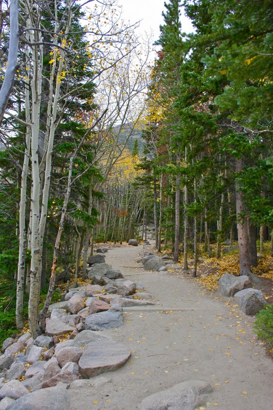
The well groomed trail starts out in a grove of young Aspens.
The trail follows Glacier Creek, which is particularly attractive in the fall.

Another trail segment
The trail to Loch Vale begins at the Glacier Gorge Trailhead. At 0.9 miles is Alberta Falls, which rages in the spring and is frozen over in the winter. Tourists gather about the rocks snapping pictures of themselves. Be sure to stop here and look down into the gorge as well. This part of the trail is broad and well manicured. It winds through juvenile Aspens and conifers.

Alberta Falls
Above Alberta Falls, the trails switchbacks up the hillside until it enters Glacier Gorge, a wind tunnel filled with stunning rocks and "peak-a-boos". Along the way are large pull outs for landscape photography.

Looking north from one of the many view points along the trail to Glacier Gorge
At 2.23 miles is the junction with Mills Lake and Lake Haiyaha. From this point, the trail heads up a series of switchbacks with views of the gorge. The switchbacks are not long or arduous. At the top is Loch Vale. There is a trail that circumnavigates the lake and lots of "beaches", rocks, and peninsulas to lounge on.

The left side of the Glacier Gorge
Looking up Glacier Gorge
In the winter, this spot is one of the coldest in Colorado, but on this trip in early October it was balmy. My friend and I sat by the lake and ate lunch. An aggressive Stellar's Jay kept us company and ogled our sandwiches.

Heading up the switchbacks to the Loch Vale

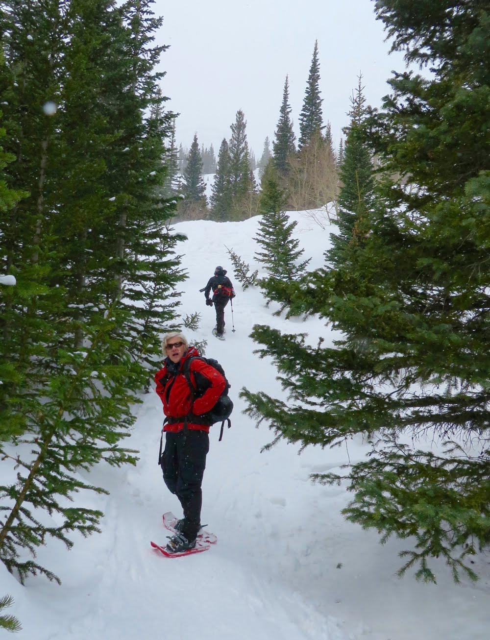
Looking up the Gorge that we snowshoe in winter. Those boulders are much larger than they look.

If you are visiting Rocky Mountain National Park, add this trail to your list. It won't disappoint. Add one mile to your trip and visit Mills Lake on the way back. From the LochVale/Mills trail junction it is a short 0.5 miles and minimal elevation gain to Mills.

Wind blown Bristlecone Pines on a peninsula jutting out into the lake

North Rock Creek Snowshoe

Distance: 4 miles round trip Elevation: 9,180 ft to 9,780 ft Elevation Gain: 600 ft Dogs: Off leash until the wilderness boundary North...