Showing posts with label hiking. Show all posts

Friday, September 15, 2017

Twin Sisters

Distance: 7.4 miles round trip
Elevation: 9,090 ft  – 11,430 ft
Elevation gain: 2,340 ft
Bathroom at Trailhead: yes across the road at Lilly Lake
Tags: #RMNP, #coloradooutdoors


Twin Sisters viewed from Hwy 7
Twin Sisters on the east side of Rocky Mountain National Park is a great trail that has elevation gain, panoramic views, and proximity to the Front Range. Its large rocky summit, with multiple piles of scree, will make you feel like you have climbed a 14er without busting a lung.
Lily Lake, located across the road from the trailhead
While in a mixed forest for most of the way, the trail does have periodic views of the Mt. Meeker, Longs Peak, and Mt. Lady Washington, which are located right across the valley. The density of the trees themselves is thin, which at least creates a sense of airiness. Finally, the entire route is strewn with angular rocks that were coated with chartreuse lichens. They are so bright, you'll be reminded of Graceland. Long live chartreuse.

Longs massif viewed from the trail. From left to right is Mt. Meeker (13,911 ft), Longs Peak (14,255 ft), and Mt. Lady Washington (13,281 ft).
Despite its daunting elevation gain, the route is not difficult. The ascent is accomplished through a long series of switchbacks with few large step-ups. Very little quadricep action is required. Flatlanders in tennis shoes were easily navigating the trail although boots with ankle support will protect you  from the small, angular rocks which can easily cause twists, particularly on the descent.

A typical section of tree "encrusted" trail
Rocks and green turf near treeline
The view from treeline looking towards the summit ridge
There is a very interesting transition near treeline when large twisted rock formations come into view. These formations are bordered by stones jutting out of the turf and by Limber Pines, which have been sculpted by the wind into bent, twisted silhouettes.

Looking back down the trail
Just beyond these trees, there is a portal into the world of sun, wind, and stone. Within the span of two footsteps you suddenly travel from a forested realm into a long bare rock field. You might want to turn around here to make sure the doorway is still there. I half expected to find a dragon perched nearby or at least an ogre or two.

Another shot looking back down the trail
It is 0.75 miles from this transition line to the summit. The views of Estes Park and beyond will make you stumble as you try to navigate the rocks and ogle the view at the same time. A long pitch along the ridge and a series of short switchbacks takes you to a large saddle surrounded by two large domes of scree. The one to the right, next to the park’s radio tower, is where most people end up. The views there of the Longs' massif will boggle the mind.

View of the summit
The summit is a great place to watch clouds form. At one point, directly over the lower dome we could actually see tendrils of air curl and wind their ways upwards only to be consumed by an even larger cloud. I have a theory about Twin Sisters. It has a large, exposed block of scree, and I wonder if the heated rocks provide extra lift near its summit. Even when I have not been on the summit, I have seen large storms form right on top of it. Who knows if this is true, but the wary hiker of Twin Sisters should get an extra early start.

View of the Longs' massif from the summit
If you have the chance to visit this trail, you won’t need your park pass but you might need a few weapons of mass destruction since it does seem to be popular with folks who look like they just stumbled out of the Winnebago. You would think that the altitude gain would deter most of these visitors, but it does not.

Looking northwest from the summit
The trailhead is located on Hwy 7 between Estes Park and Allenspark. There is a parking lot across the road at Lily Lake, which has a bathroom or you can drive directly to the trailhead up a short dirt road. Parking in this lot is more limited.

Wednesday, April 20, 2016

South Boulder Peak via Shadow Canyon

Trail Length: 6.7 miles round trip
Elevation: 5,645 ft - 8,549 ft
Elevation Gain: 3,039 ft
Critters: Mountain Blue Birds
Bathroom at Trailhead: Yes
Dogs: Off leash with OSMP voice and sight tag
Date Hiked: March 2008
Tags: #boulder, #osmp, #peak, #hiking, #coloradooutdoors

Looking north towards Green Mountain from the summit of South Boulder Peak 
Climbing to the summit of South Boulder Peak in Boulder, Colorado is an arduous adventure that is like climbing a 14er without the altitude. The lower part of the route is on dirt trails, but the last half is up the slopes of Shadow Canyon, a rock filled gorge that will require some route finding and rock scrambling skills.

Note in 2013, a small fire on the top of the peak burnt most of the trees on the summit as well as the saddle below. 

Heading up the Homestead Trail
The ascent via Shadow Canyon begins at the Eldorado Canyon/Mesa Trail trailhead. The hiker can ascend the Homestead, Towee, or Mesa Trails to the base of Shadow Canyon. This trip we chose the Homestead trail because it was a bit steeper (for maximum pain) and dogs are allowed on it off leash.

The Homestead Trail briefly intersects the Towee trail before it runs into the fire road, near the ruins of the Debacker cabin that leads Shadow Canyon. The road switch backs upwards and in its final curve to the north, dead-ends at the base of the canyon itself near the ruins of the Stockton Cabin with its large section of water pipe. This is where the trail gets interesting.

A typical trail segment in Shadow Canyon.  Narrow, rocky,  and straight up. 
From this point on, the route ascends upwards 1,620 ft in one roughly one mile. The trail is dark with pine, encrusted with boulders and scree, and poorly defined. In early spring, the trail can be covered in a mix of snow and black ice. 

There are no views per say in the canyon itself except for glimpse of the Devil’s Thumb along the right wall about a third of the way up, and of valley below from the switch backs that start about two thirds of the way up. The saddle itself is flat and covered in more Ponderosa and Lodgepole pine. 

One of the only viewpoints on the trail
From the saddle, you can go to the east and ascend and additional 281 ft in 0.3 miles to Bear Peak or head to the west and ascend an additional 369 ft in 0.2 miles to South Boulder Peak. The summit is a small scree field with lots of nooks and crannies. The views from the peak are expansive but watch out for storm clouds, which have a habit of building on top of these peaks. 

Sunday, December 12, 2010

Pella Crossing

Distance: 1.5 mile loop around Sunset Pond and Heron Lake
Elevation: 5,095 ft
Elevation Gain: None
Critters: Water fowl
Dogs: On leash (this is a Boulder County Open Space Park)

Looking west from the far end of Heron Lake in the Pella Crossing Open Space Park

Pella Crossing is a lovely open space park near Hygiene that is popular with runners, birders, and fishermen. In October, I took my parents there on an afternoon stroll. I took a picture every few feet and every one was a keeper.

Map of the Open Space Park. We took the route counter-clockwise. The inset in the upper right of the maps shows the lakes on the other side of N 75th St.

Faded Yellow Rabbitbrush (Chrysothamnus viscidiflorus) clings to the side of Sunset Pond

A panoramic view. I don't know what this area is like in the spring, but in the fall, it is sublime.

The entire route is as wide, flat, and appealing as this shot.

The area consists of several adjacent lakes with a well-groomed, handicapped-accessible trail that winds around them. Open fields and Cottonwood trees line the route and skydivers were seen jumping from a plane overhead to land in a nearby airport.

Sun glints through a very large Narrowleaf Cottonwood (Populus angustifolia )

A seed pod from the Common Milkweed (Asclepias syriaca) cracks open in the warmth of the Indian Summer sun.

The fibers of the Milkweed plant were used in WWII to stuff life preservers and are now used in many other products since it is better than down in insulating properties.

Fishing for Large Mouth Bass is encouraged and belly boats are common. There are actually 5 lakes, 3 on the east side of N. 75th Street and 2 on the west side. We only walked around the lakes on the east side (Sunset Pond and Heron Lake), but a longer route is possible by crossing over and walking the other side.

The back side of Sunset Pond

Long's Peak (14,259 ft) is barely visible through the clouds that hang over the mountains.

Fisherman in a belly boat drifts serenely on the west end of Sunset Pond. The lazy movement of his fins did not disturb the glass-like surface of the water.

Monday, December 6, 2010

Alluvial Fan Nature Hike

Distance: 0.5 miles
Elevation: 8,557 ft - 8,640 ft
Elevation Gain: 83 ft

In the center of the Alluvial Fan

The Alluvial Fan is a short but scenic trail in Rocky Mountain National Park suitable for elders and children. The trail crosses an area of waterfalls, boulders, and Aspens that formed when the Lawn Lake Dam broke upstream on July 15, 1982. Shortly after 5:30 AM, water and debris tumbled down the Roaring River Valley. People camping along the river reported that the water rose 22-30 ft. One camper in this area was killed.

Fall color amongst the rocks

As the water exited the narrow river valley and spread out into Horseshoe Park, it overran a campground and killed a few more people. Logs, house-sized boulders, and sand was dumped into a large pile.

Looking at the debris from the west side

The water then traveled toward the town of Estes Park, the gateway community to Rocky Mountain National Park. It took out a small hydroelectric power plant and fish hatchery before sending a river of mud through the downtown area. Finally, the water flowed into the Big Thompson River and dumped into Lake Estes. Total cost of the accident was $31M.

The river is much calmer now

Today, a walk across this debris field is both scenic and sobering. Tourists gather amongst the rocks, water either roars or trickles through the area depending upon the season, and trees have grown up along the edges. The route has minimal elevation gain and winds through the debris. It is 0.5 miles between the east and west Alluvial Fan parking lots and roughly 0.25 miles from either lot to the center of the fan. From the top of the mound there are also great views of the Endovalley/Horseshore Park area.

Tuesday, November 9, 2010

Devils Causeway Hike

Distance: 6.0 miles round trip
Elevation: 10,298 ft - 11,608 ft
Elevation Gain: 1,721 ft
Dogs: Voice and Sight Control (Flat Tops Wilderness)
Date Hiked: 21 Sept 2010
Tags: #hiking, #coloradooutdoors, #FlatTops, #gearguide
Other Trails in the area: Trapper's Lake, Skinny Fish Lakes, Flat Tops Scenic Drive
Topo Map: Flat Tops
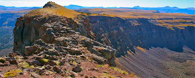


The Devil's Causeway is a small eroded spit of land connecting two ridges.  While those without a fear of heights can just walk across, most other humans cower before it. The Devils Causeway

Devil's Causeway is one of the most notorious hikes in Colorado. This hike, which ascends the Chinese Wall in the Flat Tops Wilderness, contains a narrow 3-foot wide, 25-yard long segment of broken rock with 1,500 ft drops on either side. This segment, which gives the trail its name, is demonic indeed. Anyone with the slightest bit of acrophobia will cower, cringe, and otherwise drool on themselves with anxiety. The pictures of this chunk of rock do nothing to convey the emotional impact of the drop off so don't be fooled. This is a PTSD inducing experience. Save time and bring along a psychiatrist.

Trailhead with bathrooms

Hiking along the lake

If you ARE wickedly afraid of heights, don't skip this trail. The Causeway is down the ridgeline and there are several lovely spots to lounge on less scary spots to admire the views. To the south is Flat Top Mountain and to the north is the Lost Lake region. I could have stayed up there all day watching the raptors fly in the distance.
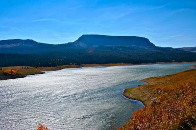
Sunlight glinting off the lake

Wispy clouds and suspended raptor

The trailhead for Devil's Causeway is at the far end of Stillwater Reservoir west of Yampa. The road dead ends into a large parking area near the dam. The trail follows the shoreline of the reservoir for 0.8 miles and minimal elevation gain before cutting inland to another trailhead. Take the right fork for the East Fork Trail. This is the trail to the Causeway.

Trail junction with the East Fork Trail

The Chinese Wall comes into view

After the fork, the trail wanders through a Lodgepole/Fir forest and at 1.08 miles comes to the Wilderness Boundary and the first good view of the Chinese Wall. At 1.63 miles the trail breaks out of the trees and traverses a long slope covered in talus. To the left is Little Causeway Lake and in front is a bare basin with an obvious saddle. The route looks more intimidating than it is. It does not take very long to get to the base of the saddle. Be sure to turn around every once in a while to admire the view behind you.

Heading into the trees

The first view of the saddle

From the base of the saddle, there are a series of lazy switchbacks. We met two hikers coming down who had just returned from the Causeway. One indicated that he had gotten about 1/3 of the way across but turned around because of the shifting winds. The other gentlemen indicated that he had been up to the Causeway at least 6 times and each time he had only been able to get within 50 yards of it. This served to freak me out and I started getting the ebbie jebbies on the uppermost switchback that narrowed unnervingly. Fortunately, the saddle is a broad plateau and not a narrow ridge. While the wind was blowing like Zeus, I at least could catch my psychological breath.

The trail heads across the talus field to the right.

Little Causeway Lake from the talus slope

The ascent up to the top of the Chinese Wall looks more intimidating than it is. While there is a drop off on either side, the trail travels up the middle with limited views on either side. The biggest challenge is that the route is very steep and very loose. At one point I could not stand up at all and was leaning into the slope with my feet sliding backwards in the dust. There was nothing for my hands to grab onto except a few loose rocks and more dust. Be sure to take a break half way up to admire the view.

Heading across flats toward the saddle


My destination from the area below the saddle

At the top of the ridge is an area filled with willows and rocks. To the right was a nice flat area where I dumped by pack. No way was I taking it to the Causeway. The wind had died down a bit which was nice. I started walking towards the Causeway, camera in hand. It is a short 2 minute walk. As soon as it came into view, I started cackling nervously and I confess a few unprintable explicatives passed my lips.

Getting closer to the saddle

Looking down on the switchbacks

As trail became more and more narrow and I continued on much to my personal amazement. I was on the cusp of the rocky portion of the Causeway when all of a sudden the vertigo hit as my peripheral vision picked up the drop offs on both sides. I landed with an ignominious thud in the dirt. I quickly wedged by butt into a small rock circle to give my mind the illusion of stability. Nuclear War or perhaps a slobbering carnivore might have gotten me moving again, but not much else. I turned around and my hiking partner had collapsed about 30 yards behind me. I coaxed her forward to my position. I have heard Devils Causeway described this way...walking, walking, walking, HIT THE DECK. I found this to be startlingly true.

On the saddle. Note the wind-filled jacket.

Looking up at the final pitch

From my vantage point I could look, after much Lamaze breathing, straight down the right side of the wall. Lost Lake valley loomed in the distance, and the wall curved photogenically around to the right. While I snapped pictures of the view, the dogs poked around on the rocks, increasing my vertigo with each bounding leap.

The view to the east from half way up the final pitch

On top of the Chinese Wall. The Devil's Causeway is just ahead. Would you go any further?

Finally, after sitting there for 10 minutes or so my mind said enough and I lumbered upwards and flung myself back down the trail. Reaction to this story has been mixed. Some of my friends have shuddered at the mere thought, others have laughed knowing that they crawled on their bellies across. Devil's Causeway is a highly personal experience.

The dogs frolic on the Devil's Causeway. This picture makes it seem a broad plateau. It feels much more narrow.

The view of the Chinese Wall from my butt-planted position.

Fall colors on the left side of the Wall

Since the views of Flat Tops is so spectacular, I found my pack and moved to a large plateau where I could lounge, eat, and reflect. As I said in my intro, if you don't like heights, ascending to the wall for lunch is still a viable option.

Lost Lake and the north side of the ridge

Flat Top Mountain from my lunch spot


This hike is featured in Colorado's Hundred Classic Hikes. I have yet to hike a trail in this book that was not spectacular. Buy from Amazon and I will receive a small commission.


North Rock Creek Snowshoe

Distance: 4 miles round trip Elevation: 9,180 ft to 9,780 ft Elevation Gain: 600 ft Dogs: Off leash until the wilderness boundary North...