Showing posts with label fishing. Show all posts

Saturday, August 18, 2012

Carolyn Holmberg Preserve at Rock Creek Farm (Stearns Lake)

Distance: 3.6 miles round trip
Elevation: 5,276 ft
Elevation Gain: Nominal
Date Hiked: 8 July 2012
Bathroom at Trailhead: Yes
Dogs: On leash (Boulder County Open Space)
Tags: #lake, #bcos, #stearnslake

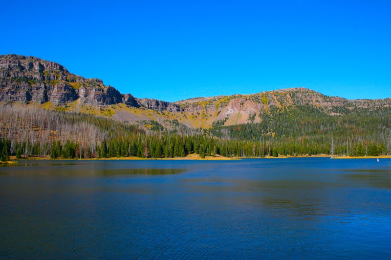
Looking at Stearns Lake in the Carolyn Holmberg Open Space
The Carolyn Holmburg Perserve at Rock Creek Farm is a small Boulder County Open Space located north of Broomfield on Highway 287.  It is popular with fishermen and locals taking strolls with their kids and dogs.  Located in the middle farm land, it is very pleasant in the spring and fall and is usually snow free in the winter.

Trailhead with parking and picnic enclosure
Starting out on the Mary Miller Trail
I chose a steamy day in July 2012 (can you say record heat anyone?) to try running the trails in the park so I grabbed my cell phone to track my pace and distance as well to take pictures on the fly. If the pictures in the post don't seem up to snuff, that is why.  In the humid air, my phone was like a wet bar of soap

Farmland stretches off to the right.  The lake is on the left behind the berm.
The route leaves the lake (out of frame to the left) and heads off to the east.
There are several named trails in the area, but the logical route is to leave the parking lot and head due west along the shore of Stearns Lake.  Technially, this is the Mary Miller Trail, but that name is not evident as you leave the parking area. As you head east, you may see Canada Goose, which frequent the Cottonwood-lined shoreline.

The road leading due east that intersects the trail.  The directional sign is on the post to the right.
Close up of the directional sign.  The arrows point down the road.  I am not sure this is how they want people to go.  If you avoid this turn you come to another trail sign further up the road.
On the far eastern side of the lake there is a large gate and dirt road that continues directly eastward.  Attached to the right-hand post of the gate is a trail sign with two arrows.  This sign was just loosely attached with some wire and was twisted in such a way that the arrows were pointing down the road.  This is NOT correct.  While you can take this road, it may be private so when you come to this junction, continue northward until you see a large trail sign pointing to the right.

If you keep going this is the sign that point to to the trail as it forks eastward.
Looking back towards the lake near several interpretive signs.  Farmland is on either side.
From this point of the route, the trail heads eastward along a slight ridge looking down on a working farm.  I chose to turn around when the dirt trail turned to pavement as it connected to a bike path heading under Highway 287.

My turn around point.  This is where the gravel path becomes paved and travels under Highway 287.  Note the farm buildings in the distance.
Back near the trailhead, this is the sign pointing to the Cradleboard Trail, which from this angle heads off to the right.
After running back around the lake, I took a left on the Cradleboard Trail, which heads due south before more curving westward.  The Cradleboard trail comes to a junction at a dirt road.  To return to the parking lot, turn right.

A typical segment of the Cradleboard Trail.  The Flatirons can be seen in the far distance.
The junction where the Cradleboard Trail continues southwest and a dirt road wraps around to the north to return to the parking lot.
One of things I love about Colorado is that "parks" are more often open space rather than green grass and manicured deciduous trees.  The Carolyn Holmberb Preserve is a perfect example.  While not large, it is perfect for a short run, afternoon stroll, or picnic at the shelter in the parking area.

The parking is ahead in the distance
Map of the trail system.  The dirt road is marked with a dotted line.


Sunday, December 12, 2010

Pella Crossing

Distance: 1.5 mile loop around Sunset Pond and Heron Lake
Elevation: 5,095 ft
Elevation Gain: None
Critters: Water fowl
Dogs: On leash (this is a Boulder County Open Space Park)

Looking west from the far end of Heron Lake in the Pella Crossing Open Space Park

Pella Crossing is a lovely open space park near Hygiene that is popular with runners, birders, and fishermen. In October, I took my parents there on an afternoon stroll. I took a picture every few feet and every one was a keeper.

Map of the Open Space Park. We took the route counter-clockwise. The inset in the upper right of the maps shows the lakes on the other side of N 75th St.

Faded Yellow Rabbitbrush (Chrysothamnus viscidiflorus) clings to the side of Sunset Pond

A panoramic view. I don't know what this area is like in the spring, but in the fall, it is sublime.

The entire route is as wide, flat, and appealing as this shot.

The area consists of several adjacent lakes with a well-groomed, handicapped-accessible trail that winds around them. Open fields and Cottonwood trees line the route and skydivers were seen jumping from a plane overhead to land in a nearby airport.

Sun glints through a very large Narrowleaf Cottonwood (Populus angustifolia )

A seed pod from the Common Milkweed (Asclepias syriaca) cracks open in the warmth of the Indian Summer sun.

The fibers of the Milkweed plant were used in WWII to stuff life preservers and are now used in many other products since it is better than down in insulating properties.

Fishing for Large Mouth Bass is encouraged and belly boats are common. There are actually 5 lakes, 3 on the east side of N. 75th Street and 2 on the west side. We only walked around the lakes on the east side (Sunset Pond and Heron Lake), but a longer route is possible by crossing over and walking the other side.

The back side of Sunset Pond

Long's Peak (14,259 ft) is barely visible through the clouds that hang over the mountains.

Fisherman in a belly boat drifts serenely on the west end of Sunset Pond. The lazy movement of his fins did not disturb the glass-like surface of the water.

Monday, November 29, 2010

Spague Lake Nature Loop

Distance: 0.9 mile loop
Elevation: 8,694 ft
Elevation Gain: None

Delightful Sprague Lake with Hallet Peak in the background

The trail around Sprague Lake in Rocky Mountain National Park near Estes Park is short, flat, and very scenic. I took my parents there on their recent Colorado vacation. We ate lunch on one of many picnic tables near the trailhead and then strolled the short route around the lake. The trail is well groomed, totally flat, and suitable for everyone. The views change constantly providing a great deal of variety in a short distance.

The bridge from the picnic area to the lake

Trout were abundant in the outlet stream

Sprague Lake has in interesting history as well. It is actually man made and was constructed by Abner Sprague who owned a lodge nearby long before the area became a National Park. You would never be able to tell this by the "naturalness" of the setting.

The loop going left (the route we took)

The loop going right

The lake is well stocked with fish and you can actually see them in the outlet stream and even larger specimens along the lake shore.

Looking southwest in early October on my first visit. Note the fisherman standing well out in the water

The sudden and welcome view of the Continental Divide. No wonder Abner built the lake here.

The first time I visited this lake, I only walked part way around, trying to judge if it would be suitable for the parental units. I did not notice at that time the stunning views of the Continental Divide including Hallett (12,713 ft), Taylor (13,153 ft), and Otis (12,486 ft) peaks that greet the visitor half way around. I wish ole Abner had sold his land to me so I could have that view for my living room window.

Small viewing platform

Across from the view platform the lake shore is bordered by reeds.

If you visit Rocky Mountain National Park, don't exclude Sprague Lake from your list, particularly if you are staying at the nearby Glacier Gorge Campground. There is a short 0.8 mile trail between the campground and the lake.

A final view of the lake and the reflections of the trees in the still waters

Friday, October 29, 2010

Skinny Fish Lake Hike

Distance: 5 miles round trip
Elevation: 9,269 ft - 10,269 ft
Elevation Gain: 1,000 ft (net), 1,432 ft (cumulative)
Dogs: Voice and Sight Control (Flat Tops Wilderness)

The right-hand side of Skinny Fish Lake. There was one tent on the far end but not another soul around.

Skinny Fish Lake is a short (but not nearly as short as the Forest Service advertises) trip to a scenic lake surrounded by the infamous Chinese Wall, a unique geologic formation in the Flat Tops Wilderness. We chose this trail because we thought it was really short (advertised distance is 3 miles round trip) and we just wanted to stretch our legs after driving the Flat Tops Scenic Byway.

Looking south from the parking area

Looking up the drainage from the parking area

The trailhead for this hike is located on Trappers Lake Road in the Flat Tops Wilderness. It is clearly marked on the map and the parking area is quite obvious.

The initial pitch. The sky is still blue, but storm clouds are brewing to our left.

The lower portion of the trail winds through Aspens. The forest was damp and earthy, just what I want in the fall.

The trail begins by heading up a steep hill filled with Aspens. On this rainy fall day, they were in full color. At 0.9 miles is the junction with the Lost Lake Trail. Lost Lake is on the other side of the wall and this trail goes around it reach the lake. After crossing a small stream (nice bridge), the trail enters a broad, grassy meadow. Here the eastern portion of the wall comes quickly into view. Its stair-stepped features are both interesting and intimidating. This is one large hunk of rock. At 2.11 miles is the intersection between the Skinny Fish and McGinnis Lakes.

Even the undergrowth was putting on a show

Looking back down the drainage. The sky is getting more threatening

Since our time was short, we chose to head towards Skinny Fish Lake since we guessed that it would not be totally in the trees. This turned out to be a good choice. The lake is surrounded on 2 sides by the Chinese Wall. It is broad and welcoming. I can not report what McGinnis Lake looks like, but if you go all the way to Skinny Fish, you might as well pop over to McGinnis.

Our first glimpse of the effects of the Big Fish Fire

A scenic creek. It is raining by now.

A good portion of the trail traverses the 2002 Big Fish Fire area. This lighting sparked fire burned over 17K acres of prime wilderness. The skeletal remains of Aspen and Lodgepole stand as a stark reminder to the transience of Nature. Nothing is permanent.

Fall willows and dead trees make a startling contrast

The Chinese Wall comes into view. This picture does nothing to capture the scale. The wall dominates the valley and seems to loom over everything.

This trail held another surprise for me. In the Flat Tops Wilderness, dogs do not have to be on leash if they are under voice control. I guess it is only the crowded Front Range Wilderness Areas where the leash law is mandatory.

Looking back towards the trailhead from the middle of the meadow.

Looking straight across Skinny Fish Lake to the Chinese Wall beyond. Blue skies return. Such is Colorado and why we always carry rain gear.

On this trip, this was the only hike we did in the Trappers Lake area. There may be others that are more scenic, but for us, this trail hit the spot. It got our legs moving and we got close to the Chinese Wall, which was another objective. Little did we know that the following day we would climb to the top of the wall on our harrowing trip to the Devil's Causeway.

Sunday, September 26, 2010

Officers Gulch

Distance: 1.5 miles (estimate) around the lake
Elevation: 9,452 ft
Critters: Dragonflies and fish

A view of Officers Gulch looking towards Copper Mountain

Officers Gulch is a small Colorado lake right off of I-70 near the western exit for Frisco in Summit County. I decided to check it out one lazy Sunday. It turned out to be quite pleasant. There is a short trail around the lake and numerous social trails for fisherfolk who wish to cast a line.

This gentleman was fishing on his own private island that he kayaked out to


The view near the parking lot

A short bridge leads to the eastern side of the lake

The lake itself was alive with pond skimmers and dragonflies and numerous tree species dotted the area.

Some plants in the area


This strange looking "cone" on a Colorado Blue Spruce is a Cooley Spruce Gall (abnormal tissue outgrowth caused by insects or other invaders) that has swollen the stem. Cooley Spruce Galls are common and are caused by an aphid-like insect. The spines on it are "mutated" spruce needles. Thanks to reader for identifying this for me.

Lodgepole Pine

While the noise from I-70 is never far away, the area does boast ample parking.

More views around the lake

Looking southwest

Looking north

Looking northeast from the western end

North Rock Creek Snowshoe

Distance: 4 miles round trip Elevation: 9,180 ft to 9,780 ft Elevation Gain: 600 ft Dogs: Off leash until the wilderness boundary North...