 Fall color on Highway 26
Fall Color OH MY GOD!!!!!
To someone who has never seen the brilliant reds of a hardwood fall, our marathon drive to Copper Harbor and back was one long continuous scream. Toss in a mountain pass, Bald Eagles frolicking in the trees, and a brandy infused fruitcakes from the Jampot, and you have the makings for a quintessential fall day.
 Elaine and Lynn search for the perfect leaf. These were plastered on the inside windows of the car.
Refer to my
map of the trip for a blow up of the roads on the Keweenaw Peninsula. We started out in Silver City, drove through Ontonagon, up Highway 26 to Houghton, took Highway 203 to Calmut, stopped in Coppertown, went through Eagle River and Eagle Harbor, took the Brockway Mountain Drive, ate lunch in Copper Harbor, and finally high tailed it late in the day back down Highway 41 to Shelter Bay. Phew! Now for the details.

(Left: Red Maples along Highway 26)
Much of the fall color on the route was in two locations, farther south on Highway 26 and farther north after leaving Copper Harbor. The day was very rainy so the colors in my photos muted believe it or not. We stopped along the side of the road so that I could take a picture of the highway and noticed a dirt road leading off into the trees.
Supercalafragalisticexpaladocious! I can still close my eyes and still see these brilliant colors. They are emblazoned on my retinas. You could have left me there and I would still be taking pictures. My only regret is that I did not drag my tripod along. The sky was very dark, and even with a high ISO, my photos are less than perfect. Still, they hint at what we saw.

(Right: The entrance to the Coppertown Museum).
The route took us through Houghton, which is a large town with many hotels and a super Wal-Mart. After the sparse infrastructure of Silver City, it was almost intrusive. It was not long before we were out of town, however, and crossing over to Hancock and up the coast.

(Left: Inside the Coppertown Museum).
We stopped at Coppertown, which is a National Historic Park in the making. There were plenty of old brick buildings and a new museum that contained tons of relics from the Copper mining era. With our National Parks Pass, it only cost us $3 to get in.
From Coppertown, we headed up towards Eagle Harbor. On the west side of the loop, there are glimpses of small towns, lighthouses, and old homes. The water is not always visible but it is pleasant. There was a cold rain falling that made us hesitant to get out of the car and I felt continual pressure to keep moving since we were staying near Munising that night and Munising was a long ways away.
 Coppertown's old buildings
We did allow ourselves a short stop at the
Jampot, a store run by the Society of Saint John, a Byzantine Monastery. Inside were delectable preserves made from local berries, muffins, and fruitcakes infused with brandy and other liquors. We purchased wild strawberry, thimbleberry, and bilberry. So far only the bilberry has been tasted. Lynn reports that it is scrumptious. We also grabbed a walnut-ginger fruitcake whose cheesecloth wrapping reeked of liquor. I loved it, and altruistically brought some back to the folks at work who also raved about it. The Jampot does mail order by the way, so you don’t need to travel to the UP to experience these unique treats.
 Sign at the summit of Brockway Mountain Drive
Just before the turn off for the Brockway Mountain Drive is Lake Bailey. We watched Wood Ducks zip about in the rain with our binoculars. I really wish I we could have gotten out of the car at that point. I have never seen a Wood Duck up close.
 View from the summit of Brockway Mountain Drive. It was raining enough that it was hard to keep water off the camera lens.
Some folks at the Coppertown Museum told us about Brockway Mountain Drive. This route cuts off ten miles from the Highway 26 loop and is well worth it. It ascends to a [snort] dizzying height of 1,328 ft above sea level (726 ft above Lake Superior). Fog gripped much of the low lands, obscuring the really great views, but it was dramatic nonetheless. This route also enabled us to view Copper Harbor from above.
 Copper Harbor viewed from Brockway Mountain Drive
In Copper Harbor we ate lunch at the
Harbor Haus, a quasi-German/Midwest restaurant. I say quasi because even though some of the staff was dressed in Dirndls and there were beer steins along the walls, the food was more Midwestern than German. Here we had our best Whitefish meal of the trip. Whitefish (Coregonus clupeaformis) is ubiquitous in the UP. They school and feed near the lake bottom and are harvested by the millions. While still plentiful, they are being over fished just like every other “ocean going” creature. We certainly condoned this by overfeeding on Whitefish on this trip. I wish we could have taken the Harbor Haus along with us for the rest of the trip where the food was less inspiring.
 Copper nugget outside the Harbor Haus restaurant
At this point we were tempted to cancel our cabin in near Munising and stay in Copper Harbor. It was 4pm already and we had no idea how long it would take us to get to Munising. We asked to see some rooms in the numerous roadside motels in Copper Harbor. Most were dark, and filled with thrift store furniture. They at least had views of the harbor. Not knowing what awaited us in Shelter Bay, we decided to head out. This turned out to be an excellent choice because our cabin on Shelter Bay was not only beautiful and cozy, but was situated within yards of the lake.
 View of the Harbor Haus dock. There are flags of Germany, Finland, Sweden, the United States, and Michigan.
Highway 41 forms the eastern side of the loop around the northern Keneenaw Peninsula. Here we found the famed tunnel of trees. This short stretch of road did not just show off its fall color, it engulfed its visitors so that there was no such thing as sky, just brilliant reds and the road. We were one with autumn. On a bike, this short stretch of road would have led to a religious conversion. It certainly produced many rapturous sighs. If such a road existed in Colorado, it would have been so clogged with cars so that no one would be able to move. We saw only 5 or 6 cars, however, so our bug-eyed epileptic fits of amazement went gratefully unnoticed by fellow leaf peepers.
 The tunnel of trees on Highway 41 leaving Copper Harbor
The drive from this point on was a marathon push that ended in a dark and dreary slog through the pouring rain. The shore of Lake Superior is pitch black at night and we needed guidance to find our cabin. At one point we were staring directly at the road on which it was located and could not see it. When we awoke the next day, however, the cloud filtered sunlight revealed a marvelous treat. That will be the subject of my next post.


 Looking west from the far end of Heron Lake in the Pella Crossing Open Space Park
 Map of the Open Space Park. We took the route counter-clockwise. The inset in the upper right of the maps shows the lakes on the other side of N 75th St.
 Faded Yellow Rabbitbrush (Chrysothamnus viscidiflorus) clings to the side of Sunset Pond
 A panoramic view. I don't know what this area is like in the spring, but in the fall, it is sublime.
 The entire route is as wide, flat, and appealing as this shot.
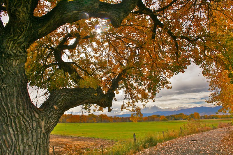 Sun glints through a very large Narrowleaf Cottonwood (Populus angustifolia )
 A seed pod from the Common Milkweed (Asclepias syriaca) cracks open in the warmth of the Indian Summer sun.
 The fibers of the Milkweed plant were used in WWII to stuff life preservers and are now used in many other products since it is better than down in insulating properties.
 The back side of Sunset Pond
 Long's Peak (14,259 ft) is barely visible through the clouds that hang over the mountains.
 Fisherman in a belly boat drifts serenely on the west end of Sunset Pond. The lazy movement of his fins did not disturb the glass-like surface of the water.
  The entrance to the Stillwater Area with Flat Top Mountain (12,354 ft) in the distance
 A slope covered with past peak Aspens. This area seems more wind blown than the northern area that the Flat Tops Scenic Byway goes through.
 The Chinese Wall and one of the reservoirs
 Looking down on the Bear River as it winds lazily through the valley. There were several fisherman standing in the call waters.
 Looking back down the valley

 (Left: Red Maples along Highway 26)
 (Right: The entrance to the Coppertown Museum).
 (Left: Inside the Coppertown Museum).


 I grew up in California and my mother and I would take an annual pilgrimage to the Sierra Nevada Mountains in search of any color. It was rare indeed. A single tree would have us all a tingle. A small grove would elicit a near epileptic seizure. We would return from these expeditions ready to cook squash on the backyard BBQ, convinced we were awash in Fall’s mantel. My father, who grew up near Boston, viewed these events with typical East Coast noblesse oblige. He would look at us over the brim of his book with a condescending “foolish mortals” gaze. We were indeed so naïve. While it is true that the East Coast has those vibrant reds and cascading hillsides, Colorado has snow-capped peaks reflected in still lakes dripping with reflected gold. Having to burn a few calories to see it is an added value in my mind.
  The Colorado trail continues south with sweeping views of South Park and the mountains beyond. We turned around after about two hours because it was beginning to rain. Upon return to the trailhead, we were greeted by 10,000 other peepers crowding into the parking lots and blocking the road. The take home point for this post is get and early start.


