Trappers Lake is at the heart of the Flat Tops Wilderness. Once a gem of phenomenal beauty, it is now scared by the skeletal remains of the 2002 Big Fish Fire. When I chose this destination, I had no idea of this fire. Most guidebooks of the area were written before this date and don't include it in their descriptions.
The lake, which is a true wilderness lake, must be walked into although the walks are as short as 1/4 mile. I took pictures at two common areas. The first is from the Outlet Trail on the north side of the lake. As you drive in, the road forks just past the local lodge. The left fork dead ends at a berm. The outlet trail climbs up this berm and then circumnavigates the lake. There are many pretty spots within a half mile for those not interested in walking far. The second spot was past the campgrounds on the right fork. We followed the road to the Wall Lake Trailhead, turned left and parked in the large parking area. There is a short trail out to an overlook.
Trapper's Lake is also known as the beginning of the Wilderness movement. In 1920, the Forest Service hired Arthur Carhart to survey the area for potential development. Carhart was so moved by the beauty of the area that the lake was protected from all development. This concept was quite new at the time and served as the seed for the establishment of the Wilderness Act.
There is a lodge near the lake that has cabins and a small restaurant. The lake is 1.5 miles by 0.5 miles wide and is 180 ft deep. There are numerous trails in and around the area. We hiked Skinny Fish Lake, which is a few miles before the lake.
Showing posts with label Trappers Lake. Show all posts
Showing posts with label Trappers Lake. Show all posts
Tuesday, November 2, 2010
Monday, October 25, 2010
Scenic Drive: Flat Tops Scenic Byway to Trappers Lake
Hikes in the area: Skinny Fish Lakes, Trapper's Lake, Devil's Causeway
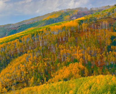
 A zoomed view from Dunckley Pass looking deep into the valley
The Flat Tops Scenic Byway will make you GASP in the fall. It is by far the most scenic drive in Colorado I have driven thus far. While other roads let you glimpse Aspens, this road lets you wallow up to your neck in Aspens. After a couple of hours driving, you will run out of explicatives and just start grunting, moaning, and hyperventilating. And that is just the start. This was an all day drive. My destination was Trappers Lake. I had so many photos it was hard to decide on which ones to post. Unfortunately, I was shooting with the sun high in the sky, which is not the best.
This is the route I took...
- From Yampa go north on County Road 17, which becomes County Road 19.
- Turn left onto County Road/State Highway 132, which becomes County Road 8
- From County Road 8 turn south onto County Road 8a/Trappers Lake Road/Colorado Hwy 155


Subscribe to:
Comments (Atom)
North Rock Creek Snowshoe
Distance: 4 miles round trip Elevation: 9,180 ft to 9,780 ft Elevation Gain: 600 ft Dogs: Off leash until the wilderness boundary North...

-
Mayflower Gulch near the Copper Mountain Ski Resort is by far one of the best snowshoes in Colorado and it is within an easy drive of five m...
-
Distance: 6.4 miles round trip Elevation: 9,350 ft - 9,910 ft Elevation Gain: 851 ft (cumulative) Bathroom at the Trailhead: Port-o-lets ...


