Showing posts with label Quandary Peak. Show all posts

Saturday, December 12, 2015

McCullough Gulch Snowshoe

Distance: 3 miles round trip
Elevation: 10,300 to 10,995 ft
Elevation Gain: 695 ft
Bathroom at Trailhead: No
Dogs: Off leash
Date Updated: 12/13/15
Tags: #Breckenridge, #snowshoe

View of Red Mountain (13,229 ft) at the terminus of the McCullough Gulch Snowshoe 
McCullough Gulch near Breckenridge CO is a great place for a short but scenic snowshoe. The imposing side of Quandary Peak is your constant companion on the left heading up the gulch and Red Mountain (13.229 ft) dominates the views on the way out.

Map showing the route and parking area off of highway 9 out of Breckenridge.
The winter trail for snowshoe is a large plowed parking lot on Hwy 9 heading to Hoosier Pass from Breckenridge. It is located around a mile before the turn off to Co Road 850, the traditional turn for both Quandary Peak and Quandary Falls. The lot is unmarked, but should be evident.

Heading up the trail
Quandary Peak as seen from the right side of McCullough Gulch
The trail starts out in a Ponderosa forest but quickly segways into open meadows with occasional stream sightings. Quandary Peak is always present, tendrils of snow whisking from its summit. Turn around from time to time, however, because as the trail gains altitude, the views to the east of Red Mountain (13,229 ft) become increasingly expansive. At the apex of the route, this view is nothing less than stunning.

Old cabin at 0.84 miles
The view begins to expand to the east
There are several milestones on this trail. At 0.8 miles is an old cabin and at 1.5 miles is the intersection with the Wheeler National Recreation Trail. Another tenth of a mile beyond this is the intersection with a spur road that heads off to the left across the gulch and intersects with Co Road 851 heading to Quandary Falls (see map). At this point you can head across the gulch if you like or continue straight for another 0.4 miles up a broad shelf that dead ends into a rock wall. We chose the latter. If the given the choice between going up and going down, Coloradans invariably want the up.

The trail ends just ahead
Aspens on the hill
The last quarter mile is steep (150 ft up from the intersection), but the views will have you sighing with contentment, or perhaps sucking wind,  depending upon how fast you bolted up that last bit. Pull out your linen tablecloth, the foie gras, and feast! This is the kind of view you see in travel brochures.

Looking back on the final pitch
While McCullough won’t get you trained to climb Quandary Peak, seeing folks on the peak, even in winter will motivate you. If you are staying in Breckenridge and want a short outing with continual payoffs, some solitude, and the sense of really being in the back country, then this trail may be just the ticket. Unlike Baker’s Tank on Boreas Pass Road, you won’t find the hordes here. Perhaps the snow is too deep, perhaps the altitude gain too intense, or perhaps it is just unknown.

Final view to the east

Wednesday, July 31, 2013

Black Powder Pass

Distance: 3.4 miles round trip
Elevation: 11,482 ft - 12,159 ft
Elevation Gain: 677 ft
Bathroom at Trailhead: Yes, in one of the out building for the Section House
Date Hiked: 26 July 2013
Dogs: Off leash
Tags: #hiking, #coloradooutdoors, #mountainpass, #gearguide


Looking east from Black Powder Pass near Breckenridge CO
The view looking east from Black Powder Pass
Black Powder Pass off of Boreas Pass near Breckenridge Colorado is a stunning destination that will take the hiker above treeline, along a flower-lined ditch and up to a verdant meadow filled with willows, flowers, and slap-your-mama views. Even better, this trail is short and therefore accessible to those who don't do Ironman Triathlons every other week.

Section House is a ski hut in the winter. That is Bald Mountain in the background.
The start of the trail is just a small National Forest Service sign
You get to the trailhead from Boreas Pass. This is the top of Boreas Pass Road, which starts on the south end of Highway 9 just as it leaves Breckenridge. It is 9.2 miles from the turn off on Highway 9 to Boreas Pass and most of the route is on a graded dirt road passable with a 2WD low clearance vehicle.

Starting out along the ditch
This one talus field is the only tricky obstacle on the trail.
Once at the pass, the trail begins at a numbered Forest Service trail sign just before the Section House, a 1900's building now used as a hut in the winter. The first 0.7 miles of the trail is along a Boreas Ditch 2 and its occasional water control gates and pipes. Wildflowers galore line the banks and the trail bisects and travels on both sides of the ditch. Don't worry both lead to the same destination.

This Hoary Comma (Polygonia racilis) landed on a Chimming Bell on the Black Powder Pass Trail Colorado
A Hoary Comma (Polygonia gracilis) butterfly landed briefly on this Chiming Bell just as I passed by.
Breaking out of treeline. The pass is visible in the distance.
At the end of the ditch, the trail bisects again with the right hand route going steeply up hill along a highly eroded segment. The left hand route, which we took on the way back, travels through willows and over roots. Either side will take you above treeline.

View of Quandary Peak and the Tenmile Range
Looking up at Mt. Baldy
Once out of the trees, the ridge to Bald Mountain on the left comes into view and views of the Tenmile Range dominate the west. The route gets steep at this point and heads steadily upwards through open tundra to the left of the creek that feeds Boreas Ditch 2. King's Crown, Queen's Crown, Harebell, Parry Primrose, Chiming Bells, Columbine, Elephant Head, Indian Paintbrush, Bistwort, Monkshead, and Purple Larkspur were just some of the flowers we saw along the way.

Standing on the pass looking south to Boreas Mountain
Wildflowers growing on the backside of the pass
Once at the pass, the trail itself goes over to a view spot looking down on South Park, Georgia Pass , and the route to French Pass on the tall ridge directly ahead. The rugged rocks of Boreas Mountain form a wall to the south. If you are going to climb Boreas Mountain, however, don't start from Black Powder Pass, but jump to the ridge directly from behind Section House.

Wildflowers encroaching on the trail
While short, this trail is still at altitude and after being gone from Summit County for several weeks, I found myself sucking wind as I approached 12,000 ft. Still, if you take your time, even folks with moderate levels of fitness should be able to make the pass. The view down the backside is well worth the effort. If you are a fit local, there is now excuse not to pop up to the left ridge for an ascent of Bald Mountain.

Thursday, August 14, 2008

Quandary Peak

Distance: 6.75 miles round trip
Elevation: 10,850-14,265 ft
Elevation Gain: 3,450 ft
Dogs: Off leash
Bathroom at Trailhead: No
Date Hiked: 12 August 2008
Tags: #14er, #peak, #mountainpeak, #Breckenridge

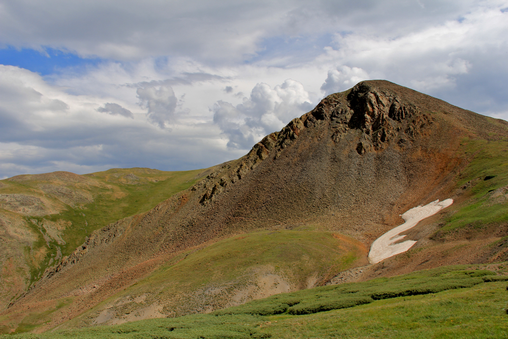
Quandary Peak (14,265 ft) viewed from the East Ridge
Quandary Peak near Breckenridge, CO is technically one of the easier 14ers. There is no large talus dome at the top to navigate and minimal exposure. There are also large rock steps placed frequently along the route so that at times it may feel like Stairmaster instead of a mountain. There is, however, a lot of loose skree that will make coming down a chore. Quandary Peak is also known for its numerous false summits.

The lower part of the trail is in the trees.
The elevation gain on Quandary is nothing to laugh at, but given a nice day without pressure from the weather, anyone who has either exercised regularly or who is very determined can achieve the summit.

Quandary Peak look like a giant snowboard ramp. The route stays to the sides of this ramp or ridge rather than ascend directly up the middle of it. Because of this, the views are spectacular the entire way.

Northstar Mountain viewed from the left side of Quandary's ridge
The trail to the summit is low enough that it begins in the trees. It takes you to the right, northern side of the ridge (McCullough Gulch), but then quickly winds back towards the southern side (Monti Cristo Gulch) where it will stay for the rest of the journey.

Monte Cristo Gulch and Blue Lakes
Around 12,000 ft, Blue Lakes deep in Monte Cristo Gulch come into view. This gulch is bordered to the south by a jagged ridge line that joins North Star Mountain to the east and Wheeler Mountain to the west. The dam at the end of the Gulch is the starting point for the West Ridge route up Quandary. This route is much more exposed and should only be attempted by more experienced climbers. At the time of this posting, renowned chef from Missouri died on this route another climber nearly died after a horrible tumble down the Monte Cristo couloir.

Summit viewed from the left
Heading up to the ridge at 13,150 ft
Quandary Peak is unique in that you can see the summit and much of the route from a road that many people travel getting to and from Breckenridge. The sharp rise in the "ramp" is clearly visible and looks enormous.  From its base the summit is only one mile and 1,100 ft of elevation gain away. The trail in this area is still mostly skree but is occasionally dirt. It is here that the false summits begin.

On the East Ridge, a little farther up
On the narrow portion of the ridge
Each succeeding pile of scree blocks the upper portions of the ridge and gives the illusion that it will be the last. Alas, you will be able to see the last pile and the summit just off to the left so until you do, don’t be fooled.

First large scree pile on the upper 1,000 ft
The last false summit
There is no large boulder field at the top of Quandary Peak. The top can be strolled across with ease. The views to the west are by far the most dramatic. Mount of the Holy Cross and Notch Top Mountain can be clearly seen to the west. Closer in, just across the West Ridge is the Fletcher Mountain and the backside of Mayflower Gulch. To the north is the cone-shaped Crystal Peak. To the south is Mt. Democrat, Mt. Lincoln, and Mt. Bross, and can even see some of the trails that connect these three.

The summit is in sight.
The journey down from the summit can be an exercise in drudgery. Loose rock requires more concentration than you would image. A joyous strain may just fill your heart upon reaching terra firma.

View from the summit looking northwest towards Crystal Peak
View from the summit looking at a hiker coming up the West Ridge
Back down, looking at the green hills of Summit County
Hiking to the summit of Quandary Peak will give you a fantastic sense of accomplishment and a great calf workout. It is close to Denver however, so expect crowds.

The trailhead to Quandary Peak is accessible via a normal passenger car. From Breckenridge, drive 8 miles south on CO Highway 9. Turn right (west) on the 850 (Blue Lakes) Road. Drive a few hundred yards and turn right on the 851 (McCullough Gulch) Road. Drive 0.1 mile to the signed trailhead and small parking area.

North Rock Creek Snowshoe

Distance: 4 miles round trip Elevation: 9,180 ft to 9,780 ft Elevation Gain: 600 ft Dogs: Off leash until the wilderness boundary North...