Showing posts with label Indian Paintbrush. Show all posts

Saturday, August 30, 2014

Arapaho Glacier Trail (Rainbow Lakes side)

Distance: 9 miles round trip
Elevation: 9,958 ft - 12,346 ft
Elevation Gain: 2,170 ft (cumulative)
Bathroom at Trailhead: Yes
Dogs: On leash (Indian Peaks Wilderness)
Date Hiked: 10 August 2014

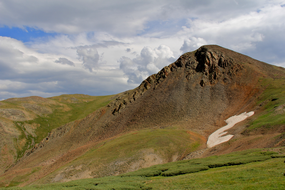
Looking into the City of Boulder Watershed from the Arapaho Glacier Trail
The Arapaho Glacier Trail in the Indian Peak Wilderness is a tundra superhighway that stretches from the 4th of July Trailhead in the south to the Rainbow Lakes Trailhead in the north.  Since the one way distance is 7.8 miles just from the 4th of July mine (two miles up), most people hike from one end or the other and double back.

Parking area and bathroom
Trails are well marked. I measured the trail split at 0.3 miles.
On this trip, we started from the Rainbow Lakes side, which is less crowded and affords eye-popping views of the City of Boulder Watershed, a private area of peaks and lakes that are postcard perfect. Don't be tempted to head that way, however. Set one foot across the well-marked boundary and a screaming horde of guard Marmots will gnaw your feet off at the ankles and turn you over to winter's inevitable embrace.

The first two miles are in the trees on a pleasant trail. Some parts are rockier than others.
Indian Paintbrush
The road to Rainbow Lakes starts from Highway 72 just north of Nederland. Seven miles northward is a sign for the University of Colorado Mountain Research Station on the right. Turn left here onto Forest Service Road 298. It is 5 miles down a road dirt road to the large parking area. I would recommend a high-clearance 2WD at a minimum and a 4x4 if you have one. The road is pitted, eroded, and very rocky in places. It takes much longer to reach the trailhead than you would think.

Treeline at 2.5 miles. Mt. Albion is just visible.
Harebell
The first two and a half miles of the route are in the trees.  Ironically, I was pleased with the dryness of the area and the subtle scent of pine needles baking in the sun after slogging through wet and humid Heart Lake a few days prior. I say ironic because we got caught in one of the wettest storms I have been in in years. Hail, torrential rains, and enough water on the trail to totally saturate my "water proof" boots.  Normally, this segment is quite pleasant.

Tundra and watershed view
After two miles, the trail leaves the trees and heads steadily upwards across a bare tundra hillside. At the first switchback at 2.8 miles, the trail overlooks the City of Boulder Watershed. This area is clearly marked on the National Geographic Map as a no-go zone so it has always been terra incognita. At least looking down into it has removed some of the mystery.

The clouds should have been our first clue
Harebell was covering the tundra in great swaths
From this vantage, the trail winds around the hillside to the east before turning sharply west again. At 4.4 miles is a saddle. Our turn around point was a spot just off the trail where views of the southern Indian Peaks dominate. Unfortunately, on this trip we only stayed 10 minutes before a distant rumble had us packing up and heading down.

On the saddle
Ptarmigan showing off its superb camouflage. This mother had several chicks with it. I could hardly see any of them and just pointed my camera in the general direction of where I thought they were.
Half way to treeline, the sky began to spit hail from a storm that had built early in the day over the Watershed. Thunder began to vibrate the air and we quickened our step to get down as quickly as possible. Despite all the gear, we were quite wet by the time we reached the trees and then had the pleasure of walking two miles on a trail slick with pea-sized hail and streaming water. Ankle-deep puddles were forming on any flat segment and the dirt was eroding around rocks as the torrent rushed downwards. The temperature dropped to below 40 degrees and a heavy mist descended. Even though I had both a stocking cap and gloves with me, they did little to keep out the cold after becoming saturated from the rain and mist. Had anyone one of us had an accident that prevented us from generating heat through movement, we would have had a serious case of hypothermia on our hands. This is just one more example of how the wilderness can torment those who are unprepared. For the most part, we are fat and dumb primates oblivious to nature's killing power as we hide behind our heated walls and espresso machines.

Off the trail now at our lunch spot. We are looking south, deeper into the Indian Peaks Wilderness.
I really would like to return to this trail on a nicer day. While the clouds and mist added to the photographic appeal of the area, it was a warning to stay in bed. 2014 has been such a short season that many of us have pushed the limits to enjoy the high country before winter grips it again.

Wednesday, July 31, 2013

Black Powder Pass

Distance: 3.4 miles round trip
Elevation: 11,482 ft - 12,159 ft
Elevation Gain: 677 ft
Bathroom at Trailhead: Yes, in one of the out building for the Section House
Date Hiked: 26 July 2013
Dogs: Off leash
Tags: #hiking, #coloradooutdoors, #mountainpass, #gearguide


Looking east from Black Powder Pass near Breckenridge CO
The view looking east from Black Powder Pass
Black Powder Pass off of Boreas Pass near Breckenridge Colorado is a stunning destination that will take the hiker above treeline, along a flower-lined ditch and up to a verdant meadow filled with willows, flowers, and slap-your-mama views. Even better, this trail is short and therefore accessible to those who don't do Ironman Triathlons every other week.

Section House is a ski hut in the winter. That is Bald Mountain in the background.
The start of the trail is just a small National Forest Service sign
You get to the trailhead from Boreas Pass. This is the top of Boreas Pass Road, which starts on the south end of Highway 9 just as it leaves Breckenridge. It is 9.2 miles from the turn off on Highway 9 to Boreas Pass and most of the route is on a graded dirt road passable with a 2WD low clearance vehicle.

Starting out along the ditch
This one talus field is the only tricky obstacle on the trail.
Once at the pass, the trail begins at a numbered Forest Service trail sign just before the Section House, a 1900's building now used as a hut in the winter. The first 0.7 miles of the trail is along a Boreas Ditch 2 and its occasional water control gates and pipes. Wildflowers galore line the banks and the trail bisects and travels on both sides of the ditch. Don't worry both lead to the same destination.

This Hoary Comma (Polygonia racilis) landed on a Chimming Bell on the Black Powder Pass Trail Colorado
A Hoary Comma (Polygonia gracilis) butterfly landed briefly on this Chiming Bell just as I passed by.
Breaking out of treeline. The pass is visible in the distance.
At the end of the ditch, the trail bisects again with the right hand route going steeply up hill along a highly eroded segment. The left hand route, which we took on the way back, travels through willows and over roots. Either side will take you above treeline.

View of Quandary Peak and the Tenmile Range
Looking up at Mt. Baldy
Once out of the trees, the ridge to Bald Mountain on the left comes into view and views of the Tenmile Range dominate the west. The route gets steep at this point and heads steadily upwards through open tundra to the left of the creek that feeds Boreas Ditch 2. King's Crown, Queen's Crown, Harebell, Parry Primrose, Chiming Bells, Columbine, Elephant Head, Indian Paintbrush, Bistwort, Monkshead, and Purple Larkspur were just some of the flowers we saw along the way.

Standing on the pass looking south to Boreas Mountain
Wildflowers growing on the backside of the pass
Once at the pass, the trail itself goes over to a view spot looking down on South Park, Georgia Pass , and the route to French Pass on the tall ridge directly ahead. The rugged rocks of Boreas Mountain form a wall to the south. If you are going to climb Boreas Mountain, however, don't start from Black Powder Pass, but jump to the ridge directly from behind Section House.

Wildflowers encroaching on the trail
While short, this trail is still at altitude and after being gone from Summit County for several weeks, I found myself sucking wind as I approached 12,000 ft. Still, if you take your time, even folks with moderate levels of fitness should be able to make the pass. The view down the backside is well worth the effort. If you are a fit local, there is now excuse not to pop up to the left ridge for an ascent of Bald Mountain.

Thursday, July 3, 2008

Diamond Lake

Distance: 5.2 miles RT
Elevation: 10,100-10,940 ft
Elevation Gain: 840 ft


Diamond Lake in July looking south

Diamond Lake is a wildflower Mecca with hordes of shutter bugs circling round and around choice Columbine and Indian paintbrush much like Muslims orbit the Kaaba shrine. Depending upon when you go, you can find flowers lower down near the trailhead or up higher in the large meadow that borders the lake. Go too early e.g. May and June and you will end up trodding through large drifts of snow and soggy expanses of melt water. The lake itself can be shrouded in dark clouds at this time too, which does create its own photo opportunities. I suggest waiting until mid-July, however if you want to wallow in wildflowers.


The Colorado Columbine (Aquilegia ceorulea) grows in meadows, woodlands, rocks, scree from June to August. It is also Colorado's state flower.

Be emotionally prepared to feel the press of humanity if you join the Hajj on weekend. Not only must you get to the parking area very early, but also you will be bumped and prodded by the multitudes trodding by. The Fourth of July trailhead is also the starting point for Dorothy Lake and Arapahoe Glacier so for part of the route you will be joined by more serious hikers. Lake is stocked as well, so anglers join the procession to the lake, some carrying inflatable dinghies to float in.


Chiming Bells (Mertensia ciliata) blooms from June to August along streams and waterfalls.

The trail begins to climb right off the bat and the hiker will traverse small meadows and forested slopes. Flowers exist in both places so keep your eyes open for more rare finds. There are several water crossings that are not arduous and which attract their own flock of water loving flower species like the ubiquitous Chiming Bells, which grow in huge clumps anywhere there is water.


Indian Paintbrush (Castilleja miniata) can be found all over the state in meadows, sagebrush flats, and meadows. It blooms from May to September.

At 1.2 miles the trails splits. Take the left fork and continue until you reach a pleasant waterfall. At this point the trail bends back upon itself and heads back down the valley. I find this feature frustrating and don’t know why the trail does just head straight up to the lake with out looping back. This is a psychological impediment I know. It is hard for us driven Americans to ever think of going backwards. This back tracking is also the steeper portion of the trail. It is in a darker forest with fewer views. Early in the season this is also where the snow can linger.


Diamond Lake

At the top of this steep pitch is a broad meadow with logs strategically placed to protect the sensitive plants. The views return at this point but it is best to sally to the lake where there are plenty of places to sit and snap pictures. I particularly like the stunted conifers here, which are wind blown and artistic. Their flag shapes are testament to the winds that flow down the valley from the north. On more than one trip to the lake, I have been hailed on, so bring rain gear even if the weather is pleasant in the morning.


Diamond Lake in May. A lot colder and more snow

Like the participants in the Hajj, you will be spiritually renewed by your journey to Diamond Lake and if you can go on a weekday, then you will reach this renewal without paying the price without having to follow the butt of the person in front of you.

North Rock Creek Snowshoe

Distance: 4 miles round trip Elevation: 9,180 ft to 9,780 ft Elevation Gain: 600 ft Dogs: Off leash until the wilderness boundary North...