Showing posts with label Breckenridge. Show all posts

Saturday, September 8, 2012

Iowa Hill Mining District

Distance: 1.2 mile loop, not counting spurs to visit buildings
Elevation: 9,600 ft - 9,910 ft
Elevation Gain: 310 ft
Bathroom at Trailhead: No
Dogs: On leash
Date Hiked: 17 June 2012

The restored boarding house is the highlight of the Iowa Hill Trail
Iowa Hill is a historical mining exhibit just north of the ski resort of Breckenridge.  Its short trail winds up and around a Ponderosa covered hill filled with interpretive signs, old buildings, and mining relics.  While Colorado has no castles it certainly has mining ruins!

The fancy sign at the entrance to Iowa Hill. The verbiage says trailhead, but that is actually 100 yards further up a dirt frontage road that starts near this sign. 
The official trailhead
Early trail segment through young Aspens
Obvious signs lead the way through the exhibits
Sluice box for capturing gold
Gentle trail segment
Blacksmith shop with interesting tools wired to the wall
It took me a bit to find Iowa Hill because it is much further north of town than than I realized. It is actually past the Highway 9 bypass and roundabout. To get there from downtown Breckenridge, take either Main Street or the Highway 9 bypass and head towards Frisco. If you are on the bypass, turn left at Airport Road and continue north. If on Main, go into the roundabout and take the bypass for a quarter mile or so and then turn right on Airport Road. The entrance is on the left of Airport Road near the public works facility. Take the short frontage road near the fancy copper and wood sign to a small parking lot with a typical trailhead sign. A small arrow on the fancy sign points the way.

Old mine shaft now filled in
Crane with Bald Mountain in the distance
Hydraulic pipes use gravity to enhance the  water pressure 
Example of the cannon head
You can actually see where the water cut into the hillside in large swaths.
Mining car outside a closed tunnel
Iowa Hill is all about hydraulic mining.  This technique involved shooting water canons at the hillsides to erode and dissolve the dirt and run it through a series of sluice boxes where heavy metals like gold fall out.  It is engineering intensive and does not exactly leave a pretty picture behind.

Canon perched on a hillside in the distance
Bench overlooking the lower part of the trail
Backside of the boarding house
Weeds along the house highlighting the mud insulation between the logs
Close-up of the log construction
Iowa Hill educational and pleasant, although I did it on a day when it was way to hot, so plan accordingly if you are in Breck during another Colorado heat wave. If you like this sort of thing you can also check out the smaller Lomax Mine on the way to Peak 8 in Breckenridge.

Thursday, July 26, 2012

Lomax Mine

The entrance to the Lomax Mine historical area near Breckenridge
The Lomax Mine is a series of historic buildings near Breckenridge from a Gold placer hydraulic mine circa 1860.  Gold being a heavy metal tends to sink in water, so a placer mine ran water over gold bearing rocks and the gold would sink to the bottom of long sluices. A hydraulic mine is one that used large water canons to blast away the surrounding hillsides and run it through the sluices.

You can wander around the buildings or pay $10 for a tour that includes a history lesson. Iowa Hill south of town has a more extensive exhibit of this type of mining but also involves a hike. This exhibit is suitable for aged parents or small children.  

Old mining building
Plow
Indian Paintbrush near picnic tables at the back of the property
Looking back at the parking area 
Sluice Box
Hydraulic Cannon 
Close-up of the log construction
Broader view of the area
The Lomax Mine is located at 301 Ski Hill Road on the way to the Peak 9 ski lift area. From the Blue River Plaza in the center of Breckenridge, proceed north (toward Frisco) on Main Street one block to the stop light at Ski Hill Road/Lincoln Ave. Turn west (toward the mountains) onto Ski Hill Road. Proceed past the stoplight at Park Ave. and drive about 1/4 mile uphill to a Lomax Mine sign on the left and a driveway into the mine parking lot. Turn left into the parking lot.

Saturday, January 28, 2012

Pennsylvania Gulch Snowshoe

Distance: 5 miles round trip
Elevation: 10,400 ft - 11,105 ft
Elevation Gain: 705 ft
Date Hiked: 14 January 2012
Dogs: Off Leash
Bathroom at Trailhead: No
Tags: #snowshoe, #breckenridge, #coloradooutdoors

Pacific Peak (13,950 ft), Unamed Peak, Crystal Peak (13,852 ft) (barely visible), and Peak Ten (13,633 ft) dominate the view of Pennsylvania Gulch.
Pennsylvania Gulch is a lesser known but scenic snowshoe south of the Breckenridge Ski Resort in the hamlet of Blue River. It is known mostly to locals who use it extensively. Snowmobiles are allowed on the road but did not bother us at all.

You get to the trailhead by traveling 3.4 miles past the last Breckenridge traffic light and then turning left onto the Blue River Road. Proceed about 0.2 miles then turn bear right on Royal Drive. Bear right at the junction. Proceed about 0.2 miles then turn right on Regal Circle. Proceed about 0.1 miles. Turn right on Coronet Drive. Travel on Coronet Drive about 0.6 miles. The trailhead is by the information kiosk.

Map showing the location of the trailhead and the general route. 
The trailhead
Ruins of an old cabin less than 0.5 miles up the trail
The route follows Pennsylvania Creek up a eastward traveling gulch.  It starts out in the trees and heads steadily uphill for the first 0.5 miles. After that it levels out and comes to nice wide open expanse at 1.0 miles. This broad meadow filled with willows peaking out of fluffy snow mounds made the trip worth while. The views back down the valley were stunning as well with Pacific Peak and Peak 10 dominating the western horizon.

Typical early trail segment...in the trees
Breaking out into the meadow at 1.2 miles.  You can see the route on the left in the distance.
The only people we met were two cross-country skiers who turned around after the large meadow once the trail returned to the trees at 1.75 miles. We decided to continue and after another half mile in the trees we came to another open area and decided to continue to its end before turning around. This brought us to the spot at 2.5 miles where the trail crosses the creek. Along the way we crossed two other trails. Trail 6113A at 2.0 miles took off to the left while 113A at 2.35 miles crossed the creek and ascended into the trees on the right.

Whipped cream and willows grace Pennsylvania Creek
Looking west towards the Tenmile Range
There as been so little snow in Summit County this year, that I having been wearing microspikes everywhere instead of snowshoes.  This trail was no different, but since I had never done it before I wore snowshoes just in case.  They weren't necessary.  It is amazing how sore your hips feel after 3 hours in snowshoes.  The wider stance stretches muscles that aren't used very much.  I was glad when we turned around and headed back down.

The rocks on the area are high in iron and have a pleasing red tint.
Where the trail crosses Pennsylvania Creek...our turn around point
Pennsylvania Gulch is a pleasant outing that is suitable for beginners and skiers who like wide trails and a gentle slope (e.g. no head meet tree introductions).  I would take others there just to see the views of Tenmile Range.

Saturday, February 5, 2011

Sally Barber - True Romance Mine Snowshoe

Distance: 3 miles out and back to the Sally Barber Mine, 4.6 miles out and back to the True Romance Mine, 4 miles for the loop
Elevation: 10, 280 ft - 10, 685 ft (Sally Barber) - 11, 000 ft (True Romance)
Elevation Gain: 405 ft (Sally Barber), 720 ft (True Romance)

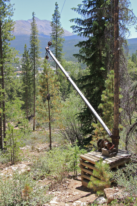
The ruins of the Sally Barber mine near Breckenridge CO are a popular snowshoe destination. 
The road to the Sally Barber Mine is a short, easy snowshoe to a interesting mining ruin near the town of Breckenridge CO. The route itself is uninspiring except for some nice meadow views at the beginning but for history buffs or cross country skiers, this is a great choice. If you are going only to Sally Barber, you might want to leave the snowshoes in the car and walk up on spikes since this popular route is usually well packed.

The parking lot
Trailhead sign
The route to Sally Barber starts in the same parking lot as French Gulch. 500 ft up the road, is a spur road with a gate. Follow this for 1.5 miles to the obvious ruin on the right hand side. Interpretive signs provide history of the mine itself and the local area.

The gate that indicates where the route to the Sally Barber Mine splits off from French Gulch
This route is popular with skiers because it is wide and gradual.
Across the road from Sally Barber is another gate and post indicating the route to the True Romance Mine. The route to the True Romance Mine goes straight up the hillside 300 ft through deep snow. There are no trail markers and lots of backcountry ski trails to avoid, so only do this if the route has been tracked or you have a GPS.

Snow mushroom along the route
Meadow view at the beginning of the route
Using a GPS, head upwards to the 11,000 ft contour which dead ends at a small bluff. The True Romance Mine is off to the left. From this point on the route is flat and follows what might be an old flume around the side of the hill. A few views of the northern Gore Range present themselves along the way.

Passing a serene winter creek
At 2.3 miles is a small plateau with a post with the works "True Romance" inscribed on it. There is no other ruin to mark the spot. At this point you have the choice of turning around and retracing your steps (4.6 miles total) or following what appears to be a road off to the right. Having never been to the area, we did not take this path and ended up on a less than pleasant bushwhack straight down the hillside.

The ruins of the Sally Barber Mine
Post at the start of the route to the True Romance Mine
View to the north from the 11,000 ft contour
We made this poor choice because someone had sprinkled the trees with pink reflective tape indicating a route down the mountain. We thought this was the route to the unnamed road we passed on the way up to Sally Barber. After trudging through trees, willows, and deep snow we finally intersected with the road that probably starts to the right of True Romance. I can not guarantee this, but the track on the GPS makes it a high probability so I feel comfortable sending you that way. 

True Romance Mine marker
So, for a short snowshoe just travel to the Sally Barber Mine. For a longer loop or out and back head up the hill for some increased cardiovascular activity. The True Romance Mine is not a destination spot, but your body and cholesterol levels will thank you for the extra effort.

North Rock Creek Snowshoe

Distance: 4 miles round trip Elevation: 9,180 ft to 9,780 ft Elevation Gain: 600 ft Dogs: Off leash until the wilderness boundary North...