Distance: 2 miles round trip
Elevation: 10,000 ft - 10, 200 ft
Elevation Gain: 200 ft
Dogs: Off Leash
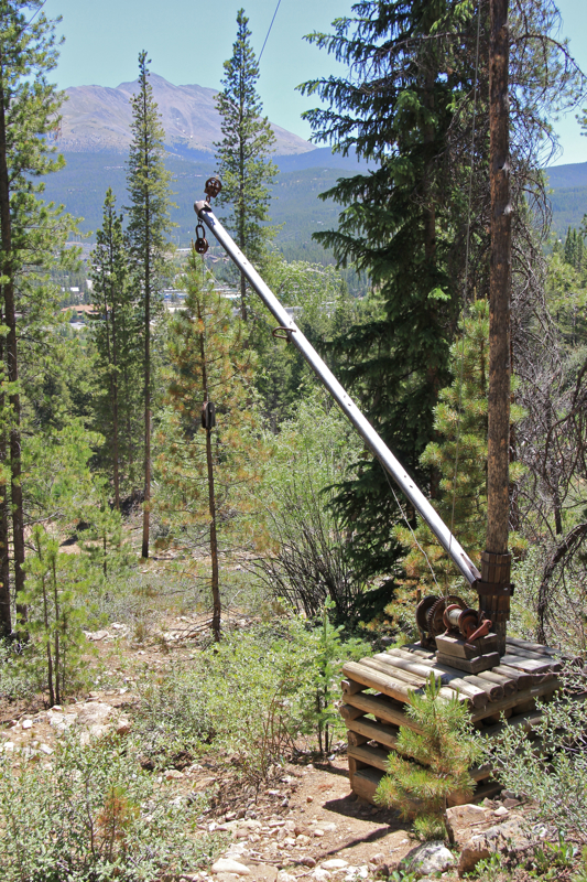
 Looking at the Therese Mine from the parking lot of the Vindicator Valley Loop. In the distance is a surprising view of the Sangre to Cristo Mountain Range. On a clear day it would be startling.
Want to take the express escalator into Colorado's past? You can do no better than the Vindicator Valley Loop near the towns of
Victor and Cripple Creek on the "back" side of Pikes Peak. This short, extremely well manicured trail, weaves by the ruins of over 500 gold mines. The structures that remain are extremely photogenic. If you love ghost towns you will love this short trip.
 The path is well manicured, suitable for children (if kept out of the ruins), and bordered by a wooden fence.
The trail through the mines is bordered by a wooden fence. Not only does this protect the ruins, it protects the hiker. This area looks solid, but underneath the ground it is Swiss cheese minus most of the cheese.
 One of the many powder magazines on the site. The dynamite and fuses were kept separate, just in case.
The gold near Victor Colorado is not the California 49'er variety where any yokel with more dreams than sense can plop by a stream and pan. This gold was formed in the fissures of ancient volcanoes. To get to the gold the ore must be pulled out of the ground, pulverized, heated to outrageous temperatures, and treated with chemicals. The massive structures that are required to get the ore is what the walker sees today.
 Looking northeast at Pikes Peak
This was a labor intensive effort. By 1900 over 50,000 workers lived in the area. Disputes were inevitable. Conditions were harsh underground, hours were long, and safety was not the most important concern. A strike that occurred in this area has become known as one of the battles in Colorado's Labor War (1903-1904). The prominent players included the Cripple Creek Mine Owners' Association (CCMOA) representing the operators, and the Western Federation of Miners (WFM), a labor union. What is interesting is the role of the State of Colorado, which deployed 1000 National Guard to keep order and invariably sided with the operators.
 A house surrounded by Fir trees at the northern end of the loop
Some sources say the Guard deployment was secretly financed by the CCMOA. Certainly, justification for the deployment was dubious, as least by today's standard, and many including the local Sheriff and Mayor tried to stop it. Many petitions were signed condemning the move.
 This is my favorite photo of the day. In the foreground is a ruin painted with the words "safety first", in the middle ground is a narrow wooden ruin, and in the far ground is the towering hill of the modern Cripple Creek and Victor Gold Mining Company. Trucks the size of small moons could occasionally be seen dumping dirt on the ridge line.
As a member of the Colorado National Guard I find this incident both telling and colorful. We ultimately work for the Governor of the State and so refusing to deploy would not have been an option for the Soldiers involved. Many of those same Soldiers would have come from the same working class background as the miners and may have felt very conflicted if not downright sympathetic to the men they were dealing with.
 There are lot of Aspens around Victor, which makes me think this would be a great fall color excursion.
In contrast to the average Soldier, the commanding general was a maverick with a fetish for imprisoning folks who spoke out against the "intervention". Victims included the County Commissioners and the Justice of the Peace. Habeas corpus was suspended and all sorts of legal shenanigans committed.
 How much longer these ruins will remain standing is an open question. They are already over 100 years old.
The miners lost their cause, however, when someone blew up a rail platform with 300 pounds of dynamite. They only thing they found of the non unionized men standing on it were bits and pieces. The press branded the union as terrorists and they lost public support. The union never recovered its influence in the region.
 At every vista is a plaque naming the mine and how much they had extracted. Most listed huge numbers like 38 Million, and this was in 1903 dollars. There were over 500 mines in the area.
Military intervention in labor disputes is controversial and certainly did not begin nor end in Victor Colorado. Even President Nixon deployed troops during a postal workers strike. My intent here is not to judge these or subsequent events, but present an interesting glimpse into Colorado's mining history.
 I loved this building. It dominates the 2nd third of the trail. Up close the red tin is striking.
So take a walk into the past on the Vindicator Valley Loop. Don't forget to swing through Victor for a taste of 1800's architecture. While you are there, stop by the Gold Camp Bakery on 3rd Street where Gertrude will serve you killer German desserts. I tried the Bee Sting and Beef Stew (not in that order). Both were scrumptious and ridiculously inexpensive.
 Looking back up the hill to the north
 Looking southwest near the end of the trail just before it loops back towards the parking lot.