Showing posts with label 14er. Show all posts

Friday, November 11, 2011

Mt. Democrat

Distance: 4 miles round trip
Elevation: 12,006 ft - 14,156 ft
Elevation Gain: 2,150 ft
Date Hiked: 1 September 2011
Dogs: Off leash
Bathroom at Trailhead: Yes

View (looking north) from the summit of Mt. Democrat
Mt. Democrat is an easy 14er within striking range of the Denver Metro Area and is therefore rather popular.  I have long ago given up climbing 14ers on the weekends for this reason.  Even during the week, one is hardly alone.

The parking area.  The saddle and face are directly ahead.
Starting out, the lake is just ahead
The easiest part of the route is across the valley on a relatively soft trail.
The route gets rockier as you start to head up.
Looking back down on the lake
The trailhead to Mt. Democrat begins south of the Breckenridge Ski Resort in the town of Alma.   In the middle of the town, look for the road and small brown sign pointing towards Kite Lake.  It is 6 miles up a dirt road that is usually passable by a passenger car to the lake.  The forest service runs the campground, bathrooms, and parking lot.  There is a $3 fee to park there.  If such conveniences are above you, park down the road a bit where it is free.

Now we are really into the rocks.
Heading towards the saddle

Looking back down the valley
Looking up at the dots on the saddle
Democrat, Lincoln, and Bross have been are still are heavily mined.  That is one reason that Bross is still closed.  A mine shaft and sign occupy the saddle.
Democrat can be hiked by itself or part of the triad of Democrat, Lincoln, and Bross.  At the time I did the hike, Bross was still closed to the public, although that did not stop many.  Doing all three in one day is certainly doable, legal issues aside, and is primarily weather and time dependent.  In my case, my two hiking companions came up from Denver and got stuck in traffic caused by an overturned semi-truck.  We got too late a start to do more than Democrat.
There is a small "bump" before you start really ascending the face.  You can see the hordes going up and coming down.
Depending upon how you scramble over the "bump", you can look straight down into the opposite valley. That is actually Wheeler Lake in the distance. There are some great views of Mt. Democrat from that trail.

The "bump"

 Looking across to the route up Mt. Lincoln (14,286 ft).  That is actually Mt. Cameron (14, 238 ft) , a 14er that does not count.  Mt. Lincoln is out of view.


The face you see as you start to climb is not the face of Democrat. The actual summit is a small hump further up the ridge to the west. This becomes readily apparent when you reach the top of the face only to see folks heading off into the distance.

Heading up the face
Reach the top of the face, the summit is in the distance
Getting to the saddle between Lincoln and Democrat is the hardest part of the hike. That is why it is such a bummer NOT to do both in one day.
It is an easy walk to the summit from this point.
The summit
The summit view looking down the north valley
Looking down on the Climax Mine from the summit.  I have driven that highway many times and never knew I was looking up at Mt. Democrat.
Many of the folks that do Democrat, Lincoln, and Bross do so as a loop and come down Bross to Kite Lake.  Every report I have read about this indicates that sliding down Bross is not an experience most people care to repeat.

Saturday, July 9, 2011

Grays and Torreys Peaks

Distance: 8.25 miles round trip
Elevation: 14,270 ft (Grays) & 14,267 ft (Torreys)
Elevation Gain: 3,200 ft
Date Hiked: 23 August, 2006 (some photos from 2010)
Dogs: Off Leash

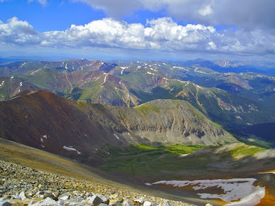
View from the summit of Grays Peak (2010)

I lost my 14er virginity on Grays Peak and even dropped trough on the summit in celebration, but I get ahead of myself. Grays has been the site of many deflowerings because it is an easy Class I (walk up) ascent and is close to Denver. If you tend towards exhibitionism or don't mind sharing your panting climaxes with 200 or so of your fellow adventurers then by all means join the herd and head to Grays and its sister Torreys for your first ascent.

A photo of the route up Grays and Torreys from the 14ers.com website.

I was fortunate in that I took a day off of work back in August of 2006 and so I only had to smoke the proverbial cigarette with 7 other people. I learned a thing or two about mountaineering that day and fell in love with 360° views.

The stream near the trailhead (2006)

The trailhead to Grays and Torreys Peaks is up Steven Gulch Rd off I-70 near Bakersville. Bring a 4WD because the road is filled with SUV consuming potholes. The parking lot is also small, so join the rest of the smart ones and get there before 7am, which brings me to my first mountaineering lesson: Start early. In Colorado, most summer days are filled with afternoon thunderstorms. You really need to consider being off the mountain before 1 PM. If the weather gods are kind, you'll have clear skies and can linger on the summit but don't plan on it. Start out too late, and you will be dodging lighting bolts as you tumble head over heels down the mountain.

The sparse landscape and high valley walls (2010)

The route up these two mountains starts off crossing a small creek and then heads up a broad valley bordered on each side by long ridges. There is not much to see here but some low willows and piles of talus. The route continues this way for quite a while before it finally starts to climb upwards over and around series of large shoulders. It is here that Torreys comes into view since it lies directly at the end of the valley.

The terrain from the end of the valley (2006)

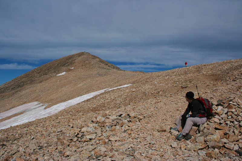
It wasn't until I was past these bumps and entered the many switchbacks that head up the face of Grays did I really consider myself on the mountain. From this point on it is back and forth, back and forth, inching ever higher. Grays is a gray, dreary, monotonous experience. The only view is back down the valley. It is however, an accessible experience for those who want a taste of altitude.

Torreys comes into view at the end of the valley. The route is going to ascend the large pile to the left (2006).

The summit came surprisingly fast and I was suddenly surrounded by views for what seemed to me at the time to be little effort. I immediately had to put on the several layers I fortunately packed in my bag. This was lesson number two: It really is cold Virginia, up there on the craggy bits. Plan for it by bringing layers.

On the slope of Grays, looking back down the valley (2010)

We ate lunch on the summit and then I waited in line for a clear spot for a bio break. My companions were all the way back down to the saddle (at 13,707 ft) between Grays and Torreys by the time the honeymooners near me were done taking pictures and moved off so I could have 30 seconds of privacy. When I was done, I raced down and started up Torreys way too fast as I tried to catch up with my friends. Half way up Torreys, the altitude hit me like a ton of bricks. My vision became blurred and my breathing erratic. Here was lesson three: Don't eat if there is more elevation gain in the schedule. All that blood and oxygen needed to keep your brain functioning goes right to your stomach and is not available for other things like foot placement and lung function. Note honeymooners, the same thing happens during other activities.

Looking over to Torreys. Note we are not alone on the mountain (2010)

The trail up Torreys is a vertical calf-burner with limited switchbacks. It is only 560 feet of elevation gain to the summit, but is slightly more difficult because of the terrain, and the fact you cover this in only 0.5 miles. Anytime you can bag more than one peak in a day, is a good day in the mountains, however, and we were lucky that the weather held and we did not have to head down.

Another view near the summit (2010)

The route down from Torreys is straight forward. Once back down to the saddle there is a spur trail that connects with the trail coming up Grays so it is a simple route. I experienced my fourth lesson at this point of the trail: Going down is not nearly as much fun as going up. Not only is it harder on the legs, but the thrill is gone and there is nothing but the parking lot as motivation. Mountain climbing is the only sport that celebrates at the half way mark. In the case of more dangerous routes, this trend is amusing because getting down is often more life threatening than getting up. I am not in that league, however, so it is more ennui that is the biggest threat to my existence.

My friends on the saddle between Grays and Torreys (Lynn Johnson, 2006)

The slog back down the valley was particularly tedious and I was low on water. Here was my final lesson of the day: On bare mountain slopes there is no water and you have to carry everything you need, which is no fun because water is very heavy.

There is one denizen of the mountain who lives there year round (2006)

As a parting shot (pun intended), I would like to give a note of thanks to the photographers I have so shamelessly stolen from to make this post possible. I climbed these peaks two years before I started this blog and did not bring a camera with me. None of my friends on my ascent took a full trail profile, so I have not been able to blog this popular trail. Recently, however another friend, Sarah Meyer, reached the summit of Grays and took a bunch of pictures that have finally enabled me to share my impressions with my fellow hikers. Her pictures are labeled 2010. The others are given credit if I know who took them, otherwise they are just labeled 2006.

Saturday, September 6, 2008

Summit Lake (Mt. Evans)

Distance: 300ft to 0.25 mile
Elevation: 12,830 ft
Elevation Gain: Negligible


Summit Lake on Mt. Evans

Two years ago, my hiking buddy twisted her ankle and we were moping about wishing we could get into the high country. Alas, we live in Colorado and it dawned us that we could get there the easy way, by driving. I would have much rather have hiked to Summit Lake but what’s a girl to do with her foot in a boot?


View on the drive up to the lake

The road up Mt. Evans is scenic at every turn. Be prepared, however, to pay the $10 fee that the forest service has initiated. I have a friend who is a Ranger on Mt. Evans and he has told me that people are rebelling against this fee and are refusing to pay, saying that they won’t get out of the car. Don’t bother playing this game. You are going to want to get out of the car and a $10 fee is a small price to pay for the extraordinary views that await you.


View of Chicago Basin from the far end of the lake

The lake is only a few hundred feet from the parking lot…easily doable in a boot. We even ventured to the far end of the lake (0.25 miles) to the Chicago Lakes Basin. This view is worth strolling to and if my friend the Iron Maiden can make it, then you certainly have no excuse.


Rocks and peaks from the lake

Be sure to admire the summit of Mt. Evans and Mt. Spaulding that surround the lake and imagine yourself slogging to the summit the old fashioned way.

Thursday, August 14, 2008

Quandary Peak

Distance: 6.75 miles round trip
Elevation: 10,850-14,265 ft
Elevation Gain: 3,450 ft
Dogs: Off leash
Bathroom at Trailhead: No
Date Hiked: 12 August 2008
Tags: #14er, #peak, #mountainpeak, #Breckenridge

Quandary Peak (14,265 ft) viewed from the East Ridge
Quandary Peak near Breckenridge, CO is technically one of the easier 14ers. There is no large talus dome at the top to navigate and minimal exposure. There are also large rock steps placed frequently along the route so that at times it may feel like Stairmaster instead of a mountain. There is, however, a lot of loose skree that will make coming down a chore. Quandary Peak is also known for its numerous false summits.

The lower part of the trail is in the trees.
The elevation gain on Quandary is nothing to laugh at, but given a nice day without pressure from the weather, anyone who has either exercised regularly or who is very determined can achieve the summit.

Quandary Peak look like a giant snowboard ramp. The route stays to the sides of this ramp or ridge rather than ascend directly up the middle of it. Because of this, the views are spectacular the entire way.

Northstar Mountain viewed from the left side of Quandary's ridge
The trail to the summit is low enough that it begins in the trees. It takes you to the right, northern side of the ridge (McCullough Gulch), but then quickly winds back towards the southern side (Monti Cristo Gulch) where it will stay for the rest of the journey.

Monte Cristo Gulch and Blue Lakes
Around 12,000 ft, Blue Lakes deep in Monte Cristo Gulch come into view. This gulch is bordered to the south by a jagged ridge line that joins North Star Mountain to the east and Wheeler Mountain to the west. The dam at the end of the Gulch is the starting point for the West Ridge route up Quandary. This route is much more exposed and should only be attempted by more experienced climbers. At the time of this posting, renowned chef from Missouri died on this route another climber nearly died after a horrible tumble down the Monte Cristo couloir.

Summit viewed from the left
Heading up to the ridge at 13,150 ft
Quandary Peak is unique in that you can see the summit and much of the route from a road that many people travel getting to and from Breckenridge. The sharp rise in the "ramp" is clearly visible and looks enormous.  From its base the summit is only one mile and 1,100 ft of elevation gain away. The trail in this area is still mostly skree but is occasionally dirt. It is here that the false summits begin.

On the East Ridge, a little farther up
On the narrow portion of the ridge
Each succeeding pile of scree blocks the upper portions of the ridge and gives the illusion that it will be the last. Alas, you will be able to see the last pile and the summit just off to the left so until you do, don’t be fooled.

First large scree pile on the upper 1,000 ft
The last false summit
There is no large boulder field at the top of Quandary Peak. The top can be strolled across with ease. The views to the west are by far the most dramatic. Mount of the Holy Cross and Notch Top Mountain can be clearly seen to the west. Closer in, just across the West Ridge is the Fletcher Mountain and the backside of Mayflower Gulch. To the north is the cone-shaped Crystal Peak. To the south is Mt. Democrat, Mt. Lincoln, and Mt. Bross, and can even see some of the trails that connect these three.

The summit is in sight.
The journey down from the summit can be an exercise in drudgery. Loose rock requires more concentration than you would image. A joyous strain may just fill your heart upon reaching terra firma.

View from the summit looking northwest towards Crystal Peak
View from the summit looking at a hiker coming up the West Ridge
Back down, looking at the green hills of Summit County
Hiking to the summit of Quandary Peak will give you a fantastic sense of accomplishment and a great calf workout. It is close to Denver however, so expect crowds.

The trailhead to Quandary Peak is accessible via a normal passenger car. From Breckenridge, drive 8 miles south on CO Highway 9. Turn right (west) on the 850 (Blue Lakes) Road. Drive a few hundred yards and turn right on the 851 (McCullough Gulch) Road. Drive 0.1 mile to the signed trailhead and small parking area.

North Rock Creek Snowshoe

Distance: 4 miles round trip Elevation: 9,180 ft to 9,780 ft Elevation Gain: 600 ft Dogs: Off leash until the wilderness boundary North...