Showing posts with label Yellow Rabbitbrush. Show all posts

Wednesday, April 27, 2016

Tenderfoot

Distance: 2.5 miles round trip
Elevation: 9,256 ft - 9,821 ft
Elevation Gain: 565 ft
Dogs: Off Leash
Bathroom at Trailhead: No
Tags: #dillon, #lakedillon, #summitcounty, #hiking, #coloradooutdoors

The easy Tenderfoot trail offers stunning views of Lake Dillon
The Tenderfoot Trail near Dillon Colorado is a short but scenic outing up a west-facing hillside with "living the dream" views of both Lake Dillon and the Tensile Range. It is great as an after work doggie outing or an early morning stroll before the heat of the day.
The water treatment facility entrance near the parking lot
The road just as it exits the Water Treatment Facility
A first glimpse of Lake Dillon and Peak One in the Tenmile Range
A sure sign of fall in Summit County are the Rose Hips. 
Approaching the official trailhead
To get to the trail, head up highway 6 going to Dillon from Silverthorne. At the last stop light on the top of the hill (Lutheran Church on the left) take a left and then an IMMEDIATE right onto Road 51. A short distance up this road is a large, fenced complex for construction vehicles. On the right, as the road begins to climb, is a small parking area. There is a small sign pointing out the spot. Above the parking area is the Dillon Water Treatment Facility. The route actually starts on that property, so don't be confused.
Close up of the trailhead
Looking south along the rolling hills
Heading upwards
A dirt road exits the facility and heads southward along a now clear cut hillside. Around 0.25 miles is the official trailhead with an obvious U.S. Forest Service sign. From this point the trail heads upwards along the dry slopes of Tenderfoot Mountain.
Yellow Rabbitbrush (Chrysothamnus viscidiflorus) is a late blooming plant that often grows near Sagebrush
A trail segment near a clear cut area
Looking north at the Gore Range
Sagebrush, and Yellow Rabbitbrush dominate the flora for most of the route. Lodgepole pine and Aspen make a showing as well as Lupine in the summer.
Views of Lake Dillon abound on this trail
A Lodgepole segment
Grasshopper identification is not easy. 
An Aspen segment with Lake Dillon in the distance
Looking north from the final bench at 1.25 miles
The end of the trail sign at 1.35 miles
Close up of some Yellow Rabbitbrush
Here are some milestones: 0.69 miles to the first bench, 0.90 miles to a power line tower on the left, 1.25 miles to a final bench, and 1.35 miles to an official "end of the trail" sign.

Saturday, June 9, 2012

Utah: Sego Canyon

Distance: 0.5 miles
Elevation Gain: negligible
Dogs: Allowed
Bathroom at Trailhead: Yes

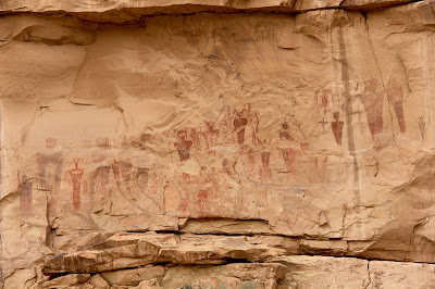
The spooky panel of Barrier Style pictographs found in Sego Canyon.
The spooky panel of Barrier Style pictographs found in Sego Canyon.  Each one of these figures is about three feet tall. 
A trip to Sego Canyon north of Arches National Park in Utah will either have you believing in ancient aliens or wishing you could order a package of whatever the painters were smoking. The cliff faces around the canyon are covered in Indian pictographs, some traditional (e.g. horses and men) and some outright bizarre (the afore mentioned aliens).  I have seen these images on television and the Internet, but nothing compares to seeing them in person.  The alien looking ones in particular are really BIG, which just increases the tingling of the hairs on the back of the neck.

Ute Indian Pictographs.  You can tell it is the most recent because of the depicted horses.
Yellow Rabbitbrush and Sagebrush dominate this shot looking out the canyon
Finding Sego Canyon can be as hard as finding evidence of UFO visitations.  It is not obvious.  Coming from the east, it is one exit beyond the Utah visitor's center.  This exit, for Thompson Springs Utah, dumps you into a town 2 seconds away from total abandonment. Signs hang from their hinges, grass grows in the cracks of the road, and leaves rustle in the corners of the buildings.

To the right of the Ute panel is a panel from the Fremont Period.  This culture pre-dates the Utes.  It is believed these Indians were contemporaries of the Ancestral Puebloans.  
A Plateau Lizard lounges on one of the railings guarding the panels
There is no sign pointing to Sego Canyon and no real indication of where to go.  I bravely drove through town until I found a small BLM sign pointing the way.  It was a total leap of faith to get that far.  Once in the canyon, you arrive at a trailhead with a small bathroom and parking lot.  From there it is a matter of wandering around the small trails in search of the pictographs.  Be aware that the most interesting images are not visible from the parking lot and are in fact on faces "around the corner".

The dark red image on the right is my favorite of the bunch.  Its insect like head is beautiful in a nightmarish sort of way.  Maybe I don't want to be smoking the ancient weed if this is the sort of image my imagination might conjure up.  
Are these images of aliens in space suits?  To the modern eye the appendages could be hoses and antennae.  
The art in Sego Canyon dates from four different periods. The images near the bathroom are from the Ute period (after 1300 A.D). You can tell these are the most recent images because they includes horses, which did not arrive in North America until the Spanish invasion. There is also rock art from the Barrier Canyon period from 4000 to 2000 B.C. and the Freemont period dating from A.D. 600-1250.  The Barrier Canyon art is very unique.  It is concentrated in this area of Utah with some stunning panels in Canyonlands National Park.

In this photo you can see the size of these images which are located across the valley and behind a  livestock corral.  Touching the images is not a good idea.  The oils from the skin can damage the paint.  Note the gun shots of some seriously stupid people with no appreciation for our American Indian heritage.  
The images in Sego Canyon have existed for thousands of years.  It only takes a modern human five minutes to deface them.  The American Southwest is littered with these sites.  Most will hopefully stay hidden for a long time to come.  
At the time of my visit, a large shrub was flowering, spilling its honey like sent into the air.  It was almost intoxicating.  After wandering through the bushes for an hour or so I was starting to get light headed and the figures on the wall were starting to shimmer in the haze.  Hmmmm, was I drunk on nature or had I found that alluring substance I mentioned earlier?  You are just going to have to go to Sego Canyon to find out for sure. 

North Rock Creek Snowshoe

Distance: 4 miles round trip Elevation: 9,180 ft to 9,780 ft Elevation Gain: 600 ft Dogs: Off leash until the wilderness boundary North...