Showing posts with label Sagebrush. Show all posts

Saturday, February 8, 2014

Canyonlands: Murphy Point

Distance: 3.5 miles round trip
Elevation: 6,040 ft
Elevation Gain: 350 ft (cumulative)
Bathroom at Trailhead: No, nearest one is the Visitor's Center
Dogs: No, National Park
Date Hiked: 24 April 2013

Looking west and down, down, down, from Murphy Point in Canyonlands National Park
The trail to Murphy Point in the Islands in the Sky section of Canyonlands National Park is one of the few longer hikes one can take and still stay on the mesa. It traverses sand and slickrock with ever-changing, end-of-the-world views. Be forewarned! Looking off into that abyss is a transcendent Ozymandias kick in the solar plexus. One's whole life is reduced, in the casual stirrings of the desert wind, to meaningless drivel. Our weak brains can't even register the scale of the scenery without reducing it to a theatrical canvas backdrop. Your only hope is bring along sufficient chocolate chip cookies to stay grounded. A prolonged astral projection on Murphy's Point might just prove to be fatal.

Starting off in the deeply rutted road
Stay to the right here
Sagebrush
The trail to Murphy Point begins 8.6 miles south of the Visitor's Center along a deeply eroded dirt track that looks like it was made by a column of 10,000 cattle all racing to the edge of the world. A half a mile in the route splits. Stay to the right or end up on the much longer Murphy Loop/Hogback Trail, which descends off the mesa into eternity returning a few geological ages later.

Looking northwest at the rock formations obscured by haze
That is a cairn in the distance
After the dirt road, the route eventually switches to an easy "find the next cairn", slickrock trail along a narrowing neck of earth. Utah Juniper and Sagebrush dot the landscape and occasionnaly obscure the views. You can wander all over the area but realize there is nothing but 1,500 ft of open air between you and an "oh heck" moment.

Floating over the desert landscape
Sitting at the point looking down on the Murphy Hogback (that narrow elevation portion). You can see the  Murphy Trail as it travels out and around the area. Bring lots of water if you venture that far. 
I did not go anywhere near the edge and so arrived, sanity intact. We had the entire place to ourselves, which is always a treat. Canyonlands is big and it is easy for folks to spread out...and never to be heard from again...at least until the chocolate chip cookies run out. Then they congregate back at the Visitor's Center where they gobble up T-shirts and refrigerator magnets. So plan ahead and stay awhile at the end of the trail. It is not often we get to transcend our banal existence for something the truly sublime.

Saturday, June 9, 2012

Utah: Sego Canyon

Distance: 0.5 miles
Elevation Gain: negligible
Dogs: Allowed
Bathroom at Trailhead: Yes

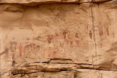
The spooky panel of Barrier Style pictographs found in Sego Canyon.
The spooky panel of Barrier Style pictographs found in Sego Canyon.  Each one of these figures is about three feet tall. 
A trip to Sego Canyon north of Arches National Park in Utah will either have you believing in ancient aliens or wishing you could order a package of whatever the painters were smoking. The cliff faces around the canyon are covered in Indian pictographs, some traditional (e.g. horses and men) and some outright bizarre (the afore mentioned aliens).  I have seen these images on television and the Internet, but nothing compares to seeing them in person.  The alien looking ones in particular are really BIG, which just increases the tingling of the hairs on the back of the neck.

Ute Indian Pictographs.  You can tell it is the most recent because of the depicted horses.
Yellow Rabbitbrush and Sagebrush dominate this shot looking out the canyon
Finding Sego Canyon can be as hard as finding evidence of UFO visitations.  It is not obvious.  Coming from the east, it is one exit beyond the Utah visitor's center.  This exit, for Thompson Springs Utah, dumps you into a town 2 seconds away from total abandonment. Signs hang from their hinges, grass grows in the cracks of the road, and leaves rustle in the corners of the buildings.

To the right of the Ute panel is a panel from the Fremont Period.  This culture pre-dates the Utes.  It is believed these Indians were contemporaries of the Ancestral Puebloans.  
A Plateau Lizard lounges on one of the railings guarding the panels
There is no sign pointing to Sego Canyon and no real indication of where to go.  I bravely drove through town until I found a small BLM sign pointing the way.  It was a total leap of faith to get that far.  Once in the canyon, you arrive at a trailhead with a small bathroom and parking lot.  From there it is a matter of wandering around the small trails in search of the pictographs.  Be aware that the most interesting images are not visible from the parking lot and are in fact on faces "around the corner".

The dark red image on the right is my favorite of the bunch.  Its insect like head is beautiful in a nightmarish sort of way.  Maybe I don't want to be smoking the ancient weed if this is the sort of image my imagination might conjure up.  
Are these images of aliens in space suits?  To the modern eye the appendages could be hoses and antennae.  
The art in Sego Canyon dates from four different periods. The images near the bathroom are from the Ute period (after 1300 A.D). You can tell these are the most recent images because they includes horses, which did not arrive in North America until the Spanish invasion. There is also rock art from the Barrier Canyon period from 4000 to 2000 B.C. and the Freemont period dating from A.D. 600-1250.  The Barrier Canyon art is very unique.  It is concentrated in this area of Utah with some stunning panels in Canyonlands National Park.

In this photo you can see the size of these images which are located across the valley and behind a  livestock corral.  Touching the images is not a good idea.  The oils from the skin can damage the paint.  Note the gun shots of some seriously stupid people with no appreciation for our American Indian heritage.  
The images in Sego Canyon have existed for thousands of years.  It only takes a modern human five minutes to deface them.  The American Southwest is littered with these sites.  Most will hopefully stay hidden for a long time to come.  
At the time of my visit, a large shrub was flowering, spilling its honey like sent into the air.  It was almost intoxicating.  After wandering through the bushes for an hour or so I was starting to get light headed and the figures on the wall were starting to shimmer in the haze.  Hmmmm, was I drunk on nature or had I found that alluring substance I mentioned earlier?  You are just going to have to go to Sego Canyon to find out for sure. 

Wednesday, June 15, 2011

Sagebrush

Sagebrush (Artemisia tridentata) blankets much of the state. This example is from the Dolores River Canyon.

Sagebrush (Artemisia tridentata) is like skier traffic on I-70, you can't escape it. Every semi-desert or seemingly arid part of the state is covered with this low shrub that can grow to up to 10 feet tall. Not as fragrant as the herb, this plant, never-the-less, will exude a strong scent, particularly when wet. Don't let this "odeur" attract you to a midnight roll in the proverbial hay. Sagebrush can cause dermatitis in humans who are highly allergic to it.

A close up of the leaves. Sagebrush is a popular color in western motifs.

North Rock Creek Snowshoe

Distance: 4 miles round trip Elevation: 9,180 ft to 9,780 ft Elevation Gain: 600 ft Dogs: Off leash until the wilderness boundary North...