Showing posts with label Piney Lake. Show all posts

Saturday, August 2, 2014

Upper Piney River

Distance: 6.4 miles round trip
Elevation: 9,350 ft - 9,910 ft
Elevation Gain: 851 ft (cumulative)
Bathroom at the Trailhead: Port-o-lets
Dogs: On leash, Eagles Nest Wilderness
Date Hiked: 13 July 2014

Cow Parsley along the side of Piney Lake on the Upper Piney Lake Trail.
Upper Piney River Trail in the Eagle's Nest Wilderness out of Vail has views that will make you hyperventilate. The route starts at Piney Lake, one of the highest lakes in Colorado you can drive to, and heads towards the Gore Range's "Grand Traverse", a series of jagged peaks reminiscent of Wyoming's Grand Tetons. Getting to the trailhead, however, is an hour-long journey (at 10 mph) up bumpy dirt road, passable, but not fun, in a 2WD vehicle.

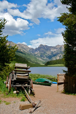
Parking lot at the Piney River Ranch. The trail starts at the lake.
The start of the trail
To get to the Piney Lake, take exit 176 off of west bound I-70 to the frontage road, then turn right onto Red Sandstone Road. A short distance up Red Sandstone, and at a hair pin turn, Forest Service Road (FSR) 700 splits off to the left. This intersection is disconcerting because the paved road whips to the right and the dirt road is straight across. What you don't know, because you come up too fast, is that there is a stop sign for cars coming down Red Sandstone Rd so it is safe to cross. FSR 700 is a long and rocky dirt road that will make you wonder where on earth you are heading. It twists and turns, goes up and down, and splits in several locations. At every intersection is a sign pointing the way to Piney River Ranch, located at the lake, so you should not get lost. At 6.7 miles you'll pass the trailhead to Lost Lake, another nice hike in the area.

Past the lake the valley becomes a verdant marsh.
Fairy trumpets along the trail
Once you get to the Piney Lake there are two parking lots. The one closest to the lake is technically on private property. Since we spent half of our inheritance on some cold drinks after the hike, I did not mind using the lot.

Entering the Aspens
The trail leaves the valley floor and winds up the left side with views of the rocks ahead.
The trail starts right at the lake and heads along the shoreline. At 0.4 miles you enter the Eagle Nest Wilderness. Take a moment to gasp at the view.  Once past the lake, the trail looks down on a verdant marsh. Upper Piney River winds lazily in one continuous S-curve down the valley. Just looking at that peaceful setting made we want to slow down, take deep breaths, and sigh. Isn't it amazing how much effect water has our psyche? 

Looking down on the marsh as the trail begins to ascend
Getting close to the end of the valley
Also in this area is the Marmot gauntlet. There were large boulders overlooking the marsh every 20 yards. Each one had a Marmot family on it with you-tube cute youngsters peaking out from every crevice. Check out these baby Marmots from the American Basin Trail.

After the trail shifts to the right, the terrain is filled with large boulders.
The falls that is the destination of this hike
At 1.0 miles the trail starts to leave the valley and head into the trees. From this point onwards, the trail winds in and out of Aspens as the valley narrows toward a rock wall. At 1.4 miles the trail starts to gain altitude in a series of switchbacks. You know you are getting close when the trail turns sharply to the right at the back of the valley.

At 3.2 miles the trail appears to dead end into a flowing cascade. Follow the social trails to the right to a series of boulder overlooking the torrent. Supposedly an indistinct trail continues for another 4 miles to Upper Piney Lake.

Looking back down the valley near the falls
I have been wanting to do this trail for the last 4 years, ever since we popped up to Piney Lake after hiking to nearby Lost Lake. I had to wait until my dog was old and calm enough to keep on a leash...still not easy! You may not have the restriction, so hold on to your fillings and brave FSR 700, the views are worth it and so much more!

Wednesday, July 21, 2010

Piney Lake


Tags: #mountainlake, #coloradooutdoors, #hiking, #canoeing, #gearguide
Hikes: Upper Piney RiverLost Lake
Critters: Marmot

Scenic Piney Lake
Piney Lake, near Vail, Colorado is one of the highest lakes in the state that you can drive to. There are several trails that leave from the area including Lost Lake which is on the way, and Upper Piney River, which leaves from the parking lot of the Piney River Ranch, a commercial outfitter at the lake. The outfitter has a limited restaurant (no ice cream!!), lodging, and canoe rentals for around $20/hour.

Is this not a classic Colorado tableau?
Piney Lake is accessed 12 miles BEYOND THE END of Red Mountain Road on the north side of I-70 in Vail. The route is over a rough dirt road that is passable in a passenger car if you go slow. It will take at least a 40 minutes if not more to get there depending on road conditions.

Directions: From I-70, take Exit 176 for Vail. Take the North Frontage Road west to Red Sandstone Road. Turn north here and follow the paved road about 0.7 miles to a fork with a dirt road on the left. There should be a Forest Service sign indicating this is Red Sandstone Road #700 (Reset your odometer here). Continue up this road about 2.7 miles to an intersection with the Lost Lake Road (#786) and continue left. At mile 6.5 you will pass Red and White Mtn Road-FSR 734. At mile 6.7 you will pass the Lost Lake Trail parking lot on the right and then reach an intersection where the Muddy Pass/Moniger Road goes left. Stay right here. (Some maps show the Red Sandstone Road changing number from FSR 700 to FSR 701 at this point, and some don’t, but regardless, you stay right to get to Piney Lake and the Upper Piney River Trail). At mile 9.1, you will cross the Piney River and see a trailhead for Lower Piney River Trail - FDT 1885 on the left. Stay right and reach a Forest Service parking lot on the right at mile 10.65 before the entrance to Piney River Ranch.

The outfitter

Friday, July 16, 2010

Lost Lake (near Vail)

Distance: 7 miles round trip
Elevation: 9,611 ft - 10,323 ft (max), 10,200 ft (at the lake)
Elevation Gain: 712 ft (net) 1,082 ft (cumulative)
Dogs: Off Leash

Lost Lake near Vail Colorado is a great hike for dogs
Serene Lost Lake
In my eternal quest to find Forest Service trails where we can let Ginger, the hyper one, run off leash, I discovered Lost Lake (one of the many with that name in the state) above Vail. The route to the trailhead alone was fun as it travels up a bumpy dirt road on the north side of Vail Valley. Wildflowers covered the green hillsides and verdant meadows appeared out of no where along the way.

While mostly in the pines, the trail did contain some Aspen
Heartleaf Arnica and Lupine
The trail itself traverses a ridge covered in Ponderosa Pines and occasionally Aspen. Having never done the trail before I was fearful there would be no views but this is not true. At 1.8 miles, there is a social trail heading off to the right with deep-sigh views of the Mount of the Holy Cross. It looked much larger from this vantage point than it did from Game Creek, which I found very interesting because I could see the Game Creek area across the valley. A little farther up the main trail, and there is an area of clear cut that also allows you this view.

A blanket of Heartleaf Arnica
Looking southeast at the Mount of the Holy Cross
I was enthralled by the carpet of Heartleaf Arnica and Lupine that blanketed the stark forest floor with blinding color. With all that yellow, the dead Ponderosas were hardly noticeable. My Id wanted to romp through them with wild abandon, but alas I figured the sight of a middle-aged woman frolicking in flowers would scare the local wildlife.

A trail segment after the big views showing a young pine forest
Two trail segments showing the pine forest and easy-going dirt trail

There is a small (200 ft elevation gain) hump in the middle of the trail. The descent from this small hill provides phenomenal views of the back side of the Gore Range. That was another pleasant surprise.

The view of the Gore Range from part-way down the small hill
The turn off to the lake
The lake itself does not have any dramatic background, but it was incredibly serene. There were large logs to sit on and eat lunch, and the seclusion was only marred by the occasional Jay trying to get to our sandwiches.

Views of Lost Lake

All in all, Lost Lake is a pleasant excursion particularly on a day when getting above treeline is problematic. That was another reason I chose this trail. The storms were going to start early. If you do go to Lost Lake, be sure to take the additional 15 minute drive and visit Piney Lake. The scenery there will knock your socks off.

North Rock Creek Snowshoe

Distance: 4 miles round trip Elevation: 9,180 ft to 9,780 ft Elevation Gain: 600 ft Dogs: Off leash until the wilderness boundary North...