Distance: 13.6 miles round trip via Ouzel Falls or 12.2 miles round trip via the fire trail
Elevation: 8,500 ft -10,574 ft
Elevation Gain: 2,074 ft net, 2,318 ft cumulative
 Thunder Lake
I confess that I was
trepidatious about hiking to Thunder Lake in Rocky Mountain National Park. Ten miles with a heavy pack and stiff boots is a haul. 14 miles seemed overwhelming. On top of that, I was mobilized with the National Guard for the two weeks prior in support of the Democratic National Convention. I worked nights and did not get a chance to exercise. Not what I prefer to do before a death march.
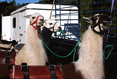 Getting the Llamas ready to go
My friends saved me, however, by bringing Llamas along to carry a huge potluck lunch and all our gear. All I had to do was carry one liter of water and my camera. I even wore lighter boots since I was carrying no weight. The trail itself is a gradual climb with only a few short stints of quad busting effort. By the end, the distance did not seem so bad, which tells you how much pack weight affects the body.
 View of the trail
Thunder Lake is a pretty destination that everyone should do at least once. It is surrounded on two sides by crenelated ridges and on the other two sides by large grassy meadows. The downside of the lake, however is that there is no place to sit and lounge near the lake itself. You can walk down to the shoreline and bushwhack through the shrubbery to view the lake but there is no place to sit. We ended up having our party on the porch of the backcountry cabin that looks out onto one of the meadows.
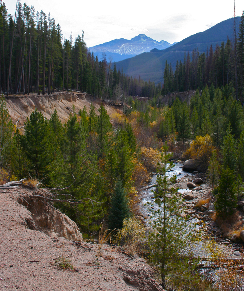
 Stream along the trail
 Llamas crossing a stream
There are two routes you can take to Thunder Lake, both start in the Wild Basin side of Rocky Mountain National Park. The most common route takes you by the Calypso Cascades and Ouzel Falls. While adding some variety, it is also 0.7 miles longer. On this trip we chose to take the fire trail by pass instead. This trail is steeper and rockier but also shorter. We did this not only to save mileage on the long hike, but also to minimize pedestrian traffic for the Llamas. Be advised that this route is in the trees the entire time with only occasional brief glimpses to the south of Meadow Mountain (11,634 ft) and St. Vrain Mountain (11,391 ft). The views do get better for the last two miles with occasional stream crossings to lighten the mood.
 Farther along the trail
 The ranger cabin with the lake in the background
If you have not been to Wild Basin in a while, you will notice that the National Park Service has improved the parking situation. In addition to more parking slots, there was a small army of volunteers telling you precisely where to park. The lot, while large, does fill up by 9:30 on the weekends so get there early if you want a spot.
 Thunder Lake
 Meadow as seen from the cabin
Despite a forecast with a low probability of rain, it rained the entire way back to the car. My Marmot raincoat leaked like a sieve and I was soaked through. This is my second rain jacket. The other one, an REI brand also leaked badly. My friends did believe when I say this happens. Am I cursed or have others run into leaky jackets? For several hundred dollars, I expect more.
 The right side of the lake
Traveling with Llamas was a hoot. Each one has a unique personality and facial expressions. I enjoyed watching their feet as they walked. They have soft pads on the bottom of their feet, which makes them ideal wilderness packers. Their impact is less than a hiking boot and their hooves are so small that they are comical in appearance. They would hum when not together as if whining for their buddies. As members of the camel family, they don’t drink much water and did not eat the grain that was brought along for them. They can carry a third of their body weight, roughly 50-75 pounds, and will literally crawl into your minivan. The gal who owned these Llamas does not own a commercial business but loans them out to the Forest Service. If you find a commercial outfitter, they run about $50/day per Llama.