Wednesday, July 31, 2013

Black Powder Pass

Distance: 3.4 miles round trip
Elevation: 11,482 ft - 12,159 ft
Elevation Gain: 677 ft
Bathroom at Trailhead: Yes, in one of the out building for the Section House
Date Hiked: 26 July 2013
Dogs: Off leash
Tags: #hiking, #coloradooutdoors, #mountainpass, #gearguide


Looking east from Black Powder Pass near Breckenridge CO
The view looking east from Black Powder Pass
Black Powder Pass off of Boreas Pass near Breckenridge Colorado is a stunning destination that will take the hiker above treeline, along a flower-lined ditch and up to a verdant meadow filled with willows, flowers, and slap-your-mama views. Even better, this trail is short and therefore accessible to those who don't do Ironman Triathlons every other week.

Section House is a ski hut in the winter. That is Bald Mountain in the background.
The start of the trail is just a small National Forest Service sign
You get to the trailhead from Boreas Pass. This is the top of Boreas Pass Road, which starts on the south end of Highway 9 just as it leaves Breckenridge. It is 9.2 miles from the turn off on Highway 9 to Boreas Pass and most of the route is on a graded dirt road passable with a 2WD low clearance vehicle.

Starting out along the ditch
This one talus field is the only tricky obstacle on the trail.
Once at the pass, the trail begins at a numbered Forest Service trail sign just before the Section House, a 1900's building now used as a hut in the winter. The first 0.7 miles of the trail is along a Boreas Ditch 2 and its occasional water control gates and pipes. Wildflowers galore line the banks and the trail bisects and travels on both sides of the ditch. Don't worry both lead to the same destination.

This Hoary Comma (Polygonia racilis) landed on a Chimming Bell on the Black Powder Pass Trail Colorado
A Hoary Comma (Polygonia gracilis) butterfly landed briefly on this Chiming Bell just as I passed by.
Breaking out of treeline. The pass is visible in the distance.
At the end of the ditch, the trail bisects again with the right hand route going steeply up hill along a highly eroded segment. The left hand route, which we took on the way back, travels through willows and over roots. Either side will take you above treeline.

View of Quandary Peak and the Tenmile Range
Looking up at Mt. Baldy
Once out of the trees, the ridge to Bald Mountain on the left comes into view and views of the Tenmile Range dominate the west. The route gets steep at this point and heads steadily upwards through open tundra to the left of the creek that feeds Boreas Ditch 2. King's Crown, Queen's Crown, Harebell, Parry Primrose, Chiming Bells, Columbine, Elephant Head, Indian Paintbrush, Bistwort, Monkshead, and Purple Larkspur were just some of the flowers we saw along the way.

Standing on the pass looking south to Boreas Mountain
Wildflowers growing on the backside of the pass
Once at the pass, the trail itself goes over to a view spot looking down on South Park, Georgia Pass , and the route to French Pass on the tall ridge directly ahead. The rugged rocks of Boreas Mountain form a wall to the south. If you are going to climb Boreas Mountain, however, don't start from Black Powder Pass, but jump to the ridge directly from behind Section House.

Wildflowers encroaching on the trail
While short, this trail is still at altitude and after being gone from Summit County for several weeks, I found myself sucking wind as I approached 12,000 ft. Still, if you take your time, even folks with moderate levels of fitness should be able to make the pass. The view down the backside is well worth the effort. If you are a fit local, there is now excuse not to pop up to the left ridge for an ascent of Bald Mountain.

Wednesday, July 17, 2013

Lower Straight Creek

Distance: 4 miles round trip (much further possible)
Elevation: 9,385 ft-9,885 ft
Elevation Gain: 500 ft
Bathroom at Trailhead: No
Dogs: Off leash
Date Hiked: 1 July 2013

One of the open meadows along the lower portion of the Straight Creek Trail
So why you ask would any outdoor lover worth their Nalgeen bottles want to hike on a dirt road that parallels noisy, dirty, aggravating I-70? Because sometimes we humans sacrifice our sensibilities for our four-legged companions who don't like to stay on the trail, disregard wilderness boundaries, and otherwise make a nuisance of themselves. For those reasons, Lower Straight Creek is an ideal guilt-free afterwork outing.

The trailhead.  The route starts at the gate on the left
Crossing Straight Creek
The Forest Service says that to get to the trailhead, take exit 205 off of I-70 (Silverthorne/Dillon) and travel south on highway 6 toward Dillon. In approximately 1.2 miles turn left at the traffic intersection of Hwy 6 and Evergreen Road. Then make an immediate right onto County Road 51 and follow this for approximately 1.7 miles until it ends at a gate and the trailhead parking area.

The Straight Creek Trail is an old road so it is wide and rutted in parts
A truck cruises by along I-70
The Straight Creek Trail parallels I-70 the entire way up to Eisenhower Tunnel but I only went up 2 miles. Because of recent clear cutting, there are some wide open expanses jealously guarded by Marmots and a few darker, more confining segments that at times felt downright primeval. In the more open areas are some nice views of Buffalo Mountain.

Looking back at Buffalo Mountain
I-70 is, as you might expect, very close but up 300 ft-600 ft berm and at times much lower but further away. I paid close attention to Ginger, the hyper one, to make sure she stayed away. Fortunately, the shrubs, trees, and critters near the creek were far more enticing.

Ginger searches for critters in the downed trees.  Even after this outing, she still got me up at 6am to go again. Geesh!
Be aware that the trailhead serves two trails. Lower Straight Creek starts across the bridge to the left.  South Straight Creek starts on the right hand side of the creek.

Thursday, July 11, 2013

Herman Lake

Distance: 7 miles round trip
Elevation: 10,332ft - 12,018 ft
Elevation Gain: 1,815 ft (cumulative)
Bathroom at the trailhead: Yes
Dogs: Sign says on leash, forest service website does not indicate this restriction
Date Hiked: 22 June 2013

Herman Lake in Colorado can be found at the end of a steep trail that starts one exit before the Loveland Pass Ski area on I-70.
The partially frozen Herman Lake
A trip to Herman Lake near the Eisenhower Tunnel can be an arduous slog up steep and unrelenting pitches or a stroll in the proverbial meadow depending upon who you dreamed about the night before or if it took you an extra five minutes to find your car keys. In other words, fitness level and mental fortitude seem to have nothing to do with this trail, which is always harder than it should be. I don't mind a little mountain masochism, but all that gasping and quad burning should come with a greater reward than a mere lake no matter how pretty. That is just me. For the rest of humanity however, Herman Lake is close to Denver and as I have said is rather pretty. That means you will be trudging along with 10,000 of your closest friends each of whom will have brought a dog. Bring along a espresso cart and you might just make your fortune.

The trailhead and all the cars
An example of a steep initial pitch. This early portion of the trail goes up 700 ft in 0.7 miles.
The trailhead for Herman Lake is fortunately large enough to handle the crowds and is located at exit 218 off of I-70 just before the Loveland Ski area. The trail is notorious for its initial ascent up a very steep rocky road that will cause blurry vision and apoplectic fits if you start out too fast. Pace is the key to surviving Herman Lake.

Raging spring runoff
One of the open meadows
The trail slips in and out of shaded forest and open meadows as it climbs steadily upwards. There are a few stretches that are flatter and on this trip we saw more than one family sprawled gratefully along these areas trying to catch their breath.

Looking back down on the route
Finally breaking above treeline at 3 miles
There are mountains on both sides of the trail and all those lovely views provide a more socially acceptable reason to stop, breath, and gawk. A voracious stream parallels the trail and at times adds riparian splendor to the area. Snowfields can linger late in the season and the lake can be quite frozen into the early part of July. It is only in the last three quarters of a mile that the trail breaks above treeline and it is here that the final pitch begins. Remember to pace yourself. It is further to the lake than it seems from below.

Dang, still not to the lake and still going up
The final pitch to the level of the lake
Herman Lake itself is nestled against the Continental Divide and after all that effort I always have always had the desire to pop up to the ridge and explore. Afternoon thunderstorms, which are notorious in this area, have always prevented me. Good excuse huh?

At last on the level of the lake, but there is still a ways to go across the snowfields
Don't be fooled the real lake is much larger.
Herman Lake like Lake Ann and Ptarmigan Lake is a quintessential mountain tarn. In spring the area is filled with wild flowers and snowfields dot the landscape. If you can muster the mental energy to fight I-70 traffic and the wicked ascents, you will be well rewarded.

This lounging hiker stole MY favorite rock.  It was way to nippy at the lake for sun bathing. Are they passed out from exhaustion?
The sun came out, the air warmed, and snoring began in ernest!

Wednesday, July 3, 2013

Angler Mountain Trail

Distance: 4.4 miles round trip to Ptarmigan Trail, 5.4 miles round trip to Bench
Elevation: 8,542ft -10,112ft
Elevation Gain: 1,571 ft (cumulative)
Date Hiked: 29 June 2013
Bathroom at Trailhead: No
Dogs: Off leash

View of the Tenmile Range in Silverthorne Colorado.  Viewed from the Angler Mountain Trail.
The Tenmile Range and open verdant meadows are only some of the attractions on the Angler Mountain Trail
In summer, the Angler Mountain Trail in Silverthorne, CO will make your eyes pop with the number and variety of wildflowers that dot the route. In the more forested sections Colorado Columbine fill every nook and cranny while on the more open Sagebrush hillsides Lupine, Scarlet Gilia, Blue Flax, Pontentilla, Cushion Buckwheat and many more ebb and flow with each undulation of the terrain. What is also amazingly fun, is the first mile of the hike contains placards identifying these flowers as well as the local trees and shrubs.

The Trailhead
The initial steep hillside.  Elevation gain is a consistent 500ft/mile.
The overall route is on the east side of Highway 9 and takes the hiker up and down verdant hills while slowly gaining altitude. The trail ends with its intersection with the Ptarmigan Trail and from this intersection it is only 0.5 miles to the Ptarmigan Bench, a series of logs in an open clearing with stunning view of the Gore Range.

Heading into an Aspen Grove
Wildflowers line the trail
Angler Mountain is relatively new trail and therefore not any of the maps you are used to looking at. The trailhead is located within the Angler Mountain Townhomes off Bald Eagle Drive in north Silverthorne. Take Bald Eagle Drive at The Ponds, cross the Blue River, and continue around the townhomes to the south and the prominent trailhead. The route starts sharply up a dry Sagebrush hillside and then proceeds to go up and down similar hills, some dry, some covered in young Aspen trees, and some shaded by Lodgepole pines.

Another open Aspen Grove
Approaching the new road at 0.7 miles
The early part of the trail winds through homes being built in the area and crosses a new road at 0.7 miles before gradually tapering off into more pristine areas.  At 1.8 miles the route reached the top of another hill and looking down the other side, the trail seemed to end abruptly at the bottom. I stood there staring for a while because I knew the trail continued having seen its apex on the Ptarmigan Trail but I did not want to descend only to find I had taken some wrong turn somewhere and was on the wrong trail. Finally, I descended the hill to find the trail continued but was totally hidden by the shrubs.

This pleasant Aspen tunnel was the gateway to the  wilder  meadows in the upper reaches of the route. 
Views of the Gore Range abound
After winding 2.2 miles and 1,216 ft up to the Ptarmigan Trail, I decided to head to the Bench, which I thought was only a hundred yards or so further on. It was in fact 0.5 miles.

Heading off into the more open expanses
Lupine line the trail
Despite the few forested sections of the trail, there is very little shade on this route, which made for a hot, dry climb. If you can, start earlier in the day to avoid the heat and the afternoon thunderstorms which build behind the Gore Range and come rumbling eastward as the day progresses.

A sharp switchback heading up another hill with more views of the Gore Range
One of the final pitches to the Ptarmigan Trail

Thursday, June 27, 2013

Capitol Reef: Waterpocket Fold Tour and Hike

Distance Road Tour: 125 miles (just the loop), 6 miles out and back (overlook parking lot)
Distance Hike: 0.5 miles round trip

The Waterpocket Fold in Capitol Reef National Park will make you want to become a Geology Major.  It is that cool!
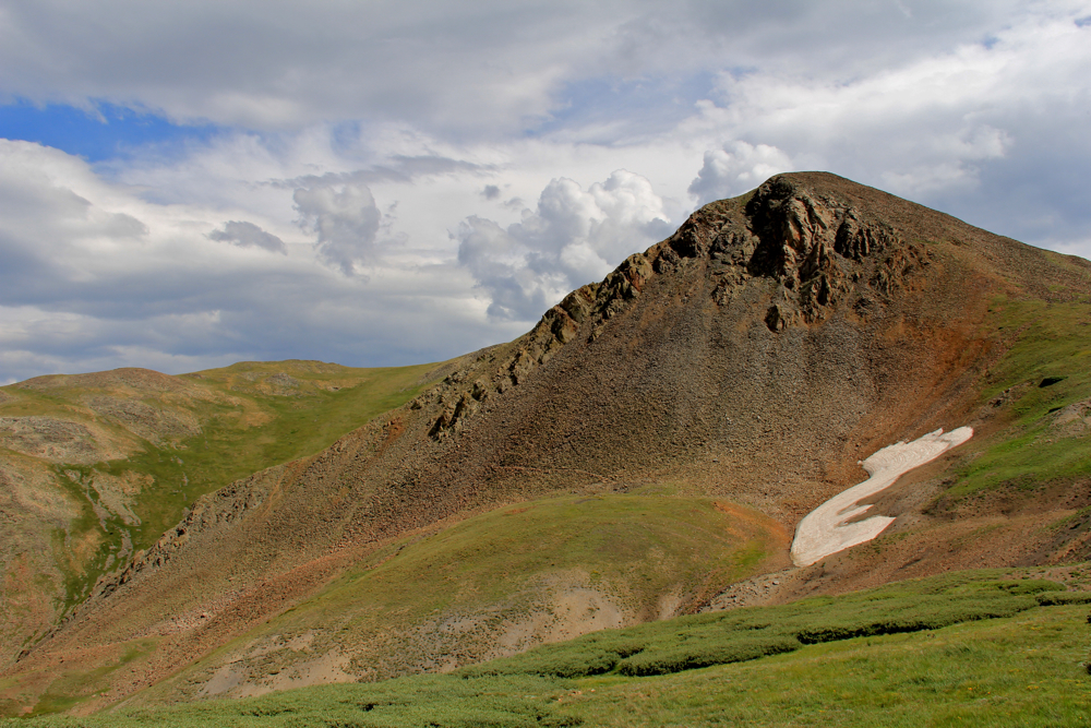
Looking south along the Waterpocket Fold from the Strike Valley Overlook
There are three scenic drives in Capitol Reef National Park. One is a short meander in the main tourist area of the park and the other two are back country drives (Cathedral Valley and the Waterpocket Fold) over potentially rough terrain. Since the park itself exists because of the latter, we brought along the 4x4 truck, loaded it with the recommended emergency gear, and headed out on a geological journey par excellence.

This driving tour travels straight down the fold where towering sandstone cliffs dominate the western horizon, up a nail-biting series of switchbacks, down a true 4x4 side trip to the Strike Valley Overlook (an unofficial detour), and a serene drive through Juniper plateaus; stunning canyons; and Aspen covered mountains.  It is an all day adventure that will have you amazed at the diversity of terrain in Utah.

Route of the drive.  The Strike Valley Overlook is in the red box and the purple "Aspens Galore" mark the upper mountains.
First the obligatory geology lesson. Pretend you are a kid again making a layer cake with your grandma-ma. Not content with a few layers, you pile on layers of cake and icing and cake and icing making sure that each layer is a different color.  In some layers you add small nuts or M&Ms so they really stand out. That is essentially what happened in what is now western North America over millions of years. As the continents drifted across the globe, the environment changed and layers of "dirt" (sediment) were laid down one on top of each other. Some layers came from marshy mud-filled lagoons (grey) and others from giant Sahara-like deserts (white).  Still with me?  Believe me, if you visit this area you will want to quite your job and get a Phd in Geology.  It is that cool!

So now you have this monster-sized layer cake.  Imagine that after you bake it all those layers get stuck together and the whole thing becomes like a slinky able to bend and twist. When a slinky goes down stairs it forms a monocline, a fancy geological word for a slinky going down a stair.  Seriously, it means a bunch of layers that form a linear stair step, where one end is higher than the other (see technical diagram). This is what would happen if a rambunctious Labrador came crashing into your layer cake and crunched one side of it. In the case of Capitol Reef the Labrador was a really big tectonic plate that scrunching everything in its path.  Kaboom! Note that in geological time that is really more like KKKKKKKKKKK aaaaaaaaaaaaaaaaa bbbbbbbbbbbbbb oooooooooo ooooooooooo mmmmmmmmmm over millions of years but it is still pretty dramatic.

Diagram of a Monocline, and vertical drop in sedimentary layers.  In Capitol Reef, the left side of the diagram would the the 11,000 ft mountains, while the slope is the Waterpocket Fold.
Back to the kitchen.  At this point all you see is the upper most layer of the cake (the chocolate icing) in a stairstep on the floor were Rex scrunched it. Not terribly interesting. While Grandma-ma was not looking, however,  you decided to take a garden hose to the cake to see what would happen. You pour water on the upper part of the cake and watch it cascade downwards. Wonder of wonders, over time, the water starts to peel away the various layers underneath, so you can see those M&Ms and the other colored layers. That is what the Waterpocket Fold is all about. Rain in the 11,000ft mountains (where the Aspens are on the map) poured down the Fold and eventually eroded the top layers so that all the interesting stuff was exposed. The driving tour takes you parallel to the scrunch, up the far side (all the way to the mountains) and back down again. If you area scenery buff, there is definitely a wow factor in all of this.

A typical early segment with a nice, smooth dirt road and different layers on either side. That is the Chinle Formation on the left.
We took the drive counterclockwise (see map) and headed out on a pleasant dirt road that traverses ranch land before diving down into the Strike Valley (e.g. the scrunch where things go vertical). In this area the layers now lay left to right across the road so that on the left might be the M&M layer (actually the Chinle formation with its various shades of green and gray), while to the right is  is bright yellow layer, and finally the Navajo Sandstone layer, which forms THE WALL of the scrunch. All of this may sound terribly boring, but it is really mind-blowing. The colors, the immensity of THE WALL, and the shear other worldliness of it all will have you running around like a kid spouting scientific terms like "formation", "hoodoo", "hogback" etc.

On the right hand side of the road were these yellow layers
The next part of the route is up the infamous Burr Trail Switchbacks. While the dirt road that ascends THE WALL is wide, there is no guard rail and each turn is an exercise in Lamaze breathing. Going up is apparently less nerve wracking that going down. We talked to some folks in a jeep who did both and almost converted to Catholicism they were praying to the Virgin Mary so hard as their tires slide on the loose gravel. I had been nervous about this segment but going up was less scary than anticipated and over in a few minutes. At the top of the switchbacks is an overlook. Stop there to catch your breath if nothing else.

Looking north along THE WALL
Looking straight across to the wall, which is several thousand feet high.
Around two miles beyond the overlook is a turnoff to the Strike Valley Overlook. To get there, you can hike three miles up a desert wash or drive it in your 4x4. While no other part of this trip really required high clearance, this segment did. The wash was sandy, rocky, and narrow. Driving down it, I was glad we had packed our camping gear in case we had to stay there a few months until rescue. Alas at the end of the road was a large parking lot filled with other 4x4s, coolers with beer, and lots of folks who could have saved us. Most of the folks were heading up canyon. We were the only ones who took the short 0.25 mile jaunt to the Overlook. Never in my life have I worked so little for a view so grand. Looking down into the Waterpocket Fold may just be the most stunning view I have ever seen. Who knew the desert could be so awe-inspiring.

A shot of the switchbacks through the front window
After our trip to the overlook, we continued on the drive, which traversed a high,  Utah Juniper covered plateau before plunging into the Grand Staircase Escalante and another stunning red rock (e.g. Wingate Sandstone) canyon. In the town of Boulder we stopped for a bio break and coffee before turning north.

Looking north at the Waterpocket Fold from the Strike Valley Overlook
The segment of the drive between Boulder and Torrey was a complete surprise. On the map you don't realize how high you are climbing and we drove through the largest Aspen grove I have ever seen.  There were no leaves on the Aspens in May but I kept picturing it in the fall. It would be intoxicating.

A welcome surprise during the drive was this canyon traverse. 
So, you can probably tell by now that I was impressed by this experience.  A few logistical notes.  You can take the route in either direction but going up the switchbacks and not down them is better.  The entire route, with the exception of our side trip to the overlook, would have been passable with a passenger car but conditions change daily, so call the Visitor's Center first to find out. The Park makes it sound like you are heading into outer Mongolia (hence the emergency gear) but we saw plenty of folks on the route.  Still, better safe than sorry. 

North Rock Creek Snowshoe

Distance: 4 miles round trip Elevation: 9,180 ft to 9,780 ft Elevation Gain: 600 ft Dogs: Off leash until the wilderness boundary North...