Distance: 5 miles round trip (out and back to the overlook), 6 miles round trip (if you do the loop)
Elevation: 5,000 ft -5,700 ft
Elevation Gain: 700 ft (net), 1,347 ft (cumulative)
Dogs: Off leash
Date Hiked: 26 May 2011
Bathroom at Trailhead: No
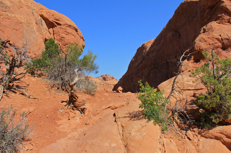
 The skeleton of a Utah Juniper stands guard over the vista of the Colorado River on the Rabbit's Ear Trail
The Rabbit's Ear Trail near Fruita, CO and the Utah border is a semi-desert hike to a river vista that will make you drop your jaw and find a rock and gaze stupefied into the distance. Not as easy as it looks, the route travels up and down humps of a ridge until it reaches a plateau 700 ft above the trailhead. From this point on, the trail is flat and the going is soft and easy.
 The trailhead with its kiosk
 An early trail segment with a smooth path and Sagebrush in the distance
Rabbit's Ear is part of the Rabbit Valley Recreation Area located at exit 2 on I-70 near the Utah border. While the main trails of Rabbit Valley can be filled with ATVers, Rabbit's Ear, 4 miles back west up a dirt road, is for hikers only. We had the entire place to ourselves.
 Utah Juniper (Juniperus osteosperma) dots the landscape as clouds hang over the distant western plateaus.
 Looking west into Utah. That is I-70 in the distance.
The terrain is rocky with occasional Utah Junipers, tufts of grass,
Yellow Rabbitbrush, clumps of the unusual Mormon Tea, and since we did this hike in May, the occasional wildflower.
 Desert Paintbrush (Castilleja angustifolia variety dubia) likes hot, dry, sandy soils. It blooms in the desert in early spring. Don't confuse it with Indian Paintbrush (Castilleja miniata), which is found in more alpine settings.
 A glimpse of the long ridge ahead. Our destination is the lump on the far right.
The Rabbit's Ear Mesa, whose shape gives the area its name, overlooks the Colorado River as it winds its way through several canyon systems. The sedimentary striations of long lost sand dunes are clearly visible from the trails many vista points. To the east the Book Cliffs and Grand Mesa can be seen in the haze.
 Ginger enters the slot canyon at 1.0 miles
 The trail traverses both rock and dirt as it climbs steadily higher.
I found myself stopping frequently on this trail. Not only were there numerous critters, plants, and vistas to photograph, but this was the first hike of the season after being laid up all winter with a foot injury and I was sucking wind more than I would like to admit.
 Another trail segment heading up through Utah Juniper
 A steeper segment
Some mileage points to guide your journey include a small slot canyon at 1 mile, the final stretch to the top of the mesa at 1.36 miles, and 2.3 miles to the best views. The trail does continue around in wide circle past our stopping point but we were doing this in the heat of the day and decided not to take the longer route back (6 miles round trip versus 5 miles round trip). As it was this trail was rougher than I should have been doing first time out of the gate.
 Looking down on the Colorado River and colorful rocks of ancient sand dunes
 There were several specimens of the Claret Cup Cactus (Echinocereus uspenskii) blooming along the trail. It typically grows in clumps in rocky open areas between 4,000 and 9,000 ft.
At our stopping point, one is gazing down into Ruby Canyon, which has resulted in this trail to be called the Ruby Canyon Overlook in several prominent hiking guides. In the distance is the Black Ridge Canyons Wilderness Area and the entrance to Mee Canyon. Further away are Utah's Le Sal Mountains with their snowy peaks and the broad expanse of the Uncompahgre Plateau, which we planned to drive around the following day.
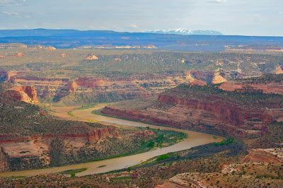 The view to die for. The Colorado River as it winds through Ruby Canyon on the way to Utah. Tiny rafts dot the river. The snowy peaks of the La Sal Mountains in Utah are visible in the distance.
 Heading back down at the edge of the mesa
We could see several large rafts floating serenely down the river. I couldn't help but wonder what the canyon looked like from that level. Certainly, the towering walls must have been majestic indeed.
 A photo of rocks, lichens, and a rail tunnel in the distance
 A close up of what looks like the Red Crust Lichen (Caloplaca trachyphylla). Lichens are actually two organisms. A fungi and an algae living together in a symbiotic relationship. The algae provides food and the fungi provides the home. They are common throughout Colorado. The Egg Yolk Lichen is another favorite.
 There are two common lizards on the western slope that can be hard to tell apart. The Plateau Lizard (Sceloporus undulatus) and the Sagebrush Lizard (Sceloporus graciosus). If I had to guess, I would say the former. These lizards feed on insects, primarily grasshoppers, moths, crickets etc.
If you are in the Grand Junction Area and are looking for a short hike with major payoffs, this hike if for you. Just bring plenty of water and be prepared for changing weather conditions. This is snake country as well, so look before you sit or place your hands on any rocks. We did not see any snakes, but the lizards were out in force, so I know the snakes were out there too.
 A close up of Mormon Tea (Ephedra nevadensis). This unusual plant has long, jointed needles. It is highly prized for various medicinal properties.
 A parting shot of the river and desert beyond