Showing posts with label oregon. Show all posts

Saturday, February 9, 2013

Oregon: Redwood Nature Trail

Distance: 1.1 mile loop
Elevation Gain: 290 ft
Date Hiked: 22 May 2012
Bathroom at Trailhead: Yes

Coastal Redwoods are the star of the Redwood Nature Trail
No journey to the southern Oregon coast is complete without a stroll through a swampy Redwood Forest. The Redwood Nature Trail, in the Siskayo National Forest near Brookings Oregon, loops through the northernmost Coastal Redwood grove in the U.S. and is a great day trip for those touring the area.

Map of the loop
No surface is without its cover of greenery
Coastal Redwoods are the tallest living thing on earth. Heights over 300 ft ... can you say 27 stories... and 20 ft in diameter are not uncommon. This grove is old growth which means that some of the trees are over 2,000 years old. Fie to you Europeans who say the U.S. has no ancient monuments!

The lower riparian environment is overflowing with shrubs
Entering the zone of Redwoods. Note the Sword Ferns along the trail.
The temperate rain forest that is a haven for these trees also promotes the growth of other plants.  Moss drips from every branch like a drag queens gone wild with green feathered boas. Tanoaks, Douglas Firs, and Bigleaf  Maples compete with the Redwoods for sunlight. Meanwhile Ferns, Rhododendrons, and Huckleberry's fight and unseen battle for the choices spots in the undercarriage.

The grove gets thicker
And taller...
A journey on the Redwood Nature Trail is like walking in a giant terrarium. I kept expecting giant lizards to come slithering through on their way to their food bowl. The route starts out in a mixed hardwood forest, crosses a stream and then steadily heads upwards. It is the upper part of the loop, in a more drained environments that the king of trees reigns. You won't have any trouble identifying these titans, the ache in your neck will give them away.

It was hard not to linger and wonder at these trees.
Leaving the grove and heading back to the car.  Lady Ferns dominated this trail segment.
We took our time and lingered in the upper reaches of the loop before heading back downhill to the parking lot. There are markers every so often that match the brochure we picked up at the trailhead so you can learn about the teeming diversity all around you if so inclined.

Crossing the creek again just before the trailhead
We did this trail after hiking the Riverview Trail in Loeb State Park. The two connect for a 3 mile round trip excursion. You get to Loeb State Park and the Redwood Nature Trail just beyond by driving 10 miles up County Road 784 out of Brookings Oregon. There is a parking lot and bathroom on the left. 

Thursday, May 27, 2010

Oregon: Columbia River Gorge

View of the Columbia River Gorge from the Portland Woman's Forum Scenic Viewpoint. Vista house is on the cliff to the right.

The Columbia River Gorge is a pastoral beauty that changes gradually with the seasons. It has sweeping vistas, a plethora of waterfalls, and giant slugs. What is not to like? While I-80 now zips through the gorge, to really see it, you need to take the history highway that starts in Troutdale and which winds lazily through the countryside. This was a great route to take my parents on. Most of the sites are easily accessible a short walk from the car. Below are a series of pictures from the trip.

Looking towards Portland from the Vista House

Looking down the gorge from the Vista House

A close up of the vista house and the mountains beyond

Could this be a brown specimen of the nefarious Banana Slug?


Latourell Falls


Common Camas (Camassia quamash)


Wahkeena Falls


Multnomah Falls


Bonneville Dam and Hydroelectric Power Plant. The roar was something to behold

This Eastern Gray Squirrel (Sciurus carolinensis) was unafraid of our car and my camera.

Monday, May 10, 2010

Oregon: Silver Falls State Park

South Falls

Silver Falls State Park is a phenomenal destination only an hour northeast of Salem on highway 214. It is located in a temperate rain forest in the foothills of the Cascade Mountains. 100-year old moss, ferns, and raging waterfalls are just some of the sites one can expect in the park.

South Falls Close Ups


I was traveling with my parents so we visited the falls that could be seen from the road or on short walks an level terrain.

Winter Falls


North Falls

Taken with a telephoto lens from the North Falls view point on Hwy 214 going towards Silverton

On this trip I was continuously amazed with Oregon weather. In the several hours we were at the park, we were hailed on twice and between each deluge, we had warm sunny skies!

The rain forest

The trail heading down to the bottom of South Falls. Every inch is covered with something growing!


Flowers


Mosses


Friday, May 7, 2010

Oregon: Haystack Rock/Cannon Beach

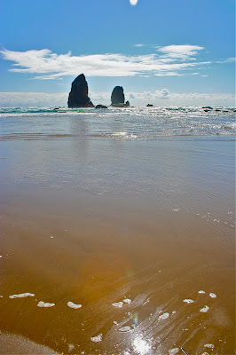
(On the left: Foam leads the way to Haystack Rock) Cannon Beach is located on the north section of Oregon's coastal highway. It rises 235 ft out of the sand and is a bird sanctuary this time of year for Gulls and Cormorants. To get there we drove highway 22 through Hebo until it connected with 101. Much of this route was through the lovely countryside and deciduous forests dripping with 100 year old mosses. Dare I say it was pouring rain the entire way!

We stopped at the Tillamook Cheese factory to go to the bathroom. That was a bad choice. The place looks like poorly done tourist trap.

The route does not reach the ocean until after the Tillamook Bay and Garibaldi. Like my recent trip to Nova Scotia, I was surprised by how little coast one can actually see on these drives. Trees and houses blocked the views whenever the ocean was near.

Sand and rock

Patterns in the sand in the rivulet near the entrance

Entrance to the beach

Looking south along the beach at one of the rivulets that bisects the beach

We swung through the town of Manzanita, which was cute and reasonable as far as real estate prices goes and had lunch in Cannon Beach proper. To get to the sands we drove back south and exited 101 onto a local drag. There were many places to access the beach.

The farthest south we got. The rivulet was deep in this spot

The same birds, but looking out to sea


The tide was out when we arrived and the rain held itself at bay. Wind coats and gloves were required but the sun was shining. We walked up and down the beach for a while but ran into several streams we could not cross without taking off our socks and shoes.

The rocks in their natural state

Playing with color

Standing next to the rock and looking south

North Rock Creek Snowshoe

Distance: 4 miles round trip Elevation: 9,180 ft to 9,780 ft Elevation Gain: 600 ft Dogs: Off leash until the wilderness boundary North...