Showing posts with label mesa trail. Show all posts

Saturday, January 7, 2012

South Boulder Creek West

Distance: 4.0 miles round trip
Elevation: 5,485 ft - 5,803 ft
Elevation Gain: 318 ft
Date Hiked:  11 December 2011
Dogs: Off leash in designated areas with Boulder green tag
Bathroom at trailhead: Yes
Tags: #Boulder, #osmp, #openspace, #hiking

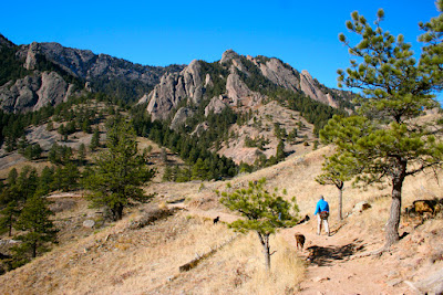
Big sky and open space greet the hiker on the South Boulder Creek West Trail
South Boulder Creek West Trail is an east/west trail that connects Highway 93 to the Mesa Trail south of Boulder.  It can be walked or ran in its own right or used as a means of connecting into the many trails of the South Mesa Trail system. 

Looking back at the trailhead after crossing through a grove of Cottonwood trees
Flatirons in the distance.  The trail will curve off to the left.

While I have seen this trail listed on a map of the area, I have never been sufficiently motivated to check it out, preferring to start out on the Mesa Trail itself from the South Mesa Trailhead.   A friend convinced me to go, however and I was pleasantly surprised by the experience.   The views of the flatirons are quite expansive from this trail and the broad open fields, lightly covered in snow, were welcoming as only wide open spaces can be. 

Trees dot the landscape
Twisted Cottonwood

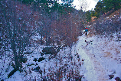
We did this hike late on a Sunday afternoon in the middle of December.  At that time of year, the sun sets behind the flatirons around 3:30pm, so we did not have much light to play with. The trail is easy going, particularly when covered with snow, however so we were able to make good time.  It is almost a mile before the trail starts of narrow and become more rocky. 

A more narrow, rocky trail segment
Clouds in the sky, snow on the ground.  Can you tell the difference?
There is not much to tell about this trail other than it winds over hill and dale, passes through occasional groves of Cottonwoods or Ponderosa Pine, but is otherwise in the open.  This exposure felt great on a cold, but sunny day in winter but would feel like Hell's Half Acre in August.  The scaly ones would be out then too,  looking to snag an ankle snack. 

We got back to the trailhead just in time.  The sun had set and the temperatures dropped 20 degrees.
For other posts of trails in this area, check out my description of the Homestead/Mesa Loop.  The pictures for this post were taken with a cell phone camera.  Amazing eh?


Saturday, December 31, 2011

NCAR/Mesa Trail to Kohler Mesa

Distance: 5 miles round trip
Elevation: 5,120ft - 6,250ft
Elevation Gain: 1,237 ft (cumulative)
Dogs: Off leash in designated area with Boulder green tag
Bathroom at trailhead:  Inside NCAR
Tags: #OSMP, #boulder, #hiking, #coloradooutdoors

A hike from NCAR to the Mesa Trail and beyond takes you along the scenic Flatirons.
Nestled next to the Flatirons in Boulder, CO is warren of trails that can be combined in all sort of ways. This post describes a out and back that starts at NCAR, the big pink castle on the hill, and travels the Mesa Trail south down to Kohler Mesa. Most of the trails along this route are owned by Boulder but part of them belong NOAA. For those who want to bring their dogs, leash restrictions vary and you'll be putting your dog on and off leash.

Map of the route. The red circle is the water tank. The red square is the picnic table at the end of the route.
The first 0.2 miles of trail is an interpretive trail behind NCAR. 
The towering 3rd Flatiron from the trail behind NCAR. 
Any outing in Boulder that starts from NCAR has one major advantage. You'll never run out of parking! As Boulder continues to grow, parking at various trailheads continues to be a problem. Most fill up by 8am and have a parking fee for non-residents to boot! NCAR has hundreds of parking spots, and while the ones closest to the trailhead will be full, you can always find a spot.

Heading down the south side of the mesa NCAR sits on
Turn right at this junction and it will connect to the Mesa Trail going north
The route begins on the north side of NCAR and follows an interpretive trail for 0.2 miles before heading down the south side of the hill. The trail then travels down and around and then up the steep slope of a hogback to a large green water tank. The Mesa Trail is located on the backside of the hogback, down another series of trails with million dollar views of the Flatirons.

On the Mesa Trail heading south
Snow and Ice can collect in this gully in winter
On the west side of NCAR, the Mesa Trail weaves up and down to the junction of the Kohler Mesa Trail at 1.4 miles. It is a short 1 mile across Kohler Mesa to the NOAA trailers and a picnic table on the right. From this vantage you are gazing across the plains. The NOAA complex is just below with the University of Colorado nearby.

Heading up the north side of the gully
Further along the Mesa Trail
For the return, you can retrace your sets or descend off of Kohler Mesa to the Skunk Canyon Trail (see map), which parallels Kohler Mesa at the bottom of Skunk Canyon. Head west on this trail and it will eventually climb back up to the Mesa Trail.

Ponderosa Country
On the eastern end of Kohler Mesa. The gate ahead marks the boundary with NOAA property.
Trailers on NOAA's property

Sunday, December 21, 2008

Homestead/Mesa Loop…Don’t forget the history

Distance: 4 miles round trip
Elevation: 5,645ft – 6,300ft
Elevation Gain: 655ft
Date Hiked: 12/13/08
Dogs: Off leash in designated areas with Boulder green tag
Bathroom at Trailhead: Yes

The Dowdy-DeBacker-Dunn Homestead gives the Homestead trail its name.  Frozen in place, its cold stones hold the memory of many Front Range winters. 
With yet another storm raging in the high country we once again set our sights on a lower hike along the Front Range. This loop near Boulder travels up the Homestead Trail for 1.1 miles, heads west along the Towhee Trail for 0.4 miles, then jogs 0.3 miles on Shadow Canyon before finishing up with 2.0 miles along the Mesa Trail.  There is a web of trails at the southern end of the Mesa Trail, and hikers can choose many different options.

Map of the route 
The beginning of the trail.  The homestead is just out of the picture to the left.
Heading up the Homestead Trail
The Homestead Trail is nice because it is a steeper and more strenuous ascent. It will get your heart rate going as you climb the many steps leading up to a broad plateau. From the top, there are views of the distant plains as well as the ever-approaching Flatirons.

View from the Homestead Plateau
Snow on the back side of the Homestead Trail
The Towee Trail is in a gully and the snow here was packed and slick

The Homestead trail descends back down the north side of the plateau to intersect with the Towhee Trail, which comes up the gully from the right. This (north) side of the plateau was still snow encrusted and very slick. The Towhee Trail also has the disadvantage of being a leash only, which is another good reason to start out on the Homestead Trail if you have dogs that need to run free.

Near the intersection of the Towhee and Shadow Canyon Trails
View from the Shadow Canyon Trail
Heading up the Mesa Trail
From the Towhee Trail, the loop heads east on Shadow Canyon for just 0.4 miles. There are nice views of some rock formations near this intersection and nice views of the plains a few yards up the trail. The Mesa Trail stretches 6 miles south to north, and at the intersection of Shadow Canyon and the Mesa Trail the hiker has the choice of heading north for another 4 miles or heading south directly. We decided to head north and upwards but were turned around by very slick conditions within a quarter of a mile. Just past the ruins of an old cabin, we turned around and headed back to the trailhead. The southern portion of the Mesa Trail is a broad. It winds gracefully downwards with sweeping views of the plains. The willows along the trail are filled with birds in the spring and summer.

Heading back down the Mesa Trail as it curves southward
Around half way back
Looking across to the Dowdy Plateau.  
At the apex of the Homestead and Mesa Trails are the remains of the Dowdy-DeBacker-Dunn Homestead. Built in 1858, all that remains is the stone section, unique for its multi-sized slab construction. In its day, an irrigation canal ran through it, providing fresh running water…of a sort. It seems hard to imagine this popular trailhead as the deep frontier but long before Boulder was founded, hearty stock had been settling in what was then Arapaho Indian country. For some it was gold but for others if was land for both farming and ranching. The original settler, Dowdy, ran a gristmill.

Close up of the rock construction
Crossing the stream at the trailhead.  Even in winter it has a stark beauty. 
 Colorado is filled with history and many of its trails are strewn with mining relics, the ruins of old cabins, and the ghosts of pioneers. Half the time we overlook these doorways into the past. Glued to our iPods and focused on cardiovascular performance, they simply fade from view. So, next time you hit the southern Mesa Trailhead, take a moment to examine what is left of the homestead and look around. Imagine living there over 100 years ago.

North Rock Creek Snowshoe

Distance: 4 miles round trip Elevation: 9,180 ft to 9,780 ft Elevation Gain: 600 ft Dogs: Off leash until the wilderness boundary North...