Distance: 7.6 mile loop
Elevation: 5,146 ft at trailhead
Elevation Gain: 1,247 ft cumulative by Dark Angel, 2,194 ft by return
Date Hiked: 26 April 2012
Bathroom at Trailhead: Yes
Water at Trailhead: Yes
Dogs: Not allowed, National Park
 |
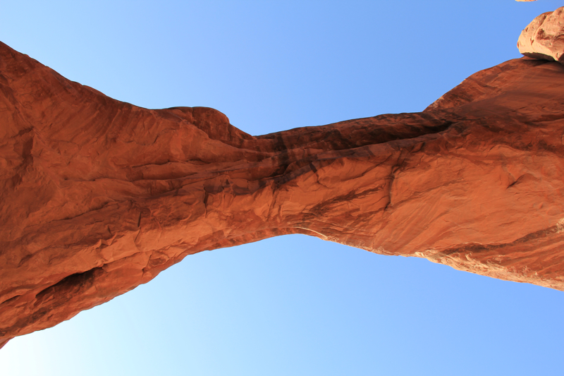
| Double-O Arch |
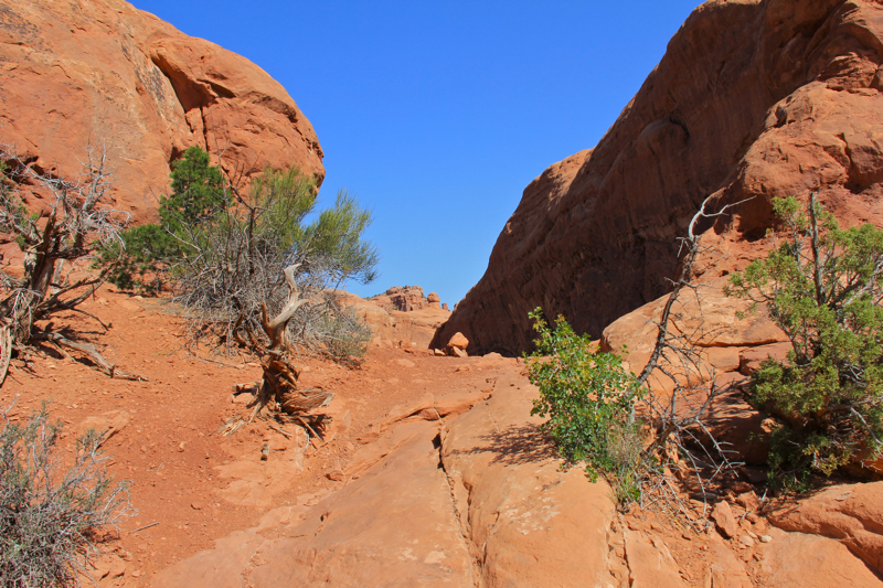
The Devil's Garden area of Arches National Park contains the landmark Landscape Arch, Double-O Arch, and Dark Angel. You can do this trail as an out and back or make it a loop by taking the Primitive Trail either before (at Landscape Arch) or after (at Double-O Arch). When I talked to the ranger at the visitor's center, he suggested taking the Primitive Trail first because it gets you away from people right away and you go UP the rock scrambles (e.g. slickrock fins) and not DOWN them. I decided to take his advice, which had both pros and cons. The pro was a serene journey through a secluded
Sagebrush and red sand prairie early in the morning when the birds were so vocal it made my ears hurt. There was so much evidence of other animal life that I felt like I was walking Bourbon Street the day after Mardi Gra. You could not see the people (or critters in this case) but you sure knew they had been there. The downside of this choice was that climbing slickrock faces with a heavy pack proved to be severely unnerving. While not as psychologically damaging as
Devil's Causeway in Colorado, it still made me wonder what I had gotten myself into. Bottom line is that I am not sure I agree that going UP is easier. Taking the Primitive Trail last (at Double-O Arch) is certainly the advertised way of doing it.
The first 0.8 miles of the Devil's Garden Trail is manicured and accessible to casual hikers. At 0.3 miles is the junction with the Pine Tree and Tunnel Arch trails. These short spurs lead to two attractive arches. I particularly liked Pine Tree Arch because of the large
Utah Junipers that graced the middle of it adding both a sense of scale and floral contrast. Take this side trip and you will return to the junction at 0.8 miles.
 |
| Trailhead |
 |
| The first part of the trail squeezes through two fins |
 |
| Heading out into the prairie |
It is a short distance to Landscape Arch, one of the iconic arches in the park. At 290.1 ft, it is one of the longest arches in the country and also one of the thinnest. Arches have lifespans (in geologic time of course) since they are caused by weathering, which never ends. Landscape Arch is considered a mature arch, which means it gave up beer binges a few thousand years ago and now is interested in conservative politics and medicare supplement plans. It sure looks like it could collapse at any moment. Before you get to the Landscape Arch viewing area, the Primitive Trail (at 1.35 miles) leads off to the right. I took this trail and immediately left the manicured trail for red desert sand.
 |
| Tunnel Arch |
 |
| Pine Tree Arch |
 |
| Approaching Landscape Arch |
The ranger was right. I left the people behind immediately and for the next hour at least did not see a soul. The birds were rather chatty, flitting from shrub to shrub and calling to each other in raucous tones. I had put ice cubes in my Nalgeen bottles and was annoyed that the racket that the ice made was drowning out the birds. Fortunately, there were so many fascinating animal tracks in the sand that I frequently had to stop and admire them. That let me capture a few birds on "film" as well as a Gopher Snake, which had me enraptured for several minutes. The
Sagebrush, Mormon Tea, and
Utah Junipers dominated the landscape and smelled fresh and alive in the early morning air. I was in love with the solitude and in love with Arches at this point. Around 2.2 miles in, however the trail left the prairie and descended down into a dry wash similar to but more narrow than the
Park Ave Trail. The trail followed this wash up into a long formation of fins. I was quite confounded when the trail deadened into a crenelation of this formation until I realized I need to climb UP and OVER the fin.
 |
| Looking back down the trail towards the La Sal Mountains |
 |
| Just a small sample of the tracks that appeared on the trail |
 |
| I came across this Gopher Snake (Pituophis catenifer deserticola) crossing the trail. It may be a male since they are active in the spring looking for mates. Fortunately, he was not interested in me. |
While not too dangerous, the fin (at 2.6 miles) was probably only 30 feet in height, it was slick being made out of slickrock after all. There were no hand or foot holds and after trying to leap up the first five feet I realized a new strategy was required. I took off my heavy pack, which was pulling me backwards, and shoved it upwards. I then turned around and bootie scooted upwards using the souls of my shoes to provide the leverage. This got me up the first pitch. The rest of the route was a eerily sloping rock face with nothing to grab on to. I kept my pack off and held it in one hand so I could lean into the rock face with the other. It was of course on this perilous maneuver that I ran into my first human.
 |
| Fins along the trail |
 |
| Interesting rocks |
 |
| The Black-throated Sparrow (Amphispiza bilineata) was one of the many birds in the area. |
The nimble youngster (in geologic terms of course) that came bounding down the the cliff face at me was overly nice. He mentioned this was the worst part of the trail, what a lovely day it was, and clearly thought that it was great that modern nursing homes were allowing their residents to go climbing fins all alone. I growled in annoyance as he whisked past and was about to lurch forward in one last suicidal push when I ran into my second human. What was the luck? Here I was out in the middle of NOWHERE trying to pretend that I was a buff hiker and I had the local paparazzi watching me flail up the scariest part of the route. This second human was less than patient with me even though it took me only two cardiac arrests to throw up self upwards past him. He blundered past and I collapsed at the top under the thin pretext of taking a picture of a interesting plant.
 |
| Heading down into the wash |
 |
| This is the nefarious fin. The rock cairn is the only clue you need to climb over it. It looks easier than it really is. The rock is sloped and you have to take it at an angle. |
 |
| After the fin the trail heads back into the brush. |
After this point the route traversed a few more fins with only one more slightly onerous pitch up another sloping but not precipitous chunk of rock. Ok, so was it really my pack that was pulling me backwards on these auditions for Cirque du Soleil or was it my middle-aged buttocks, which lost all pretensions to "buns of steel" about twenty years ago. To be fair, my pack was heavy, being loaded with lots of extra water (very heavy), a VW-bus sized first-aid kit with very sharp knife (a la "127-hours"), tons of layers, and one very large camera.
 |
| Private Arch |
 |
| Desert Paintbrush (Castilleja chromosa) |
 |
| After Private Arch, the trail heads back out into the Prairie. |
After the fins, the trail returned to a series of intra-fin interludes that included a short side trip to Primitive Arch (junction at 3.2 miles, arch at 3.5 miles). It was there that I ran into a couple from North Carolina that were taking the Primitive Trail in the same direction that I was. Were you scared back there they asked me with eyes as big as pizzas.
 |
| Heading out towards Dark Angel |
 |
| Dark Angel |
 |
| Returning to Double-O Arch |
After Primitive Arch, the trail begins to leave the fins and return to more
Sagebrush Prairie. I came upon the Double-O Arch rather unexpectedly (at 4.2 miles). The trail to Dark Angel, a tall spire of rock, begins at the Arch, you will see it off to your right. Head that way first and you will reach Dark Angel at 4.7 miles. Then retrace your steps to Double-O Arch.
 |
| After Double-O Arch you have to climb over another fin and head upwards. This was actually difficult to find. |
 |
| A shot of the narrow fin between Double-O Arch and Landscape Arch. There is a lot of exposure on this section with the fin becoming narrow and fatter in turn. When I crossed, the wind was practically picking me off my feet, which made it less fun. |
 |
| View from the fin |
After the trip to Dark Angel, there were several of us trying to find the main trail around Double-O Arch. It turns out you have to climb over another fin and follow it upwards to get to the trailhead. It is really only a mile back to Landscape Arch, but it seems longer. There is a long "stroll" across the top of a very exposed fin that reminded me too much of
Devil's Causeway. I happened to cross at the peak of a thunderstorm when the winds were practically lifting me off my feet. I stopped a few times on the wider areas to crouch down until the gusts died down. Others hikers coming towards me were less intimidated but they did not have packs on to catch the wind.
 |
| After the fin there is a sign pointing to the trailhead. |
 |
| Landscape Arch is just below. This section was not obvious despite the cairns. |
 |
| Coming down this fin it was not obvious how to get down. Turns out there is a series of switchbacks that make it easy. |
After this section the trail follows more slickrock until it descends sharply between two upright fins. Had there not been people coming up from below I might have thought I had taken a wrong turn. The descent is very steep and you can not see the bottom of the fin while on it. I was concerned about getting cliffed out so I was approaching this pitch cautiously. It turns out that in the pitch hidden from view there are a couple of switch backs in the rock that make the decent rather easy. After this spot it is only a 100 yards or so to Landscape Arch (at 6.7 miles). I returned to the trailhead for a 7.6 miles total distance. Somehow I missed the turn off to Navajo and Partition Arches, which is why my calculated mileage is slightly less than others.
 |
| Returning to Landscape Arch |
 |
| Returning to the trailhead provides a final view of the La Sal Mountains. |
Arches is not known for long hikes, so if you really like to be out all day, the Devil's Garden/Primitive Loop will fill the bill. Its early solitude and exposure to the plants and animals of the area will please the naturalist in all of us.