Showing posts with label Lyons. Show all posts

Saturday, June 8, 2013

Antelope Park (Button Rock...Hall Ranch) Loop

Distance: 7 mile loop
Elevation: 5,972 ft - 6,731 ft
Elevation Gain: 1,600 ft cumulative
Date Hiked: 14 April 2013
Bathroom at Trailhead: Yes but up the trail a bit
Dogs: On leash until Sleep Lion Trail

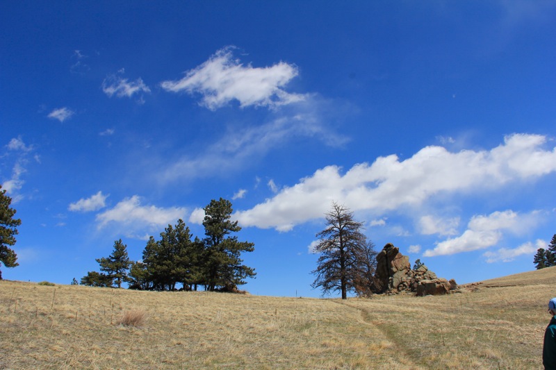
Rock formations and open meadows dominate Antelope Park.
Antelope Park is a long sloping meadow nestled between the Button Rock Preserve and Hall Ranch in Lyons Colorado. At the far eastern end is a large pile of rocks that make for an interesting destination. This loop hike is not on any maps, but is easy to navigate on the ground and will transport you back in time to the age of the Colorado pioneers who lived and worked ranches in the hidden valleys between Lyon's and Estes Park. 

The trailhead parking lot
The first 0.9 miles follows this private road. 
Because this trail is so little used, there are few places where the trail itself fades into the grasses, but most people should be able to navigate these sections with minimal angst.

The turn off for the Sleep Lion Trail
The turn off for Antelope Parks is the small spur trail to the left.  The  loop will end up returning to this  point down the main trail. 
The route to and from the rocks traverses several different Front Range biomes including a Ponderosa Forest, open grasslands, riparian (think frogs) lowlands, and rocky traverses. While it may become "hells half acre" in the heat, in spring and fall it is delightful and in the "lusty month of May" you might just see a fairy or two.

The initial part of the loop goes steadily upwards through Ponderosa Pine and rocks. 
This loop starts and ends at the parking lot for the Sleepy Lion Trail in Lyon's Button Rock Preserve. On the west side of the lot is a gate that allows residents of the area access to a broad flat road that heads east towards the Ralph Price Reservoir.  0.9 miles up the road is the turn off for the Sleepy Lion Trail, which is well marked by a sign. While the main route for Sleepy Lion continues straight up the hillside, the route to Antelope Park splits off only 0.1 miles up the Sleepy Lion Trail across from a green and white sign. This split look like a social trail and decsends down into a ditch but quickly ascends up the other side.

The segment where the trail fades.  
The initial part of the route weaves upwards through a long series of switchbacks that also take the hiker back in the general direction of the parking lot. You will realize this when you end up at a view point looking back down the road. At 1.3 miles is an unmarked trail junction. Stay right. At 1.5 miles is a small social trail to a pile of rocks. Stay right here as well.

A segment in the trees
The route then skirts to the west of two oval hills, which can be clearly seen on the topo map. These hills form the northern boundary of Antelope Park and the route stays close to the hills as it heads steadily upwards and eastwards towards pile of rocks. There are several places along this side of the meadow with views of bucolic downs suitable for garlanded maidens in diaphanous dresses or for the less imaginative, the occasional cow. At 2.4 miles you will go through a fence used by ranchers in days gone by.

Entering the wide meadow of Antelope Park
Approaching the rocks
At 2.8 miles and 6,715 ft the rocks that mark the apex of the loop appear just below the crest of the meadow slope.  They stand starkly puritan over the fairy tale frolics of Thumper, Maid Marion, and Tinkerbell whom I could sense tittering on the wind just waiting for us to leave. Around the rocks are several other trails. The Button Rock Trail, which will be part of our loop, heads back down the middle of the meadow. Someone cut down a large oak tree recently and chunks of log make for a suitable spot to lounge. 

Leaving the rocks and heading down the center of Antelope Park
Further down the meadow
Since it was not quite spring when we did this hike and a bracing breeze was blowing down from the mountains we did not linger long at the rocks but headed back down the meadow at a steady clip. The views in the meadow are even better than those from the side. The two oval hills are obvious to the north, and the trails winds in and out of meadow and forest as it heads steadily downwards. Don't assume the fairies are leading you astray when the trail switches from single track to road to single track again. Just follow the signs. The first one will appear at 3.0 miles.

The trail leaves the road and transitions back into the forest at this sign.
Standing on the Sleep Lion Trail looking back on the route towards the Button Rock Trail (sign in the distance). 
The final section of route at 4.9 miles is on the Sleep Lion Trail as it travels around rock formations, more meadows, and more Ponderosa Forest. By the time you reach the road at 5.9 miles, you'll be glad to stride out for a mile back to the car.

On an open segment of the Sleep Lion Trail
If you like the hikes around Lyons (Lion Gulch, Sleepy Lion, Rabbit Mountain, and Hall Ranch), you'll enjoy this hike as well. Just say hi to the fairies for me.

Monday, May 18, 2009

Bitterbrush Trail (Hall Ranch)

Distance: 5.5 miles round trip out of a possible 7.4 miles
Elevation: 5,499 ft to 6,179 ft
Elevation Gain: 680 ft

The mesas of Hall Ranch Open Space

I used to hike Bitterbrush a lot when I lived closer to Lyons. It has an “old west” feel to it because of the large eroded bluffs near the trailhead. It also climbs over a large formation of igneous rock, which I found particularly appealing.

The beginning of the Bitterbrush trail

On this trip however, I felt like I was trying to hike on the Los Angles freeway, there were so many mountain bikers lunging down the trail or struggling up it. It really was a distraction. I know it was a very nice day and bikers have a right to exist too, but geesh, you would think they could at least have some manners. Half the time we were not aware of the bikers until they were practically on top of us. At one point I had to leap off the trail and into a large prickly tree trunk to escape total annihilation. The bikers must have recently “discovered” this trail because in all my time hiking it, I had never seen this many.

Igneous rock in the switchback section. This area is flat, much of the area was not.

Blooming cactus on the trail

Bitterbrush is a low elevation hike, which make it suitable for the spring and fall. Right now with all the hills green, it is particularly attractive. I was amazed too how much wildlife we saw. There was tons of Mule Deer, Cottontail Rabbits, Prairie dogs, and even a juvenile Golden Eagle.


Looking west from a view point on the switchback portion
Above the switchbacks, the trail becomes a wider road through open meadows

The trail starts out near a very nice picnic facility. I have always wanted to have a group BBQ there because of the large protected tables. After a half-mile traverse of the open meadows the trail ascends a large series of switchbacks. These switchbacks are imbedded into a large igneous rock formation. At times there are nice plateaus and at other times deep ankle twisting cuts. Throughout, Ponderosa Pines scatter the hillside. There were only a few wildflowers out but you could tell more were on the way.

Vista near the intersection of the Antelope Trail

At the top of the hill, the trees fade and the trail, now much wider, skirts a hillside with expansive views to the west and north. At 2.25 miles is the junction of the Antelope Trail. Continuing drops the hiker 100 feet or so down into a meadow. This is home to the highest Prairie dog colony in Boulder County.

Deer in the meadow

We decided to head down for another half mile and ended up turning around at one of the Prairie dog interpretive signs.

Looking north from the highest point. The Antelope Trail is off to the right through the trees. There is a bench along the trail in the lower left portion of the picture.

Because it is so open, Bitterbrush makes a great winter hike. Unless we have a major dumper, there is usually little snow.

Down in the meadow heading northwest

Please note, that this is a non-doggie trail, which is another reason I have not hiked it much lately. It may also be the reason that so much wildlife was present.

Even more deer on the return back through the switchbacks. I would have thought the continual stream of bikers would have disturbed them, but they seemed non-pulsed.

Sunday, November 23, 2008

Button Rock Preserve/Sleepy Lion Trail

Distance: 6 miles round trip
Elevation: 5,960 – 6,420 ft
Elevation Gain: 460 ft


Ralph Pierce Reservoir viewed from the Sleepy Lion Trail. You can see Mt. Meeker in the distance.

Button Rock is a delightful and lesser-known open space just west of Lyons. It is dog friendly, contains views of distant Twin Sisters, and skirts a narrow reservoir bordered by pine trees. It is another of my favorite shoulder season hikes.


Creek along the initial part of the trail to the dam

The trail starts off in a large dirt parking area surrounded by high cliffs. On the west side of a wide gate, a broad flat road heads east towards the Ralph Price Reservoir. The road transects the canyon with several interesting water features along the way. If you continue heading west, you will end up at the base of the dam, but for a more interesting route, take the Sleep Lion Trail around a half-mile up the road. A large sign marks the trail.


These man-made falls are about half-way to the Sleepy Lion turn off.


Rocks along the Sleepy Lion Trail

The Sleepy Lion Trail winds through Ponderosa and Douglas fir. There are occasional open meadows and isolated red boulder formations. At the high point you can see the tip of Mt. Meeker and the double hump of Twin Sisters. There are also views of the reservoir itself.


Twin Sisters in the distance

From the highest vantage, the trail descends down an old rail bed to the base of the dam. Here a dramatic jet of water shoots out of the reservoir’s water control feature. It is difficult to pull oneself away from the chaotic and powerful display of man’s attempt to control nature.


The Ralph Pierce Reservoir seen from the Sleepy Lion Trail

On the far right-hand side of the dam is a short but steep trail up to the reservoir itself. This ascends several hundred feet through several highly eroded areas. Anyone used to Colorado’s steep ascents will find this short jaunt to be trivial. For those who wish an outing that is easier on the knees, skip the trail and head back down the broad road to the trailhead.


The old rail bed portion of the Sleepy Lion Trail

The Ralph Price Reservoir is an interesting and rarely visited place. There is no official trail that circumnavigates it, but you can walk along the right shoreline for a mile or so. In low years, there are boulders to nestle in and in high years, the deep blue waters of the reservoir lap the shoreline almost to the level of the trail. If the wind is not blowing too much, this is a pleasant place for a picnic.


Water jet


Base of the Button Rock Dam

To return to the trailhead, the hiker has two options, he can return down to the base of the dam via the steep trail or wander up and around to one of the dirt roads that skirt the area.


The deep blue of the Ralph Pierce Reservoir

On a sunny fall day, Button Rock can be a pleasant Front Range excursion. While known to the locals, it is rarely visited by those outside of Lyons. This does not mean that it will be uncrowded, however, but I have found that most visitors stay on the main road and do not take the more scenic but more strenuous Sleep Lion Trail.

North Rock Creek Snowshoe

Distance: 4 miles round trip Elevation: 9,180 ft to 9,780 ft Elevation Gain: 600 ft Dogs: Off leash until the wilderness boundary North...