Distance: 4 miles round trip (out of 6 miles possible)
Elevation: 10,000 ft - 10,306 ft
Elevation Gain: 695 ft (cumulative)
Bathroom at Trailhead: No
Dogs: Off leash
Date Hiked: 26 August 2013
 |
| West Lime Creek near Silverton Colorado |
West Lime Creek in the middle of a San Juan rainstorm is like journeying to the Pacific Northwest. It is wet, primeval, and filled with VW-sized mushrooms. Most of the route traverses the drainage half way up the slope so there are lovely views of the creek below. On this trip, heavy clouds obscured the peaks in the distance but added to the otherworldly ambiance.
 |
| The "10,000 ft" sign indicating where to park. You won't see this driving from Silverton because of the angle and its location up the slope. |
 |
| Starting down into the drainage |
 |
| Initial trail segment |
The start of West Lime Creek is located at a sharp swtichback approximately 10 miles south of Silverton Colorado on Highway 550 at a small two-car sized pull off. Even though there is a small green sign with the word's "10,000 ft" that marks the spot, the sign is perched 20 feet above the road and easily missed. As it was there was a car in the middle of pull off with a "gentleman" peeing by the side of the road, all this anatomy exposed for world to see. We were so busy commenting on the bestial nature of some men that we raced by the spot not realizing we had passed the "trailhead".
 |
| One of several waterfalls along the route |
 |
| Crossing the creek |
 |
| This specimen of Rameria largentil, a yellow "coral" mushroom was found near the creek crossing. While some consider it edible, it is known for its powerful laxative effects. |
The trail descends 50 feet or so from the road and the levels out, traversing grass-covered hillsides or stands of Spruce and Fir. At 0.5 miles is small waterfall that can only be seen by grabbing onto trees and hanging percariously over the highly eroded bank. A few tenths of a mile further on, the trail crosses the stream above the waterfall. A large red arrow painted on a rock by the edge leads the way.
 |
| Crossing an open meadow |
 |
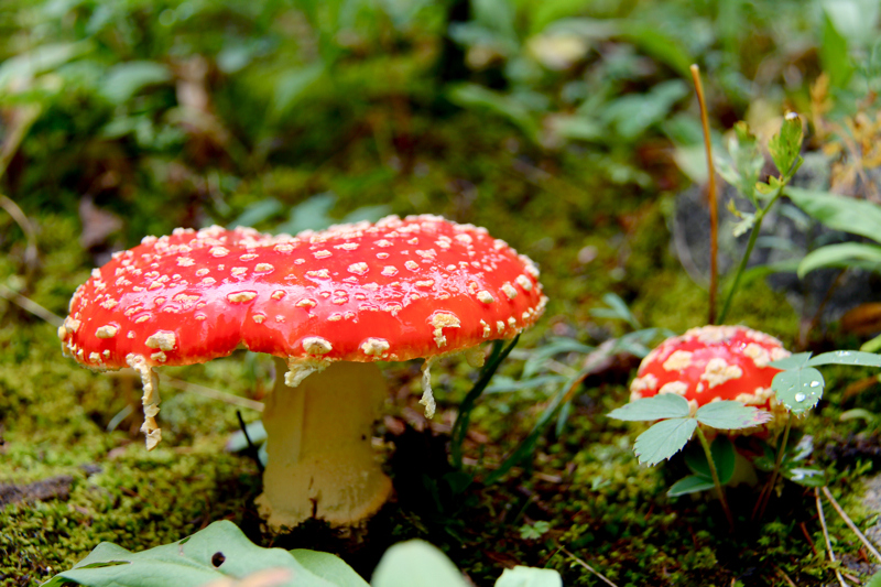
| I took another shot of this Amantia muscaria mushroom with my sunglasses perched easily on top. Witches brew anyone? |
 |
| This unnamed point at 12,200 ft is visible from several points along the trail. |
The San Juans are a wetter mountain range than others in the state and the flora proves it. We came across clumps of Coral Fungi, their bright yellow colonies standing out against all the greenery. Freakishly malevolent
Amanita muscaria toadstools covered the forest floor tempting the unwary to lick their poisoness slime. They are easy to identify with their bright red tops, white stems, and white dots. Pine needles covered the trail creating a soft and welcoming journey.
 |
| Much of the route in the forest was damp and dripping. No surprise given the weather, but the flora indicates it is wet much of the time. |
 |
| This is a close as you can get to this waterfall. |
 |
| Close up with a zoom lens |
We chose West Lime Creek as a way to get some exercise on an other wise very rainy day when hiking above treeline is otherwise not recommended. We wanted to try several smaller hikes and only went 2 miles up the drainage while 3 miles is possible. Right around 2 miles the trails starts to drift to the west opening up views of the Twin Sisters, two rounded 13ers that dominate the skyline.
 |
| As the trails curves to the west, the Twin Sisters, two 13,000 ft peaks come into view. The Colorado Trail travels along the ridge ahead, just about treeline. |
West Lime Creek is a fascinating trail that anyone visiting Silverton will want to put on their list. It can be done as a break between the harder and more famous Ice Lakes and Highland/Mary Lakes or as a worthwhile destination in its own right.


3 comments:
Yep - waterfalls and mushrooms - looks like the PNW.
hi ı am from Turkey. ı want to read your blog but ı cant see your archive. where is your archive. ı dont want to do Older Posts because ı read different time and dont lost any post.
Hi,
I don't have an archive per say. All my posts are linked on the left and right side by geographical area. Just pick one.
Post a Comment