Distance: 5 miles round trip, including overlooks
Elevation: 5,463 ft - 5,887 ft
Elevation Gain: 1,057 ft cumulative
Date Hiked: 21 April 2013
Bathroom at Trailhead: No but ones nearby
Dogs: Not allowed, National Park
 |
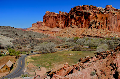
| The stunning views from the Cohab Canyon Trail, Capitol Reef National Park |
Capitol Reef National Park is one of the less frequented parks in Utah, which is a shame. Its towering rock walls, mind-blowing geology, and male, overly frisky, Wild Turkeys is an intoxicating combo. The Cohab Canyon Trail, which starts near the famous Gifford Homestead (think homemade PIES), is a great way to get above the central valley (Fruita) and look down on all the bucolic splendor of this desert oasis once inhabited by Mormon pioneers. Who out friskied whom, the Mormons or the Turkeys is alas, lost to the ages.
 |
| The trailhead |
 |
| An initial trail segment. Note the Basalt debris covering the trail. |
I chose the Cohab Canyon Trail from a guide book but when I stood below the sheer cliff that is the beginning of the route I started to sweat. The people higher up seemed to be throwing themselves upwards in gymnastic moves and the rocky outcroppings seemed impassable to mere mortals. My hiking companion reminded me however that this was a National Park, and sure enough the trail upwards was like Disneyland, perfectly groomed and easy to navigate. It was only 300 ft to the top of the cliff and I was actually bummed when we reached the top, it was too easy. Commence guilt trip.
 |
| View from part-way up the initial ascent |
 |
| After ascending the cliff, the trail follows an edge before plunging into the canyon. |
After the initial ascent up the cliff, with its stellar views, the trail heads down into a canyon that expands and contracts whimsically. Sometimes you are walking between ancient sand dunes and other times over more recent volcanic debris.
Utah Junipers dot the landscape while Side-blotched Lizards scurry from rock to rock. There are a few slick rock sections, but most of the trail is on soft sand.
 |
| Eroded ancient sand dunes |
 |
| A segment over slickrock |
There are two side trails leading to valley overlooks that are a must do and will provide just enough elevation gain to mitigate the aforementioned guilty conscious.
 |
| The Side-blotched Lizard (Uta stanburiana) is the most common in the park and boy can I believe it. They were everywhere. |
 |
| This eroded segment of sandstone looked like a Navajo painting. |
We had planned on taking the trail all the way down to the highway, crossing over and hiking the Hickman Bridge Trail for a longer outing. Unfortunately, the trail was closed due to a rock slide, so we decided not to descend all the way to the road just to turn back around and hike up again. Hmmm, maybe I was not feeling all that guilty after all.
 |
| View from the first overlook at 1.6 miles. Here the ancient dunes of Navajo Sandstone are clearly visible above the dramatic Wingate Sandstone. A few days in this area and you will be identifying rock layers too. |
 |
| Enroute to the second overlook |
If you visit Capitol Reef and are looking for a quick hike to get your feet sandy, this hike will please. While not a loop, it looked sufficiently different on the way back to count as a totally different route.
 |
| View from the second overlook at 1.9 miles |
 |
| Near the end of the trail |
A final logistical note...parking for the Cohab Trail is non-existent. You have to park in the nearby campground or in the Gifford's House parking lot. It is a hundred yard walk to the trailhead from either location.
 |
| Finally, here is one of the male Turkeys we ran across. This boy was strutting his stuff around three hens who were immune to his obvious charms. |


2 comments:
Stunning shots. Love all the red rock.
We just did this trail in May! LOVED the pies from the Gifford House...also had the $1.00 ice cream!!
Post a Comment