Distance: 6.5 mile loop
Elevation: 7,437 ft - 8,592 ft
Elevation Gain: 1,155 ft (net) 1,174 ft (cumulative)
Dogs: On leash only (Jefferson County Open Space)
Bathroom at the trailhead: Yes
Tags: #coloradooutdoors, #hiking, #jeffco, #
gearguide
Hikes nearby:
Three Sisters Southern Loop
 |
| A view of several ranches from the Three Sisters Evergreen Mountain Trail |
A hike to the top of Evergreen Mountain in the Three Sisters Open Space Park in Evergreen CO, is a great shoulder season training hike with some nice views at the top. The terrain traverses open Ponderosa Pine meadows as well as an overly thick Lodgepole Pine forest. Mountain bikers can can swarm as numerously and as annoyingly as mosquitos, but the curvaceousness of the route kept them moving slowly so it is easy to get out of their way.
 |
| Trail map showing the route. |
 |
| It is difficult to miss the trailhead. |
 |
| The lower part of the route travels through and open meadow dotted withe Ponderosa pines. |
This is a loop hike, that I took clockwise. Taken this way the trail starts on the opposite side of the road from the first Three Sister's parking lot (the one without the barn) on the East Evergreen Mountain Trail. The route heads south through a pleasant stand of open Ponderosa and Aspen trees, which on this trip was spotted with yellow
Golden Banner,
Wild Iris, and
purple Sugarbowls. After a short 0.32 miles is the junction with the Ranch View Trail.
 |
| Aspens on an early part of the trail. |
 |
| Heading across the broad hillside. There were a lot of birds in this area. |
After this junction, the Evergreen Mountain East trail continues to head south through small stands of Aspen before turning southwest and heading across a broad hillside. At the far end of this segment the trail reaches the slopes of Evergreen Mountain (at 0.84 miles) and starts a long series of switchbacks through a dense Lodgepole Pine forest. This is admittedly not my most favorite thing in Colorado. I find it monotonous and less fragrant than a Ponderosa forest and less exotic than the towering Spruce/Fir trees that prefer a wetter climate.
 |
| An example of one of the many switchbacks |
 |
| Approaching the junction of the Summit View and Evergreen Mountain West trails. Note the large sign and dense forest. |
The signage in this open space park are National Park quality, so it is impossible to get lost. The junction at 2.4 miles of the Summit Trail and the West Evergreen Mountain Trail is no exception. Take the Summit Trail to continue heading up the hillside. At 3 miles is the junction with a scenic view turn off, which is a short 0.14 miles down to a rocky shelf overlooking Evergreen. I ate my lunch here and had the place to myself.
 |
| The turnoff to the scenic view. |
 |
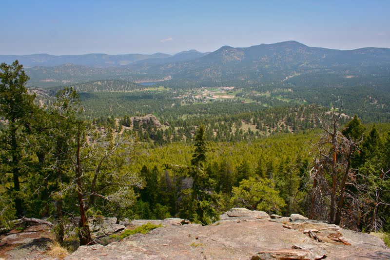
| The view of Evergreen, CO from the scenic overlook. |
I almost turned around at this point rather that complete the journey to the summit because I was confessedly over the Lodgepoles but I slogged onwards and I am glad I did. The final summit circle (junction at 3.28 miles) is more open and filled with Douglas Fir trees plus some large rocky mounds (at 3.58 miles) with pleasant views of the Mt. Evans Massif. There were a lot more people lounging at the top but with so many nooks and crannies, it was easy to find a private place to sunbath. By this point, I had climbed 1,092 ft.
 |
| One of the many rock pile son the summit. It is not as steep as it looks. |
 |
| The view of Mt. Evans from the summit. Notice all the ranch land. |
After heading back down, I came to the Evergreen Mountain West trail at 4.55 miles and took this trail to complete my loop. This trail has some nice granite boulders to break up the Lodgepoles. At 5.1 miles is a large sign explaining that this part of the hill is a Lodgepole demonstration forest where they have purposely tried to thin it back to normal. I was surprised to learn that unmanaged, this type of forest can contain as many as 5,000 trees per acre. No wonder it felt closed in to me.
 |
| A section of thinning forest. |
 |
| On the Evergreen Mountain West Trail. |
At 5.57 miles the route leaves the hill and transitions back to open meadows. Here is the junction with the Wild Iris Loop. Across the road is the second trailhead for the
southern side of Three Sisters. There are lots of great trails there as well. Back on the north side, this trail quickly becomes the Ranch View Trail, which will takes us back to the Evergreen Mountain East Trail (at 6.22 miles) that we started on.
 |
| Looking across the Wild Iris Loop, which circumnavigates the meadow, to the south side of the Three Sisters. |
This trail reminds me a lot of
Crosier Mountain near Rocky Mountain National Park. It's lower elevation means it will remain clear of snow most of the year, which makes it a useful training hike. Both hikes spend a lot of time in the Lodgepoles.
You get to Three Sisters by taking Hwy 73 just south of Evergreen Lake and then turning right onto Buffalo Park Road.


3 comments:
Wow, great post and beautiful photos! Looks like a really nice hike!
John
relaxedrush.blogspot.com
connectedtothevinephotography.blogspot.com
I enjoyed your journey. The area reminded me of when we went horsebackridging and the McGraw Ranch near Estes Park. It was not during tourist season so they sent us off on our own and said the horses knew their way back. As it was turning dark we were way up high with owls flying over our heads. Apparently the horses were taking the long way home...An exciting adventure!
Those are some of my favorite running trails in Jefferson County, and it's fun to see how someone else photographs the park. It looks very different because I tend to run after work.
The lodge pole pine photo (3rd from last) captures what I like about lodge pole forests: the almost surreal visual aspect of so many trunks all in line, contrasting with the flat forest floor below.
The bouldering is fun too; very relaxing to stand on the summit or sit on the boulders overlooking the foothills.
Nice work.
Post a Comment