Thursday, November 10, 2016

Chihuahua Lake

Distance: 8.5 miles round trip
Elevation: 10,460 ft - 12,282 ft
Elevation Gain: 1,822 ft
Dogs: Off leash
Bathroom at Trailhead: No
Tags: #coloradooutdoors, #hiking, #mountainlake
Nearby hikes: Lenawee, Argentine Pass

The deep blue waters of Chihuahua Lake
Chihuahua Lake near Keystone, CO in Summit County is a large glacial tarn nestled at the base of Grizzly Peak. The trail to the lake is not for soft paws however, being very rocky and filled with deep water crossings even in late summer. Additionally, the last pitch to the lake is a steep rock scramble requiring both agility and perseverance. The reward for those strong enough is a stunning view of the back side of Grays and Torreys and a pristine lake filled with deep indigo waters.

Heading up the lower portion of the jeep road
Passing a large boulder field
The first 2.7 miles of the trail follows Forest Service Road 263 and you will not be alone on this segment. I was quite surprised at the number of vehicles that passed us both coming and going because this is a road only for the hardiest of drivers. Because of this traffic, the road is very rocky and rutted which makes for a jarring experience.

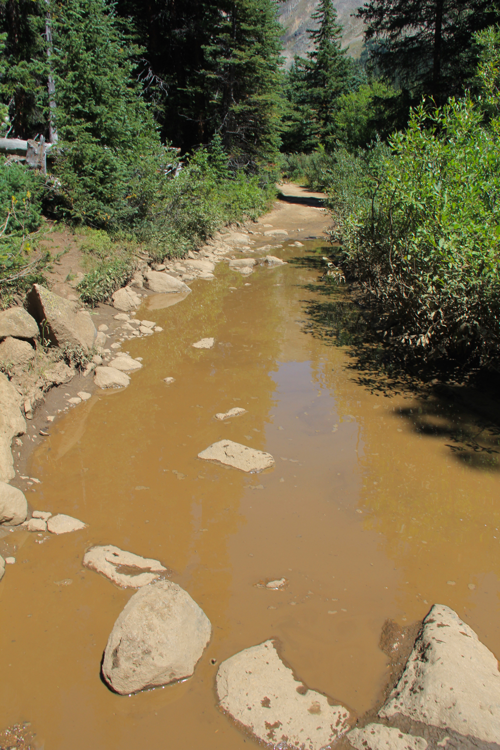
First stream crossing. This plank leads to a round log half way across. 
This road crosses Chihuahua Creek twice (at 1.2 and 2.0 miles) and in both cases, the water is deep, even in late summer. After seeing the extent of the beaver activity throughout the valley, I doubt the creek ever dries out. Water shoes and a pole are a must unless you don't mind wet feet. At the lower crossing, someone had tried to put a plank across to a large fallen log in an improvised bridge, but this structure will not survive next spring's run off. At the upper crossing, there were a few rocks that the more nimble were able to navigate. I found myself slipping off them into the water anyway.

Rutted section of the jeep road
In addition to these stream crossings, there are several places where the road itself is habitually flooded. Short social trails into the willows avoid the deepest areas but others require more slogging through bogs.

Gray and Torreys comes into view
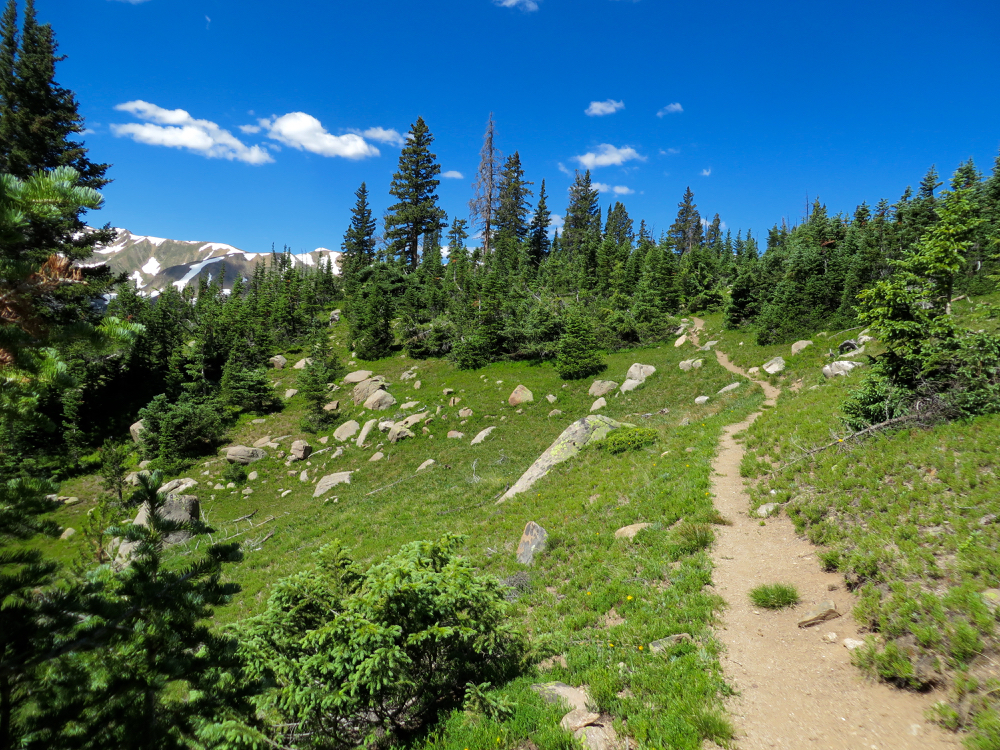
At 2.7 miles the jeep road ends at a small parking area with a wooden fence and small sign pointing upwards. Technically, this is the start of the trail, but only true 4x4s can make it to this point. For the next half mile, the trail struggles relentlessly upwards on a steep and highly eroded path reminiscent of an approach to a 14er. This segment ends at a narrow tundra shelf surrounded on both sides by barren peaks.

Soggy section
Saddle between Grizzly  and Torres Peaks
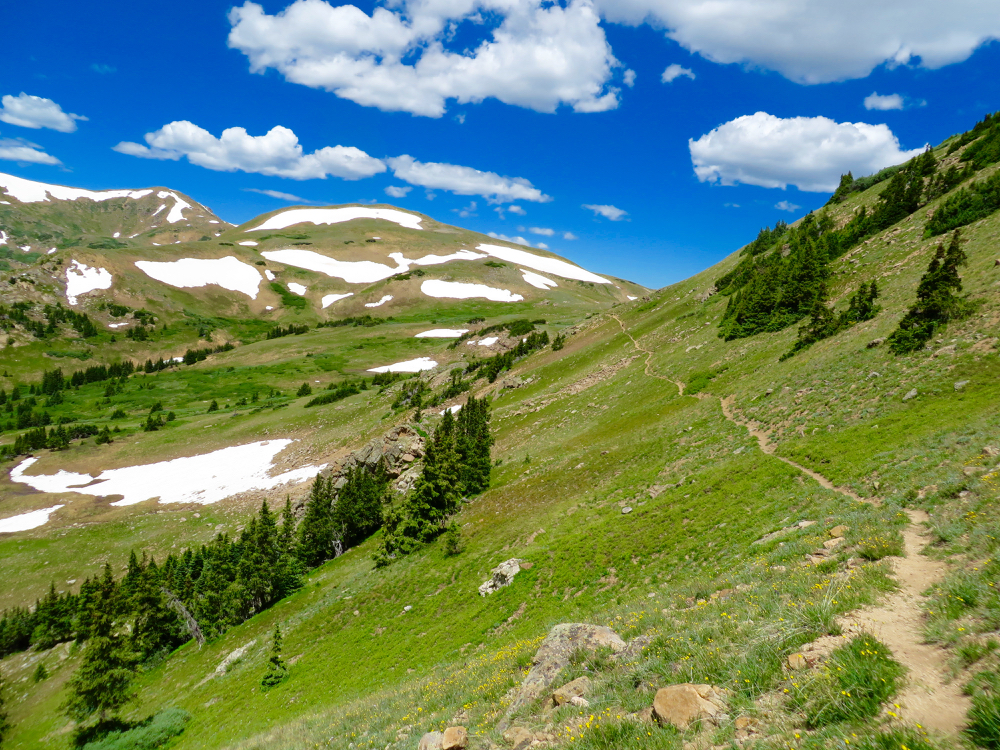
The trail continues eastward along this shelf before turning sharply upwards on the last scramble to the lake. As you approach this area, it is difficult to tell where to leave the flat and head upwards. Several narrow, eroded drainages pour down the hillside and look like a trails. Fortunately, two people were ahead of us and we followed them to the far eastern side of the valley where the grade is less vertical. Careful scouting will reveal the route that is mostly over scree but occasionally dirt. The last 100 yards is very steep, often requiring the use of hands to pull oneself upwards. Anyone with moderate fitness can navigate this section without difficulty if they take care to keep from sliding down in the loose dirt.

Trail sign and wooden fence
Heading up rocky segment to final shelf
After the scramble, the trail continues upwards for another quarter mile before cresting on a high cliff overlooking the lake. A journey down to the water requires additional scrambling down a passable gully.

Looking back down the valley and beaver ponds below
Torreys and Grays are even closer now
Chihuahua Lake has been on my do list for a long time. I never seemed to be around at the end of the season when I had assumed the water crossings would be more manageable. Now I know that they will most likely always be there, so you just have to plan accordingly. The obstacles, while annoying, are not particularly difficult to surmount and the views of Grays and Torreys are something to behold. The saddle between Grizzly Peak and Torreys is so small and easily scaled that it makes you want to run up to the summit and down again in a fit of joy.

On the final pitch before the lake
Chihuahua Lake
To get to the trailhead, take exit 205 off of I-70 (Silverthorne/Dillon) and travel east on highway 6 toward Keystone. Just past Keystone, turn right onto Montezuma Road (County Road 5). Follow Montezuma Road for approximately 4.6 miles and turn left onto Peru Creek Road (FSR 260). Follow Peru Creek Road for approximately 2.1 miles and park along the side. The only marker that you have reached the parking area is a small brown sign on the road to the left with the number 261 on it. Other cars will be your biggest clue. Peru Creek road is passable with a passenger car to this point but can be rutted and full of washboards.

Sunday, October 23, 2016

Loveland Pass West

Distance: 3 miles round trip
Elevation: 11,990 ft - 12,457 ft
Elevation Gain: 467 ft (net) 1062 ft (cum)
Bathroom at Trailhead: No
Dogs: Off leash
Tags: #coloradooutdoors, #hiking, #tundra
Nearby hikes: Upper Straight Creek, Mt. Sniktau, Herman Lake

The high tundra world along Loveland Pass West
Loveland Pass West is breathtaking high tundra hike that almost anyone with a moderate level of fitness can do since it starts way above tree line on Loveland Pass itself.

Looking across the road to the trailhead. Trail goes around to the right of the hill. 
Going around the initial knoll. Trail goes sharply up the hill in the distance. 
While short, this trail is not flat! The first 0.7 miles are the hardest, gaining 414 ft in a heart pounding climb to a small hill. You will immediately loose this well earned gain by dropping down the other side only to climb again to the broad U-shaped ridge that will form the rest of the hike.

Heading up the initial steep pitch
On the ridge looking that the route
You won't be alone on the first 0.7 miles of the journey. Instead you will be surrounded by hordes of tourists in flip flops, walking their small dogs up for a glimpse of the high country. Few make it past the first ascent, however and those that do are serious hikers.

Further along
Heading up a "false summit"
Once on the ridge, the trail weaves up and down several small hills until it dead ends at a small rock shelter on an unnamed 12K ft peak. On the one way trip you will gain 824 ft but will have climbed a total of 1,062 ft by the time you return.

At the final destination. Rock shelter in sight. 
All along the journey, views abound. There is nothing like a summer time jaunt along the Continental Divide. Tundra flowers bloom in rainbow colors and fluffy white clouds dot the horizon. Keep and eye out for more ominous grey clouds, however,  since there is no place to hide on this trail.

View to the west from the destination. 
To get to the trailhead, take the Loveland Pass road out of Keystone CO or off of I-70 just before the Eisenhower Tunnel. Parking is very limited at the pass so arrive early or in the late afternoon for a better chance of parking. The trail starts next to the Loveland Pass sign and initially wanders around the small knoll next to it. Across the road is the trailhead for Mt. Sniktau, a much harder climb. Still you will see the tourists struggling up the initial 1000 ft climb that is not for the feint of lung.

Sunday, October 9, 2016

East Snowmass Trail

Distance: 5 miles round trip (out of a possible 17 miles)
Elevation: 8,360 ft - 9,676 ft
Elevation Gain: 1,316 ft
Bathroom at Trailhead: No
Dogs: On leash (Wilderness)
Tags: #maroonbells, #coloradooutdoors, #hiking

Rare open view along the lower portion of the East Snowmass Trail
The East Snowmass Trail, near the Snowmass Ski Resort is a long connector trail mostly used by backpackers. It technically ends at Willow Lake, on the other side of East Snowmass Pass, 8.5 miles away. Day hikers can go as far as they want, however. I ended up on this trail on a drizzly day in Snowmass when I needed some exercise close by.

Trailhead
The East Snowmass Trail is entirely in the trees. Sometimes it ascends through dense Lodgepole, other times through towering Spruce and Fir and at other times through airy Aspens.  In many places a dense undergrowth crowds the trail, which in fall contains multi-colored berries. The trail is pretty much a continuous climb with a few lung busting segments.

Typical segment in a Lodgepole forest
There are a couple of minor milestones on this short excursion. It is 0.73 miles to the Wilderness boundary and 1.3 miles to the junction of the Snowmass Ditch Trail.

Example of an area in Aspens
East Snowmass Creek is ever present but in most cases far below the hiker. Still its calming sounds can be heard drifting upwards and echoing off the valley walls. The trail passes through one or two "clearings", which consist of open areas filled with tall grasses. Most were on steep slopes with occasional views down valley or of the ruby red eastern wall. We stopped for lunch in one of these clearings and had a hard time finding a place to sit, the grasses were so high.

Dogwood (Cornus sericea). Can grow over 6 feet tall. The berries persist into winter. 
Mountain ash (Sorbus scopulina).
To get to the trailhead, head west out of Snowmass and veer right onto Divide Road at the end of the valley. Just past the Krabloonik Restaurant restaurant, the road becomes dirt and heads sharply downwards. While passable with a passenger car, the road does have several sharp switchbacks and contains some clay, which will make it tricky when wet. The road forks while still descending. Stay to the left. The trailhead is only 100 yards beyond the fork. Park on the side of the road by the kiosk.

Sunday, September 25, 2016

Bowman's Cut

Distance: 6.2 miles round trip
Elevation: 10,883 ft - 11,744 ft
Elevation Gain: 861 ft
Bathroom at Trailhead: No
Tags: #coloradooutdoors, #hiking
Nearby hikes: Shrine Mountain, Shrine Mountain East, Wilder Gulch, Ptarmigan Pass

Gore and Tenmile Ranges from the top of Bowman's Cut
Bowman's Cut near Vail Pass takes you through the trees to a long open meadow. A short off trail walk to the top a small knoll capped with a campfire ring enchants with a north-south view of both the Tenmile and Gore Ranges. To the south Mount of the Holy Cross is visible.

Trailhead
For those who like walking in the forest, Bowman's Cut has a lot of appeal. The trail itself is covered in pine needles and generally soft. The forest is open and airy allowing dappled sunlight to highlight varied forest undergrowth and wildflowers. Additionally, large decaying logs dot the landscape providing an attractive window into the importance of death to a forest ecosystem. Note, if the forest is not for you, the nearby Shrine Mountain trail spends much of its time above tree line.

Typical segment in the trees
Unfortunately, the preponderance of decay seems to breed Snipe Flies, whose larvae are thought to live in downed trees where they feed on other insects until they emerge to suck your blood with a vicious bite you won't forget. Because of this, long pants and long-sleeved shirts plus a little chemical warfare in the form of DEET is recommended in summer.

The long meadow
At 2.6 miles the trail breaks out into the meadow. At 3.1 miles is a small wooden post marking the end of the meadow. From this point on the trail returns to the trees until it descends to Two Elks Pass. We chose to turn around at the sign. Note the knoll with a view is to the right just as you enter the meadow. There is no trail, just wander across the tundra. A large campfire ring marks the spot.

The wooden sign marking the end of the meadow
Bowman's Cut is also used by mountain bikers, which use it as a connector to the Two Elks Trail that travels from Vail to Minturn. The few who passed us were all very polite.

Even in late summer, the meadow contained wildflowers
To get to the trailhead drive west on I-70 to exit 190 for Vail Pass. Turn west onto Shrine Pass Road, a dirt road passable with passenger cars. At 2.3 miles pass the trailhead for Shrine Mountain and Shrine Mountain East. There is a bathroom at the east side of this lot. At 3.7 miles, pass the Holy Cross Scenic Viewing Deck and at 3.9 miles turn right onto Lime Creek Road. This road is a little rougher but still passable with a low clearance vehicle. At 4.4 miles total the trailhead will be on the right marked by a small wooden sign. Park along the side of the road. There is space for around 5 cars.

Sunday, September 18, 2016

South Saint Vrain

Distance: 6 miles round trip
Elevation: 8,700 ft - 9,692 ft
Elevation Gain: 992 ft
Bathroom at Trailhead: No
Dogs: Off leash
Tags: #coloradooutdoors, #hiking, #dogfriendly
Nearby Hikes: Buchannan Pass, Caribou Ranch

The South Saint Vrain Trail is mostly forested but is a great place to let your dog run off leash.
The South Saint Vrain Trail near Ward, CO is a decent place to let your dog roam free. There are no killer views but there is a creek, whose pleasing sounds provide a restful backdrop and water for fido.
This trail is actually quite long, and connects with the Brainard Lake area (12 miles round trip). This post profiles a shorter excursion through the forest starting at the east end near County Road 96.

Trailhead
Blue Columbine dot the forest floor
Starting from the east end, the first mile travels through a lush forest dotted with colorful undergrowth. The South Saint Vrain Creek stays to the left and provides the perfect habitat for local Black Bears (one was reported by another hiker on the trail).

Much of the forest is open and airy
At 2.2 miles, the trail leaves the forest, joining a dirt road that takes tourists to nearby private Stapp Lakes. Just before this property (at 2.7 miles), the trail turns sharply uphill and scrambles through dense Lodgepole Pines. Biting flies seem to inhabit this section as if encouraging unwelcome hikers to quickly bypass the lakes. Long pants, long-sleeved shirts, and bug spray are recommended in summer.

View of the creek
On this trip we turned around deep in the forest at 3 miles. For those who want a longer hike, you can continue all the way to Brainard. Note that at  3.1 miles the trail crosses the Sourdough Trail and then after another mile intersects the Waldrop Trail.

Where the trail becomes a road
Turn off the road and up into the forest to avoid Stapp Lakes
To get to the trailhead drive 13 miles north of Nederland on Colorado Highway (CO) 72 past Ward. Continue north for another 2.5 miles and turn west onto County Road 96 (look for the Boy Scout Camp sign). The trailhead is on the left hand side just across a bridge very close to CO 72. Park on the side of the road. I was quite surprised at how busy this road was so be careful when exiting your vehicle.

Our turn around point. The trail is much rockier on the lake bypass

Wednesday, September 7, 2016

"Vasquez Peak Pass" (Continental Divide Trail)

Distance: 8 miles round trip
Elevation: 10,546 ft - 12,000 ft
Elevation Gain: 1,454 ft
Dogs: Off leash
Bathroom at Trailhead: No
Tags: #coloradooutdoors, #CDT, #tundra, #empire
Nearby hikes: Butler Gulch, Stanley Mountain, Vasquez Pass, Jones Pass

View of the Continental Divide on the way to "Vasquez Peak Pass"
The trail to "Vasquez Peak Pass" is a stunning jaunt along one of the prettiest sections of the Continental Divide Trail (CDT) that is not in a wilderness area. This is a boon to dog owners who need to let Fido run free. Located near the Henderson Mine (between Empire, CO and Berthoud Pass), this hike travels 1.5 miles up the Henderson Spur Trail to the CDT and then heads northwest to an unnamed pass to the west to Vasquez Peak for a total one way distance of 4 miles.
The dead Bristlecone forest
I have called the destination of this hike the "Vasquez Peak Pass" to distinguish it from Vasquez Pass, which is located in the same area but which lies between Stanley Mountain and an unnamed 12K ft peak (see photo of map). Don't blame me, but the person undoubted experimenting with LSD for these lovely catawampus names.

Map of the area showing "Vasquez Peak Pass" (red circle) versus Vasquez Pass to the right.
The Henderson Spur Trail winds quickly upwards through a series of switchbacks in a dense Lodgepole and later Spruce forest. At 1.5 miles is the intersection with the CDT. There used to be a large wooden sign marking the spot but this was missing on my last trip. Instead look left and you may see a small CDT marker high up in one of the trees around 40 yards up the trail.

Breaking out of treeline
At 2 miles the CDT trail enters a dead Bristlecone forest. It takes Bristlecones a long time to decay so the skeletons of this once vibrant forest will be with us for generations to come.

Starting to head northwest
After the forest, the trail quickly leaves tree line and winds around the northeast side of broad valley bordered on both sides by the snow-covered peaks of the Continental Divide itself. Alpine sunflowers dot the meadows in summer and in fall, the tundra grasses turn a rudy brown. Even in late summer there are streams for Fido to enjoy.

Alpine Sunflowers
The pass itself is just beyond a large jumble of rocks and looks back down the valley to the south and deep into the Vasquez Peak Wilderness to the north. From this point the CDT travels around a small 12K ft peak that would be an easy scramble for those wishing to go higher.

Large rock pile
There is no defined trail up to Vasquez Peak and while the Trails Illustrated map shows an undefined trail leading up from the pass, it would actually be easier to bushwhack up to the ridge to the south and ascend from there.

The pass is in sight
The Vasquez Peak Pass trail is a great way to avoid the crowds (I saw one ultra runner) while breathing in crisp tundra air. It is highly recommended for anyone wishing a quick escape from the searing Denver heat.

Looking north from the pass
To get to the trailhead, take I-70 west from Denver and then Highway 40 through Empire. Past Empire the highway turns sharply in what is now as the Big Bend. Exit here. The signs point to the Big Bend picnic ground as well as Jones Pass. Just before the Henderson Mine, a dirt frontage road starts off to the right. Follow this for less than a mile to a large parking area. There is a small wooden sign on right under some power lines. This lot also serves Butler Gulch and so may be more crowded than expected.

North Rock Creek Snowshoe

Distance: 4 miles round trip Elevation: 9,180 ft to 9,780 ft Elevation Gain: 600 ft Dogs: Off leash until the wilderness boundary North...