Saturday, June 16, 2012

Hanging Lake

Distance: 3 miles round trip
Elevation: 6,143 ft - 7,251 ft
Elevation Gain: 1,108 ft
Dogs: On leash
Bathroom at Trailhead: Yes

Hanging Lake ner Glenwood Springs CO is a classic hike
Bridal Veil Falls form the backdrop of mysterious Hanging Lake
Hanging Lake is a mysterious destination tucked into a crenelation of Glenwood Canyon near the town of Glenwood Springs.  It is mysterious for the aqua and teal color of its waters and for the tropical feel of the two water falls that form its backdrop.  It is also mysterious because it is not easy to get to.  For anyone who has driven through Glenwood Canyon, you know about the two elevated highways that weave around and across the Colorado River. Because of this, there is only one way to the trailhead, and that is from the east bound span.  After your hike, it is necessary to travel ALL THE WAY back to Glenwood Springs to head east again if that is the direction you need to go.  A similar frustrating round-a-bout is necessary if you are traveling west.  You have to travel to Glenwood Springs and then turn around and travel back east to the trailhead.  This destination is so cool, however, that you really won't care that much.

The rest area with its bathroom
Starting out on the bike trail
The trailhead is accessed from the Hanging Lake Rest Area with its picnic tables and restroom.  The trailhead is 0.25 miles up the Glenwood Canyon bike path, which travels the entire length of the canyon (12.5 miles).  The trailhead if obvious.  There is a bike ride and large trailhead sigh, which warns hikers of the strenuous nature of the trail.  It is 1.2 miles from here to the lake.

Moon  next to one of the towers of Glenwood Canyon.  Note the layers of sedimentary rock in the lower  right.  Glenwood Canyon was formed by the Colorado River cutting through layers of Pennsylvanian and Mississippian Sandstone. 
The Colorado River.  I really want to ride the 12.5 mile bike that that travels through the canyon.   Last year (2011) it was closed due to high water.  
The trail to Hanging Lake IS steep, but is certainly no worse than Boulder's Royal Arch or Saddle Rock trails.  Almost anyone with some level of fitness and a full day to spend can make it to the lake.  Dawdling is for Texans however.  Coloradans should bag the scenic nature of the trail, grab a defibrillator, and hustle up the trail as fast as possible.  You can gaze at pleasant Dead Horse Creek and looming rock walls on the way down.  Maximum burn and cardiovascular distress should be your goal on the way up.  Since I was on my way back from Arches National Park and did not bother to bring any water with me, this was my plan.  I definitely smoked the numerous families and occasional grand ma mas that littered the trail like beer cans after the Sturgis Bike Rally.  Hanging Lake may be mysterious but it is certainly not undiscovered.

The early part of the trail is exposed and traverses a large tallus pile. 
The trail follows pleasant Dead Horse Creek.  Several bridges take the hiker back and forth across it.  
Most of the trail is rock steps with a few bridges that traverse the creek.  After 1.1 miles, a tall, precipitous staircase takes the hiker the last 50 vertical feet to the lake.  If you are not freaking out over the drop off, take a second to admire the view of the canyon walls.  The geology of Glenwood Canyon is a wonder of Colorado.  I for one was gasping and grasping at the handrail, having forgotten this short but nerve-wracking pitch.  The ascent takes seconds, blessed be, and then you are at the lake.

Much of the trail is in the trees
A small shelter hugs one wall of the canyon
A nice Trex deck with equally pleasant benches lines the lake so you can gaze at the pond scum that lines the border.  What eery denizens live in these wildly colorful waters?  Stay at the lake after dark and you may find out the hard way!

A more manicured trail segment
There is a large log that bisects the lake and in my short time there I saw more than one crazy tourist try to walk out on it.  While certainly damaging to the psyche, a fall into Hanging Lake is more likely to affect the local critters so please be kind to the green slime that really doesn't want to be bathed in human excretions.

The view of the Dead Horse Canyon from the stairs
Heading up the narrow, rough cut steps
I did see people climbing up above the waterfalls, so there is a route up there, but I was in a rush, so I did not try to find it  It was actually cold the day I did this hike, and breeze became colder after blowing across the water.  So don't let the tropical ambiance fool you.  This destination can be nippy so plan accordingly.

"Pond Scum" adds to the colorful nature of Hanging Lake
The right side of the lake is dirt.  Note the Trex deck along the far edge.
The shelf holding the lake against the walls is formed by Travertine, a limestone deposit that is known to form shelves near hot springs (think Yellow Stone National Park or Havasupai Falls).  It is extremely fragile, which is why the deck was built and tourists are asked not to enter the water.

Heading back down the steep staircase.  Those handrails come in handy.  
A couple of Golden Mountain Ground Squirrels in the parking lot.  
Hanging Lake is one of the 100 classic hikes of Colorado.  In 2011 it was made a Natural Natural Landmark.  Don't pass this up if you are in the area.

Wednesday, June 13, 2012

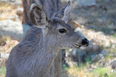
Mule Deer

I cam across this small herd of Mule Deer (Odocoileus hemionuson) the Hogback Trail north of Boulder. They slowly got closer and closer to me until they were less than 10 feet away. That shows how used to people they have become.


Read my previous post on Mule Deer to learn about their ecology.

Saturday, June 9, 2012

Utah: Sego Canyon

Distance: 0.5 miles
Elevation Gain: negligible
Dogs: Allowed
Bathroom at Trailhead: Yes

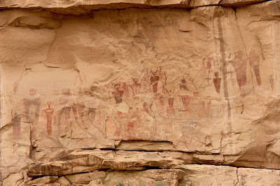
The spooky panel of Barrier Style pictographs found in Sego Canyon.
The spooky panel of Barrier Style pictographs found in Sego Canyon.  Each one of these figures is about three feet tall. 
A trip to Sego Canyon north of Arches National Park in Utah will either have you believing in ancient aliens or wishing you could order a package of whatever the painters were smoking. The cliff faces around the canyon are covered in Indian pictographs, some traditional (e.g. horses and men) and some outright bizarre (the afore mentioned aliens).  I have seen these images on television and the Internet, but nothing compares to seeing them in person.  The alien looking ones in particular are really BIG, which just increases the tingling of the hairs on the back of the neck.

Ute Indian Pictographs.  You can tell it is the most recent because of the depicted horses.
Yellow Rabbitbrush and Sagebrush dominate this shot looking out the canyon
Finding Sego Canyon can be as hard as finding evidence of UFO visitations.  It is not obvious.  Coming from the east, it is one exit beyond the Utah visitor's center.  This exit, for Thompson Springs Utah, dumps you into a town 2 seconds away from total abandonment. Signs hang from their hinges, grass grows in the cracks of the road, and leaves rustle in the corners of the buildings.

To the right of the Ute panel is a panel from the Fremont Period.  This culture pre-dates the Utes.  It is believed these Indians were contemporaries of the Ancestral Puebloans.  
A Plateau Lizard lounges on one of the railings guarding the panels
There is no sign pointing to Sego Canyon and no real indication of where to go.  I bravely drove through town until I found a small BLM sign pointing the way.  It was a total leap of faith to get that far.  Once in the canyon, you arrive at a trailhead with a small bathroom and parking lot.  From there it is a matter of wandering around the small trails in search of the pictographs.  Be aware that the most interesting images are not visible from the parking lot and are in fact on faces "around the corner".

The dark red image on the right is my favorite of the bunch.  Its insect like head is beautiful in a nightmarish sort of way.  Maybe I don't want to be smoking the ancient weed if this is the sort of image my imagination might conjure up.  
Are these images of aliens in space suits?  To the modern eye the appendages could be hoses and antennae.  
The art in Sego Canyon dates from four different periods. The images near the bathroom are from the Ute period (after 1300 A.D). You can tell these are the most recent images because they includes horses, which did not arrive in North America until the Spanish invasion. There is also rock art from the Barrier Canyon period from 4000 to 2000 B.C. and the Freemont period dating from A.D. 600-1250.  The Barrier Canyon art is very unique.  It is concentrated in this area of Utah with some stunning panels in Canyonlands National Park.

In this photo you can see the size of these images which are located across the valley and behind a  livestock corral.  Touching the images is not a good idea.  The oils from the skin can damage the paint.  Note the gun shots of some seriously stupid people with no appreciation for our American Indian heritage.  
The images in Sego Canyon have existed for thousands of years.  It only takes a modern human five minutes to deface them.  The American Southwest is littered with these sites.  Most will hopefully stay hidden for a long time to come.  
At the time of my visit, a large shrub was flowering, spilling its honey like sent into the air.  It was almost intoxicating.  After wandering through the bushes for an hour or so I was starting to get light headed and the figures on the wall were starting to shimmer in the haze.  Hmmmm, was I drunk on nature or had I found that alluring substance I mentioned earlier?  You are just going to have to go to Sego Canyon to find out for sure. 

Saturday, June 2, 2012

Arches: Delicate Arch

Distance: 3 miles round trip
Elevation: 4,280 ft - 4,815 ft
Elevation Gain: 601 ft (cumulative)
Dogs: Not allowed
Bathroom at Trailhead: Yes
Water at Trailhead: No

The world famous Delicate Arch in Arches National Park. 
Delicate Arch is a superstar destination that half the world can recognize.  It is the centerfold in many a landscape calendar and it seems like every professional photographer has a shot in their portfolio.  It was Delicate Arch that drew me to Arches National Park.  Its ubiquitous image was taunting me.  Here this place was, only 5 hours away and I had never seen it.

The trailhead
Blow up this picture and you will see the trail wind through the desert and up to the sloping slickrock face in the distance.
There are several places where you can view Delicate Arch from a great distance.  Both of these spots require that you drive by the main trailhead.  I did this early in the morning on my way to Double Arch and the Windows.   The view reminded me of pictures of the Klondike Gold Rush with a continuous line of hikers...buttocks to buttocks winding up a long slab of slickrock.  The prospect was not appealing.  Fortunately, by the time I returned in the late afternoon, the crowds had diminished.

Heading up the slickrock hill
Delicate Arch was the last hike on my hiking marathon and I was tired and grumpy.  I had planned it this way however, knowing that there was no way I would bail on this trail.  I wolfed down a couple of chocolate chip cookies I had saved and started up the trail just in time to join a group of bikers who did not look like they walked from their bikes to the nearest bar let alone up a trail.  As tired as I was I WAS NOT about to let this group of strollers beat me up the hill.  There were no worries there, I passed them in the first quarter mile and did not see them again.

Unless there is a blizzard blowing, you will not be alone on the Delicate Arch trail.
The initial part of the trail winds steeply up a wide dirt road that switchbacks several times before transitioning to the tall slickrock hill.  It was here that I met a woman in high heel shoes.  Her perfectly painted toenails were visible in the open toe and she was dressed for an evening out in South Beach.  I goggled aghast.  "Did you do this trail in those shoes?" I could not help but ask.  She smiled proudly and said yes.  It was not their plan but they had just kept going.  "You go girl!" I exclaimed in amazement as her Cuban night club owner of a husband beamed and jiggled his gold chains.  Don't try this at home children, she is lucky she did not break a leg.  The sandstone face is steep.

After the slickrock hill, the route travels through this gully en route to the hoodoos in the distance.
There really is no required route up the face, but it obvious where the millions have gone before. Like the ruts of wagons still visible along the Oregon Trail, the soft rock is being worn down bit by bit and a smooth if not indented pathway is clearly visible.

At the top of the slickrock hill, the route curves to the left and winds between a series of hoodoos and Utah Junipers.  It is worth while pausing here to look back toward the trailhead and the surrounding canyons.  The trailhead is just a dot now.

The approach to the hoodoos is across another sandstone plateau.  Note the cairns heading off into the distance.
A more imaginative cairn.  The initial sandstone bench is just ahead.
Past the hoodoos, the trail climbs up onto a slickrock bench.  The ascent has been carved into the rock but the bench itself is slightly sloped.  I ended up walking along the upper side of it, which was not a good choice.  Keep to the lower side even though it is closer to the edge.

This bench quickly becomes a superhighway carved into the rock.  This section is relatively wide but does travel along a sheer 1000 foot drop off.  Everyone hugs the inner wall, which means continuous games of chicken as hikers fight to retain the inside lane.

Rock steps up to the bench
The rock superhighway.  It leans into the cliff instead of into the drop off so no counseling required after passage.
This rock superhighway is blessedly short but does weave and curve a bit.  At the end, the rock face suddenly peels away like the sliding of a closet door to reveal the arch.  It is so unexpected and so huge that it is shock to the senses.  It takes a second for the arch to retreat across the wild bowl it accents.  There is an area of wide flat rocks to lean again on this side of the bowl and most people lunge forward and grasp them gratefully.

The iconic composition of Delicate Arch with the La Sal Mountains framed by the arch itself.  
The sandstone bowl is very steep.  No one was heading down into it.
After breathing in the view for a while, I grabbed the camera and ventured to the other side of the bowl.  This spot is an amphitheater for the Nature's spirits and waifs.  You can sense they gather there in the dark of the night and during storms that keep prying eyes away.

Sunset is the best time to photograph Delicate Arch, but I decided not to wait nor bring my tripod.  The reality is that I am a hiker who takes photographs rather than a photographer who hikes.  Still, by waiting until late afternoon, I did manage to avoid the crowds and get a little light reflecting off the stone.

The arch from another angle
The arch is out of view to the right.  This is the view into the valley below.  Most people forget to admire the desert around the arch, but it has beauty too.
Delicate Arch is one of Mother Nature's wonders, so if you are in the area, don't hesitate to pop into the park and join the hordes on this trail.  Most people, even the unfit, can manage to struggle up the hill to view this marvel.  Just leave the high heels at home.

North Rock Creek Snowshoe

Distance: 4 miles round trip Elevation: 9,180 ft to 9,780 ft Elevation Gain: 600 ft Dogs: Off leash until the wilderness boundary North...