Saturday, June 23, 2012

Devil's Backbone

Distance: 4 miles round trip
Elevation: 5,100 ft - 5,450 ft
Elevation Gain: 350 ft
Dogs:  On leash only
Bathroom at Trailhead: Yes
Date Hiked: 20 April, 2012

Gazing down at the Devil's Backbone hogback formation from across the valley.
Devil's Backbone is a unique open space near the town of Loveland Colorado.  The backbone is a really a hogback in geological parlance, which just means a sharply tilted chunk of rock protruding out of the surrounding landscape.  Colorado is awash in hogbacks and the Devil's backbone is a particularly attractive one.  

The trailhead has bathrooms, signage and a large parking lot.  
The first part of the trail is wide and welcoming.  You won't get lost in this park. 
Deposited during the time of T-Rex, the rock that is now vertical was actually the shore of an inland sea that covered a portion of what is now the Great Plains of the U.S. The wonders of geology have taken the flat layers and tilted them upwards so that they rise over 200 feet above the surrounding meadows.

First view of the formation.  Surely a giant mythological creature is going to rear out of the ground at any second. 
A zoom shot of the formation
There are many ways to enjoy the Devil's Backbone Open Space.  The Wild Loop (2.6 miles total) is a short hike that will take you close to the formations on one side and further out into the open meadow on the other.  We chose to continue past the end of this loop and across the valley.  From there, the trail heads up to the top of an escarpment where it weaves northward seemingly forever until it meets the Rim Rock Open Space.  That distance is really only suitable for mountain bikers.  Hikers will end up returning much earlier.  There are two loops in the mid-section of the open space, the Hunter Loop and the Laughing Horse Loop.  The area is not well marked and we actually thought we had made it to the Laughing Horse section because there was at least one unmarked loop as you head up the escarpment.

Looking out into the meadow from the Wild Loop Trail.  Just out of frame to the right  is a long series  of very expensive homes. 
There is a short spur trail off the upper Wild Loop that takes you to a view point looking west.  This spot is on a small rise between the formations. 
When you reach the junction of the Hunter Loop, the section heading straight travels along the hill side with views of the Mc-Mansions that have been built in the area.  Having walked a short distance in that direction we decided to turn around and take the section heading further up the escarpment.

Sand or Star Lillies (Leucocrinum montamum)  have been common this year. They grow in sandy soil  and Sagebrush communities.
Trail sign showing our location at the end of the Wild Loop.  You can see the open space continues on for quite a distance. 
Once we gained the top of the escarpment, we could see that the trail just continued on through the Sagebrush.  The route was rocky and numerous mountain bikers passed us.  We walked a little further and then decided to turn around.  Since it was already late afternoon this was a good choice.  It was a long drive back down to the Denver Metro Area.

Leaving the Wild Loop and heading across the valley to the escarpment in the distance
A steeper, rockier trail segment
My hiking companion told me that the trails were very different since the last time she had been there.  The route keeps you away from the rock formations with the exception of one spur to a hole in the rock.  This spur was closed when we were there to protect nesting raptors, so don't expect to channel a Cretaceous dinosaur by hugging the rocks themselves.  You can look, but you can't touch!

A view of the formation from across the valley
The straight part of the Hunter Loop heads towards these houses.  We chose to turn around and head up the hill to the top of the escarpment, which is dramatically visible in the distance.  
The trip across the valley was a way to add mileage to this short excursion and did provide some nice views of the surrounding area as well as the backbone itself.  There is no shade in this area, so go in the spring or fall when temperatures are reasonable.

Our turn around point.  The trail continues on forever....
If you like hogbacks, check out the Hogback Trail just north of Boulder and Matthew Winters Park near Golden.

Wednesday, June 20, 2012

Raven

The Common Raven (Corvus corax) swooped by as I got too close to its nesting tree. 
Oh the poor Common Raven (Corvus corax)!  It is big and black and binges on road kill.  To the species that created the white leisure suit, the speedo,  and the need to wear one's pants sagging below one's gluteus maximus, the Raven is sadly devoid of bling.  It is however, highly intelligent, which is more than I can say for the designers of the afore mentioned fashion disasters.  I must be a good little fashionista however, because the Raven, while common in Colorado, just does not draw my eye.  I see this bird quite a lot, and hear its raucous cry even more, but my mind glazes over at the mere thought that it is only a mere Raven.
The typical profile of a Raven...perched in a tree, its large beak dominating its face. 
The Norse god Odin would be ticked off -- in the way that only gods with lightening bolts can be -- if he knew of my professed ennui towards his favorite birds.  His pets Huginn and Muninn traveled the world spying on us humans.  Odin was not the only god to love Ravens.  They are featured prominently in many cultures as tricksters, lost souls, and the ghoulish familiars of evil-minded spirits.  Geesh, and this is just a bird!

The Raven is very acrobatic with large and visually obvious flight feathers. 
Non-mythological Ravens have been known to frolic in the snow like children, chatter incessantly on light poles like teenagers, and finally settle down with the right girl for life.  They can mimic human speech but their cawing, screeching, and shrieking sounds more like the political banter on Fox News and CNN.  There are times I yearn for the mute button.  An indiscriminate eater, they will consume garbage, road kill, insects, small rodents, berries, and nuts.  The world is one big buffet to the Raven, which is why we have not managed to wipe it out just yet.

I captured the images of this Raven along a creek.  It was defending its territory every time a cyclist rode by, which probably means it was part of a nesting pair.

Saturday, June 16, 2012

Hanging Lake

Distance: 3 miles round trip
Elevation: 6,143 ft - 7,251 ft
Elevation Gain: 1,108 ft
Dogs: On leash
Bathroom at Trailhead: Yes

Hanging Lake ner Glenwood Springs CO is a classic hike
Bridal Veil Falls form the backdrop of mysterious Hanging Lake
Hanging Lake is a mysterious destination tucked into a crenelation of Glenwood Canyon near the town of Glenwood Springs.  It is mysterious for the aqua and teal color of its waters and for the tropical feel of the two water falls that form its backdrop.  It is also mysterious because it is not easy to get to.  For anyone who has driven through Glenwood Canyon, you know about the two elevated highways that weave around and across the Colorado River. Because of this, there is only one way to the trailhead, and that is from the east bound span.  After your hike, it is necessary to travel ALL THE WAY back to Glenwood Springs to head east again if that is the direction you need to go.  A similar frustrating round-a-bout is necessary if you are traveling west.  You have to travel to Glenwood Springs and then turn around and travel back east to the trailhead.  This destination is so cool, however, that you really won't care that much.

The rest area with its bathroom
Starting out on the bike trail
The trailhead is accessed from the Hanging Lake Rest Area with its picnic tables and restroom.  The trailhead is 0.25 miles up the Glenwood Canyon bike path, which travels the entire length of the canyon (12.5 miles).  The trailhead if obvious.  There is a bike ride and large trailhead sigh, which warns hikers of the strenuous nature of the trail.  It is 1.2 miles from here to the lake.

Moon  next to one of the towers of Glenwood Canyon.  Note the layers of sedimentary rock in the lower  right.  Glenwood Canyon was formed by the Colorado River cutting through layers of Pennsylvanian and Mississippian Sandstone. 
The Colorado River.  I really want to ride the 12.5 mile bike that that travels through the canyon.   Last year (2011) it was closed due to high water.  
The trail to Hanging Lake IS steep, but is certainly no worse than Boulder's Royal Arch or Saddle Rock trails.  Almost anyone with some level of fitness and a full day to spend can make it to the lake.  Dawdling is for Texans however.  Coloradans should bag the scenic nature of the trail, grab a defibrillator, and hustle up the trail as fast as possible.  You can gaze at pleasant Dead Horse Creek and looming rock walls on the way down.  Maximum burn and cardiovascular distress should be your goal on the way up.  Since I was on my way back from Arches National Park and did not bother to bring any water with me, this was my plan.  I definitely smoked the numerous families and occasional grand ma mas that littered the trail like beer cans after the Sturgis Bike Rally.  Hanging Lake may be mysterious but it is certainly not undiscovered.

The early part of the trail is exposed and traverses a large tallus pile. 
The trail follows pleasant Dead Horse Creek.  Several bridges take the hiker back and forth across it.  
Most of the trail is rock steps with a few bridges that traverse the creek.  After 1.1 miles, a tall, precipitous staircase takes the hiker the last 50 vertical feet to the lake.  If you are not freaking out over the drop off, take a second to admire the view of the canyon walls.  The geology of Glenwood Canyon is a wonder of Colorado.  I for one was gasping and grasping at the handrail, having forgotten this short but nerve-wracking pitch.  The ascent takes seconds, blessed be, and then you are at the lake.

Much of the trail is in the trees
A small shelter hugs one wall of the canyon
A nice Trex deck with equally pleasant benches lines the lake so you can gaze at the pond scum that lines the border.  What eery denizens live in these wildly colorful waters?  Stay at the lake after dark and you may find out the hard way!

A more manicured trail segment
There is a large log that bisects the lake and in my short time there I saw more than one crazy tourist try to walk out on it.  While certainly damaging to the psyche, a fall into Hanging Lake is more likely to affect the local critters so please be kind to the green slime that really doesn't want to be bathed in human excretions.

The view of the Dead Horse Canyon from the stairs
Heading up the narrow, rough cut steps
I did see people climbing up above the waterfalls, so there is a route up there, but I was in a rush, so I did not try to find it  It was actually cold the day I did this hike, and breeze became colder after blowing across the water.  So don't let the tropical ambiance fool you.  This destination can be nippy so plan accordingly.

"Pond Scum" adds to the colorful nature of Hanging Lake
The right side of the lake is dirt.  Note the Trex deck along the far edge.
The shelf holding the lake against the walls is formed by Travertine, a limestone deposit that is known to form shelves near hot springs (think Yellow Stone National Park or Havasupai Falls).  It is extremely fragile, which is why the deck was built and tourists are asked not to enter the water.

Heading back down the steep staircase.  Those handrails come in handy.  
A couple of Golden Mountain Ground Squirrels in the parking lot.  
Hanging Lake is one of the 100 classic hikes of Colorado.  In 2011 it was made a Natural Natural Landmark.  Don't pass this up if you are in the area.

Wednesday, June 13, 2012

Mule Deer

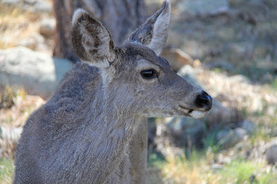
I cam across this small herd of Mule Deer (Odocoileus hemionuson) the Hogback Trail north of Boulder. They slowly got closer and closer to me until they were less than 10 feet away. That shows how used to people they have become.


Read my previous post on Mule Deer to learn about their ecology.

Saturday, June 9, 2012

Utah: Sego Canyon

Distance: 0.5 miles
Elevation Gain: negligible
Dogs: Allowed
Bathroom at Trailhead: Yes

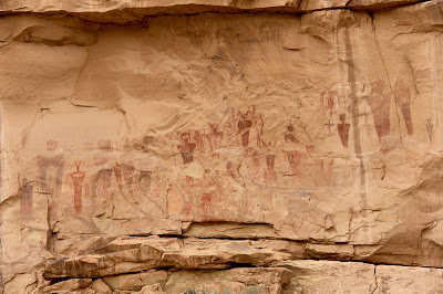
The spooky panel of Barrier Style pictographs found in Sego Canyon.
The spooky panel of Barrier Style pictographs found in Sego Canyon.  Each one of these figures is about three feet tall. 
A trip to Sego Canyon north of Arches National Park in Utah will either have you believing in ancient aliens or wishing you could order a package of whatever the painters were smoking. The cliff faces around the canyon are covered in Indian pictographs, some traditional (e.g. horses and men) and some outright bizarre (the afore mentioned aliens).  I have seen these images on television and the Internet, but nothing compares to seeing them in person.  The alien looking ones in particular are really BIG, which just increases the tingling of the hairs on the back of the neck.

Ute Indian Pictographs.  You can tell it is the most recent because of the depicted horses.
Yellow Rabbitbrush and Sagebrush dominate this shot looking out the canyon
Finding Sego Canyon can be as hard as finding evidence of UFO visitations.  It is not obvious.  Coming from the east, it is one exit beyond the Utah visitor's center.  This exit, for Thompson Springs Utah, dumps you into a town 2 seconds away from total abandonment. Signs hang from their hinges, grass grows in the cracks of the road, and leaves rustle in the corners of the buildings.

To the right of the Ute panel is a panel from the Fremont Period.  This culture pre-dates the Utes.  It is believed these Indians were contemporaries of the Ancestral Puebloans.  
A Plateau Lizard lounges on one of the railings guarding the panels
There is no sign pointing to Sego Canyon and no real indication of where to go.  I bravely drove through town until I found a small BLM sign pointing the way.  It was a total leap of faith to get that far.  Once in the canyon, you arrive at a trailhead with a small bathroom and parking lot.  From there it is a matter of wandering around the small trails in search of the pictographs.  Be aware that the most interesting images are not visible from the parking lot and are in fact on faces "around the corner".

The dark red image on the right is my favorite of the bunch.  Its insect like head is beautiful in a nightmarish sort of way.  Maybe I don't want to be smoking the ancient weed if this is the sort of image my imagination might conjure up.  
Are these images of aliens in space suits?  To the modern eye the appendages could be hoses and antennae.  
The art in Sego Canyon dates from four different periods. The images near the bathroom are from the Ute period (after 1300 A.D). You can tell these are the most recent images because they includes horses, which did not arrive in North America until the Spanish invasion. There is also rock art from the Barrier Canyon period from 4000 to 2000 B.C. and the Freemont period dating from A.D. 600-1250.  The Barrier Canyon art is very unique.  It is concentrated in this area of Utah with some stunning panels in Canyonlands National Park.

In this photo you can see the size of these images which are located across the valley and behind a  livestock corral.  Touching the images is not a good idea.  The oils from the skin can damage the paint.  Note the gun shots of some seriously stupid people with no appreciation for our American Indian heritage.  
The images in Sego Canyon have existed for thousands of years.  It only takes a modern human five minutes to deface them.  The American Southwest is littered with these sites.  Most will hopefully stay hidden for a long time to come.  
At the time of my visit, a large shrub was flowering, spilling its honey like sent into the air.  It was almost intoxicating.  After wandering through the bushes for an hour or so I was starting to get light headed and the figures on the wall were starting to shimmer in the haze.  Hmmmm, was I drunk on nature or had I found that alluring substance I mentioned earlier?  You are just going to have to go to Sego Canyon to find out for sure. 

North Rock Creek Snowshoe

Distance: 4 miles round trip Elevation: 9,180 ft to 9,780 ft Elevation Gain: 600 ft Dogs: Off leash until the wilderness boundary North...