Saturday, March 28, 2009

Day 3: Honanki Pictographs and Cliff Dwelling

Distance: 0.6 mile loop
Elevation: 4,700 – 4,750 ft
Elevation Gain: 50 ft


If you are going to Palatki, a very nice Sinaguan site, be sure to also visit Honanki. The setting is not as pretty in my mind, but the site does have better, if less historically significant, pictographs. The short trail winds through pine and shrub and was very accessible to my mother who has trouble with stairs. In contrast, she did not climb the stairs to Palatki but stayed just below communing with the lizards on the rocks.

Trail to the Honanki site

You can actually see texture and finger marks in this pictograph

Honanki ruins

Honanki is only 4.4 miles beyond Palaki, but I would recommend setting your trip odometer because that distance is deceiving when you are driving slowly on a dirt road. I kept thinking, gosh that rock formation has got to be it etc. It was not. You will recognize the site immediately and don’t be freaked out when you hit the boundary of the Handcock ranch. The route goes right through it.


The bottom row of images was not visible to the naked eye but became visible when I enhanced the colors of the picture.

One of the local tour companies takes folks to this site, so there were at least 4 tour groups on site. They are small and timed themselves pretty well, so it was not terribly intrusive. I think they are helping to fund the restoration of the area, so you can’t bitch too much about that.

The Sinaguans are gone, but the cliff dwellings are far from uninhabited.

Friday, March 27, 2009

Day 3: Palatki Cliff Dwellings and Pictrographs

Distance: 0.6 miles round trip to view the pictographs, 0.6 miles to walk the cliff dwelling loop for total of 1.2 miles.
Elevation: 4,800-4,850 ft
Elevation Gain: 50 ft.

Palatki Pictographs

If you visit one Sinagua site in the Sedona area, make it this one. The site sits beneath an 800 ft red cliff. It dominates the site and looms dramatically in the distance as one approaches it. The site has both pictrographs and a cliff dwellings but only a one-seater bathroom, so plan accordingly. You will make new friends while standing in line.

Rocks from Road 525

Road 525

You do need reservations to visit. Call (928) 282-3854 for information. The site opens at 9:30 AM but when we called at 9:45 AM we still got a recording. It is Forest Service Volunteers who man the phones and the small visitor’s station, so don’t expect the punctuality one would expect from fully pensioned Federal employees. If you do end up leaving a message like we did be sure to tell them what time you are coming because they will get annoyed if you don’t.

Cliffs around Palatki. The alcove on the left is where the pictographs are located.

Pictograph Trail

There are two ways to get to Palatki. The map you get in town advises driving up 89A towards Cottonwood. From there you need to take Forest Road (FR) 525. Note that there is a small brown sign with this number on it about 50 yards before the turn off. This is the only sign so don’t blink. FR 525 is a long dirt road passable by passenger cars as long as you don’t mind a lot of washboard jiggling. The other way to get there is via Sedona’s back roads, Dry Creek and they Boynton Pass. This is by far the more scenic route and it is paved for longer. I put detailed directions of this route at the bottom of the post. I would recommend going that way, it is just prettier.

Rocks along the pictograph trail

Ancient Scratchings

It was very pleasant out at the site. The pictographs are in two alcoves, each with a docent. The views of the area from these picturesque spots made me wish for a Barcalounger. The ancient Sinaguans understood location, location, location. Just to the left of the pictographs was a spring. So not only did they have protection and beauty, they also had running water.

View from the alcove

Giant Agave Bug (Acanthocephala thomasi). This bug drinks the nectar of the Agave plant, the source of Tequilla. Now that is my kind of meal.

The pictographs at this site are very unusual. There are bears, headless figures, and other unusual anthropomorphic figures. There are also large scratches in the wall that I thought was vandalism but turned out to be ancient and authentic. In the local Indian tradition, shamans would scratch at the walls to enter the spirit world. Some of the pictographs are believed to be several thousand years old.

Pictograph

Palatki Ruins

The trip to the cliff dwelling takes you a across an open field, across a creek, and up some steep steps to the wall. The dwelling itself is not overwhelmingly impressive but the setting is pleasing. We saw a Cardinal and a Scrub Jay on the way back to the car, so there is some wildlife in the area.

Palatki Ruins from the side

There is another site nearby, Honanki, which is not as good but since you are already there, you might as well go see it too. Just be prepared for the hordes. One of the local jeep touring companies takes folks to that site. Don't pay money for that trip, however, you can get there easily by yourself.

Directions (the more scenic route): Drive 2.9 miles up Dry Creek Road out of Sedona to the Long Canyon intersection. Stay left and drive another 1.6 miles to the Boynton Canyon intersection. Go left and drive another 4 miles to the intersection with Forest Road 525. 2 miles of this last pitch are on a dirt road. The dirt continues to the site. 0.1 miles from the 525 intersection is a fork. The right fork goes to Palatki, the left to Honanki. It is 1.7 miles on the right fork to the site.

Wednesday, March 25, 2009

Day 2: Tlaquepaque

Shopping shopping!!


Who can resist picking up some bling from the southwest? I certainly can't! The most attractive place to shop in Sedona is the Tlaquepaque (pronounced Tal-keh-paw-keh) Arts and Crafts Village. It is modeled after a mexican villiage and was orginally conceived as an artist colony. Now it is filled with galleries and shops. It is the ambiance, however, that is the most striking. Filled with bronze scultures, fountains, balconies, and ecentric sycamore's, Tlaquepaque is a very pleasant environment indeed!


My second cousin, who lives in town, said she can spend the entire day there. I managed to spend 2.5 hours, which is a lot for this gal who would rather be hiking than shopping. Still, I managed to find a nice tourquoise inlaid ring that I am very pleased about. My father, who is not much of a shopper, moved from bench to bench and photographed the scenery. Below are a few quick shots to give you an idea of the place.


Day 1: Montezuma's Castle

Telephoto view of the castle. With the naked eye, it is far up the cliff face.

This National Monument was one of the first ever created. It happened back in 1902 by the enlightened fiat of President Teddy Roosevelt. There is short (1/3 mile), sycamore shaded trail to view the castle, which is a Sinagua (meaning without water) cliff dwelling high up a rock wall. While not as impressive as Mesa Verde, it is still interesting to see and the most well preserved of the Indian Ruins in the Sedona Area. If you have only one day, however, and don't mind driving on a dirt road, I would recommend visiting Palatki. It is in a much more beautiful setting and also contains very interesting pictographs.

Directions: Take exit 289 off of I-17. Drive past the casino and follow the National Park Service brown signs to the site.

Day 1: Turkey Vultures

Vulture on a roost. I adjusted the contrast so it's wing feathers would stand out.

You would have thought there was an AIG executive on the side of the road near Montezuma’s Well for all the Vultures circling. As you might guess from their featherless heads, these boys know that bald is in, Turkey Vultures (Cathartees aura) feed on carrion. It has been a long time since I have seen a Vulture up close, so I could not resist snapping a few photos. Most of the time I see Vultures high in the sky riding thermals, their flight feathers a dead giveaway.

Vultures in flight. Note the spread wing-tip flight feathers and identifying V-shaped stance.

What I did not know was that Vultures tend to roost in groups, breed in caves, and will regurgitate a foul smelling mash of undigested carrion in threatened. Maybe bald is not so in.

Day 1: Montezuma’s Well

Distance: 0.5 miles
Elevation: 3,800 ft
Elevation gain: 100 feet up stairs to the top and down to the irrigation ditch


Montezuma's Well from far side. The cliff dwelling is in the recess in the upper left.

Montezuma’s Well is a large limestone sinkhole formed when an underground cavern collapsed. 700 years ago its continuous flowing water, up to a million gallons a day, was used to irrigate Sinagua fields. It is 368 feet across and 55 feet deep. There are several cliff dwellings in the walls and lots of moss in the water. This desert oasis is home to some ducks and several creatures that live nowhere else.

The algae in the water feeds a tiny shrimp, which in turn feeds a small water going scorpion as well as some nocturnal leeches that congregate at the bottom of the well and rise to the surface at night to feed. Scorpions? Leeches? Gee, let me just go for a swim…NOT!

More dwellings at the base of the well

The well has a C02 concentration that 600 times higher than normal. This anaerobic environment precludes fish although they live in the nearby stream. We saw a Bald Eagle fly over the well while were there and wondered what it could eat in the area. Perhaps there is sufficient fish in the stream to keep it happy.

A Fence Lizard (Sceloporous sp.).

The early Caucasian explorers, who found the ruins of Sinagua culture including Montezuma’s Well, thought the Indians were Aztec, which is why the site is misnamed.

Ruins on the side of the well

There is a side trail that goes down the outside of the well to where the irrigation ditch started. It was quite a technical feat to dig through the sinkhole to get the water flowing. There are also several pit houses along the upper edge of the well.


Irrigation ditch where it comes out of the base of the well

I would not go way out of my way to see this site, but if you are going to the V-bar-V ranch to see the petroglyphs, you might as well drop by. It is only a few miles up back up county road 618, right before I-17. From the well, you can head the 11 miles to Montezuma's Castle with only a short jog on I-17.

Monday, March 23, 2009

Day 1: V-bar-V Petroglyph Site

Distance: 1.1 loop
Elevation: 3,800 ft
Elevation Gain: none

Petroglyph Wall

In the foothills west of Sedona is the V-bar-V ranch, an archeological site run by the U.S. Forest Service. It contains one of the best Petroglygh sites in Arizona. The glyphs themselves were etched between 1150 and 1400 A.D by the Sinagua (pronounced sin agua or without water in Spanish).

Trail to the petroglyph wall

Desert Paintbrush along the trail

There is a short 0.5 mile trail from the small visitor’s center down to the petroglyph wall. There was docent from the Verde Valley Archeological Society there. She used a laser pointer to discuss the history and significance of the petroglyphs.


It is believed that the glyphs represent a calendar. At various times of the year, sunlight hits certain glyphs, marking times to plant or harvest. The website Sinagua SunWatchers contains a detailed discussion of this theory, so I won’t try and reproduce it here.


The trail to the glyphs follows wide road that borders a creek shaded by dramatic Sycamores. I was very impressed by the number of the glyphs and how close you can get to them. At other sites, I have had to use a telephoto lens. At this site, you could practically touch the glyphs.


One thing you should know is that this site is only open Friday through Monday, so plan accordingly. The glyphs are well worth the trip.

There is a different trail one can take back to the parking lot. It is not as flat but wanders through pleasant desert plants.

Directions to the site: From the Y (intersection of 89A and 179) in Sedona, drive south on highway 179 for 14.7 miles. Go under I-17 . At 17.4 miles, you will come to a 3-way fork in the road. There is a large sign for the V-bar-V heritage site. There is a fee unless you have a National Parks Pass.

Sedona: Overview

Cathedral Rock seen from Upper Red Rock Crossing Rd.

Sedona is a touristy and quirky little town situated in an oasis of geologic wonders. Surrounding the town are monumental spires of spectacular red rocks. The bright orange-red rocks are more than 250 million years old. You have to have been employed since then to afford to live here, however. You can afford to visit, and should.

Whether it is panoramic views, serious gallery hopping, or new age vortex worshiping, Sedona has something for everyone. I will be here a week with my parents and who knows what we will end up doing. I shall try to blog it all. This post will become my index to which I will add links to all the posts. One advantage of traveling with my parents is that they walk slowly, so I can snap a 1,000 pictures without getting on anyone’s nerves.

Topographic image of the Colorado Plateau. The Mongollon Rim is the edge of this Plateau

Sedona is all about geology, so here is the “dirt” on what you will see if you visit.

The rocks of Sedona are primarily sedimentary, which means layered. It is sort of reminiscent of the soap scum in your bathtub if you don’t scrub it out sufficiently, it just keeps building up. About 320 million years ago, the area of Sedona lay under water in a sea, and the first layer of Sedona's rock formation came from the shells of sea creatures. The next layer arrived about 275 million years ago as sand that was eroded from ancient mountains was carried by ancient rivers and deposited in a delta. This continued for a really long period of time. Much of the colorful rocks in the area were formed this way. Their technical name is the Schnebly Hill Formation. Eventually, about 1900 feet of rock covered the entire Sedona area.

At the Bell Rock (out of the picture to the left) overlook on Highway 179

Several million years ago, the Colorado Plateau uplifted, which created numerous cracks in this broad area of sediment. Water flowed in, sediment flow out, and we are left with these wonderful formations. The formations survived the process because they are capped with a protective layer of white limestone.

This rock is red because of iron oxide. Iron oxide drains through the porous sandstone and coats the grains, giving it a rich red color. Outside of Sedona’s unique oasis the rest of this part of Arizona consists of bleak rolling hills covered in desert shrubs. It is no wonder that people are drawn here by the millions. Take note oh millions, there are only about 500 parking spots in town so most of you will be driving around looking an opening, creating quite a traffic snarl. At least there is a pretty view to keep you entertained while at it.

Looking west from Upper Red Rock Crossing Road. The two small spires in the middle of the picture are near the famous chapel.

To make matters worse, at least for us, is that the bright folks in Sedona have decided to expand the major road, highway 179 that runs through town. So for the moment there is a very unattractive and highly annoying cone zone impeding the entrances to all the galleries. In the end though it will be much improved.

Our first day consisted of some scenic drives to visit ancient Indian sites. That will be the subject of the next few posts.

Trip Index:

Wednesday, March 4, 2009

Hefferman Gulch Snowshoe

Distance: 3.5 miles round trip
Elevation: 9,452 ft to 10,550 ft
Elevation Gain: 1,098 ft

Left: Road sign on Hwy 103. Parking is just along the side of the highway itself.

Hefferman Gulch, off Hwy 103 going towards Mt. Evans, is a pleasant snowshoe that is close to Denver and yet devoid of people. I saw one couple about 0.5 miles from the trailhead on my way back and that was it. Unlike my recent trip to on a fire road off Guanella Pass, this trail was open and airy.

I confess that I stumbled across this snowshoe looking for another one, Idaho Springs Reservoir, which turned out to be about 1 mile further up Hwy 103. It was not until I got back to the car and consulted the guidebook that I realized the route I had taken was profiled. Most people travel up Hefferman Gulch Road to the South Chicago Creek trailhead. From there you can continue another 1.5 miles into the Mt. Evan’s Wilderness. I decided to stay on the road, however, until I lost the trail in the trees.

Distinctive rock formation to the right of the trail

Openness of the area

Hefferman Gulch is not pristine wilderness. The road is doted with cabins of all sizes and shapes. Just as I was returning to my car, an older couple was heading up with their snow cat and several coolers, magazines, and pooches. I am curious how much the real estate is in that area. Seemed like a nice place to own a cabin.

My pup Ginger heads up the right for at the first junction. You can just make out the "no outlet" sign in the trees to her left.

There are several easy milestones on this road. Within 0.4 miles there is a very large rock formation to the right of the road. This borders a large open meadow.

Typical cabin along the road

0.7 miles from the trailhead is a fork. There is a large sign pointing to the left that says “no outlet”. Stay to the right here.

The road past the South Chicago Creek Trailhead was more narrow and devoid of snow.

0.4 miles farther on is another fork. The left fork leads to the South Chicago Creek trailhead, while the right continues upwards. On this trip I stayed to the right. After this point, the road becomes narrower and heads up a tall ridge surrounded by Aspens.

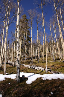
Apsens to the right of the trail. There is more moss than snow.

Around 0.5 miles beyond the South Chicago Creek trailhead, the road seemed to dead end in a small meadow. I could see what looked like a trail heading off to the right with a steep ascent. I followed this for short distance until I could no longer follow any trail. There were aspens everywhere and while it would have taken some effort to get lost, particularly with snowshoe tracks, I decided my fun meter was pegged, and I turned around. Later I studied a topo map of the region and saw that from the trailhead junction, the trail/road continues on quite a distance in a large sweeping arch to the north.

The open meadow that might make a more obvious turn around point.

Because of the conditions at the trailhead, I had left my snowshoes in the car and had headed up with just Yak Traks. That was a mistake. While the snow was packed down, it had been driven by a vehicle, so it was rutted, soft, and slippery. Snowshoes, while not technically necessary would have made the going easier.

I followed the trail until it led into these trees.

This snowshoe is not filled with spectacular views but it is open, filled with solitude, and accessible to dogs. Sometimes braving the I-70 traffic is just not feasible. When this is the case, consider Hefferman Gulch. This year the snow on the eastern side of the Divide has been sparse. In other years, it has been impassible. A good snow year would make this trip even more enjoyable.

A frozen Echo Lake

Echo Lake is 4 miles farther up Hwy 103. I drove up there to admire the view and to each my lunch. On a nice fall day, Echo Lake is a pleasant destination for a family picnic. There are tables, bathrooms, and an easy trail around the perimeter. For views farther up, check out my post on Mt. Evan’s Summit Lake.

North Rock Creek Snowshoe

Distance: 4 miles round trip Elevation: 9,180 ft to 9,780 ft Elevation Gain: 600 ft Dogs: Off leash until the wilderness boundary North...