Saturday, September 6, 2008

Summit Lake (Mt. Evans)

Distance: 300ft to 0.25 mile
Elevation: 12,830 ft
Elevation Gain: Negligible


Summit Lake on Mt. Evans

Two years ago, my hiking buddy twisted her ankle and we were moping about wishing we could get into the high country. Alas, we live in Colorado and it dawned us that we could get there the easy way, by driving. I would have much rather have hiked to Summit Lake but what’s a girl to do with her foot in a boot?


View on the drive up to the lake

The road up Mt. Evans is scenic at every turn. Be prepared, however, to pay the $10 fee that the forest service has initiated. I have a friend who is a Ranger on Mt. Evans and he has told me that people are rebelling against this fee and are refusing to pay, saying that they won’t get out of the car. Don’t bother playing this game. You are going to want to get out of the car and a $10 fee is a small price to pay for the extraordinary views that await you.


View of Chicago Basin from the far end of the lake

The lake is only a few hundred feet from the parking lot…easily doable in a boot. We even ventured to the far end of the lake (0.25 miles) to the Chicago Lakes Basin. This view is worth strolling to and if my friend the Iron Maiden can make it, then you certainly have no excuse.


Rocks and peaks from the lake

Be sure to admire the summit of Mt. Evans and Mt. Spaulding that surround the lake and imagine yourself slogging to the summit the old fashioned way.

Wednesday, September 3, 2008

Thunder Lake Hike

Distance: 13.6 miles round trip via Ouzel Falls or 12.2 miles round trip via the fire trail
Elevation: 8,500 ft -10,574 ft
Elevation Gain: 2,074 ft net, 2,318 ft cumulative

Thunder Lake

I confess that I was trepidatious about hiking to Thunder Lake in Rocky Mountain National Park. Ten miles with a heavy pack and stiff boots is a haul. 14 miles seemed overwhelming. On top of that, I was mobilized with the National Guard for the two weeks prior in support of the Democratic National Convention. I worked nights and did not get a chance to exercise. Not what I prefer to do before a death march.

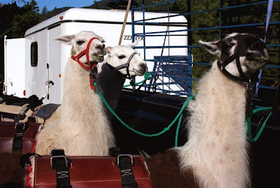
Getting the Llamas ready to go

My friends saved me, however, by bringing Llamas along to carry a huge potluck lunch and all our gear. All I had to do was carry one liter of water and my camera. I even wore lighter boots since I was carrying no weight. The trail itself is a gradual climb with only a few short stints of quad busting effort. By the end, the distance did not seem so bad, which tells you how much pack weight affects the body.

View of the trail

Thunder Lake is a pretty destination that everyone should do at least once. It is surrounded on two sides by crenelated ridges and on the other two sides by large grassy meadows. The downside of the lake, however is that there is no place to sit and lounge near the lake itself. You can walk down to the shoreline and bushwhack through the shrubbery to view the lake but there is no place to sit. We ended up having our party on the porch of the backcountry cabin that looks out onto one of the meadows.

Stream along the trail

Llamas crossing a stream

There are two routes you can take to Thunder Lake, both start in the Wild Basin side of Rocky Mountain National Park. The most common route takes you by the Calypso Cascades and Ouzel Falls. While adding some variety, it is also 0.7 miles longer. On this trip we chose to take the fire trail by pass instead. This trail is steeper and rockier but also shorter. We did this not only to save mileage on the long hike, but also to minimize pedestrian traffic for the Llamas. Be advised that this route is in the trees the entire time with only occasional brief glimpses to the south of Meadow Mountain (11,634 ft) and St. Vrain Mountain (11,391 ft). The views do get better for the last two miles with occasional stream crossings to lighten the mood.

Farther along the trail

The ranger cabin with the lake in the background

If you have not been to Wild Basin in a while, you will notice that the National Park Service has improved the parking situation. In addition to more parking slots, there was a small army of volunteers telling you precisely where to park. The lot, while large, does fill up by 9:30 on the weekends so get there early if you want a spot.

Thunder Lake

Meadow as seen from the cabin

Despite a forecast with a low probability of rain, it rained the entire way back to the car. My Marmot raincoat leaked like a sieve and I was soaked through. This is my second rain jacket. The other one, an REI brand also leaked badly. My friends did believe when I say this happens. Am I cursed or have others run into leaky jackets? For several hundred dollars, I expect more.


The right side of the lake

Traveling with Llamas was a hoot. Each one has a unique personality and facial expressions. I enjoyed watching their feet as they walked. They have soft pads on the bottom of their feet, which makes them ideal wilderness packers. Their impact is less than a hiking boot and their hooves are so small that they are comical in appearance. They would hum when not together as if whining for their buddies. As members of the camel family, they don’t drink much water and did not eat the grain that was brought along for them. They can carry a third of their body weight, roughly 50-75 pounds, and will literally crawl into your minivan. The gal who owned these Llamas does not own a commercial business but loans them out to the Forest Service. If you find a commercial outfitter, they run about $50/day per Llama.

Saturday, August 23, 2008

Go John Trail: Cave Creek Recreation Area, AZ

Distance: 5.8 miles
Elevation: 2,200-2,500 ft
Elevation Gain: 300 ft
Critters: Rattlesnakes


A view looking east along the Go John trail

A couple of years ago I was laid off from my job so I blew some of my severance money and flew down to Arizona to lounge at a spa. Nearby was the Cave Creek Recreation Area. I rented a car and drove the short 10 miles to the trailhead. This was March, and the Sonoran desert was in full bloom. Besides wildflowers, March is mild with warm days and cool nights. Given that Colorado is often still snowy at this time of year, a jaunt down to Phoenix for some early wildflower gawking is not a bad idea. Toss in the spa and you have a nifty stress-relieving getaway. I am not sure what Phoenix has more of, cacti, golf courses, or spas. Surely, you can find one that meets your needs.


The first hill

This trail is a loop that will take you around some large rock formations as well as out into the desert expanses. The trail starts in the picnic area and starts out on a wide path that quickly narrows. There is a sharp ascent towards a picturesque saddle. From its “lofty” heights you have views to the south. From here the trail descends sharply and begins to meander through rolling hills and gullies. It will eventually circle back to where you began. There are a couple of off shoots, so if a trail map is available, bring one along so you don’t go traipsing off into the desert never to return. Sunscreen, a broad brimmed hat, and plenty of water are required for any desert hike.


Saguaro Cactus and flowers

The dominant floral species are Teddy-bear Cholla (Cylindropuntia bigelovii) and Saguaro Cactus (Carnegiea gigantean). These hardy desert dwellers make a wonderful tableau of shapes and sizes. Combine this with radiant blue skies and the eye-popping colors of the seasonal flowers and you have a photographers dream. Only the intense sunlight ruins this combination. If possible, head out at sunrise. I never manage to get out of bed that early but all the great photographers do.


The trail just after cresting the first hill

No matter where you go on travel, there is likely a trail nearby to explore. Expanding one’s horizons to include non-alpine zones is well worth the effort. Next time you are in Phoenix give this trail a try.


California Poppies

Ireland: Rock of Cashel

Looking up at Cashel and it defensible position


No trip to Ireland is complete without a stop at this unique ruin. A complex of fortresses and cathedrals, it is a hodgepodge of architecture covering many millennia. Home to king and bishop, it contains ruins, palaces, and a wonderful Celtic cross cemetery. It is located in County Tipperary in the south-central part of Ireland.

The round tower


The buildings sit atop a large upthrust of granite with dramatic views of the surrounding plain. It is easy to see why every noble and his brother wanted to live and defend the rock. It is the only high ground around. Unlike today’s interlopers, they did not scrape and rebuild but continually added on so that what remains is a tangle of grey stone only a tour guide can unravel.

The join between Cormac and the Cathedral


I confess I wandered about snapping pictures without a clear appreciation for what I was looking at. I just like ruins. Their antiquity reminds me how far we have come while at the same time their decay reminds me of the fleetingness of power, religious dogma, and wealth. The wonders of the Internet, however, will allow me to describe a few of the features.

Exterior of the Cathedral


Interior of the Cathedral


The 90 ft round tower, the oldest building and dates from 1100. The next oldest is the Chapel of King Cormac, which dates from 1134. This building stands out because its stone is a Rufus brown while the other buildings are slate gray. Still, it easy to miss this chapel since it dwarfed by the Cathedral built in 1270.

Celtic cross cemetery


Standing in this structure one senses the awe the common peasant must have gained by struggling to the top of this promontory and standing within the lofty environs of its sanctuary. Surely such a place would have felt divinely inspired. A brightening of the gray, dull existence of those whose only joy was the thought that heaven promised a better life. The crumbling stone and moss covered crosses tell a different, more painful story. All is dust and inconsequence. Had they known, would they have treated their overlords differently?

Another exterior view


Coming from Colorado, I could not help but enjoy the views of the surrounding plains. There are several younger ruins scattered about within cannon shot but there did not seem to be a way to get there. They stand out starkly against the sweet meadow grasses that are slowly reclaiming the ground on a scale invisible to the human eye.

Other posts from my trip to Ireland:

Saturday, August 16, 2008

Ireland: Dingle Peninsula

Tags: #travel, #ireland
Other Posts: NewgrangeRock of Cashel


The colorful boats and buildings of Dingle Ireland
The Dingle Peninsula in southwestern Ireland is a stark place where an unforgiving sea meets an unforgiving land. When the English ruled Ireland, they banished the locals to this zone of harsh and magnificent contrasts. Through tenacity and grit they managed to eke out a living by laboriously dragging sand and seaweed up onto the barren hillsides until they could at least farm the nefarious potato.

Sheep along the coast of Dingle Bay
Dingle coast
In April of 2005, I took my father to Ireland and we stayed in Dingle and drove its narrow byways. I don’t know who was more frightened, my father in the passenger seat or I in the drivers. My side of the very narrow road was bordered by the ubiquitous stone walls while on my father’s side there was the ever present trucks that have invaded this narrow world where traditional Ireland still reigns. A lot of screaming went on in our little car as each of us looked out our respective windows at imminent death.

Rugged coastline
How green the hills
The town of Dingle is a pleasant fishing village, colorful, and friendly. There are pubs, decent restaurants, and lots of salt air to refresh the senses. It was also significantly warmer than Dublin for which I was immensely grateful. You would think someone so intimately familiar with layering as I would have packed better, but I left my down jacket at home. I was more worried about rain and so I dragged along a softshell instead. This was a mistake. I had forgotten how chilly a damp climate can be even when the mercury reads a moderate number.

Blasket Island in the sun
This reminiscence is the result of watching an episode of Rick Steve’s Europe. I opened up the folder on Ireland and started poking through the photographs. Too much time has passed and too little booking keeping has prevented me from labeling each of these with their precise location. Most were taken along at the far edge of R559 between Glanfahan and Dunquin. Hopefully, they will give you a general sense of the area. The island off shore is the Great Blasket Island. Even harsher than the mainland, the government forcibly removed the residents back in the 50s. You can take a boat out to see the ruins, but we did not do this.

Blasket Islands in clouds
As with most travel, it is impossible to see everything in a short 10-day vacation and I regret not exploring up the coast towards Gallway. My father is not a hiker, either, so I will just have to consider returning to the area so I can stroll over the verdant hills. The rocky trails of Colorado should adequately prepare me for the conditions! If the topography of western Ireland appeals to you, I would consider flying into Shannon and staying on that coast. There is much to see.

Here are some links to great travel guides to Ireland. Buy from Amazon and I will get a small commission.


Friday, August 15, 2008

Durango to Silverton Railroad


The train stops in several scenic spots so you can photograph the train itself.

It is August 16th and the high today is only 50 degrees so I can’t help but think of Fall and my trip to Ouray two Septembers ago. I flew my parents out and my mother and I rode the Durango and Silverton Railroad one way to Silverton. This is another one of those quintessential Colorado experiences. Fall is a great time to ride the train because there are spots of showy aspens all along the route. Dress warmly though if you go this time of year. While the coaches are enclosed, the gondolas are open air and at times I was wearing three layers, gloves, and a warm hat. A thermos of hot chocolate will make the trip even better. Seats are assigned so you have to choose your car before hand.


Rocks along the Animas

The D&SNGRR, which stands for the Durango & Silverton Narrow Gauge Railroad, was completed in 1882 and was initially used to haul silver and gold out of the mountains. Narrow gauge rails, which are three feet apart, are easier to lay around tight mountain curves. You will see on the route that there are some tight curves indeed! Interestingly, standard rail gauge is 56.5 inches, which was the width of Roman chariots. Now that is a standard worth keeping. And I thought the English foot (12 inches) was a bad measurement!

We stayed in Durango the night before our trip and it poured like it is today, which is probably why I am reminiscing. Since the train departs at 8:15 AM, this was not a bad choice. We were fortunate to have my father pick us up in Silverton because at 18 mph, the train trip takes 3.5 hours. Going back would have been too tedious for me. There is a motor coach option at certain times of the year, however, and I would recommend that for the variety if nothing else.


It is hard to identify milestones along the route but you can google the animas river since it tracks this pretty well. At times the train is right along side the river bed and at other times it is high above with the Animas rushing through a sculpted gorge below.


My favorite photo from the trip. You can sense the change in the seasons between the snow, color, and low hanging clouds.

The D&SNGRR is a history lesson, a kitschy tourist trap, and a wonderful way to see some stunning Colorado scenery all rolled into one. For train buffs this is an absolute must. Everyone else should do it too. Just get your tickets well in advance. Prime time fills up quickly.

Thursday, August 14, 2008

King's Crown


Mature King's Crown

King's crown has two scientific names, Rhodiola integrifolia and Sedum rosea. This benefits a plant that thrives in both moist meadows and dry open areas. This specimen was found near a stream along Mayflower Gulch.You can recognize it by its short, succulent leaves that grow upwards in a tight column. It grows in sub-alpine to alpine environments.


Young King's Crown. Note the succulent leaves.

Quandary Peak

Distance: 6.75 miles round trip
Elevation: 10,850-14,265 ft
Elevation Gain: 3,450 ft
Dogs: Off leash
Bathroom at Trailhead: No
Date Hiked: 12 August 2008
Tags: #14er, #peak, #mountainpeak, #Breckenridge

Quandary Peak (14,265 ft) viewed from the East Ridge
Quandary Peak near Breckenridge, CO is technically one of the easier 14ers. There is no large talus dome at the top to navigate and minimal exposure. There are also large rock steps placed frequently along the route so that at times it may feel like Stairmaster instead of a mountain. There is, however, a lot of loose skree that will make coming down a chore. Quandary Peak is also known for its numerous false summits.

The lower part of the trail is in the trees.
The elevation gain on Quandary is nothing to laugh at, but given a nice day without pressure from the weather, anyone who has either exercised regularly or who is very determined can achieve the summit.

Quandary Peak look like a giant snowboard ramp. The route stays to the sides of this ramp or ridge rather than ascend directly up the middle of it. Because of this, the views are spectacular the entire way.

Northstar Mountain viewed from the left side of Quandary's ridge
The trail to the summit is low enough that it begins in the trees. It takes you to the right, northern side of the ridge (McCullough Gulch), but then quickly winds back towards the southern side (Monti Cristo Gulch) where it will stay for the rest of the journey.

Monte Cristo Gulch and Blue Lakes
Around 12,000 ft, Blue Lakes deep in Monte Cristo Gulch come into view. This gulch is bordered to the south by a jagged ridge line that joins North Star Mountain to the east and Wheeler Mountain to the west. The dam at the end of the Gulch is the starting point for the West Ridge route up Quandary. This route is much more exposed and should only be attempted by more experienced climbers. At the time of this posting, renowned chef from Missouri died on this route another climber nearly died after a horrible tumble down the Monte Cristo couloir.

Summit viewed from the left
Heading up to the ridge at 13,150 ft
Quandary Peak is unique in that you can see the summit and much of the route from a road that many people travel getting to and from Breckenridge. The sharp rise in the "ramp" is clearly visible and looks enormous.  From its base the summit is only one mile and 1,100 ft of elevation gain away. The trail in this area is still mostly skree but is occasionally dirt. It is here that the false summits begin.

On the East Ridge, a little farther up
On the narrow portion of the ridge
Each succeeding pile of scree blocks the upper portions of the ridge and gives the illusion that it will be the last. Alas, you will be able to see the last pile and the summit just off to the left so until you do, don’t be fooled.

First large scree pile on the upper 1,000 ft
The last false summit
There is no large boulder field at the top of Quandary Peak. The top can be strolled across with ease. The views to the west are by far the most dramatic. Mount of the Holy Cross and Notch Top Mountain can be clearly seen to the west. Closer in, just across the West Ridge is the Fletcher Mountain and the backside of Mayflower Gulch. To the north is the cone-shaped Crystal Peak. To the south is Mt. Democrat, Mt. Lincoln, and Mt. Bross, and can even see some of the trails that connect these three.

The summit is in sight.
The journey down from the summit can be an exercise in drudgery. Loose rock requires more concentration than you would image. A joyous strain may just fill your heart upon reaching terra firma.

View from the summit looking northwest towards Crystal Peak
View from the summit looking at a hiker coming up the West Ridge
Back down, looking at the green hills of Summit County
Hiking to the summit of Quandary Peak will give you a fantastic sense of accomplishment and a great calf workout. It is close to Denver however, so expect crowds.

The trailhead to Quandary Peak is accessible via a normal passenger car. From Breckenridge, drive 8 miles south on CO Highway 9. Turn right (west) on the 850 (Blue Lakes) Road. Drive a few hundred yards and turn right on the 851 (McCullough Gulch) Road. Drive 0.1 mile to the signed trailhead and small parking area.

North Rock Creek Snowshoe

Distance: 4 miles round trip Elevation: 9,180 ft to 9,780 ft Elevation Gain: 600 ft Dogs: Off leash until the wilderness boundary North...