Distance: 8.7 mile loop (7.7 without the Windy Peak add on)
Elevation: 7,646 ft - 9,106 ft (at Windy Peak)
Elevation Gain: 1,460 ft (net) 2,164 ft (cumulative)
Date Hiked: 12 June, 2011
Dogs: On leash only (State Park)
Tags: #coloradostatepark, #goldengatecanyon
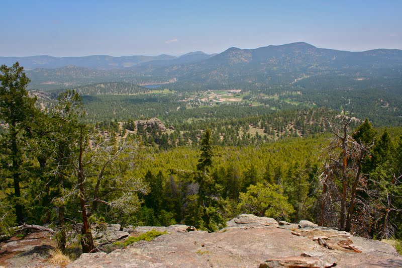
 The view of Mt. Evans from Windy Peak and the Mountain Lion Trail in Golden Gate Canyon State Park
The Mountain Lion Loop in Golden Gate Canyon State Park near Golden, CO is harder than it looks, but the extra exercise is rewarded by a journey through three different ecosystems, and if you tack on a diversion to the top of Windy Peak (adds an extra mile), some stellar views of the Continental Divide.
 Trails are marked with animal track symbols in Golden Gate Canyon State Park and appear on poles such as this. Junctions are well marked with wooden signs and full maps indicating where the hiker is located.
 Heading up the initial dry hillside. Most of this route is on soft dirt.
The confusing part of Golden Gate Canyon State Park is the plethora of trailheads, which are really nothing more than pullouts on the side of the road. There are at least three along County Rd 57 (right at the Visitor's Center) that label themselves as Mountain Lion Trail trailheads and none have rest rooms, so plan accordingly. If you find the trailhead on Nott Creek Rd, there is a bathroom and plenty of parking. This is probably the best place to start.
 The initial ridge
I traveled the loop in a clockwise direction. Since the hot side of the loop is to the left and the cool Riparian side is to the right, this was a good choice on a hot day. I don't know how the cumulative elevation gain differs if you take the route in a counter-clockwise direction but the net elevation is the same since the destination is Windy Peak no matter which way you travel.
 The lake and cabin in Forgotten Valley. Camping is permitted here.
Taken clockwise, the trail heads across an open hillside filled with wildflowers and dotted with Ponderosa Pine. It climbs 443 ft in less than a mile, so it will get your heart rate pumping early. After reaching a ridge at 0.89 miles, the route travels another 0.33 miles until it reaches the junction with the Burro Trail (at 1.23 miles) with the official split happening around 50 yards further up. At 1.97 miles is Forgotten Valley and a pleasant lake and cabin. The day was already getting uncomfortably warm, so I took this opportunity to rest in the shade, dunk my head in the water and wet my bandana.
 Leaving the lake and heading up the next valley
After the lake, the route heads up a long valley and then starts up a series of switch backs that gain 500 feet in 1.2 miles. The views of the rolling hills to the south is quite pleasant and would be lovely in the fall when all the leaves are turning. At the top is a saddle (at 3.18 miles) deep in a grove of Lodgepole Pines.
 Three quarters of the way up the switchbacks on the way to Windy Peak and looking back down the valley to the tree covered hills deep within the park.
From this point the trail heads sharply downward and looses at least 190 feet before the intersection with the Windy Peak spur at 3.3 miles. From this point it is 0.5 miles to the Peak, which is a series of rocky outcroppings, covered in lounging hikers and voracious
chipmunks who scurried to and fro hoping to steal a sandwich from an unsuspecting hand. I am not sure where all the hikers came from, because I was practically alone on my trip up. They may have come up the Burro Trail, which is a more direct route. At this point the cumulative elevation gain was 1,581 ft and I recorded an approximate elevation of 9,173 ft. An more official measurement may be 9,106 ft.
 Park of the short but steep trail up to Windy Peak.
The trip down from Windy Peak and to the rest of the Mountain Lion Trail is a long series of switchbacks through a Lodgepole forest. Finally, the route empties into a valley and closely follows the stream, crossing it at least a dozen times. The stream crossings are all on small log bridges. Some of these are in better condition than others. If you don't like narrow crossings, this is not the route for you. It became very tedious after a while.
 Hikers lounge on the summit of Windy Peak
 A close up of Mt. Evans from the summit
The valley narrows half way down and the walls and their many nooks and crannies encroach on the hiker making the area feel confined, scenic, and wild all at the same time. I confess that I started day dreaming about Mountain Lions in this stretch because there were a thousand places for a Mountain Lion to hang out and watch the trail. I found myself turning around periodically to gaze behind me to see if I was being followed. It did not help that I knew of someone who had been stalked by a Mountain Lion in Golden Gate Canyon State Park. It was not until I got through this section and finally ran into another hiker that my unease dissipated. Was this a sixth sense or mere lone hiker paranoia? I'll never know for sure.
 An example of the overgrown and wild Riparian side of the Mountain Lion Trail
Once the route leaves the stream, it climbs again up a broad road to reach the hillside that parallels County Rd 57. This was my least favorite part of the trail. I was overheated, tired, and did not want to ascend any more. From this point it was a seemingly long slog until I reached the trailhead at Nott Creek Rd (at 8.3 miles) and then had to travel an additional half mile to my car (at 8.7 miles).
 A photo of the most deteriorated stream crossing. I ended up taking the lowest log on the left, which was several feet lower than the others and used the other logs to brace myself as I crossed.
 Looking back up the route after regaining the hillside. I believe the route comes down the left cleft on the distant hillside.
Despite the length, I really liked this hike. It was so varied that it was impossible to get bored. I chose to do it on a very hot day and only had 1.5 litres of water with me. I chose this amount partially because the park advertises this loop at 6.2 miles. My GPS recorded it as 8.7 miles, including the add on to Windy Peak. Had I known this in advance, I would have carried more. Water weighs a lot and I have gotten in the habit of carrying just enough.
 Continuing along the final stretch to the trailhead at Nott Creek
This Colorado State Park is a pleasant oasis close to Denver and yet worlds away. The drive to the park itself is scenic and the many trails in the park allow for varied adventures of all levels and for all sorts of visitors. Check it out if you get the chance.
 The views of the hills to the east from the final stretch. This hike was pleasant indeed.
 An attractive example of the Utah Juniper from Paradox Valley, CO.
 The distributed pattern of the Utah Juniper seen from the Dolores River Canyon Trail.
 A close up of the needles and berries
 The view of Mt. Evans from Windy Peak and the Mountain Lion Trail in Golden Gate Canyon State Park
 Trails are marked with animal track symbols in Golden Gate Canyon State Park and appear on poles such as this. Junctions are well marked with wooden signs and full maps indicating where the hiker is located.
 Heading up the initial dry hillside. Most of this route is on soft dirt.
 The initial ridge
 The lake and cabin in Forgotten Valley. Camping is permitted here.
 Leaving the lake and heading up the next valley
 Three quarters of the way up the switchbacks on the way to Windy Peak and looking back down the valley to the tree covered hills deep within the park.
 Park of the short but steep trail up to Windy Peak.
 Hikers lounge on the summit of Windy Peak
 A close up of Mt. Evans from the summit
 An example of the overgrown and wild Riparian side of the Mountain Lion Trail
 A photo of the most deteriorated stream crossing. I ended up taking the lowest log on the left, which was several feet lower than the others and used the other logs to brace myself as I crossed.
 Looking back up the route after regaining the hillside. I believe the route comes down the left cleft on the distant hillside.
 Continuing along the final stretch to the trailhead at Nott Creek
 The views of the hills to the east from the final stretch. This hike was pleasant indeed.
 This Common Collared Lizard (Crotaphytus collaris) let us walk right up to it and shove a camera in its face on the Dolores River Canyon Trail.


 Sagebrush (Artemisia tridentata) blankets much of the state. This example is from the Dolores River Canyon.
 A close up of the leaves. Sagebrush is a popular color in western motifs.
 The scenic Dolores River travels over 500 miles through Colorado, cutting canyons as it goes. The hike out of Bedrock, CO is an easy way to explore this unique topography.
 Looking up the canyon from where we parked at 38°17.742/108°53.884. The first cliff in the distance is the sharp right turn that is 0.87 miles way.
 Looking back up the road we drove down toward the entrance to the canyon. The cliffs bordering the northern end of the Paradox Valley are clearly visible in the distance.
 The flow within the Dolores River is controlled upstream by a dam. Usually just a trickle, the authorities release water at certain times of the year for agriculture and rafting.
 We have just made the sharp right turn at 0.87 and are heading further up the canyon. The slot in the center of the picture is our destination.
 The geology of the area is the primary appeal. Ancient sand dunes and river beds form sequential layers of various colored rocks of Triassic and Jurassic periods. The most prominent is the Wingate Formation, formed from dunes around 200 million years ago.
  Near the deep stream bed that is reach at 2.0 miles, the ground was filled with layers that were obvious ancient mud beds, which give it this purple color. This part of the trail was littered with bright teal fragments.
 Looking down into the dry stream bed with its many layers of rocks. Just a few weeks prior to this hike, I hiked to Linville Falls in North Carolina. There I saw similar geology but active water. The contrast was startling.
 The trail is close to the river at times and further away at others.
 Near the end of the trail, is a large series of boulders that obviously fell from the side of the cliff. Some are upright (e.g. layers are parallel to the ground) and some are on their sides (layers exposed). The one containing the petroglyphs was quite obvious. It is close to the trail and there is a large National Park Service sign pointing them out. What we did not find was the dinosaur tracks that are supposedly on the back side of on of the boulders that is on its side.
 It was hard to pick a picture that typifies the cliffs in the area. The reality they surround you on both side and hog the distances.
 The view looking up Le Sal Creek. You can see the trail fading off into the distance.
 Topo map of the area. Hwy 90 is visible in the upper right and the Le Sal Creek in the lower left. The sharp 90° turn is noticeable where the river passes close to a sharp point in the relief. The scale and varied nature of the cliffs is also discernible form the map.
  A pair of Plateau Lizards on the side of a B&B in Paradox Valley
 Am I being anthropomorphic, but does the female have a bit of a gazed look in her eye, or is it just resignation?

