Distance: 3 miles round trip
Elevation: 5,560 ft - 6,393 ft
Elevation Gain: 880 ft
Bathroom at Trailhead: No
Dogs: Not allowed at all
Date Hiked: 1 April 2012
Tags: #Boulder, #osmp, #hiking, #coloradooutdoors
 |
| Heading up to the Hogback on the Hogback Trail north of Boulder |
The Hogback lollypop trail, just north of Boulder, is an unassuming jaunt across open grassland and up the steep slope of the first foothill of the Front Range. Its name is derived from the large outcropping of rocks known as the Hogback, that are the apex of the route. Since dogs are not allowed on this trail at all, this is only the second time I have hiked it. If you don't care about Fido, however, this trail has sufficient elevation gain to classify as great shoulder season training hike. It is rarely impassible but its exposure and lack of shade would make for a toasty outing in summer.
 |
| The Hogback Trail starts at the Foothills Trailhead, just north of Boulder |
 |
| The Trailhead. That is a tunnel under Hwy 36 a 100 yards in the distance |
 |
| The winding first 0.5 miles of the trail |
 |
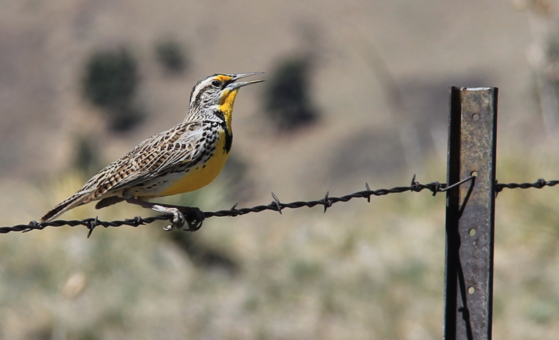
| The bright yellow breast and distinctive song of the Meadowlark accompany the hiker on the Hogback Trail. |
The initial part of the trail traverses a small valley filled with
Prairie Dogs and
Meadowlarks, who brazenly yoddle from every fence post and stalk of Yucca. At 0.5 miles the trail intersects and merges with the Foothills Trail and then splits off at 0.65 miles to the Hogback Trail. A short distance beyond this is another T-junction that represents both sides of the Hogback Loop. I prefer to ascend via the left. From this vantage, there are lovely views of the Flatirons and the ascent to the Hogback itself traverses a hidden plateau that for at least a few minutes makes you forget you are near the city.
 |
| The intersection of the Foothills Trail and the Hogback Loop |
 |
| The junction of the loop itself. Take the left fork for a harder and more scenic climb. |
 |
| Looking out onto the plains and back down on the parking lot 600 feet below |
 |
| The steepest section of trail has improved stairs. |
It is 1.5 miles to the middle of the Hogback formation itself. The trail stays below the edge, so if you want views you'll have to do a little rock scrambling. Just be on the lookout for Rattlesnakes lounging in the nooks and crannies.
 |
| Looking up at the Hogback from the south |
 |
| This brief but pleasant segment winds through rocks and Ponderosa Pine |
 |
| An exposed section of rock below the summit |
 |
| Walking below the summit of the Hogback ridge |
For you geology buffs, a Hogback formation gets its name from its resemblance to the bristled spines of a wild hog. These formations occur where erosion has revealed the sharp rocks of a tilted or uplifted rock formation. Hogbacks can be seen up and down the Front Range. The most famous one to the south, Dinosaur Ridge, has the preserved footprints of Sauropod and carnivorous dinosaurs.
 |
| Still on the ridge but starting to descend |
 |
| Looking down the decent |
 |
| Looking north from below the Hogback |
 |
| This herd of Mule Deer walked right up to me |
While the Hogback trail will not attract tourists from far and wide, it is still a pleasant outing, particularly if you live in Boulder and are sick of the trails around Chautauqua. I do suggest checking it out...just leave Fido at home.


2 comments:
my goodness your meadowlark is a lot zingier than ours, which is a drab wee bird - but with a beautiful song.
It must be amazing to see dinosaur footprints - less wonderful to come across a rattlesnake.
I have a Scottish mountain for your this week for you to compare trails.
Looks like a pleasant hike. Nice photos!
Post a Comment