Distance: 4 miles round trip
Elevation: 5,645ft – 6,300ft
Elevation Gain: 655ft
Date Hiked: 12/13/08
Dogs: Off leash in designated areas with Boulder green tag
Bathroom at Trailhead: Yes
 |
| The Dowdy-DeBacker-Dunn Homestead gives the Homestead trail its name. Frozen in place, its cold stones hold the memory of many Front Range winters. |
With yet another storm raging in the high country we once again set our sights on a lower hike along the Front Range. This loop near Boulder travels up the Homestead Trail for 1.1 miles, heads west along the Towhee Trail for 0.4 miles, then jogs 0.3 miles on Shadow Canyon before finishing up with 2.0 miles along the Mesa Trail. There is a web of trails at the southern end of the Mesa Trail, and hikers can choose many different options.
 |
| Map of the route |
 |
| The beginning of the trail. The homestead is just out of the picture to the left. |
 |
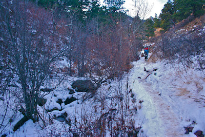
| Heading up the Homestead Trail |
The Homestead Trail is nice because it is a steeper and more strenuous ascent. It will get your heart rate going as you climb the many steps leading up to a broad plateau. From the top, there are views of the distant plains as well as the ever-approaching Flatirons.
 |
| View from the Homestead Plateau |
 |
| Snow on the back side of the Homestead Trail |
 |
| The Towee Trail is in a gully and the snow here was packed and slick. |
The Homestead trail descends back down the north side of the plateau to intersect with the Towhee Trail, which comes up the gully from the right. This (north) side of the plateau was still snow encrusted and very slick. The Towhee Trail also has the disadvantage of being a leash only, which is another good reason to start out on the Homestead Trail if you have dogs that need to run free.
 |
| Near the intersection of the Towhee and Shadow Canyon Trails |
 |
| View from the Shadow Canyon Trail |
 |
| Heading up the Mesa Trail |
From the Towhee Trail, the loop heads east on Shadow Canyon for just 0.4 miles. There are nice views of some rock formations near this intersection and nice views of the plains a few yards up the trail. The Mesa Trail stretches 6 miles south to north, and at the intersection of Shadow Canyon and the Mesa Trail the hiker has the choice of heading north for another 4 miles or heading south directly. We decided to head north and upwards but were turned around by very slick conditions within a quarter of a mile. Just past the ruins of an old cabin, we turned around and headed back to the trailhead. The southern portion of the Mesa Trail is a broad. It winds gracefully downwards with sweeping views of the plains. The willows along the trail are filled with birds in the spring and summer.
 |
| Heading back down the Mesa Trail as it curves southward |
 |
| Around half way back |
 |
| Looking across to the Dowdy Plateau. |
At the apex of the Homestead and Mesa Trails are the remains of the Dowdy-DeBacker-Dunn Homestead. Built in 1858, all that remains is the stone section, unique for its multi-sized slab construction. In its day, an irrigation canal ran through it, providing fresh running water…of a sort. It seems hard to imagine this popular trailhead as the deep frontier but long before Boulder was founded, hearty stock had been settling in what was then Arapaho Indian country. For some it was gold but for others if was land for both farming and ranching. The original settler, Dowdy, ran a gristmill.
 |
| Close up of the rock construction |
 |
| Crossing the stream at the trailhead. Even in winter it has a stark beauty. |
Colorado is filled with history and many of its trails are strewn with mining relics, the ruins of old cabins, and the ghosts of pioneers. Half the time we overlook these doorways into the past. Glued to our iPods and focused on cardiovascular performance, they simply fade from view. So, next time you hit the southern Mesa Trailhead, take a moment to examine what is left of the homestead and look around. Imagine living there over 100 years ago.


1 comment:
Beautiful hike! That dowdy debacker home must have been so beautiful back in the day! loved the rock detail.
Post a Comment