Monday, August 15, 2016

Two Elks National Recreation Trail - West Entrance

Distance: 5 miles round trip
Elevation: 8,140 ft - 8,839 ft
Elevation Gain: 699 (net), 980 ft (cumulative)
Bathroom at Trailhead: No
Dogs: Off leash
Caveats: Trail is closed after the first two miles May 1st to July 1st for Elk calving. There is a shooting range a quarter mile from the trailhead, which can be noisy.
Date Hiked: 3 July 2014
Tags: #hiking, #coloradooutdoors
Nearby hikes: Game Creek


Mount of the Holy Cross is visible from the Two Elks National Recreation Trail.
The Two Elks National Recreation Trail (NRT) near Vail Colorado is a 12 mile "short cut" between I-70 and Vail proper and Highway 24 south of Minturn. Going the entire length requires serious stamina, a car shuttle, or a mountain bike. On this trip, we were looking for a less rocky trail with minimal elevation gain since my hiking partner had broken her arm several weeks before and falling on it would not have been good despite the new hardware screwed into her bone. Two Elks turned out to be just perfect.

The parking area
The trail starts out on shaded side of the creek.
From the west side near Minturn, this trail ascends gradually along a soft dirt trail that parallels Two Elk Creek. The vegetation was so lush that I felt half-naked without a pith helmet and machete. The gulch through which the creek travels is surprisingly deep, and the trail weaves up and down, sometimes close to the water but often as not half-way up the hillside. This turned out to be problematic because the weather was hot and we wanted to dunk our bandanas in the stream to cool off. Even in places where the trail was at the level of the creek, it would have been a "Doctor Livingston I presume..." adventure to bushwhack the 10 feet to the stream.

Two Elk Creek is ever present but not always accessible.
Now on the sunny side of the creek
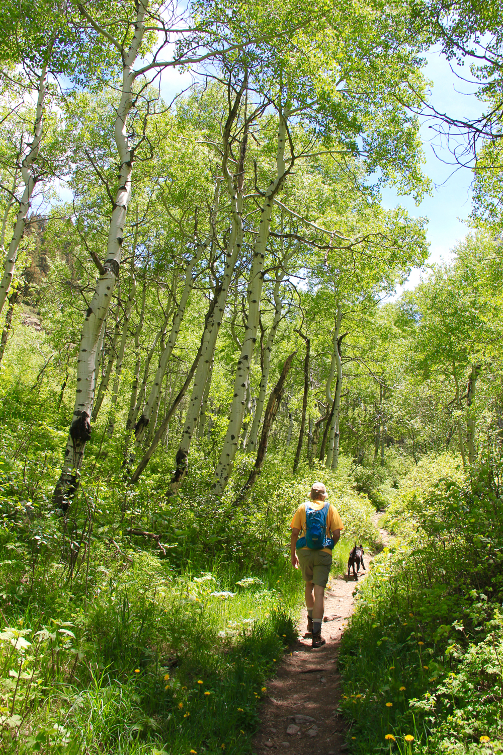
Because the gulch is oriented east/west, the vegetation is quite different depending upon which side of the creek you are on. The southern/north-facing side is filled with Douglas Fir and other shade-loving plants, while the northern/south-facing side is more open, filled with Aspen, green grasses and the occasional wildflower.

The trail alternates between treeless hillsides and thick foliage.
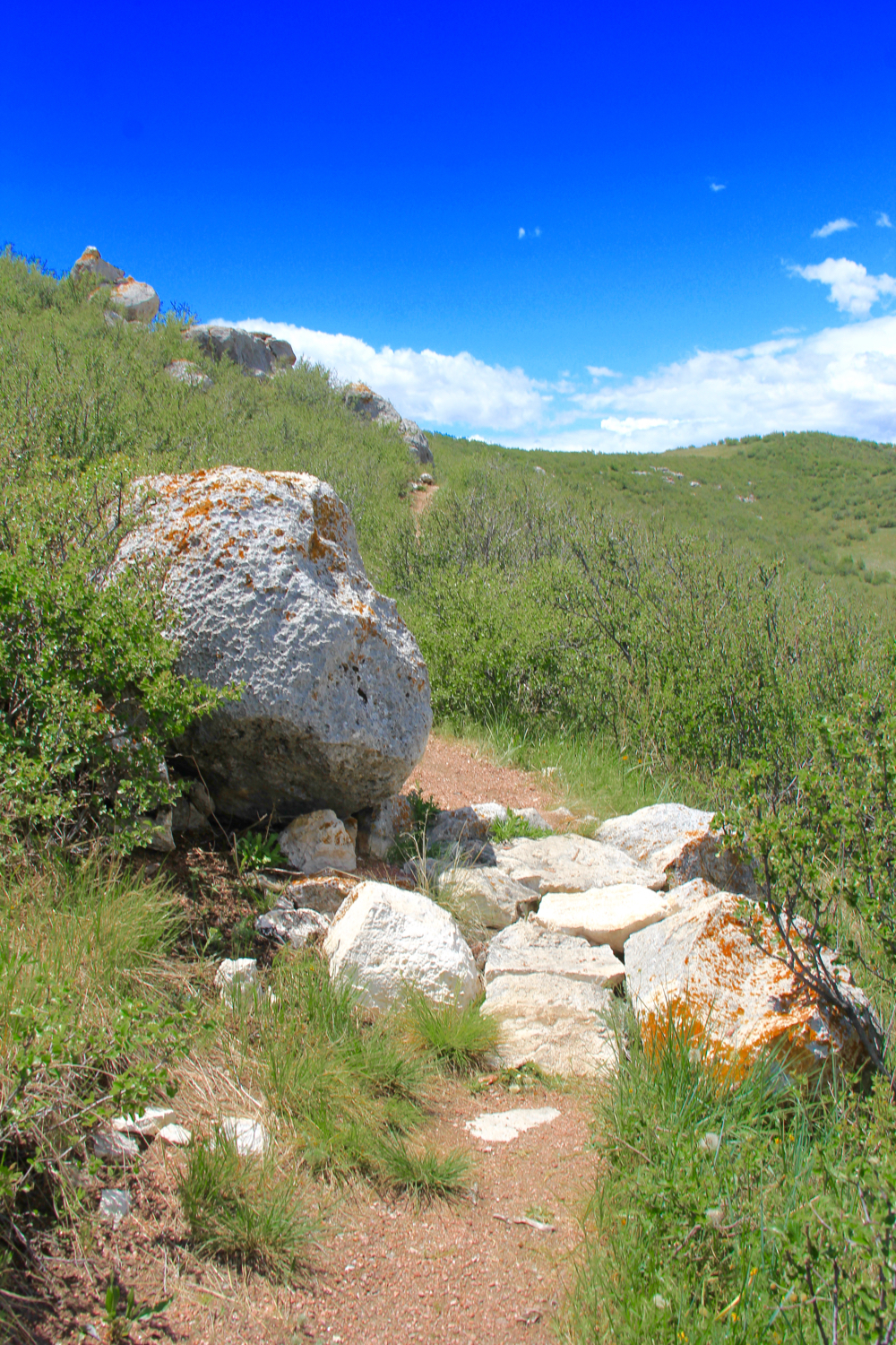
One of the more rare steeper segments
The higher you ascend, and on this trip we did not go that far, the better the views back down the valley. The famous Mount of the Holy Cross (14,009 ft) is framed nicely by the towering trees although the angle is just slightly off and the cross itself looks crooked.

Thick carpets of Boulder Raspberry covered the trail.
The most voluminous plant in the area was the Boulder Raspberry (Oreobatus deliciosus) otherwise known as Mountain Plover. While yellow in the fall, this plant is verdant green in the summer with white, ostentatious flowers. Individual plants can grow 3-5 ft tall and 6 ft wide and I think every single one of them had, they were so thick. This trail must be bear heaven in the fall in the with all the berries.

Another picture of the creek.
I have seen pictures of the trail much further up the gulch than we made it. The trees disappear and green grasses dominate. In our case, we turned around at 2.5 miles (851 ft cumulative gain) in a very pleasant stand of Aspen.

Boulder Raspberry encroach on the trail.
The Two Elks Trail is a find that I will add to my early season hiking list. In July it was too hot, but I bet in late May or June it would be sublime. Be advised, because of its length, you are more likely to run into mountain bikers than hikers. The ones we did run into were generally courteous and were NOT racing down the narrow track like they were being chased by wolves. A novelty to be sure!

The pleasant glade of Aspens that was our turn around point. Because of the thick undergrowth, there were not many places to sit.
To get to the west entrance of the Two Elks Trail from Vail, take I-70 west to exit 171 (Hwy 24) and head south. Go approximately 2.7 miles to Minturn and Cemetery Road (marked with just a typical green street sign). Turn left and cross the bridge.  Follow Cemetery Road until it crosses the railroad tracks (you'll see the cemetery at that point).  From the cemetery, continue on the road and turn right at the first fork (a single lane dirt road...rough put passible with a low clearance 2WD) and left at the second fork. You'll be weaving up and down the hillside paralleling the railroad tracks. Just before the trailhead, you pass a series of shooting ranges. They were occupied, and we did hear gun fire for the first half mile or so of the hike despite the roaring sound of the Two Elk Creek.

Tuesday, August 9, 2016

Meadow Mountain

Distance: 7.3 miles round trip
Elevation: 8,940 ft - 11,632 ft
Elevation Gain: 2,692 ft
Bathroom at Trailhead: No
Dogs: On leash
Date Hiked: 20 August 2015
CMC Rating: Easy C
HashTags: #peakbagging #coloradooutdoors #rmnp #tundra, #gearguide


View of St. Vrain Mountain from the slopes of Meadow Mountain
Meadow Mountain, near Allenspark Colorado, is an 11,632 ft peak sandwiched between the Indian Peaks Wilderness and Rocky Mountain National Park. The trail is a rocky slog that is more fatiguing than the distance and elevation gain would warrant but the views of Long's Peak from the summit are stunning so everyone should make the trip at least once.

Parking lot and trailhead
A typical trail segment, very rocky
View back down the valley
The trail to Meadow Mountain starts at the St. Vrain Trailhead. To get there, take County Road 107 (Ski Hill Road) out of Allenspark for 1.5 miles and then turn right on Forest Service Road 116 for 0.5 miles. Both roads are dirt. FSR 116 is getting eroded and while still passable with a passenger car, some zigzagging is required to find the least objectionable route.

Finally getting above treeline. Looking at an unnamed peak to the south.
Heading to the saddle. That is St. Vrain Mountain in the distance.
Looking up at Meadow Mountain from the saddle
The bulk of the trail is pretty much the same. It travels through Aspen, Spruce, and Limber Pine, making several sharp switch backs further up the valley. At 0.7 miles is the wilderness boundary, and at 1.9 miles is a small stream crossing. At 2.5 miles the trail finally breaks above treeline. The saddle is located at 3.3 miles (11,198 ft/1,844 ft elevation gain). Head to the left to continue on to St. Vrain Mountain or turn right and summit Meadow Mountain.

Heading up to the summit with hazy Indian Peaks in the distance
Approaching the summit
Long's Peak from the summit
The views from the saddle are stunning. St. Vrain Peak lies to the south while to the west is Wild Basin area of Rocky Mountain National Park. The hike up to the summit is not as difficult as it looks. Fifty percent of it is mostly tundra. The other half is a large talus pile. I had to put my camera away to scramble over some of the larger rocks. There is no preferred way to the summit. Some drift to the right others go straight up.

Weather station
Rock Shelter
On the summit
The summit is big enough to hold a high-school football game. There is a small solar powered weather station and a rock shelter. The latter really comes in handy when the winds start to blow. On this trip, the area was filled with smoke from the western wildfires and the peaks were obscured in haze.

Heading down

Monday, August 8, 2016

Game Creek

Distance: 6.6 miles round trip to meadow with view, 7.5 miles round trip to picnic table
Elevation: 8,005 ft - 9,917 ft (meadow) 10,077 ft (picnic table)
Elevation Gain: 1,904 to meadow, 2,157 ft to picnic table
Dogs: Off Leash
Bathroom at Trailhead: No
Tags: #hiking, #coloradooutdoors, #fallcolor, #vail
Other hikes in area: Two Elks Recreation Trail


Game Creek near Minturn, CO is an Aspen covered dream. 
Game Creek near Vail and Minturn, CO is moderate hike through a never ending Aspen grove to a lofty ridge with killer views of Mount of the Holy Cross. Game Creek itself roars in the spring providing easy access to cooling waters when temperatures soar. This lesser known hike is also one of only two places in Colorado I have seen Red Columbine. 

Parking area
Trail starts up this spur road between some houses
Red Columbine
The Game Creek Trail starts out next to a home and quickly climbs uphill to a small shelf skirting private property. Strings of rope and surveyors tape admonish the hiker to stay way from their land. Once past this property, the trail dips back down to the valley floor and crosses the creek at a small bridge.  From this point on it travels up the valley, keeping Game Creek on the right. There are several places where you can walk right up to the water and others where it is several hundred feet below.

Lower part of the trail is lush and hot in the spring. 
A more open area
The creek is further below here.
This trail will give your cardiovascular system a workout. It gains around 670 ft in 1.2 miles and 1,000 ft in 2.0 miles. If you hike it in the spring, it may feel more like a tropical jungle than a hike in the mountains. The vegetation is that lush. On the south side of the creek, towering Engleman Spruce dominate.

Towering spruce
Another Aspen grove
Some milestones along the way include the junction with the Cougar Trail at 0.6 miles and the sharp turn to the left at 2.3 miles. At 3.3 miles, which is up on the ridge,  is an open meadow with views of Mt. of the Holy Cross. This is a great place to stop and have lunch. The trail does continue for another half mile to an old picnic table.  This latter bit is only necessary if you are looking for extra mileage. The views don't improve much.

After the turn the Aspen continue
View from the ridge
You get to Game Creek from Hwy 24 in Minturn, which is just south of I-70 and just west of Vail. As you enter Minturn, look for bridge to the left as 24 merges into Main Street. Take this left turn and pass north of the large Saloon. Just past the Saloon is Rail Rd. Turn right here and then left on Taylor Road. This dead ends nears some homes. You will probably see one or two cars parked in a small parking area to the left. The trailhead itself is up a short (100 yard) spur that travels between the houses. A small wooden sign marks the start.

Tuesday, August 2, 2016

Deer Mountain

Distance: 6.6 miles round trip
Elevation: 8,973 ft - 10,044 ft
Elevation Gain: 1,361 ft (cumulative)
Dogs: No (National Park)
Bathroom at Trailhead: No
Tags: #RMNP, #hiking, #coloradooutdoors


View of Long's Peak from the summit of Deer Mountain in Rocky Mountain National Park
Deer Mountain in Rocky Mountain National Park is a hike a 10K ft promontory between the Horseshoe Meadows and Moraine Park sides of the park. As such you get views of the Continental Divide to the south including Long's Peak as well as the rocky outcroppings to the north. This area gets a lot of sun, which makes it hot in the summer but snow free earlier than other places in the park.

Starting out
Across the lower slope
The trailhead for this hike is located at Deer Ridge Junction, approximately three miles west of the Beaver Meadows entrance where highways 34 and 36 intersect. There is parking only along the roads themselves and these spots fill up quickly in summer.

The Continental Divide
The switchbacks have intermittent sun and shade and can be rocky.
The initial section ascends gradually across gentle slopes covered in green grasses, pines, and Aspens. Yellow Golden Banner cover the landscape in summer and compete for viewing time with the mountains to the south and their snow covered crevices.  As you climb higher, the trail begins to switchback up through Ponderosa and Lodepole pines.

The Mummy Range and Horseshoe Meadows to the north
The trail levels out on the summit ridge
The summit is at the end of long ridge that dips and ascends between fire-scared trees and sandy meadows. The final pitch to the summit is a long series of rock steps that had many a tourist gasping for breath. It climbs around 145 ft in less than two tenths of a mile.

Rock stairs leading to the summit
A view of south Estes Park from the summit
The summit is itself is a large pile of rock interspersed with trees and sandy benches. There is plenty of room to spread out and enjoy the views of Long's Peak. Deer Mountain is one of the more popular hikes in the park, so finding a parking place along the road can be a challenge. An early start and plenty of water are a must in summer.

This Swallowtail butterfly was just one of the many colorful visitors to Deer Mountain.


Monday, July 18, 2016

Soapstone Praire

Distance: 7 mile figure-eight loop
Elevation: 6,600 - 6,930 feet
Elevation Gain: 800 ft (cumulative)
Dogs: Not allowed at all
Bathroom at the Trailhead: Yes
Restrictions: Closed in the months of December, January, and February
Tags: #hiking, #coloradooutdoors, #paleoindians, #prairie, #fortcollins, #archeology


Mummy Range viewed from the green grasses of Soapstone Prairie Open Space
Soapstone Prairie is a city of Fort Collins Open Space that is nestled right along the border with Wyoming (25 miles north of the city). It is covered in rolling hills, unique rock formations, Pronghorn Antelope, and skies that are as broad as the history of North America.

Route taken
Parking Lot 
This area was set aside to protect the Lindenmeier archeological site, a 10,000 year old ice age indian campground originally excavated in the 1930s. This site is the most extensive Folsom tradition site yet found. A shaded kiosk exists overlooking the site and is only a short 0.3 mile trip from the parking lot.

Heading up the Towhee Trail
Looking down from the first ridge
So while the Mammoths, Sabertooth Tigers, and paleo-Bison have long since disappeared, the scenic beauty of this untouched prairie remains. It is not hard to imagine bands of hunters or small family units traversing the area unmolested by the jangle of cell phones. 10,000 years is but a micro-second geologically speaking and so the mountain views, grasses, and seasonal flowers are the same today as they were for our distant neighbors. The memories this place holds whisper softly in the breezes that make the grasses dance.

Snowy locoweed
A grassy field near the start of the Magnolia Loop
The route profiled here starts on the left side of the Towhee Loop, crosses the top of the loop to a short connector trail and then on to the Mahogany Loop, taken clockwise, then back across the connector to the right side of the Towhee Loop. At each trail junction is a large metal post. These posts all have a unique letter identifier on them, which are also listed on the trail map. I wish every trail was so marked!

Loop back on the ridge
Starting out on the Magnolia Loop
Parts of this route climb up grass-covered drainages while much of it stays on the high ridges with 360 degree views. There are exposed sections of soapstone, which gives the open space its name. Soapstone is a soft talc, basically baby power, that has been used for carving for hundreds of years.

Views to the south
On this trip we saw Pronghorn Antelope, Cottontail Rabbits, raptors, Prairie Dogs, as well as evidence of Badgers. In 2014, a group of highly-endangered Black-footed Ferrets was released here.

A soapstone rock formation
Erosion in action
To get to Soapstone from I-25, take exit 288 (Buckeye Road) west to County Road 15. Go north on CR 15 and turn north onto Rawhide Flats Road. Follow Rawhide Flats Rd to the entrance station. Soapstone Prairie is not accessible via I-25 exit 293 (CR 126/CR 5). Many of these later roads are gravel, rough and bumpy put totally passable by a passenger car.

North Rock Creek Snowshoe

Distance: 4 miles round trip Elevation: 9,180 ft to 9,780 ft Elevation Gain: 600 ft Dogs: Off leash until the wilderness boundary North...