Monday, July 18, 2016

Soapstone Praire

Distance: 7 mile figure-eight loop
Elevation: 6,600 - 6,930 feet
Elevation Gain: 800 ft (cumulative)
Dogs: Not allowed at all
Bathroom at the Trailhead: Yes
Restrictions: Closed in the months of December, January, and February
Tags: #hiking, #coloradooutdoors, #paleoindians, #prairie, #fortcollins, #archeology


Mummy Range viewed from the green grasses of Soapstone Prairie Open Space
Soapstone Prairie is a city of Fort Collins Open Space that is nestled right along the border with Wyoming (25 miles north of the city). It is covered in rolling hills, unique rock formations, Pronghorn Antelope, and skies that are as broad as the history of North America.
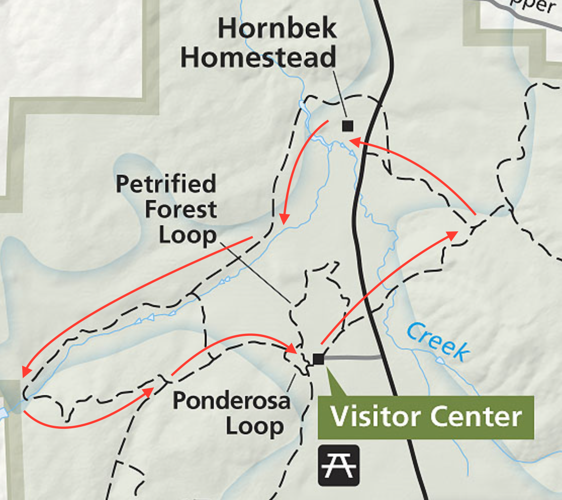
Route taken
Parking Lot 
This area was set aside to protect the Lindenmeier archeological site, a 10,000 year old ice age indian campground originally excavated in the 1930s. This site is the most extensive Folsom tradition site yet found. A shaded kiosk exists overlooking the site and is only a short 0.3 mile trip from the parking lot.

Heading up the Towhee Trail
Looking down from the first ridge
So while the Mammoths, Sabertooth Tigers, and paleo-Bison have long since disappeared, the scenic beauty of this untouched prairie remains. It is not hard to imagine bands of hunters or small family units traversing the area unmolested by the jangle of cell phones. 10,000 years is but a micro-second geologically speaking and so the mountain views, grasses, and seasonal flowers are the same today as they were for our distant neighbors. The memories this place holds whisper softly in the breezes that make the grasses dance.

Snowy locoweed
A grassy field near the start of the Magnolia Loop
The route profiled here starts on the left side of the Towhee Loop, crosses the top of the loop to a short connector trail and then on to the Mahogany Loop, taken clockwise, then back across the connector to the right side of the Towhee Loop. At each trail junction is a large metal post. These posts all have a unique letter identifier on them, which are also listed on the trail map. I wish every trail was so marked!

Loop back on the ridge
Starting out on the Magnolia Loop
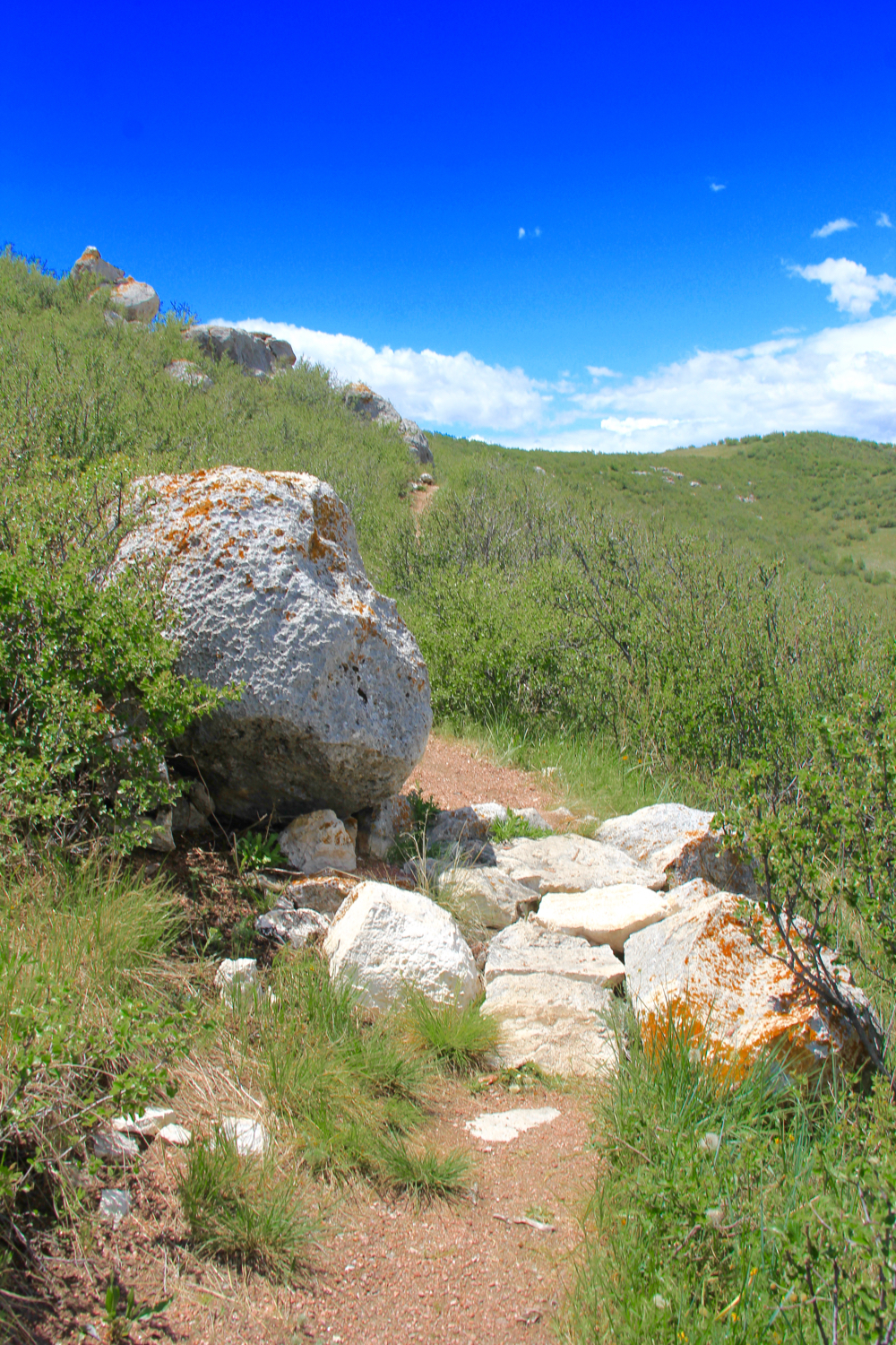
Parts of this route climb up grass-covered drainages while much of it stays on the high ridges with 360 degree views. There are exposed sections of soapstone, which gives the open space its name. Soapstone is a soft talc, basically baby power, that has been used for carving for hundreds of years.

Views to the south
On this trip we saw Pronghorn Antelope, Cottontail Rabbits, raptors, Prairie Dogs, as well as evidence of Badgers. In 2014, a group of highly-endangered Black-footed Ferrets was released here.

A soapstone rock formation
Erosion in action
To get to Soapstone from I-25, take exit 288 (Buckeye Road) west to County Road 15. Go north on CR 15 and turn north onto Rawhide Flats Road. Follow Rawhide Flats Rd to the entrance station. Soapstone Prairie is not accessible via I-25 exit 293 (CR 126/CR 5). Many of these later roads are gravel, rough and bumpy put totally passable by a passenger car.

Tuesday, July 5, 2016

Buchanan Pass

Distance: 10 miles round trip
Elevation: 8,650 ft 9,816 ft
Elevation Gain: 1,166 ft (net), 1,366 ft (cumulative)
Date Hiked: 24 Sept 2015
Bathroom at Trailhead: Yes
Dogs: Off leash until the wilderness boundary (5 miles)
Tags: #peaktopeak, #hike, #coloradooutdoors
Other hikes in area: Caribou Ranch, Lake Dorothy, Arapaho Glacier


Looking down on Middle Saint Vrain Creek  from the rocks around Timberline Falls on the Buchanan Pass Trail
The Buchanan Pass Trail is a gentle, wooded trail that travels from Camp Dick off Highway 7 north of Nederland, over the Continental Divide, to Monarch Lake. The full length is primarily used by backpackers but day hikers can easily do an out and back of any length. This post describes and out and back to the wilderness boundary located five miles in for a ten mile round trip hike.

Map to the trailhead
Parking area with kiosk to the left and 4x4 road straight ahead
Buchanan Pass is largely forested.
To access the trail, drive all the way to the end of FSR 1141 (through the Peaceful Valley and Camp Dick campgrounds) until the road dead ends at a large parking lot (see map). There is a kiosk to the left and a gnarly 4x4 road that heads due west. Start by hiking over the large pile of rocks at the start of the road. The rocks were put there by the Forest Service to deter anyone without a tank from proceeding further. The official trail veers to the right at 0.14 miles at an obvious trail sign.

Unnamed cascade along the creek
Fall color
At 2.3 miles in is the large rock overlooking a gorge that is technically Timberline Falls. You can't see much of the falls, but you can climb onto the boulder and for nice views up and down the river. This is a perfect destination for a shorter hike.

Another view of the creek from around Timberline Falls
Fall color
At 3.13 miles the route crosses the creek and at 3.75 miles it travels across a large talus field. Shortly thereafter, at 4 miles, is a very large meadow with views of Sawtooth Mountain (12,304 ft). A titan-sized gum ball on the right makes for a dramatic locale. This is another great place to turn around for a shorter hike.

Talus field from the far side looking back
Large meadow with views of Sawtooth Mountain
In the final mile between the meadow and the wilderness boundary, the route will rejoin the 4x4 road and walk along a rocky segment to a large backcountry camping spot. Stop here or continue a few hundred yards to the wilderness boundary.

Fall color
View of the creek near the backcountry camping spot. 
The Buchanan Pass Trail is a great spot to enjoy a long hike or a shorter hike with out of town guests. It is both serene, dog friendly, and lovely in the fall.

Intersecting the 4x4 road
Wilderness Boundary 

Thursday, June 23, 2016

Colorado Trail (Segment 3) Wellington Lake to Buffalo Creek

Distance: 8 miles round trip
Elevation:8,262 ft - 8,390 ft
Elevation Gain: 935 ft (cumulative)
Bathroom at Trailhead: No
Dogs: Off leash
Tags: #ColoradoTrail, #coloradooutdoors, #hiking
Other hikes in area: Gashouse Gulch, Pine Valley Loop

This short stint on segment 3 of the Colorado Trail is cushy on the paws and mellow romp through the trees.
The Colorado Trail stretches almost 500 miles across the state from Denver to Durago. Divided into 28 segments, it can be hiked in 4-6 weeks straight through, in segments, or just in bits and pieces because it is so dang beautiful.

Trailhead
On this trip I was looking for a trail I had not done that would allow an off leash dog. Looking on the topo map I decided to head down towards the Wellington Lake Trailhead and hike eastward (away from the wilderness area) toward the Buffalo Creek Trailhead.

This segment is mostly in the trees
This bit of the Colorado Trail was a delight. The ground was a magic carpet of pine needles...soft and nearly rock free. While in the trees most of the time, the forest was open and airy and I was able to keep and eye on the dog as she bolted hither and yon. It was so smooth and level that I found myself walking along at over 3 mph.

Rock piles occasionally appear
The only downside was the lack of water and the sparse views. There was one meadow with a view of the Castle, an eroded rock pinnacle to the west of Wellington Lake, but that was about it. There is a rifle range 3 miles in, which was very active. Handgun fire to small nuclear explosions could be heard a long way off.

Most of the trees are Ponderosa, but this stint contains mostly Lodgepole
You get to the trailhead from Denver by heading up highway 285 to Bailey and then south on Forest Service Road 560 towards Wellington Lake. 560 is paved for only a short distance but then becomes hard packed dirt. Two other FSRs branch off from 560. If you stay to the right you'll find the trailhead, which is located on the right hand side of the road and very obvious.

View of the Castle
My turn around point just past 4 miles one way 
This backcountry campsite made a great lunch spot

Thursday, June 16, 2016

Florrisant Fossil Beds: Hornbek Wildlife - Boulder Creek

Distance: 5.4 mile loop
Elevation: 8,328 ft - 8,639 ft
Elevation Gain:1,067 (cumulative)
Dogs: No (National Monument)
Bathroom at Trailhead: Yes
Tags: #FINDYOURPARK, #NPS100, #pioneers, #fossils
Other Trails in the area: Petrified Forest Loop, Dome Rock

A scenic section of the Boulder Creek Trail that travels along the edge of the ancient Florrisant Lake bed
Florissant Fossil Beds near Woodland Park, CO contains one of the richest finds of insect fossils in the world. It also has miles of trails to explore as well the fossilized giant sequoia stumps. Most trails also have stunning views of west side of Pikes Peak, Colorado Springs native 14er.

Map of the route
Looking across at the first hillside
This post profiles a longer walk that wanders in and out of tree covered hills, crosses a meadow covered ancient lake bed, and stops to sightsee around a well-preserved pioneer homestead.

First a quick note about the fossils that made the area so famous. These formed because 33 million years ago a nearby volcanic field released a 2-story deep mud flow that covered the base a forest of giant sequoias. Eventually, the trees died at the level of the flow, but the stumps remained entombed in mud. These stumps can be seen on the short Petrified Forest Loop as well in a display behind the visitor's center. Another volcanic mud flow dammed a river, forming a lake. Insects and plant leaves drifted to the bottom of the lake where they were preserved in volcanic ash.

Old schoolhouse south of the trail
In the pine forest
Crossing out into the meadow
This trail starts out heading east on the Hornbook Wildlife Loop. After crossing Teller County Road 1, it heads steeply up into a mixed coniferous forest. Every tree seemed to have a bird competing for the loudest chirp or squawk. We saw lots of Chickadees, Mountain Bluebirds, and Filckers just to name a few. At one mile is the junction with the Shootin' Star Trail. Stay left and head down into a meadow and back towards CO Rd 1.

The Hornbek Homestead
Crossing the lake bed
Heading into the far valley
As soon as the trail crosses the road, the Hornbek Homestead comes into view. This well preserved homestead contains a two-story home, out buildings, and several wagons.

Beyond the homestead, the trail travels 2.5 miles along the edge of the ancient lake bed until it reaches a picturesque pile of Pilkes Peak Granite (4 miles total). These red rocks hide a little water fall and is a great place to sit and admire the Aspen trees that grow nearby. All along this segment, views of Pikes Peak abound.  The final 1.4 miles returns to the pine forest with some additional steeper sections.

Rock pile at the end of lake bed
Crossing Boulder Creek
Final stretch in the trees
Even if fossils don't interest you, the scenery and ease of travel will captivate. If you have extra time, drive to nearby Victor to explore the mining ruins of Battle Mountain and Vindicator Valley. To get to Florissant, take US 24 out of Colorado Sprngs. Exit to the town of Florissant, then follow signs two miles south on Teller County Road 1 to the visitor's center.

Fossilized sequoia stump

Thursday, June 9, 2016

Florissant Fossil Beds: Petrified Forest Loop

Distance: 1 mile loop
Elevation: 8,400 ft
Elevation Gain: minimal
Bathroom at the Trailhead: Yes
Dogs: No, National Monument
Tags: #FindYourPark, #NPS100, #ColoradoSprings, #fossils, #naturewalk
Other hikes in area: Hornbook Wildlife Trail, Dome Rock 

Fossilized redwood stumps are the star of the Florissant Fossil Beds National Monument
Florissant Fossil Beds near Woodland Park, CO contains one of the richest finds of insect fossils in the world. It also has miles of trails to explore as well the fossilized giant sequoia stumps. Most trails also have stunning views of west side of Pikes Peak, Colorado Springs native 14er.

Starting out
This post profiles the short nature walk that starts right at the visitor's center and wanders out into the remains of a prehistoric lake bed, now a grass covered meadow.

Interpretive signs put the Eocene age in context with the other major  earth epochs. 
Mountain Bluebirds, hawks and Vultures, Mule Deer, and Pronghorn Antelope frolic the meadow, but the real stars are the sequoia stumps, some of which have been unearthed for your viewing pleasure. You can get up close and personal to at least one.

One stump is not fenced off, you can walk right up and touch it. It looks and feels like wood. 
The fossils formed because 33 million years ago a nearby volcanic field released a 2-story deep mud flow that covered the base of the trees. Eventually, the trees died at the level of the flow, but the stumps remained entombed in mud. Another mud flow dammed a river, forming a lake. Insects and plant leaves drifted to the bottom of the lake where they were preserved in volcanic ash.

Heading back across the meadow
To put this period in perspective, 33 million years ago was an age of mammals, the dinosaurs having long since gone the way...well...of the dinosaur. Before the ice ages that brought the Wooly Mammoth to what is now Colorado, this period contained large herbivorous proto-rhynoceri and other strange creatures.

Big Boy stump. A hotel used to exist in front of this stump and folks had to pay a fee to see you. Unlike today though you were allowed to climb on the stump and take chunks out of it. 

Thursday, June 2, 2016

Trail Through Time

Distance: 1.5 mile loop
Elevation: 4,514 ft
Elevation Gain: 200 ft
Bathroom at Trailhead: Yes
Dogs: Off leash
Tags: #coloradooutdoors, #dinosaurs, #westernslope, #wildflowers, #lizards
Other Trails in the area: Rabbit Ear's Trail, Utah Juniper

Dinosaur bones are visible on the Trail Through Time
Wander in the footsteps of Camarasaurus and Diplodocus on the "Trail through Time" near Fruita, CO. This is short paleontological trail contains visible dinosaur bones and fossilized plants along with modern day lizards and flowering cacti. 

Heading up the hillside
The Dakota Formation
150 million years ago this area was a swamp filled with bus-sized sauropods. Now those swamps are entombed as the Dakota formation, a conglomerate layer of rocks and sand. The trail describes this formation and through a series of interpretive signs, describes the Jurassic landscape.

A lizard basks in the sun
Looking south over the Rabbit Valley. The trail can be seen several hundred feet below.  
Views of the desert abound from the trail, which switchbacks up a small hillside. To the south is the La Sal mountains, which rise sharply out of the desert floor. These mountains are the remains of a "bubble" of hot molten lava that intruded into the thick sediments of the Colorado plateau 29 million years ago. Over the millennia, the surrounding sediments have eroded away, leaving these 12K ft peaks. That is a lot of erosion!

You get to this trail off of I-70 at exit 2. It is a short one mile drive to the trailhead. Brown tourist signs mark the way. This is the same exit as the Rabbit's Ear Trail with its stunning views of the Colorado River.

Claret Cup Cactus and other plants bloom in spring on the Trail Through Time  
Don't linger too long on this trail, however, or you may just join the dinosuars...preserved in rock for all time.

Heading back down

North Rock Creek Snowshoe

Distance: 4 miles round trip Elevation: 9,180 ft to 9,780 ft Elevation Gain: 600 ft Dogs: Off leash until the wilderness boundary North...