Saturday, June 8, 2013

Antelope Park (Button Rock...Hall Ranch) Loop

Distance: 7 mile loop
Elevation: 5,972 ft - 6,731 ft
Elevation Gain: 1,600 ft cumulative
Date Hiked: 14 April 2013
Bathroom at Trailhead: Yes but up the trail a bit
Dogs: On leash until Sleep Lion Trail

Rock formations and open meadows dominate Antelope Park.
Antelope Park is a long sloping meadow nestled between the Button Rock Preserve and Hall Ranch in Lyons Colorado. At the far eastern end is a large pile of rocks that make for an interesting destination. This loop hike is not on any maps, but is easy to navigate on the ground and will transport you back in time to the age of the Colorado pioneers who lived and worked ranches in the hidden valleys between Lyon's and Estes Park. 

The trailhead parking lot
The first 0.9 miles follows this private road. 
Because this trail is so little used, there are few places where the trail itself fades into the grasses, but most people should be able to navigate these sections with minimal angst.

The turn off for the Sleep Lion Trail
The turn off for Antelope Parks is the small spur trail to the left.  The  loop will end up returning to this  point down the main trail. 
The route to and from the rocks traverses several different Front Range biomes including a Ponderosa Forest, open grasslands, riparian (think frogs) lowlands, and rocky traverses. While it may become "hells half acre" in the heat, in spring and fall it is delightful and in the "lusty month of May" you might just see a fairy or two.

The initial part of the loop goes steadily upwards through Ponderosa Pine and rocks. 
This loop starts and ends at the parking lot for the Sleepy Lion Trail in Lyon's Button Rock Preserve. On the west side of the lot is a gate that allows residents of the area access to a broad flat road that heads east towards the Ralph Price Reservoir.  0.9 miles up the road is the turn off for the Sleepy Lion Trail, which is well marked by a sign. While the main route for Sleepy Lion continues straight up the hillside, the route to Antelope Park splits off only 0.1 miles up the Sleepy Lion Trail across from a green and white sign. This split look like a social trail and decsends down into a ditch but quickly ascends up the other side.

The segment where the trail fades.  
The initial part of the route weaves upwards through a long series of switchbacks that also take the hiker back in the general direction of the parking lot. You will realize this when you end up at a view point looking back down the road. At 1.3 miles is an unmarked trail junction. Stay right. At 1.5 miles is a small social trail to a pile of rocks. Stay right here as well.

A segment in the trees
The route then skirts to the west of two oval hills, which can be clearly seen on the topo map. These hills form the northern boundary of Antelope Park and the route stays close to the hills as it heads steadily upwards and eastwards towards pile of rocks. There are several places along this side of the meadow with views of bucolic downs suitable for garlanded maidens in diaphanous dresses or for the less imaginative, the occasional cow. At 2.4 miles you will go through a fence used by ranchers in days gone by.

Entering the wide meadow of Antelope Park
Approaching the rocks
At 2.8 miles and 6,715 ft the rocks that mark the apex of the loop appear just below the crest of the meadow slope.  They stand starkly puritan over the fairy tale frolics of Thumper, Maid Marion, and Tinkerbell whom I could sense tittering on the wind just waiting for us to leave. Around the rocks are several other trails. The Button Rock Trail, which will be part of our loop, heads back down the middle of the meadow. Someone cut down a large oak tree recently and chunks of log make for a suitable spot to lounge. 

Leaving the rocks and heading down the center of Antelope Park
Further down the meadow
Since it was not quite spring when we did this hike and a bracing breeze was blowing down from the mountains we did not linger long at the rocks but headed back down the meadow at a steady clip. The views in the meadow are even better than those from the side. The two oval hills are obvious to the north, and the trails winds in and out of meadow and forest as it heads steadily downwards. Don't assume the fairies are leading you astray when the trail switches from single track to road to single track again. Just follow the signs. The first one will appear at 3.0 miles.

The trail leaves the road and transitions back into the forest at this sign.
Standing on the Sleep Lion Trail looking back on the route towards the Button Rock Trail (sign in the distance). 
The final section of route at 4.9 miles is on the Sleep Lion Trail as it travels around rock formations, more meadows, and more Ponderosa Forest. By the time you reach the road at 5.9 miles, you'll be glad to stride out for a mile back to the car.

On an open segment of the Sleep Lion Trail
If you like the hikes around Lyons (Lion Gulch, Sleepy Lion, Rabbit Mountain, and Hall Ranch), you'll enjoy this hike as well. Just say hi to the fairies for me.

Saturday, April 27, 2013

Mt. Sanitas

Distance: 3.4 mile loop
Elevation: 5,520 ft - 6,843 ft
Elevation Gain: 1,323 ft (net) 1,444 ft (cumulative)
Bathroom at Trailhead: Yes
Dogs: Off leash with Boulder green tag
Date Hiked: 13 April 2013
Tags: #Boulder, #osmp, #peak, #hiking, #coloradooutdoors

View of Boulder from the Mt. Sanitas Trail
Hiking up Mt. Sanitas in Boulder is like hiking a mini 14er.  It is rocky, straight up, and is blessed with false summit after false summit.  It is also crowded with locals who swarm up the trail in their own personal quests for maximum cardio vascular fitness. Feeling similarly, Mt. Sanitas along with Royal Arch and Gregory Canyon are my favorite spring training hikes. They will get the quads in shape for summer hiking and burn sufficient calories to make eating chicken wings less of a guilt trip.

The parking area
The beginning of the Mt. Sanitas Trail.  Mt. Sanitas is a large hogback ridge (the harder remnants of an eroded uplift of sedimentary rock).
The initial part of the trail is a long series of log steps.
While crowded, Mt. Sanitas is not for everyone.  There are wooden steps, rock clefts, loose gravel, and moves that requires some grunt-producing lunges upwards.  If you are used to a well-defined trail or have knee issues, skip this one. If on the other hand you want a taste of real hiking close to home, give it a whirl.  The views along the way of Boulder to the east and the Indian Peaks to the west will make it fun indeed. Unless you are one of the "ubers" running the trail, having both hands free is recommended for the occasionally required rock scrambling . On this trip I carried my large camera and was at a distinct disadvantage. 

A smoother, dirt section of the route
Looking down on the Sanitas Valley Trail and Dakota Ridge (another hogback) Trail
A more typical rocky section
The trailhead for Mt. Sanitas is located on Mapleton Road in Boulder. Within the last few years, Boulder built a new parking lot across the street with a bathroom. This lot still fills up early on weekends and cars will be seen parking down the street for at least a mile. Check out the parking lot first, however, you never know when a spot will open up.

You won't be alone on this trail
View of Indian Peaks
The summit
Heading down the East Ridge Trail
The route starts paralleling Mapleton for 80 yards or so and then crosses over at a small pavilion.  The trail is directly behind this. There won't be any issues of finding the route.  Just follow the steps and the people in front of you.

Having two hands is handy for both the ascent and descent of Mt. Sanitas.
More uplifted rocks
The habitations of the wealthy set cling like barnacles to the northern extent of the Sanitias Valley.
After a lung busting 1.4 miles and 1,323 feet of elevation gain, you reach the rocky summit.  At this point, there are two choices.  Descend back down the Mount Sanitas Trail, or scurry down the East Ridge Trail to the upper reaches of the Sanitas Valley, a wide open space between Mt. Sanitas and the Dakota Ridge. There is a wide fire road (Sanitas Valley Trail) that traverses Sanitas Valley and more narrow trail that travels along the edge of Dakota Ridge. Both will take you to the bottom.  I always prefer to do this hike as a loop, and do descend via the fire road.

Approaching the bottom of the East Ridge Trail

The wide Sanitas Valley Trail.  We had to put Ginger on a leash here due to recent Coyote activity.
Map of the loop

Saturday, April 6, 2013

Dome Rock

Distance: 11 mile loop
Elevation: 8,788 ft - 9,742 ft (maximum elevation)
Elevation Gain: 839 ft (net), 2,160 ft (cumulative)
Dogs: Not allowed
Bathroom at the trailhead: Yes
Date Hiked: 7 October, 2012

Dome Rock is a magnetically attractive extrusion of Pike's Peak Granite.  Just being near it will make you say wow!
The Dome Rock Loop in the Dome Rock State Wildlife Area adjacent to Mueller State Park near Cripple Creek Colorado is a long, and at times arduous trek to an impressive "Devil's Tower"-sized protrusion of pink Pikes Peak Granite. The route varies from soft dirt amidst Aspen groves, to get-your-feet-wet stream crossings, and finally to gravel strewn deer paths on steep sloping hillsides.  Because of the challenges in terrain as well as the overall distance, I can only recommend this to the hardiest of hikers. If you are not scared off but such trivialities, however, then you will love the geology, solitude, and diversity of flora that this area has to offer.

There are two trailheads. This one starts the loop heading clockwise.
The initial part of the route heads up this valley.
A quick note before you race out the door...50% of this loop is closed from December 1st to July 15th each year to protect the local Big Horned Sheep. Don't let this discourage you, however. With all the Aspens in the southern portion of the route, you'll want to go in the fall anyway.

There are two parking lots at the trailhead. Since we did this as a loop, we chose to park in the lot where we would be coming OUT and therefore save ourselves an additional 0.2 miles at the end.

The first half of the route weaves in and out of Aspens.
A typical false summit on one of the many hills
While you can take this loop in any direction, I was with a friend who was familiar with the area and she chose to take the loop clockwise so we headed due south on the Willow Creek Trail. This trail climbs steadily along a wide dirt road surrounded by Aspen trees. It weaves up and down with occasional views of the surround hillsides until it reaches its highest point at around 9,742 ft. With so many false summits along the way, you won't realize you have crested until the last ascent is well behind you.

At 3.0 miles we came to the junction of the Sand Creek Trail. I would not recommend taking this route because at the far end, the trail intersect a flooded valley that you will have to either slog across or go around. Our route will have to deal with this area as well, but in a less dramatic way. 

I need to make a comment about maps at this point. I have two maps to the area. One is the standard National Geographic Topo Map and the other is a trail map provided by the Colorado Division of Wildlife. While similar, the placement and route of the Sand Creek Trail is totally different on these two maps. Given my GPS mileage to the junction, the National Geo map is more accurate.

A Mule Deer watches us cautiously as we go by.


Many of the views from the false summits are of Aspen strew hillsides.
Trail closure sign
The junction with the Spring Creek Trail is only 0.3 miles beyond the junction with the Sand Creek Trail. There is a VW-sized sign indicating the seasonal closure dates I mentioned earlier, so it will be impossible to miss. From this point on the trail will descend and descend 2.5 additional miles through Aspens galore. At times benign, and at other times steep, this part of the route is on a narrow dirt track that is easy to follow.

Further along, walls on either side will begin to close in as the route descends through a sharp canyon. The wall on the right hand side is actually Dome Rock, but it won't be apparent until you break out into the meadow on its far western side. Other huge rock formations surround the area as well and they were quite alluring until we were far enough way from Dome Rock to turn around and bask in its immensity.

Heading down towards Dome Rock is on a more narrow rutted trail.
The valley around Dome Rock is bordered by high rock walls.
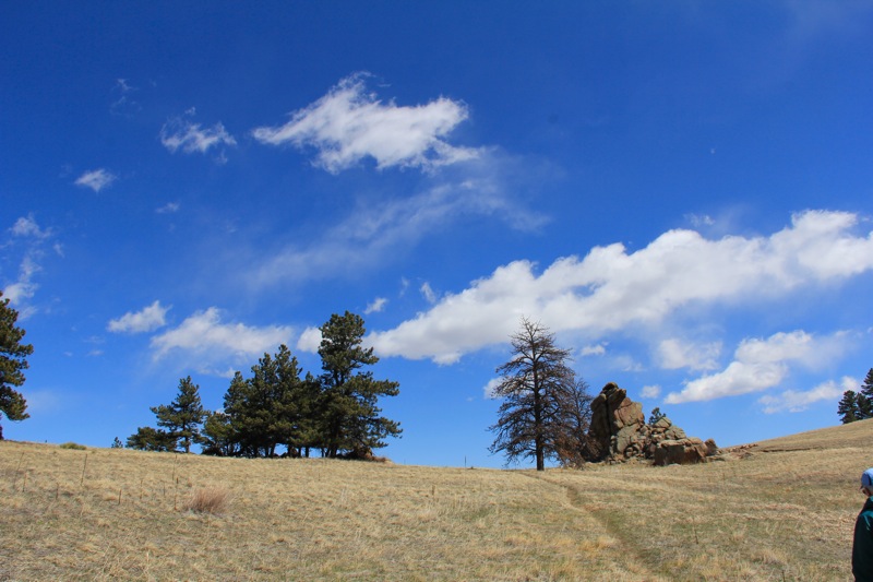
Dome Rock from the side
If you have not guessed by now, Dome Rock is impressive. Like the Thumb of God protruding forcefully from the ground, you can almost feel the magnetism of that much fire-formed granite. We ate our lunch in the meadow near the junction of the Dome Rock Trail at 6.2 miles in. This trail is not on the Division of Wildlife Map.

From this point the route travels up and over the shoulder of another large, bulbous out cropping of rock until it turns eastward for the long slog back up to the parking lot.  It is this portion of the route that things get tricky.

The first stream crossing.  This one is required to get to the meadow with the views of Dome Rock. Even in late fall it was ankle deep.
The meadow around Dome Rock.  A great place for lunch.
If you look on the map, the route crosses the stream to the southern side and then continues up the canyon. This entire area has been turned into a swamp by the local beavers and the original trail, which crisscrosses the area is under water. There is no warning signs about this, and if you follow the well trodden route you will find yourself lost, and not happy snuggling up to the buck-toothed cause of your frustrations. My hiking companion and the one couple we saw on the other side yelling at each other in "you did this to me (*%&@$#)(%!!!!" staccato sentences can attest to it.

After the meadow, the route heads up this drainage before turning to the right at its far end.
The initial rabbit tail on the left side of the flooded valley.  At times difficult to follow and at others very obvious, staying on the left side of the valley will keep you dry.
The way to escape, is to look around carefully at the first water crossing for a small rabbit trail leading off into the shrubby.  Follow this and STAY on this side of the river, no matter how tempting the main trail is and you will find your way out of the canyon. The route on this side of the swamp is at times easy to follow and at times wanders through the shrubbery. If such route finding is something you don't like, turn around at Dome Rock and retrace your steps. 

Because the water covers most of the valley floor, the route on this side is further up the hillside and therefore occasionally traverses some steep, gravel strewn terrain. While you won't fall to your death is you slip, you will come away with some road rash and possibly a twisted ankle. A hiking pole would mitigate the hazards of these segments.

Looking down into the flooded valley.  The original trail is across the water at the edge of the pine trees.
Another view of the left-hand route with bogs to the right.
At 8.6 miles you will come to the ruins of the Jack Rabbit Lodge. There is a trail junction here as well. Remember you stay straight or you will find yourself deep with the confines of Mueller State Park and very far from your car. 

At 10.4 miles is a bridge. Stay left here and you will reach the upper parking lot at 11 miles after a steep climb out of the canyon.

While I can't recommend this area to everyone, I had a blast. While fatigued and ready for a beer at the end, the unique scenery and the unexpected challenges made it all worth while.  If you consider yourself a seasoned hiker, give Dome Rock a try. The Aspens alone will wow you.

The path on a steeper hillside
Finally out of the flooded valley the route is clear sailing on a well defined trail.  It just goes UP quite a bit before you reach the trailhead.

North Rock Creek Snowshoe

Distance: 4 miles round trip Elevation: 9,180 ft to 9,780 ft Elevation Gain: 600 ft Dogs: Off leash until the wilderness boundary North...