Saturday, September 1, 2012

Sloan Lake and the American Basin Trail

Distance: 3.2 miles round trip
Elevation: 11,600 ft - 12,941 ft
Elevation Gain: 1,341 ft
Date Hiked: 16 July, 2012
Dogs: Off leash
Bathroom at the trailhead: No
Tags: #hiking, #mountainlake, #coloradooutdoors, #gearguide


Sloan Lake in American Basin is nestled in one of the prettiest places in Colorado.
Sloan Lake out of American Basin in the San Juan Mountains is not the most spectacular lake in Colorado, but the journey will rock your world and twirl your planets!

Early morning at the trailhead
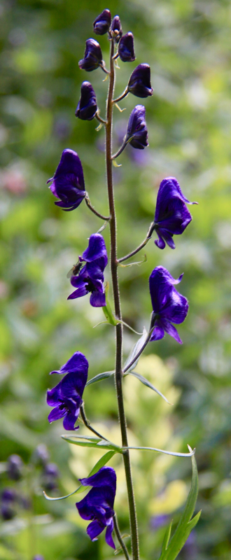
Columbine along the trail
The sun finally touches the rock formations at the back of the basin
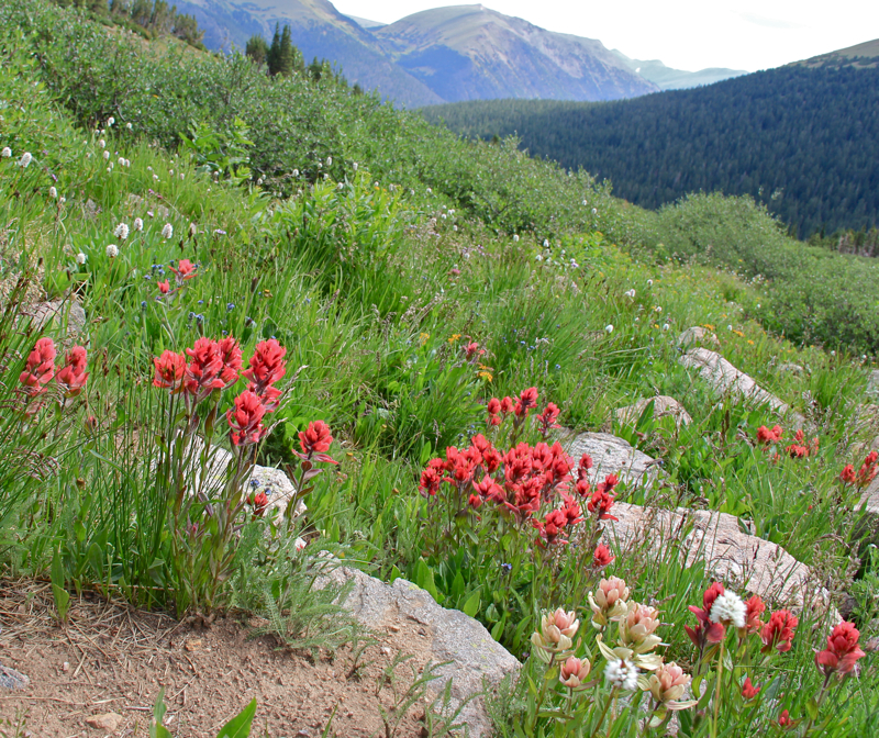
American Basin, twenty miles from Lake City, is a glacial carved valley with jagged rock formations at the far end.  At the right time of year the basin is filled with wildflowers and peak baggers on their way to Handies Peak.  At the far end of the basin is a rock glacier.  Rock glaciers are different from ice glaciers in that the water is not a solid mass, but exists between the rocks so all you see is flowing (in geologic time) rock. To me it looked like a giant multi-"toed" amoeba ready to gobble us whole. 

American Basin is known for its wildflowers.  While the other hikers we met said this was  a poor year, I was hardly disappointed. 
Heading up the trail now
Larkspur 
The route travels up the left side of American Basin, gradually gaining altitude before veering to the left an onto a shelf for an adjoining basin. Another rock glacier lies in the distance and Handies Peak is off to the left.  Turn around at this point for spectacular views back down American Basin.  The rugged rocks and green tundra grasses are quintessential apline terrain.

The tongue of the rock glacier is just ahead
Looking back down on American Basin from the perpendicular shelf
The lake is on the shelf to the right.  The route will go up and over the small berm in the foreground than and then switchback up to the shelf on the berm in the middle of the image. 
Once on the shelf, the route heads straight back before suddenly switching backing up the right side of the basin. At the top is a large cairn. This monument marks the junction between Sloan Lake, which is only a 30 yards or so away and the route up Handies, which crosses the rock glacier and over to the other side of the basin.

Heading across the shelf
Almost to the top
The large cairn marks the junction of the trail to Sloan Lake,  which is just ahead, and the trail to Handies Peak
The volcanic nature of the San Juans is evident all around the lake, which is bordered by coarse igneous rock.  While we were visiting the lake on our return trip from Handies, we ran into a couple who hike to the lake every year.  We ran into quite a bit of wildlife on the way including Ptarmigan and baby Marmots.
 
View of the lake
Looking back down on the lake as we continued up towards Handies Peak
While I can't gush enough about this area, I must warn you that getting to the trailhead is a chore.  While maps and guidebooks say the road to American Basin is passable by a passenger car, we had trouble in our 4x4 truck.  If you really want to do this trail, I would suggest renting an ATV in Lake City.  An ATV will get you up and over the rocks but will be much thinner and shorter the better to pass other like minded individuals on the narrow shelf road.

Saturday, August 18, 2012

Carolyn Holmberg Preserve at Rock Creek Farm (Stearns Lake)

Distance: 3.6 miles round trip
Elevation: 5,276 ft
Elevation Gain: Nominal
Date Hiked: 8 July 2012
Bathroom at Trailhead: Yes
Dogs: On leash (Boulder County Open Space)
Tags: #lake, #bcos, #stearnslake

Looking at Stearns Lake in the Carolyn Holmberg Open Space
The Carolyn Holmburg Perserve at Rock Creek Farm is a small Boulder County Open Space located north of Broomfield on Highway 287.  It is popular with fishermen and locals taking strolls with their kids and dogs.  Located in the middle farm land, it is very pleasant in the spring and fall and is usually snow free in the winter.

Trailhead with parking and picnic enclosure
Starting out on the Mary Miller Trail
I chose a steamy day in July 2012 (can you say record heat anyone?) to try running the trails in the park so I grabbed my cell phone to track my pace and distance as well to take pictures on the fly. If the pictures in the post don't seem up to snuff, that is why.  In the humid air, my phone was like a wet bar of soap

Farmland stretches off to the right.  The lake is on the left behind the berm.
The route leaves the lake (out of frame to the left) and heads off to the east.
There are several named trails in the area, but the logical route is to leave the parking lot and head due west along the shore of Stearns Lake.  Technially, this is the Mary Miller Trail, but that name is not evident as you leave the parking area. As you head east, you may see Canada Goose, which frequent the Cottonwood-lined shoreline.

The road leading due east that intersects the trail.  The directional sign is on the post to the right.
Close up of the directional sign.  The arrows point down the road.  I am not sure this is how they want people to go.  If you avoid this turn you come to another trail sign further up the road.
On the far eastern side of the lake there is a large gate and dirt road that continues directly eastward.  Attached to the right-hand post of the gate is a trail sign with two arrows.  This sign was just loosely attached with some wire and was twisted in such a way that the arrows were pointing down the road.  This is NOT correct.  While you can take this road, it may be private so when you come to this junction, continue northward until you see a large trail sign pointing to the right.

If you keep going this is the sign that point to to the trail as it forks eastward.
Looking back towards the lake near several interpretive signs.  Farmland is on either side.
From this point of the route, the trail heads eastward along a slight ridge looking down on a working farm.  I chose to turn around when the dirt trail turned to pavement as it connected to a bike path heading under Highway 287.

My turn around point.  This is where the gravel path becomes paved and travels under Highway 287.  Note the farm buildings in the distance.
Back near the trailhead, this is the sign pointing to the Cradleboard Trail, which from this angle heads off to the right.
After running back around the lake, I took a left on the Cradleboard Trail, which heads due south before more curving westward.  The Cradleboard trail comes to a junction at a dirt road.  To return to the parking lot, turn right.

A typical segment of the Cradleboard Trail.  The Flatirons can be seen in the far distance.
The junction where the Cradleboard Trail continues southwest and a dirt road wraps around to the north to return to the parking lot.
One of things I love about Colorado is that "parks" are more often open space rather than green grass and manicured deciduous trees.  The Carolyn Holmberb Preserve is a perfect example.  While not large, it is perfect for a short run, afternoon stroll, or picnic at the shelter in the parking area.

The parking is ahead in the distance
Map of the trail system.  The dirt road is marked with a dotted line.


Saturday, August 4, 2012

Butler Gulch

Distance: 6 miles round trip
Elevation: 10, 546 ft - 11,963 ft (at the Jean Mine)
Elevation Gain: 1,238 ft
Date Hiked: 14 July 2012
Dogs: Off leash, National Forest
Bathroom at Trailhead: No

Mountain Views on the Butler Gulch Trail
Butler Gulch,  near the large switchback on the way to Berthoud Pass, is a close-to-Denver alpine journey filled with wildflowers, waterfalls, historic mining ruins, and make-me-move-here scenic views. This trail is fantastic!

The parking area is just the road by a gate
While most of the route follows an old road, it  occasionally gets soggy
Columbine near the trail
Another stream crossing
You get to Butler Gulch by first turning off of Highway 40 at County Road 202 and then heading due west towards the Henderson Mine. Just before the mine, a dirt frontage road splits off and parallels the paved road.  Continue on this dirt road until the parking area right at the junction with the Jones Pass Road.  Park along the side of the road by a large gate.

Monkshead along the trail
The waterfall at 1.5 miles
Indian Paintbrush along the trail
Mosses extend like beach sand from the "forest" of this riparian ecosystem
The lower sections of Butler Gulch are soggy and tree shrouded with several stream crossings and numerous stands of wildflowers. As the trail rises, it comes to a long cascading waterfall at 1.5 miles and finally breaks out of treeline at 1.8 miles. From this point on, the trail travels westward across a wide alpine shelf and finally reaches the remains of the Jean Mine at 2.7 miles.

View to the west as the trail breaks out of the trees
Heading across the shelf to the mine
The Continental Divide to the north
More flowers because I could not resist
Wildflowers dot as well as carpet this high altitude play land and I found myself irresistibly drawn to them as our group continued on their way. I would scurry to catch up only to be distracted by the latest colorful bauble.

From the western end of the shelf looking back at the Continental Divide
Getting closer to the mine
The mine tailing come into view
The ruins of the Jean Mine are interesting as well.  Purists may be offended by the piles of metal, old cars, and defunct machinery that covers the area, but this is our Colorado history and it has been part of the landscape for good or evil for the last 100 years.

Playing with an old car
More ruins
Behind the mine and wrapping around the entire area is the Continental Divide.  There is also a small spur trail leading to a shelf that formally contained a small glacial tarn.

Near the mining ruins was a whole field of Indian Paintbrush
When you see clouds like this above treeline, you should run away!  
If you are from the Denver area and are trying to decide whether to petal peep at Diamond Lake in the Indian Peaks Wilderness or on Butler Gulch, choose the latter.  It will be significantly less crowed and may actually have more wildflowers.


Wednesday, August 1, 2012

Ptarmigan

A White-tailed Ptarmigan (Lagopus leucura) munches on Bistwort in the meadows below Handies Peak in the San Juan Mountains
Numerous lakes, trails, coffee shops, and ski runs have been named for this elusive member of the Grouse family that lives exclusively in the alpine zone.  I have only seen it twice in Colorado. Once was on Mt. Sniktau and the other was on the way to Handies Peak. Their elusiveness may have nothing to do with scarcity but more to do with their superb camouflage.

Compare the rock with the plumage of the Ptarmigan.  At a distance, would you be  able to see them?
In winter they are totally white, while in summer they are a specked brown. Once I realized I was in a flock of them,  I started looking around and they were everywhere but I had to squint and stare to see them against the talus. They eat everything from alpine wildflowers to the twigs of willows. The young start out eating insects and then move on to more tastier fare.

This Ptarmigan still has a little be of white on its underbelly.  These birds are supposed to keep their white tails.  Perhaps this is a juvenile. 
Superbly adapted to the cold, this bird had feathers on its feet and around its nostrils to keep both regions warm. Just thinking about it makes me want to get a pair of down booties!


North Rock Creek Snowshoe

Distance: 4 miles round trip Elevation: 9,180 ft to 9,780 ft Elevation Gain: 600 ft Dogs: Off leash until the wilderness boundary North...