Distance: 5.2 miles round trip
Elevation: 11,100 ft - 13,200 ft
Elevation Gain: 2,100 ft
Date Hiked: 3 September, 2011
Bathroom at Trailhead: No
Dogs: Yes
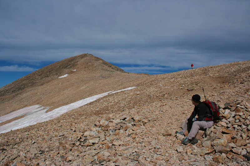
 |
| The precipitous trail to Argentine Pass |
Argentine Pass is a destination most reach by driving their 4x4 or ATV up from Waldorf (out of Georgetown CO) . The hiker can reach it, however, by hiking up the arduous goat track along the slope of Argentine Peak. I have wanted to do this hike for years, and this year I got my chance.
 |
| Driving into scenic Horseshoe Basin at the end of Peru Creek |
 |
| Walking by the ruins of the Shoebasin Mine |
The trailhead for Argentine Pass is located at the end of Peru Creek Road near Montezuma in Summit County. While this road is passable for passenger cars, at least to the trailhead for Chihuahua Gulch, it becomes increasingly rough thereafter so don't try this in your passenger van. It is only 4.6 miles in, but when you are traveling 5 miles an hour, it takes a while.
 |
| Walking up the road |
 |
| White coated rocks. The British geologists we met speculated it was due to Kaolinite Clay coating the rocks. |
At the end of the road is a large parking lot on the left. Don't go beyond this. The road drifts behind a hill just past this lot and there is a gate blocking further progress that you can't see until you make the bend.
 |
| The unmarked sign indicating the start of the trail. The pass itself is visible to the left. |
 |
| The route follows the hillside to the left |
The trail itself begins at a small unmarked sign in the willows 0.4 miles up this road. I ran into a volunteer ranger coming down who said it took her an hour to find this spot. We did not have this difficulty but kept wondering where it was as we slowly slogged up the very rocky road. Just keep going, you'll know it when you see it.
 |
| The first bend is just ahead. Decatur Mountain is to the right. |
 |
| Stunning views back down Peru Creek Valley |
After the initial turn, the trail crosses the valley through willows taller than I was. It begins to climb quickly on the other side and will do so unrelentingly until you reach the pass.
 |
| The initial part of the route. There are still plants on the slope. Grays Peak is to the left. |
 |
| Looking down on the route through the willows |
Argentine Pass Trail has just one switchback and you reach this around 1 mile. The turn here was so rocky, it looked like a stream bed, which would make the route an ankle twisting nightmare. Fortunately, it is not. At the bend, you are already above treeline and a pleasant looking ridgeline is just ahead. It looks trivial to climb Decatur Mountain to the right and someday I hope to return and do just that.
 |
| The route becomes more barren, where is the pass? |
 |
| Clouds loom where only the thistle bloom. From this point we were still several crenelations away from the pass. |
The views looking back down Peru Creek Valley are stunning from this point and if you are looking for a shorter outing, you could turn around right at the bend and call it a day. If you continue on, it is another 1.6 miles to the pass. Note, the guidebooks all say it is 2 miles to the pass, but add on the distance from the parking lot to the trailhead and another 0.2 miles of navigation error and my GPS said the distance was 2.6 miles one way.
 |
| Traversing a wide area. On the very narrow spots, I did not take pictures. I needed both hands at the ready in case I slipped. |
 |
| At last the pass comes into view |
The terrain on this part of the route is unchanging. It is rocky, very narrow in places, and devoid of vegetation accept for the mysterious
Frosty Ball Thistle. You can't really see your destination from the trail because it continually weaves in and out of drainages that hug the mountain side and the ridgeline in the distance all looks the same. This trip became an exercise in "are we there yet" as we took turns on point hoping the next bend in the trail would show us the pass.
 |
| Argentine Peak from the pass |
The views from the route are amazing, so don't let the tedious nature of the trail itself deter you. The entire time you are looking down into a bowl bordered on the north by
Grays Peak (14,270 ft) and Ruby Mountain (13,228ft). To the east is Mt. Edwards (13,850 ft) and of course Argentine Peak (13,738 ft) is several hundred feet above on the right.
Reaching the pass is somewhat anticlimactic. I have heard that Waldorf on the other side is stunning, but the slope is so gradual, you can't really see much from the pass itself. I had hoped to climb Mt. Argentine from the pass, but we did not get started on the trail until after 1pm and pressed upwards despite the looming black clouds that always seem to shroud this area. Going even higher was out of the question.
 |
| Back down now, admiring an old cabin in the meadow across from the parking lot |
It is the history of this trail that makes it worth doing, however. Initially a stagecoach route and later a railroad, there are places where the trail is still relatively wide and flat. Other places are so narrow a
Pika would have trouble staying level. Every time I looked down I could not help but picture Grandma Moses bouncing along on those wagon wheels as the edge came in and out of view. I have heard stories of pack animals being blown off the ridge and I could well believe it. The relentless snows in this area made this road unprofitable and it was eventually abandoned. The effort folks went to back then to traverse the Continental Divide just amaze me. And I bitch when I have to take Loveland Pass because the Eisenhower Tunnel is closed!
 |
| Late 1800's image of Argentine Pass by Chamberlain, W. G. (William Gunnison) -- Photographer [Public domain], via Wikimedia Commons. |
Hiking to Argentine Pass is not an easy trail. I had climbed
Mt. Democrat two days before and my quads were wondering what on earth I was doing. Knowing the route now, I might return to climb Mt. Edwards or Argentine Peak, but it won't be on the top of my list. Instead, I would rather continue up the road to several shelf lakes that nestle at the base of
Grays and Ruby. We ran into some Brits on the trail who have been in the area many times and have climbed
Grays from that route. They were complaining about the altitude but once they told me that story, I knew their posturing was just for show.