Saturday, June 11, 2011

Dolores River Canyon Hike

Distance: 6 miles round trip
Elevation: 5,000 ft - 5,100 ft
Elevation Gain: 100 ft (net) probably 300 ft (cumulative)
Bathroom at Trailhead: No
Dogs: Off leash

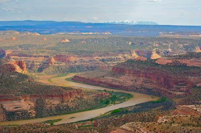
The hike along the Doloras River Canyon near Paradox Colorado is a classicThe scenic Dolores River travels over 500 miles through Colorado, cutting canyons as it goes. The hike out of Bedrock, CO is an easy way to explore this unique topography.

Thought that Arizona has a monopoly on cool looking red canyons? Think again! The western part of the state is crisscrossed by rivers that have carved deep, winding slots through millions of years of sedimentary accumulations.

Looking up the canyon from where we parked at 38°17.742/108°53.884. The first cliff in the distance is the sharp right turn that is 0.87 miles way.

Looking back up the road we drove down toward the entrance to the canyon. The cliffs bordering the northern end of the Paradox Valley are clearly visible in the distance.
The hike along the Dolores River from Bedrock to the junction of the Le Sal creek will take you into the heart of this area and will let you immerse yourself in the red desert dust, sagebrush, and towering cliffs. While WAY out of the way, this is a must do hike for anyone serious about exploring the state.

The flow within the Dolores River is controlled upstream by a dam. Usually just a trickle, the authorities release water at certain times of the year for agriculture and rafting.

We have just made the sharp right turn at 0.87 and are heading further up the canyon. The slot in the center of the picture is our destination.
Bedrock is located up the stunning Paradox Valley on highway 90 between Naturita and the Utah border. The only landmark for this once populated town is the old Bedrock store, now closed, that marks the turn off towards the boat ramp for the Dolores River. We were surprised at how large the parking area was and how full it was given our isolation. The cars were for rafters, however, and not hikers.

The geology of the area is the primary appeal. Ancient sand dunes and river beds form sequential layers of various colored rocks of Triassic and Jurassic periods. The most prominent is the Wingate Formation, formed from dunes around 200 million years ago.

Near the deep stream bed that is reach at 2.0 miles, the ground was filled with layers that were obvious ancient mud beds, which give it this purple color.  This part of the trail was littered with bright teal fragments.
Past the boat ramp, the road travels up a short hill and splits into several directions. It took us a bit to find the road that continues down into the canyon. Be advised, this is a high clearance 4x4 road only. With our truck we managed to get 1.7 miles beyond the split but this entailed gingerly traveling over several large boulders and along a highly eroded shelf. We managed to drive down to a spot with plenty of turn around room, but a couple of jeeps in that area would have made it more complicated.

Looking down into the dry stream bed with its many layers of rocks. Just a few weeks prior to this hike, I hiked to Linville Falls in North Carolina. There I saw similar geology but active water. The contrast was startling.
The trail is close to the river at times and further away at others.
The route follows an old road and is very easy to follow. At times it is close to the river and at times farther away. We were doing this on a hot day in May and drank at least 2 liters of very hot water (the place were staying at had no ice). By the end I was craving an ice cold beer (something I rarely drink), so plan accordingly.

Near the end of the trail, is a large series of boulders that obviously fell from the side of the cliff. Some are upright (e.g. layers are parallel to the ground) and some are on their sides (layers exposed). The one containing the petroglyphs was quite obvious. It is close to the trail and there is a large National Park Service sign pointing them out. What we did not find was the dinosaur tracks that are supposedly on the back side of on of the boulders that is on its side.

It was hard to pick a picture that typifies the cliffs in the area. The reality they surround you on both side and hog the distances.
Some milestones along the way include the sharp right turn at 0.87 miles, a traverse across an old stream bed at 2.0 miles, Indian petroglyphs at 2.5 miles and the junction with the Le Sal Creek at 3.0 miles (our GPS when nuts at this point because the last part is under a cliff shelf and the GPS lost its signal). It looks like one could continue up the Le Sal a way, but the trail descended directly into the willows surrounding the creek, so I suspect the route would be a sloggy one.

The view looking up Le Sal Creek. You can see the trail fading off into the distance.
Topo map of the area. Hwy 90 is visible in the upper right and the Le Sal Creek in the lower left. The sharp 90° turn is noticeable where the river passes close to a sharp point in the relief. The scale and varied nature of the cliffs is also discernible form the map.

Wednesday, June 8, 2011

Plateau Lizard

A pair of Plateau Lizards on the side of a B&B in Paradox Valley

It is not everyday that you can bust in on a couple of Plateau Lizards in flagrante delicti. I don't think they were too happy about my Paparazza voyeurism but they were too self-absorbed to break off their assignation to scurry under a rock.

The Plateau Lizard (Sceloporus undulatus) is diurnal, spending most of its time basking in the sun. It consumes large amounts of insects and spiders. After mating in the spring the female will lay up to 12 eggs in early summer. The young hatch in the fall.

I have seen these lizards called the Eastern Fence (subsp), Prairie, or Plateau Lizard. To the untrained eye, they all look very similar. Growing up in California, we had the Western Fence Lizard, which was know locally as "blue bellies".

Am I being anthropomorphic, but does the female have a bit of a gazed look in her eye, or is it just resignation?

The blue scales underneath the male's belly and near its throat are undoubtedly attractive to the opposite sex. When courting, these lizards will lift up on their legs to flash their blue scales. As with most species the girls like their boys flashy.

Saturday, June 4, 2011

Rabbit's Ear Trail

Distance: 5 miles round trip (out and back to the overlook), 6 miles round trip (if you do the loop)
Elevation: 5,000 ft -5,700 ft
Elevation Gain: 700 ft (net), 1,347 ft (cumulative)
Dogs: Off leash
Date Hiked: 26 May 2011
Bathroom at Trailhead: No

The skeleton of a Utah Juniper stands guard over the vista of the Colorado River on the Rabbit's Ear Trail

The Rabbit's Ear Trail near Fruita, CO and the Utah border is a semi-desert hike to a river vista that will make you drop your jaw and find a rock and gaze stupefied into the distance. Not as easy as it looks, the route travels up and down humps of a ridge until it reaches a plateau 700 ft above the trailhead. From this point on, the trail is flat and the going is soft and easy.

The trailhead with its kiosk

An early trail segment with a smooth path and Sagebrush in the distance

Rabbit's Ear is part of the Rabbit Valley Recreation Area located at exit 2 on I-70 near the Utah border. While the main trails of Rabbit Valley can be filled with ATVers, Rabbit's Ear, 4 miles back west up a dirt road, is for hikers only. We had the entire place to ourselves.

Utah Juniper (Juniperus osteosperma) dots the landscape as clouds hang over the distant western plateaus.

Looking west into Utah. That is I-70 in the distance.
The terrain is rocky with occasional Utah Junipers, tufts of grass, Yellow Rabbitbrush, clumps of the unusual Mormon Tea, and since we did this hike in May, the occasional wildflower.

Desert Paintbrush (Castilleja angustifolia variety dubia) likes hot, dry, sandy soils. It blooms in the desert in early spring. Don't confuse it with Indian Paintbrush (Castilleja miniata), which is found in more alpine settings.


A glimpse of the long ridge ahead. Our destination is the lump on the far right.
The Rabbit's Ear Mesa, whose shape gives the area its name, overlooks the Colorado River as it winds its way through several canyon systems. The sedimentary striations of long lost sand dunes are clearly visible from the trails many vista points. To the east the Book Cliffs and Grand Mesa can be seen in the haze.

Ginger enters the slot canyon at 1.0 miles
The trail traverses both rock and dirt as it climbs steadily higher.
I found myself stopping frequently on this trail. Not only were there numerous critters, plants, and vistas to photograph, but this was the first hike of the season after being laid up all winter with a foot injury and I was sucking wind more than I would like to admit.

Another trail segment heading up through Utah Juniper

A steeper segment
Some mileage points to guide your journey include a small slot canyon at 1 mile, the final stretch to the top of the mesa at 1.36 miles, and 2.3 miles to the best views. The trail does continue around in wide circle past our stopping point but we were doing this in the heat of the day and decided not to take the longer route back (6 miles round trip versus 5 miles round trip). As it was this trail was rougher than I should have been doing first time out of the gate.

Looking down on the Colorado River and colorful rocks of ancient sand dunes

There were several specimens of the Claret Cup Cactus (Echinocereus uspenskii) blooming along the trail. It typically grows in clumps in rocky open areas between 4,000 and 9,000 ft.

At our stopping point, one is gazing down into Ruby Canyon, which has resulted in this trail to be called the Ruby Canyon Overlook in several prominent hiking guides. In the distance is the Black Ridge Canyons Wilderness Area and the entrance to Mee Canyon. Further away are Utah's Le Sal Mountains with their snowy peaks and the broad expanse of the Uncompahgre Plateau, which we planned to drive around the following day.

The view to die for. The Colorado River as it winds through Ruby Canyon on the way to Utah. Tiny rafts dot the river. The snowy peaks of the La Sal Mountains in Utah are visible in the distance.
Heading back down at the edge of the mesa
We could see several large rafts floating serenely down the river. I couldn't help but wonder what the canyon looked like from that level. Certainly, the towering walls must have been majestic indeed.

A photo of rocks, lichens, and a rail tunnel in the distance
A close up of what looks like the Red Crust Lichen (Caloplaca trachyphylla). Lichens are actually two organisms. A fungi and an algae living together in a symbiotic relationship. The algae provides food and the fungi provides the home. They are common throughout Colorado. The Egg Yolk Lichen is another favorite.
There are two common lizards on the western slope that can be hard to tell apart. The Plateau Lizard (Sceloporus undulatus) and the Sagebrush Lizard (Sceloporus graciosus). If I had to guess, I would say the former. These lizards feed on insects, primarily grasshoppers, moths, crickets etc.

If you are in the Grand Junction Area and are looking for a short hike with major payoffs, this hike if for you. Just bring plenty of water and be prepared for changing weather conditions. This is snake country as well, so look before you sit or place your hands on any rocks. We did not see any snakes, but the lizards were out in force, so I know the snakes were out there too.

A close up of Mormon Tea (Ephedra nevadensis). This unusual plant has long, jointed needles. It is highly prized for various medicinal properties.

A parting shot of the river and desert beyond

Saturday, May 21, 2011

Linville Falls North Carolina

Distance: 1.7 miles round trip
Elevation: 3,160 ft - 3,360 ft
Elevation Gain: 300 ft
Dogs: On leash

Linville Falls, taken with my cell phone camera.

On a recent business trip to Asheville, North Carolina, I took an afternoon off and drove the Blue Ridge Parkway from Asheville to Linville Falls.

Typical vista seen from the Blue Ridge Parkway

Below 2000 ft, the hard wood trees were in full bloom but above this elevation the trees were barren and the air chilly. Already enthralled with the area, I stopped frequently and view points to gaze out at the rolling green hills covered in hard woods. It was obvious that in the fall the area would be stunning.

The Upper Falls

Linville Falls is two hours from Asheville and can be very touristy on weekends. There are two options for viewing it. Pictures of both options exist in the small visitor's center so it is easy to decide. Since I was practically wearing slippers (continuing saga with tendinitis), I did not want to walk too far. As it was the trail was rougher than I anticipated. It wandered up and down, over roots, and up and down stairs. Normally a walk in the park, this route was more than I should have been doing. It was so scenic, however, that I am glad I broke the rules.

Looking down into the S-curve of the Linville River just before the Falls

The falls is actually a series of falls. The first is the twin Upper Falls. A nice view point allows the visitor to wander over layers of sedimentary rock and look straight at this first step. Turn around and water flows through an intriguing S-curve that has been eroded from the cliff face over millions of years. It is dramatic to say the least and a testament to the power of water.

The eroded channel just to the left of the S-curve

The Chimney View Point is reached 0.3 miles beyond the cutoff to the Upper Falls and is on the other side of the gorge and partway down the cliff face. From this vantage point, the 45 foot drop and surround cliffs are clearly visible. Turn around and one can follow the river as it heads to the entrance of the Linville Gorge itself.

Another view of the falls from the Chimney View Point

Anyone interested in Geology will be interested to know that the Falls spill over an actual Thrust Fault. The rocks along the Upper Falls are older than the rocks below the Falls. Cool eh?

Looking down the Linville River from the falls. The lighter green trees are Firs that have been killed by an invading insect.

I became so enamored with the area that I picked up topo maps and hiking guides to the Carolina Mountains. I plan to return this October for a week of scenic driving, hiking, and culture activities in and round Asheville.

Saturday, May 14, 2011

Great Blue Heron

The Great Blue Heron

The Great Blue Heron (Ardea herodias) is one of the largest birds in Colorado. It can be seen flying overhead with its large wings cutting the air. A wading water bird, the beak on the Great Blue is impressive indeed. Pictures abound of this bird with a fish locked in its bill. A solitary feeder, it is rare to see more than one Great Blue at a time unless in their communal rookery.

I know it is anthropomorphic, but the gleam in this birds eyes looks predatory indeed. A small culvert is just out of view. The turbulence of the water flowing into the pond must be attracting fish.

I have seen this specimen hanging out at a small pond near an office building. There was a steep slope down to the water so it was difficult to set up the tripod and inch my way closer so these shots were taken from a greater distance and the zooms are grainy. I was watched continuously as well and the bird took to flight before I could get within 30 yards.

Saturday, May 7, 2011

Vedauwoo Wyoming: Turtle Rock Trail and Beyond

Distance: 3.2 mile loop (Turtle Rock), at least 6 miles if you include Renyold's Hill and the Devil's Playground
Elevation: 8,280 ft
Elevation Gain: 958 ft (up and down)
Date Hiked: 13 May 2007

Vedauwoo, in the Medicine Bow National Forest Wyoming, is a unique treat. This formation is in an area called the Devil's Playground.

Vedauwoo, (pronounced "vee-da-voo") is a cool area in Wyoming filled with interlocking trails, interesting rock formations, beaver ponds, and young Aspens. It is a great place to hike, bike, rock climb or lounge.

The start of the Turtle Rock Trail
Vedauwoo rocks are formed from Sherman Granite.


Just across the border from Colorado, it makes for a unique day trip for Denverites and an easy jaunt from those in Ft. Collins. It is also easy to find, just take I-80 west of Cheyenne to exit 329 (Vedauwoo Road). There is a very nice campground in the park for those who want a quick getaway from the city.

My friend Tom revels in an early spring day.
This lone boulder is on the back side (having gone clockwise) of the Turtle Rock Loop.
On this trip, a friend took us on the Turtle Rock Trail and then veered east toward Reynold's Hill and the Devil's Playground before returning to Turtle Rock. Since I did this trip in 2007 before I started blogging, this post won't be as accurate as my current descriptions. We did at least 6 miles that day but I can't give you our exact route beyond Turtle Rock, just the major destinations. Many of the rock formations in the area are named and easily identifiable.

A view of the Sherman Mountains from the north side of the Turtle Rock Trail

Streams crisscross the area. Many contain small ponds with Beaver houses or dams.

The word Vedauwoo means "land of the earthborn spirit" in native Arapaho. The granite rock formations that are the main attraction are 1.4 billion years old. Hard as a rock (ha!) this stone resisted erosion and remained long after much softer substrate slowly drained away.

Looking east with Turtle Rock to our backs at Reynold's Hill, our next destination. We'll be crossing that meadow filled with Sagebrush.

Getting closer to Reynold's Hill

If you enjoy rocky scenery, you may wish to check out Mathew Winters Park in Golden and Roxbourough State Park south of Denver for easy hikes and Goose Creek Trail south of Pine for a more strenuous experience. Further away is the Dillon Pinnacles.

A nice view of Renyold's Hill
A map showing the Vedauwoo area. The icon in the lower left is the start of the Turtle Rock Trail. Turtle Rock is obvious on the terrain map. The first icon in the upper right is Reynold's Hill with the Devil's Playground just beyond.


North Rock Creek Snowshoe

Distance: 4 miles round trip Elevation: 9,180 ft to 9,780 ft Elevation Gain: 600 ft Dogs: Off leash until the wilderness boundary North...