Saturday, February 12, 2011

Old Dillon Reservoir Snowshoe

Distance: 1.5 miles round trip
Elevation: 9,066 ft - 9,193 ft
Elevation Gain: 127 ft
Dogs: Off Leash
Tags: #snowshoe, #lakedillon, #summitcounty, #coloradooutdoors
Buffalo Mountain seen from the trail around the Old Dillon Reservoir near Frisco CO. 
The trail to the Old Dillon Reservoir near Frisco CO is a short excursion to the top of a ridge with stunning views of Lake Dillion and all the peaks that surround the lake. In winter the shores of Lake Dillon are covered with snow and a hush seems to have fallen over the area because the outdoor enthusiasts have abandoned the water for the ski slopes.

Map showing the Trailhead location and general route
The trailhead for this snowshoe is located off of the Dillon Dam Road just north of the Heaton Campground. There is no signage for the parking lot, which can be easily missed. The Forest Service has recently culled many of the beetle kill trees around the parking lot, making the area look empty and torn up. It is rare to see more than two cars in the parking lot.
A snowy Lake Dillon
The route switchbacks up the hillside through Lodgepole Pine and Aspen, with plenty of open areas with views of the lake. In 2014, the Old Dillon Reservoir itself was completely redone and it is much easier to circumnavigate the area. This area is windy, which can mean large drifts on the south side of the ridge.
Looking back across the reservoir

Saturday, February 5, 2011

Sally Barber - True Romance Mine Snowshoe

Distance: 3 miles out and back to the Sally Barber Mine, 4.6 miles out and back to the True Romance Mine, 4 miles for the loop
Elevation: 10, 280 ft - 10, 685 ft (Sally Barber) - 11, 000 ft (True Romance)
Elevation Gain: 405 ft (Sally Barber), 720 ft (True Romance)

The ruins of the Sally Barber mine near Breckenridge CO are a popular snowshoe destination. 
The road to the Sally Barber Mine is a short, easy snowshoe to a interesting mining ruin near the town of Breckenridge CO. The route itself is uninspiring except for some nice meadow views at the beginning but for history buffs or cross country skiers, this is a great choice. If you are going only to Sally Barber, you might want to leave the snowshoes in the car and walk up on spikes since this popular route is usually well packed.

The parking lot
Trailhead sign
The route to Sally Barber starts in the same parking lot as French Gulch. 500 ft up the road, is a spur road with a gate. Follow this for 1.5 miles to the obvious ruin on the right hand side. Interpretive signs provide history of the mine itself and the local area.

The gate that indicates where the route to the Sally Barber Mine splits off from French Gulch
This route is popular with skiers because it is wide and gradual.
Across the road from Sally Barber is another gate and post indicating the route to the True Romance Mine. The route to the True Romance Mine goes straight up the hillside 300 ft through deep snow. There are no trail markers and lots of backcountry ski trails to avoid, so only do this if the route has been tracked or you have a GPS.

Snow mushroom along the route
Meadow view at the beginning of the route
Using a GPS, head upwards to the 11,000 ft contour which dead ends at a small bluff. The True Romance Mine is off to the left. From this point on the route is flat and follows what might be an old flume around the side of the hill. A few views of the northern Gore Range present themselves along the way.

Passing a serene winter creek
At 2.3 miles is a small plateau with a post with the works "True Romance" inscribed on it. There is no other ruin to mark the spot. At this point you have the choice of turning around and retracing your steps (4.6 miles total) or following what appears to be a road off to the right. Having never been to the area, we did not take this path and ended up on a less than pleasant bushwhack straight down the hillside.

The ruins of the Sally Barber Mine
Post at the start of the route to the True Romance Mine
View to the north from the 11,000 ft contour
We made this poor choice because someone had sprinkled the trees with pink reflective tape indicating a route down the mountain. We thought this was the route to the unnamed road we passed on the way up to Sally Barber. After trudging through trees, willows, and deep snow we finally intersected with the road that probably starts to the right of True Romance. I can not guarantee this, but the track on the GPS makes it a high probability so I feel comfortable sending you that way. 

True Romance Mine marker
So, for a short snowshoe just travel to the Sally Barber Mine. For a longer loop or out and back head up the hill for some increased cardiovascular activity. The True Romance Mine is not a destination spot, but your body and cholesterol levels will thank you for the extra effort.

Saturday, January 29, 2011

North Tenmile Creek Snowshoe

Distance: 4 miles round trip
Elevation: 9,097 ft - 9, 932 ft
Elevation Gain: 835 ft

A view of frigid Ten-mile Creek with Wichita Mountain (10, 855 ft on the left)

North Ten-mile Creek is a trail right at the second Frisco exit (coming from Denver) so it is an easy choice if you are in Summit County and don't want to drive too far. It is not high on views but the sojourner at least has a sense that mountains are nearby with occasional meadow crossing and open areas.

The trailhead

I was going to title this post North Ten-Mile at Ten Below because that is how cold it was and that did not include the wind chill. Even with long underwear under my ski pants, my legs became quite chilled. It seems I need to calibrate my gear every season, forgetting how warm or nor-so warm particular choices are. Long underware comes in various grades. I could have worn a warmer set for sure.

The sign indicating the split from the road to the North Ten-mile Creek Trail

As I mentioned above the trailhead for this trail is right on I-70 at the second Frisco exit. There is a large parking area and Forest Service sign that will be quite evident when you exit the highway.

A typical trail segment in the trees

The route starts up a road towards some obvious green water tanks and then veers off trail at a nice sign that points uphill. From this point on the route steadily gains elevation and winds in and out of coniferous trees.

Snow carvings

At 1.0 miles the trail levels off and comes close to Ten-mile Creek itself. Take a moment step out into the open and admire the creek. In winter, the wind carves the snow into ice sculptures and the water trickles in and out of ice flows.

The meadow where we sunk up to our haunches

The wilderness boundary is located 2 miles from the trailhead and this is where we turned around. Before getting there, however we crossed a small open area that contained much wind blown snow. We sank up above our haunches in this zone in the fresh snow that no one had traversed in a while.

The wilderness boundary

It being far too cold to lounge, we quickly sipped some hot chocolate out of a thermos and headed back to the trailhead. On a warmer day we might have continued. I have never done this trail in the summer but may have to put it on my list.

How you dress for -10°F...Facemask, goggles, and down coat under the jacket

Saturday, January 22, 2011

Treeline Loop Snowshoe

Distance: 3 miles round trip
Elevation: 10, 407 ft
Elevation Gain: 630 ft (cumulative)

Typical Segment of the inner portion of both the Treeline Loop and Powerhound Loop

The Treeline Loop on Tennessee Pass near Leadville and Ski Cooper is not the most exciting trail but it sure is popular. Exceptionally well marked, blue diamonds and large wooden signs guide cross-country skiers and snowshoers through the loop options, which is good, because otherwise it would be very easy to get lost.

The Treeline Loop starts in the trees past the bathroom and comes out just out of view to the left of the photo.

The route starts on Tennessee Pass in a large parking lot directly across from the entrance to Ski Cooper. For this parking lot there are 4 possible routes. The Treeline Loop and the Powderhound Loop are the shortest and together form a very mushed numeral 8. The middle portion of the 8 is the same for both loops.

The first trail marker. Both the Treeline Loop and Powderhound share the inner portion.

You can take either loop in any direction, but we chose to start at the western end of parking lot. This segment is coincident with the Continental Divide Trail and a sign within 50 yards lists mileages to Copper Mountain Ski Resort to the north (23 miles), and Hagerman Tunnel (see summer hike to that area) to the south (14.9 miles). Shortly beyond this is another sign showing the turn for the Powderhound Loop continuing up the Continental Divide Trail and both the Treeline Loop and Powderhound heading up the middle. This is the direction we chose.

Coming into the open meadow at the top of the ridgeline

The initial portion of the trail is totally in the trees and winds east and west as the trees permit. This is the first trail I have been on where there was a separate track for skiers and snowshoers. I found this particularly tedious because the two tracks interwove continuously so we were constantly trudging back and forth.

The trail sign at the end of the middle portion (at 1.34 miles)

After 400 ft or so of elevation gain we came to the top of the ridge. Here there were a few open meadows but still no views. There were so many tracks that it took us a while to find a blue diamond and our route. Don't let the meadow bushwhacks fool you, there is another wooden trail sign at the apex of the 8 (at 1.34 miles) and you should persist along the ridge until you come to it.

There are a few more open areas on the lower portion of the Treeline Loop, but not many.
Our original intent had been to do the Powderhound Loop, but we were frankly so bored with the area that we wanted out of there as quickly as possible and so chose to head left on the shorter Treeline Loop.

The junction with the Continental Divide Trail (at 1.92 miles) indicating the Treeline Loop heading left. The back side of this sign says "Colorado Trail" and points to the right from this angle.

From this point the trail heads sharply downward through yet more trees until it reaches the other side of the Continental Divide Trail. This junction at 1.92 miles is also marked with a wooden sign. From this intersection the Treeline Loop heads left and back up to the parking area.

Don't get excited by this "peek-a-boo". It lasted for a couple of seconds and was the only one we saw.

Anyone who has read this blog for any length of time knows I don't like being in the trees. Whether hiking or snowshoeing I like the wide-open view. Having done the Bemrose Ski Circus off of Hoosier Pass near the Breckenridge Ski Resort the day prior, this trail seemed like a snore-fest. Don't let my jaded attitudes prevent you from trying it however. It is ideal for novices since it is relatively flat and well marked and it would be ideal on a day when the nefarious Leadville winds are blowing. If you are in the area and want something more challenging with better views, check out Vance's Cabin, the Lower Mosquito Pass Road or my all time favorite Mayflower Gulch near Copper Mountain.

Saturday, January 15, 2011

Mesa Cortina Snowshoe

Distance: 3 miles round trip
Elevation: 8,824 ft - 9,473 ft
Elevation Gain: 649 ft net (790 cumulative)
Bathroom at Trailhead: No
Dogs: Off leash until wilderness boundary (0.9 miles)
Tags: #snowshoe, #silverthorne, #coloradooutdoors

View from the Mesa Cortina Trail of family frolics 
The Mesa Cortina Trail is a popular trail in Silverthorne CO that in summer can be used as an after work doggie outing or connector trail to South Willow Falls. In winter, it makes for a pleasing snowshoe because it alternates between deep forest and open meadows.

The initial part of the trail travels through Aspens.
The trailhead is located in a residential area of Buffalo Mountain. There is a parking lot but no bathroom.
Looking back towards Lake Dillon from one of the early meadows
Shortly after the trailhead, the trail narrows and winds downwards through thick Fir trees covered in thick globs of snow. Protected and dark, I suspect this snow stays on the trees all winter. The only thing missing from this winter tableau was a Starbucks kiosk selling eggnog lattes.
The narrow Fir-laden part of the trail
Below this section is one of my favorite local meadows. The official route stays on the upper side with views of the Williams Fork Range, but the steep slopes and piles of snow are inviting and many a track attest to those who chose to frolic in the open.
Crossing another meadow
Beyond the meadow, the route begins a steep climb through a stand of mostly dead Lodgepole Pines. Stark and lonely, this segment will at least get your heart rate up.
Looking towards the Williams Fork Range
While in summer, I have traveled the entire length of the trail, in winter, I usually go out after work when time is limited and will stop after the trail levels out and begins its shift back towards the north. If you have plenty of time, you can continue all the way to the intersection with the Gore Range Trail. The scenery won't change much, though if you do.
Heading up hill into the trees. This segment is steeper than it looks.

Saturday, January 8, 2011

Placer Trail Snowshoe

Distance: 3 mile loop
Elevation: 9,083 ft - 9,466 ft
Elevation Gain: 514 ft (cumulative)
Dogs: Off leash (Forest Service)

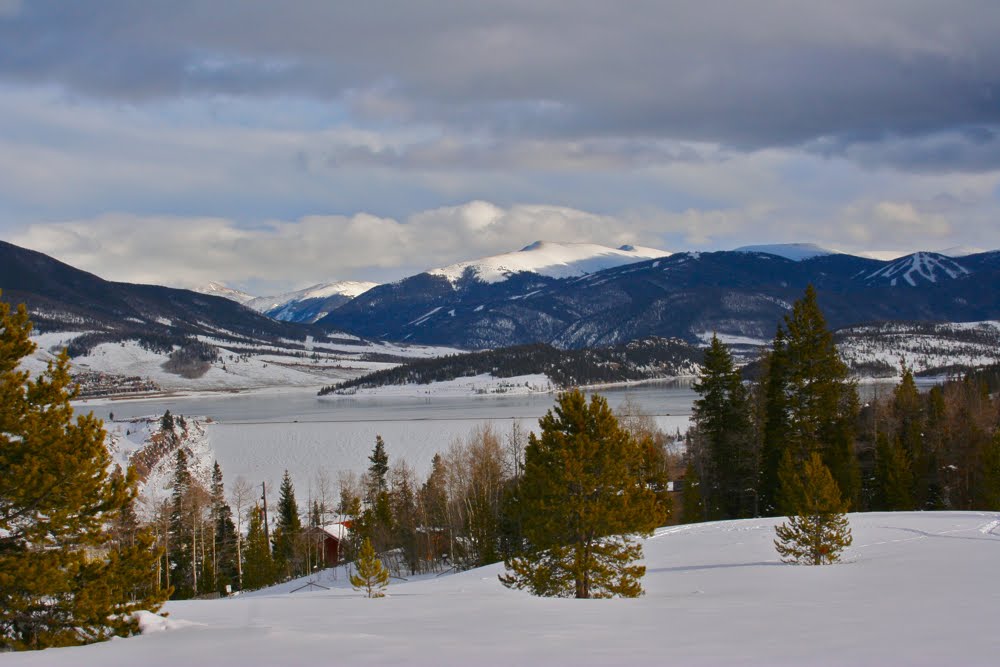
Sun glints through the high clouds in the clear area between Ryan Gulch Road and I-70.

On the slopes of Buffalo mountain between Ryan Gulch Road and I-70 is a swath of Forest Service land filled with social trails that interconnect in a million different ways. Since I frequent the area, this zone has become my place for after work or mid-day doggie outings.

Standing in the meadow near the trailhead and looking south towards I-70 and the Eisenhower tunnel

Mt. Guyot (13,370 ft) is usually visible from the meadow.

This post covers one route through this maze. It it not meant to be a guide to a particular trail but a taste of the area, particularly since there is no parking any where near our starting point.

Crossing the second meadow with Peak 1 in the distance

The right turn to cross the creek and stay on the Placer Trail

My route started at the trailhead due south of the Silver Queen West Condominiums and headed straight across a large "meadow" that is really a clear cut area. At the far end of the meadow, the trail splits. I took the left fork and headed down the hillside to another junction in a large meadow. The junction is marked by a large wooden sign that says Placer to the right and Columbine to the left. I took the right fork.

The flat zone of the Placer Trail

Looking down on I-70

The Placer Trail at this point heads down to the creek and around a bend. In the summer, I cross here and head north towards the Salt Lick Trail. In winter, the trail forks again with one route heading due east and the other crossing the creek at small pumping station. Both routes were well tracked. I crossed the creek.

Heading east again after descending from I-70

From this point, the route stays in the trees and follows a level path that might be an old flume or a irrigation ditch. It heads steadily towards I-70 and eventually comes out right below it. I took a quick jaunt up the hill to look 0ut on the zooming traffic. Directly across from this ascent the trails heads back down hill to small valley and then heads west.

The trail eventually heads north again across a small valley. The Salt Lick Trail is ahead in the trees.

Before long, the trail veered north across another valley and crosses the Salt Lick Trail. The Salt Lick is the one official trail in the area. The trail head is located at the first switchback of Wildernest Hill and the trail goes straight up the valley until it intersects the trail to Lilly Pad Lake.

Coming out at the Salt Lick Condominiums

Heading straight north up the center of the clear cut area towards Buffalo Mountain

After crossing the Salt Lick, my route headed uphill through a small gully filled with interesting rock formations and came out right at the Salt Lick Condominiums. From here the trail forked in many directions, but it was obvious which trail headed west towards Buffalo Mountain and our starting point. I followed this trail as it veered southwest and eventually ended up at the Columbine/Placer sign. From there I turned north again and retraced my steps across the clear cut area to the trailhead.

The sun begins to set

If you live in or visit Wildernest, these trails are a treat any time of year. There are golden Aspens in the fall, fields of Fireweed in the summer, and fluffy snow in winter. I have taken great great sunrise photos from this area and hope one day to capture one of the resident Moose. Don't be afraid to enter the maze. With views of Buffelo Mountain, Peak 1, and I-70 it is difficult to get lost.

Mt. Guyot (13,370 ft) and Bald Mountain (13,684 ft) through the clouds

North Rock Creek Snowshoe

Distance: 4 miles round trip Elevation: 9,180 ft to 9,780 ft Elevation Gain: 600 ft Dogs: Off leash until the wilderness boundary North...