Saturday, January 1, 2011

Bemrose Ski Circus Snowshoe

Distance: 3.6 miles round trip
Elevation: 11, 541 ft - 11,989 ft (highest)
Elevation Gain: 1,173 ft (cumulative)
Dogs: Off Leash (National Forest)

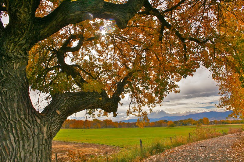
The views looking west from the Bemrose Ski Circus can't be beat

The Bemrose Ski Circus is a series of winter trails on the west side of Hoosier Pass near the Breckenridge ski resort. For the most part, the trails are unmarked and the skier or snowshoer can go where they will. We were in the Ski Circus to try out the Flume Trail, a flat trail that bisects the area. Our plans changed dramatically upon arrival, a fortunate event because the best views in the area are up high and NOT on the Flume Trail.

Trailhead sign

Map of the area courtesy of the US Forest Service

Both guide books we were using indicated that the Flume Trail was the only marked trail in the area and was marked with blue diamonds. Additionally, the National Geo and Forest Service Maps both showed the Flume Trail splitting off from the right border trail a couple of hundred yards from the trailhead.

Starting out directly behind the trailhead sign. Blue diamonds could be seen in the trees.

The reality is the Flume Trail starts right at the trailhead with an immediate left. The right border trail, in contrast, starts directly behind the sign and is marked with blue diamonds. Of course we did not know this until much later.

There were lots of interesting views to the south from the trail

We followed the blue diamonds as anticipated, continually looking for when they might split off to the left and start the Flume. We never saw this and kept climbing higher along the right border of the area. One other party had broken trail for us, so it was not terribly difficult to keep climbing. We knew we were not where we were supposed to be but the views of Mt. Lincoln, North Star Mountain, and Quandary Peak that were filling the sky line behind us, which drove us higher.

Out of the trees now and heading upwards. We knew we had missed our turn off by this point but the route look too interesting to back track.

The tracks we were following cut north near 12K feet and headed for the top of a small rise. Below was a Sprint cell phone repeater. The rise was covered in willows that made for rough going as the snow collapsed around them. The tracks headed back down the mountain via the antennas but we decided to turn back around and retrace our steps to see if we could find the Flume Trail.

Higher up both North Star Mountain and Quandary Peak form a winter tableau.

Once back down we kept looking for any blue diamond that might lead off to the right. Finally, we saw one on a telephone pole out in the middle of a meadow. We could see no others but dove into the knee deep snow to see.

Our tracks coming down the unmarked but highly inviting hillside that finally dumped us on the the Flume Trail

Standing beneath the pole the meadow dipped down sharply in two directions. One followed the transmission right of way and the other headed down into some trees. Deciding to just play, we headed down the slope, sliding, laughing, and enjoying the fresh powder. After a bit we could see a well trod trail heading north. We figured this had to be the Flume. Blue diamonds were quite plentiful for 50 yards or so.

The recessed Flume Trail. The ditch reminded me of a Civil War era sunken road.

After a quick lunch we headed up this trail that immediately dove deep into the trees in a sunken ditch that is the flume. 5 minutes of this monotonous scenery, and we were ready to turn around and go up again. Fortunately, the Flume Trail crossed a drainage and we immediately turned up it, breaking trail as we went.

Our second journey upwards

We kept going right up the gut until we crested a small rise where we could look down onto the Bemrose Creek Drainage. To our right was a ridgeline that looked easily scalable. Our GPS told us we were farther east than our turn around point on the other side. Had we the time we might have gone over the ridge to make a loop. We'll save that for another day.

The open meadow through which we climbed was bordered by a ridge to the south and trees.

Back down to the Flume Trail, we retraced our steps and at the junction where we came into it, we took the obvious turn to the right and followed this out to the trailhead. We did not see any Blue diamonds in this section, so who knows what the real route is supposed to be.

Our final turn around point. A small pass with Mt. Lincoln (14,286 ft) and North Star Mountain (13,614 ft) in the background.

The Belmose Ski Circus turned out to be a nice surprise. The view above the trees is stunning. The routes one can create are varied in both views and difficulty. Unless you are a total novice, do include a route that goes up the hillside, you won't regret what you see.

Our GPS track. We started on the lower part of the map then did the upper.
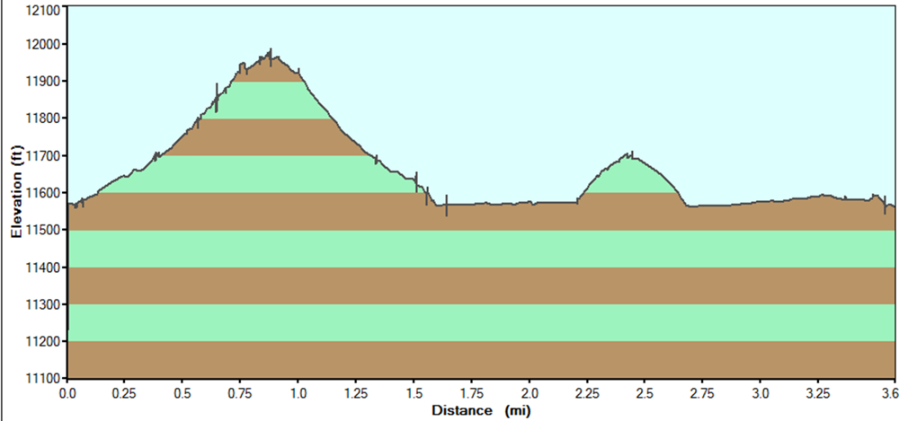
Altitude Profile

Saturday, December 25, 2010

Rainbow Lake Snowshoe

Distance: 3.3 miles round trip
Elevation: 9, 160 ft
Elevation Gain: nominal
Dogs: On leash on the bike path, off leash thereafter

Rainbow Lake on less than stellar day

Rainbow Lake near Frisco Colorado is pleasant winter jaunt to a frozen lake. The trail starts out at the parking area for the Frisco bike path, which consists of the first part of the route.

Leaving the parking lot and heading to the bike path

Walking along the snow-filled bike path

One house had filled its back yard with interesting cairns

Along the bike path you pass nice homes, some with unique decorations. At 0.41 miles is the trailhead for Mt. Royal and Masontown. At 0.75 miles is a large parking area with a sign for Zach's Stop. Turn in here and look for the brown Rainbow Lakes trail sign.

Standing in the Zach's Stop parking area. Note the brown trail sign.

A typical trail segment in the Aspens

Coming into Rainbow Lake

From this point, the trail wanders through willows and Aspens until it reaches the lake after a short rise.

Twisted roots in the snow

Heading back out

Passing a small stream with ice

On this trip, the weather was brutal with high winds, blowing snow, and overcast skies. Our motivation was to get the dogs out and anything above treeline on such a day would have been most unpleasant. I need to return and try this trail again on a nicer day.

Heading back through the willows

Sunday, December 19, 2010

Castlewood Canyon Hike

Distance: 6.4 mile loop
Elevation: 6,631 ft
Elevation Gain: 1,191 ft (cumulative)
Dogs: On leash only (State Park)
Critters: Rattlesnakes (warm weather obviously)
Date Hiked: 13 November 2010
Bathroom at Trailhead: Yes

Standing on the east rim of Castlewood Canyon. Which monolith will fall next?

Many locals never realize that eastern Colorado is filled with mysterious canyons cut into the soft rock by long forgotten rivers. Filled with interesting rock formations, petroglyphs, or dinosaur tracks, these canyons make for interesting hiking, particularly in the shoulder seasons. Castlewood Canyon State Park, southeast of Denver, is one such canyon that is relatively close to the metro area.

Thanks to my friend and hike leader Andy who gave me this image of route that he captured on his Garmin GPS. I need to learn to do this!
Starting out on the Lake Gulch Trail
The particular features of Castlewood Canyon include cool rock formations, remnants from a devastating 1933 flood that flooded downtown Denver, and several distinct ecosystems.

Looking down into the valley that was once Lake Louise. Note the Cottonwoods below. They signify the presence of water.
There are really two canyons in the park that form a slightly stretched bow tie. On this trip we walked a little over 6 miles in a figure eight around the bow tie. The route also went up and down with half our trip being on the rim and half along the creek.

Crossing Cherry Creek on some boulders. There is a bridge farther up for the feint of heart.

Looking back across the creek for a more natural view.

Our route began on the Lake Gulch trail just past the Canyon Point Parking Area. We walked along the top of the rim to a view of the valley that was once Lake Louise. Ranch land today, the valley looked lovely with a light dusting of snow glistening in the sun.

Standing on the eastern side of the dam ruins. You can see the Creek Bottom (G) Trail far below.

The route descended to the valley floor and then crossed Cherry Creek on a series of boulders. Now on the Rimrock trail, we passed the remains (at 1.18 miles) of the dam built in 1890. The dam broke in 1930 and flooded downtown Denver. The destruction of the water made as it gouged it way forward is still visible today.

The only steep section of the route was heading up the Rimrock trail to the eastern rim.

Just past the ruins, the Rimrock Trail quickly ascends (at 1.35 miles) to the top of canyon. This area is a flat plateau filled with smooth rocks and coniferous trees. There are several places where the hiker can get a glimpse of the rocks as they are splitting away from the canyon sides. In the summer, this area bakes in the sun and Rattlesnakes rule.

Looking west just after reaching the top of the rim

Our decent near the end of the canyon (at 2.72 miles) was precipitous because ice from the recent snowfall had melted into the nooks and carnies, making the entire route slippery. From this point we traveled across a bridge (at 3.23 miles) and along the Creek Bottom (G) Trail to a small waterfall (at 4.26 miles) and then back to the dam (at 5.11 miles).

A typical section of the eastern rim. Ponderosa Pines and Junipers dominate. Can't you just picture a rattlesnake curled up on the round rock?
Looking northwest towards the city of Parker
We stayed low as we switched to the other side of the bow tie and the Inner Canyon (K) Trail. This route followed the sunny side of canyon, which is filled with sun-loving Gambel Oaks (Quercus gambelii). The Gambel Oak loves thin, rocky, and alkaline soils. You find them all over Mesa Verde National Park and the four corners region of Colorado.

A nice view showing a hillside of tumbled rocks. Geology is not stagnant. We will be walking along the creek below on the return route.

In stark ecological contrast, the other side of the Inner Canyon was covered in shade and moisture-loving Douglas Firs (Pseudotsuga menziesii) and snow, snow, snow. While we basked in the "heat", we marveled at winter on the other side

The waterfall part way up the Creek Bottom Trail is packed with bathers in the summer. The landscape, including the sandstone bluffs on the left was carved by flood of '33.

Near the end of the Inner Canyon is a bridge where we finally crossed over to the snowy side. We crossed a bridge and stepped through the looking glass into a different world. Was this Narnia or Never Never Land? Every branch was coated with huge clumps of snow that looked more like a movie set than reality. From the bridge, it is a quick jaunt up the side of the canyon to our starting point (at 6.4 miles).

Looking back down the Inner Canyon at all the rocks.

Castlwood Canyon State Park is a local gem that you need to try. It can be dry and stark in the winter, brutally hot in the summer, and stunning in the spring and fall. On this trip, Denver had received it first light snowfall, and the contrasts made the area very appealing.

Crossing into winter. The leafless Gamble Oaks and rock cliffs are stark but dry. The northern side of the canyon is covered in snow.

If you liked this trail check out Spruce Mountain near Castle Rock.

Sunday, December 12, 2010

Pella Crossing

Distance: 1.5 mile loop around Sunset Pond and Heron Lake
Elevation: 5,095 ft
Elevation Gain: None
Critters: Water fowl
Dogs: On leash (this is a Boulder County Open Space Park)

Looking west from the far end of Heron Lake in the Pella Crossing Open Space Park

Pella Crossing is a lovely open space park near Hygiene that is popular with runners, birders, and fishermen. In October, I took my parents there on an afternoon stroll. I took a picture every few feet and every one was a keeper.

Map of the Open Space Park. We took the route counter-clockwise. The inset in the upper right of the maps shows the lakes on the other side of N 75th St.

Faded Yellow Rabbitbrush (Chrysothamnus viscidiflorus) clings to the side of Sunset Pond

A panoramic view. I don't know what this area is like in the spring, but in the fall, it is sublime.

The entire route is as wide, flat, and appealing as this shot.

The area consists of several adjacent lakes with a well-groomed, handicapped-accessible trail that winds around them. Open fields and Cottonwood trees line the route and skydivers were seen jumping from a plane overhead to land in a nearby airport.

Sun glints through a very large Narrowleaf Cottonwood (Populus angustifolia )

A seed pod from the Common Milkweed (Asclepias syriaca) cracks open in the warmth of the Indian Summer sun.

The fibers of the Milkweed plant were used in WWII to stuff life preservers and are now used in many other products since it is better than down in insulating properties.

Fishing for Large Mouth Bass is encouraged and belly boats are common. There are actually 5 lakes, 3 on the east side of N. 75th Street and 2 on the west side. We only walked around the lakes on the east side (Sunset Pond and Heron Lake), but a longer route is possible by crossing over and walking the other side.

The back side of Sunset Pond

Long's Peak (14,259 ft) is barely visible through the clouds that hang over the mountains.

Fisherman in a belly boat drifts serenely on the west end of Sunset Pond. The lazy movement of his fins did not disturb the glass-like surface of the water.

Monday, December 6, 2010

Alluvial Fan Nature Hike

Distance: 0.5 miles
Elevation: 8,557 ft - 8,640 ft
Elevation Gain: 83 ft

In the center of the Alluvial Fan

The Alluvial Fan is a short but scenic trail in Rocky Mountain National Park suitable for elders and children. The trail crosses an area of waterfalls, boulders, and Aspens that formed when the Lawn Lake Dam broke upstream on July 15, 1982. Shortly after 5:30 AM, water and debris tumbled down the Roaring River Valley. People camping along the river reported that the water rose 22-30 ft. One camper in this area was killed.

Fall color amongst the rocks

As the water exited the narrow river valley and spread out into Horseshoe Park, it overran a campground and killed a few more people. Logs, house-sized boulders, and sand was dumped into a large pile.

Looking at the debris from the west side

The water then traveled toward the town of Estes Park, the gateway community to Rocky Mountain National Park. It took out a small hydroelectric power plant and fish hatchery before sending a river of mud through the downtown area. Finally, the water flowed into the Big Thompson River and dumped into Lake Estes. Total cost of the accident was $31M.

The river is much calmer now

Today, a walk across this debris field is both scenic and sobering. Tourists gather amongst the rocks, water either roars or trickles through the area depending upon the season, and trees have grown up along the edges. The route has minimal elevation gain and winds through the debris. It is 0.5 miles between the east and west Alluvial Fan parking lots and roughly 0.25 miles from either lot to the center of the fan. From the top of the mound there are also great views of the Endovalley/Horseshore Park area.

North Rock Creek Snowshoe

Distance: 4 miles round trip Elevation: 9,180 ft to 9,780 ft Elevation Gain: 600 ft Dogs: Off leash until the wilderness boundary North...