Friday, October 29, 2010

Skinny Fish Lake Hike

Distance: 5 miles round trip
Elevation: 9,269 ft - 10,269 ft
Elevation Gain: 1,000 ft (net), 1,432 ft (cumulative)
Dogs: Voice and Sight Control (Flat Tops Wilderness)

The right-hand side of Skinny Fish Lake. There was one tent on the far end but not another soul around.

Skinny Fish Lake is a short (but not nearly as short as the Forest Service advertises) trip to a scenic lake surrounded by the infamous Chinese Wall, a unique geologic formation in the Flat Tops Wilderness. We chose this trail because we thought it was really short (advertised distance is 3 miles round trip) and we just wanted to stretch our legs after driving the Flat Tops Scenic Byway.

Looking south from the parking area

Looking up the drainage from the parking area

The trailhead for this hike is located on Trappers Lake Road in the Flat Tops Wilderness. It is clearly marked on the map and the parking area is quite obvious.

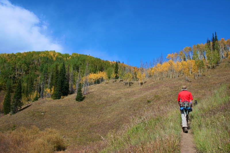
The initial pitch. The sky is still blue, but storm clouds are brewing to our left.

The lower portion of the trail winds through Aspens. The forest was damp and earthy, just what I want in the fall.

The trail begins by heading up a steep hill filled with Aspens. On this rainy fall day, they were in full color. At 0.9 miles is the junction with the Lost Lake Trail. Lost Lake is on the other side of the wall and this trail goes around it reach the lake. After crossing a small stream (nice bridge), the trail enters a broad, grassy meadow. Here the eastern portion of the wall comes quickly into view. Its stair-stepped features are both interesting and intimidating. This is one large hunk of rock. At 2.11 miles is the intersection between the Skinny Fish and McGinnis Lakes.

Even the undergrowth was putting on a show

Looking back down the drainage. The sky is getting more threatening

Since our time was short, we chose to head towards Skinny Fish Lake since we guessed that it would not be totally in the trees. This turned out to be a good choice. The lake is surrounded on 2 sides by the Chinese Wall. It is broad and welcoming. I can not report what McGinnis Lake looks like, but if you go all the way to Skinny Fish, you might as well pop over to McGinnis.

Our first glimpse of the effects of the Big Fish Fire

A scenic creek. It is raining by now.

A good portion of the trail traverses the 2002 Big Fish Fire area. This lighting sparked fire burned over 17K acres of prime wilderness. The skeletal remains of Aspen and Lodgepole stand as a stark reminder to the transience of Nature. Nothing is permanent.

Fall willows and dead trees make a startling contrast

The Chinese Wall comes into view. This picture does nothing to capture the scale. The wall dominates the valley and seems to loom over everything.

This trail held another surprise for me. In the Flat Tops Wilderness, dogs do not have to be on leash if they are under voice control. I guess it is only the crowded Front Range Wilderness Areas where the leash law is mandatory.

Looking back towards the trailhead from the middle of the meadow.

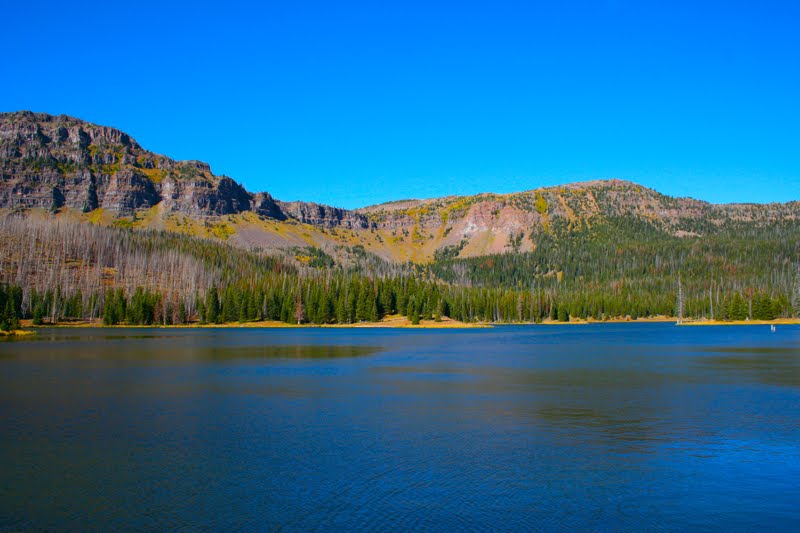
Looking straight across Skinny Fish Lake to the Chinese Wall beyond. Blue skies return. Such is Colorado and why we always carry rain gear.

On this trip, this was the only hike we did in the Trappers Lake area. There may be others that are more scenic, but for us, this trail hit the spot. It got our legs moving and we got close to the Chinese Wall, which was another objective. Little did we know that the following day we would climb to the top of the wall on our harrowing trip to the Devil's Causeway.

Monday, October 25, 2010

Scenic Drive: Flat Tops Scenic Byway to Trappers Lake

Hikes in the area: Skinny Fish Lakes, Trapper's Lake, Devil's Causeway


A zoomed view from Dunckley Pass looking deep into the valley
The Flat Tops Scenic Byway will make you GASP in the fall. It is by far the most scenic drive in Colorado I have driven thus far. While other roads let you glimpse Aspens, this road lets you wallow up to your neck in Aspens. After a couple of hours driving, you will run out of explicatives and just start grunting, moaning, and hyperventilating. And that is just the start. This was an all day drive. My destination was Trappers Lake. I had so many photos it was hard to decide on which ones to post. Unfortunately, I was shooting with the sun high in the sky, which is not the best.

This is the route I took...
  • From Yampa go north on County Road 17, which becomes County Road 19.
  • Turn left onto County Road/State Highway 132, which becomes County Road 8
  • From County Road 8 turn south onto County Road 8a/Trappers Lake Road/Colorado Hwy 155
All of these roads are clearly marked on the Colorado Gazetteer but may not be listed on a typical AAA map.

A broader view of Dunckley Pass showing the peaks in the distance

Ho hum, more pretty Aspens

The day started out cloudy and stormy
We are not even to the pass yet and the color is everywhere


I liked hillsides where you can see the white trunks of the trees

Looking west from a vista point. This road leads to Meeker. I would cross it going towards Trappers Lake
At twilight we came across this herd of Sheep being watched over by several sheep dogs. The Meeker area is a large Sheep raising area.

Thursday, October 21, 2010

Scenic Drive: County Road 18 to Pleasant Valley

The Yampa river winds through Pleasant Valley in the fall.

Pleasant Valley is a local name for a small meadow where the Yampa River and Sarvis Creek intersect. John Fielder photographed the area, which is why we took the detour to the spot on our way to the Flat Tops Wilderness.

Note the post piles of Blacktail Mountain. Hexagonal post piles are rare because lava must cool evenly for them to form.

To get to Pleasant Valley, drive around Stagecoach Reservoir on County Rd 14. On the north side, County Rd 18 splits off to the right. Don't go into the park, but stay to the left as the road winds further around the lake.

At the bottom of the road is Pleasant Valley

The road will come to a steep hill near Blacktail Mountain, a volcanic remnant, and then head steeply down through willows. Near the bottom of the road you can pull over and admire the view. At the bottom of the valley is the trailhead for Sarvis Creek.

The back side of Blacktail Mountain

Sunday, October 17, 2010

Scenic Drive: Highway 134

Distance: 27 Miles
Highest Point: Gore Pass at 9,527 ft

Rolling hills and Aspen stands dominate Highway 134

Highway 134 is a short, paved, 27-mile, east-west route that starts 6 miles north of Kremmling. Its western terminus is near Topanas on highway 131. On this trip, I did not drive all the way to Topanas, however but turned north onto County Rd 16 going towards Stagecoach Reservoir. I also took a side trip onto CO Hwy 117 because it was filled with Aspens. Hwy 117, a dirt road, dips down into ranching country, becomes County Rd 16, and then regains Hwy 134. Note, this side trip crosses a large stream. Low clearance vehicles are not advised.

Looking down into Forest Service Blacktail Creek Campground. The camp sites are nestled in juvenile Aspens

Another stand of Aspens


My destination...The Flat Tops Wilderness... seen through a stand of Aspens

The highest point on Highway 134 is Gore Pass at 9,527 ft. Much of the topography is Sagebrush shrub lands mixed with Aspens on the hillsides.

CO Hwy 117 detour

This stand of Aspens was visible from Hwy 134. I could not help but drive up to it and walk along the dirt road for a while. The air was a balmy 70°. Fall had come to the Rockies.


Past the Aspen grove, Hwy 117 dips down into a valley. This ranch came into view. We passed the rancher, a hardy woman, fixing her barb wire fence.

Past the ranch house was this old cabin. You can see the Sagebrush covering the empty hillsides.

A close up of the Sagebrush with an Aspen-covered hillside in the distance.

Wednesday, October 13, 2010

Masontown

Distance: 2 miles round trip
Elevation: 9,133 ft - 9,590 ft
Elevation Gain: 457 ft
Dogs: On leash for the first half

The uninspiring remains of Masontown

There is not much left of the ghost town of Masontown on the slopes of Peak 1 near Frisco to make it a worthy destination. Most people in fact, pass it on the way to Mt. Royal, a precipitous overlook higher up the mountain. Masontown was destroyed in an avalanche in 1926. After seeing some of the avalanche chutes around here, I can understand why there is not much left.

It is 200ft from the parking lot to the bike path.

Take a left here. Don't worry you won't be walking all the way to Breckenridge.

The bike path

Still, if you want a short hike that will get your heart pumping this is it. While the first 0.42 miles are flat, the last 0.54 miles gains 457 ft. Sprint this short stretch a few times and you'll be ready bigger and better things.

The trailhead. The sign says Mt. Royal. There is a small interpretive sign talking about Masontown.

Between the town of Frisco and Peak 1, there is a huge pile of boulders that have tumbled down from the mountain. This trail looks down upon these rocks.

An early trail segment

Frisco and Lake Dillon in the distance

I did this trail on a lazy Sunday in September and it was pleasant indeed. The undergrowth was turning scarlet and yellow and berries of various varieties were glistening "on the vine".

A rare, level trail segment

Mountain Juniper

This is one of the social trails that head off to the left.

Fall comes to the undergrowth

We have been having unseasonable warmth this year, so the air was not exactly crisp, but the shaded trail provided a little coolness that hinted at the coming chill.

Another trail segment

The only really obvious sign of Masontown is a small pile of rusted metal just as you enter the area.

To the left as you arrive are two trails. The lower trail heads down the slope and eventually peters out. The upper trail continues to Mt. Royal. There are no signs indicating this.

More evidence of the town. This piece if metal was down the lower trail.

Tenderfoot is a much better doggie outing than this route. On the first half (the bike path) dogs must be leashed. I am not sure I could survive a half mile with my dog on a leash.

The ghosts of the miners wiped out in the avalanche still linger....

Berries on the trail

Another hint of fall

North Rock Creek Snowshoe

Distance: 4 miles round trip Elevation: 9,180 ft to 9,780 ft Elevation Gain: 600 ft Dogs: Off leash until the wilderness boundary North...