Friday, June 18, 2010

Lion Gulch

Distance: 6.67 miles round trip to to the Homestead Act sign, 6.88 miles roundtrip to the first homestead sign, 7.12 miles roundtrip to the Walker Homestead, 8 miles round trip to the Griffith homestead
Elevation: 7,370 ft - 8,447 ft
Elevation Gain: 1,077 ft (net), 1,387 ft (cumulative)
Dogs: Off Leash (this is Forest Service land)

The Griffith Homestead (2003)

The Lion Gulch Trail (off of Hwy 36 going to Estes Park) is one of the few Forest Service trails within easy driving distance of Boulder. It is not my favorite trail because the views are few and the water crossings many but on the right day it can be serene and welcoming.

The trailhead


One of the nicer trail segments

This trip, was not the right day! Due to recent snowfall, the Little Thompson River was overflowing its banks and we had to navigate around 6 tricky water crossings. Two of those were across dead fall that previous hikers had lain in a pile in the torrent. That sort of crossing fills me with anxiety. I have no desire to get my camera wet or twist and ankle and be out for the season. We managed to get across though with the help of another large branch that we used like a giant's walking stick.

The creek in a kinder, gentler time of year

Much of Lion Gulch is in the trees

We ended up on this trail because it was lower in elevation than others and our recent May snow storm had left a pile of the white stuff in all the places we wished to go. Alas, one mile into the journey we ran into snow and it stayed with us the whole way. I would have really thought that the snow in the wide-open expanses of Homestead Meadows would have melted in the direct sun, but it had not. It felt like January, not May. Not the best time to visit Lion Gulch. At least we got some exercise.
The entrance to the meadow (2003)

Looking to the side of the trail (2003)

This trail can be quite appealing in the summer, however, when the grasses are green and the sky is blue. Since this trip was rather dreary, I have decided to use photos from an earlier trip done in the summer of 2003 (my last trip to the area) to illustrate the route and so hopefully not turn you off with all my negative comments.

The first homestead is at the top of the rise (2003). In 2010 the trail was filled with flowing run off.

The first homestead is in the trees to the right and the Griffen Homestead is through the trees at the back of the photo (2003).

The trail itself leads to Homestead Meadows, a wide open area filled with old cabins from the 1930s. My favorite cabin, the Griffen Cabin, has fallen down in the 5 years since I have hiked this trail. That was sad to see indeed. It was quite picturesque sitting next to a large Ponderosa Pine.

Getting closer to the Griffen Homestead (2003)

The remains of the first homestead

The other things to note about this trail are:
  • There is a very large parking lot and bathroom at the trailhead.
  • The trail descends sharply down to the river and then winds back upwards until it rises above the road.
  • There are quite a few water crossings.
  • The trail is rocky in places and there is one very steep and rocky ascent.
  • The mileage listed in most trail guides is just to the entrance of the meadow. Visiting the homesteads is an additional distance.
If you like hiking in the trees along a vocal river, then Lion Gulch may just be the trail for you. Homestead meadows is a pleasant area and I can see why the homesteaders themselves chose to live there despite the hardships.

The backside of the Griffen cabin (see the teaser photo for the front) in 2010. Most of it has collapsed.


May 2010 was not the best time to visit Lion Gulch


Once you get into the meadow, you can hike for miles if you like. I recently had two friends do this. They promptly got lost and wandered around for 9 hours. There is a lesson for you, always carry a map!

Sunday, June 6, 2010

Goose Creek

Distance: 11 miles round trip
Elevation: 8,247 ft - 8,708 ft
Elevation Gain: 500 ft net (1,876 ft cumulative)
Date Hike: 5 June, 2010
Dogs:  Leash only, wilderness area

Looking north into the Lost Creek Wilderness from our turn around point

Goose Creek Trail in the Lost Creek Wilderness is a journey into an alternate universe of pink, taffy-twisted granite formed into giant domes or pinnacles of inhumanly large Legos. A few miles up the trail and you will wonder where you are. Had the rock been gray instead of pink, I would have thought I was in the Sierra Nevada Mountains. I am so used to Colorado's jagged peaks that I forget just how geologically diverse Colorado really is. I have to remind myself that the eastern plains contain sandstone towers like the Pawnee Buttes as well as deep canyons like Vogel Canyon. The broad area near Lost Creek is another such geological wonder. The rock is called pink Pikes Peak Granite and the principal process carving the rocks is weathering and erosion.

The start of the trail. You can see the burnt trees
Crossing Goose Creek
A typical trail segment
The route to the trailhead is long and arduous if coming from the Denver area. It is complex enough that I have included detailed instructions at the end of this post. Much of the drive is through the Hayman burn area which is both fascinating and tragic at the same time. Like the scenery on the nearby Gashouse Gulch Trail and the Pine Valley Loop, the skeletons of burnt trees stand as foreboding sentinels to man's seemingly inability to preserve the natural world.

Rock formations viewed from the trail

Goose Creek is a haven for backpackers of which we saw plenty. In fact, there were so many cars in the parking lot that we had to park on the road. Since we only ran into 2 other day hiking groups, the rest must have belonged to backpackers who had mostly likely slunk in Friday night and absconded with all the parking.

The trail itself is mostly a wide dirt path filled with gravel. It weaves up and down in a continuous wave, which became really fatiguing on the return trip. I measured the cumulative elevation gain on my GPS and came up with 1,876 ft roundtrip. Some other estimates online were very similar. By the time I returned to the car, I could believe it.

At times the trail meanders through a Ponderosa Pine and Douglas Fir Forest and at other times is perched on a hillside with stunning views of the various rock formations. It can be snowy in the winter and very hot in the summer. We had originally planned on doing this hike 3 weeks ago, but had to cancel due to our May snow dumper. It was around 80° on this trip and the granite rock reflected the sunlight back and forth across the canyon. After our prolonged winter, the heat was most welcome.

Our first overlook at 2.8 miles. Taken from atop a large dome. There is a tree and some branches that make getting up the dome easy.
Kate and Michael at our lunch spot looking south down the valley. To the right out of from are huge gum-ball boulders with shade.

Here are some mileage milestones of our journey: 2.84 miles turn off to a large rock (easy scramble) for incredible views of the Harmonic Arch Area, 4.33 miles turn off to the Shaft House and some historical buildings, 4.71 miles continue from the building towards Shaft House to a super-sized promontory where we ate lunch, 5.36 miles to the Shaft House, and 5.66 miles to a large pile of rocks (here that is like saying "to a tree" in a forest of trees) where we scrambled to our final view of the area.

One of the old cabins that housed the workmen trying to dam Lost Creek
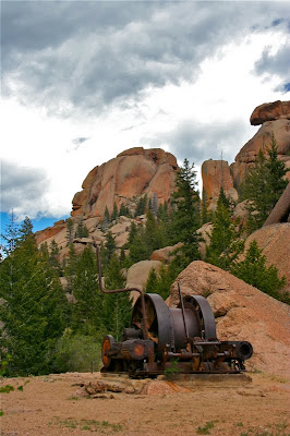
The Shaft House is the remains of a large engineering project that tried to dam Lost Creek. Fortunately for us, this effort failed or this unique and irreplaceable geological and biological area would have been under water.

An unusual formation on the way to the Shaft House

Just beyond the Shaft House is a large barrier of rock. You can actually scramble up these rocks, scurry down a tunnel and wiggle through a narrow shaft to a huge granite shelf overlooking the upper basin. This was by far the most scenic view on the trip. The rocks here were particularly close. You can actually see how the molten rock was twisted into unique shapes and then left to cool. The faces of two long lost hikers loom over the area, protecting the Lost Creek Wilderness from further attempts at exploitation and degradation. May it always be so.

The Shaft House. The structure is gone, but the 1930's machinery remains

The narrow cleft we squeezed through on our view to our final view.

Directions:

Take 285 south for 21 miles to Pine Junction. Turn left onto county road 126 towards Pine and drive an additional 22 miles to a Forest Service road just past the Cheesman Canyon trailhead. This road is dirt, washboardy, and slow. Plan on 45 minutes from this point to the trailhead. Two mile up this road turn right at the "Lost Valley" sign. Drive 1.1 miles to a junction with several large brown signs. Stay to the left on Forest Service Road #211, which is indicated by one of those flexible Forest Service road signs. After another 5.2 miles there is another intersection marked by a "JVL Lost Valley Ranch" sign. Turn right and drive 4.7 miles. You'll pass the Goose Creek campground about half-way and eventually come to another intersection with a sign pointing to the trailhead. Turn right here and park 1.3 miles up. From Denver the trip is around 150 miles and takes almost 2 hours.

A giant rock pile at our final view

A close up of the top of the above rock pile. Note the two faces on either side

Thursday, May 27, 2010

Oregon: Columbia River Gorge

View of the Columbia River Gorge from the Portland Woman's Forum Scenic Viewpoint. Vista house is on the cliff to the right.

The Columbia River Gorge is a pastoral beauty that changes gradually with the seasons. It has sweeping vistas, a plethora of waterfalls, and giant slugs. What is not to like? While I-80 now zips through the gorge, to really see it, you need to take the history highway that starts in Troutdale and which winds lazily through the countryside. This was a great route to take my parents on. Most of the sites are easily accessible a short walk from the car. Below are a series of pictures from the trip.

Looking towards Portland from the Vista House

Looking down the gorge from the Vista House

A close up of the vista house and the mountains beyond

Could this be a brown specimen of the nefarious Banana Slug?


Latourell Falls


Common Camas (Camassia quamash)


Wahkeena Falls


Multnomah Falls


Bonneville Dam and Hydroelectric Power Plant. The roar was something to behold

This Eastern Gray Squirrel (Sciurus carolinensis) was unafraid of our car and my camera.

Monday, May 10, 2010

Oregon: Silver Falls State Park

South Falls

Silver Falls State Park is a phenomenal destination only an hour northeast of Salem on highway 214. It is located in a temperate rain forest in the foothills of the Cascade Mountains. 100-year old moss, ferns, and raging waterfalls are just some of the sites one can expect in the park.

South Falls Close Ups


I was traveling with my parents so we visited the falls that could be seen from the road or on short walks an level terrain.

Winter Falls


North Falls

Taken with a telephoto lens from the North Falls view point on Hwy 214 going towards Silverton

On this trip I was continuously amazed with Oregon weather. In the several hours we were at the park, we were hailed on twice and between each deluge, we had warm sunny skies!

The rain forest

The trail heading down to the bottom of South Falls. Every inch is covered with something growing!


Flowers


Mosses


North Rock Creek Snowshoe

Distance: 4 miles round trip Elevation: 9,180 ft to 9,780 ft Elevation Gain: 600 ft Dogs: Off leash until the wilderness boundary North...